Sunday, October 2, 2022: This morning we drove to St. Andrews by-the-Sea in New Brunswick, almost to the U.S. border in Maine. But before we went into the town, we drove over a sand bar at low tide to Ministers Island.
Ministers Island
The Passamaquoddy people lived on this island, Qonasqamqi Monihkuk, for thousands of years. In 1790, Samuel Andrews, an Anglican minister and Loyalist, built a home here, hence the name. Around 1890, William Van Horne, visionary builder of the Canadian Pacific Railway, established his summer estate here.
The 490-acre Ministers Island stands several hundred meters offshore in New Brunswick’s Passamaquoddy Bay, immediately northeast of St. Andrews-by-the-Sea. It is a geographical oddity in that it is accessible at low tide only by the wide gravel bar suitable for vehicular travel.
It is possible to drive, walk, or bike to the island at low tide; we drove. We were adequately warned to make sure to leave the island before the tide came in or we would be stuck for another 6 hours. The sand bar that connects Ministers Island to the mainland is under at least 14 feet of water at high tide. Tide schedules change daily so it was essential to check the tide chart posted at either end of the bar before crossing. We were warned we should NOT attempt to cross on foot or by vehicle if there were water on the bar as the tide is swift and the water frigid.
Here we are crossing the sand bar to the island.
We drove across at 10:51 a.m. and on the island side, they told us we had to leave the island by 2:00 p.m. or we’d have to wait 6 hours to leave. The overall tide change is 16 feet, covering the sand bar “road” totally.


This huge island estate, once completely self-sufficient, was the summer home of Sir William Van Horne (1843 – 1915), chairman of the Canadian Pacific Railway from 1899-1915. Today, Ministers Island is a Provincial and Federal Historic Site and is managed by the Van Horne Estate on Ministers Island, Inc. a community-based non-profit dedicated to preserving the nature and history of the island.
In 1891, construction began on the house named for Sir William Van Horne’s father, Cornelius Covenhoven Van Horne. What started as a somewhat modest summer cottage, after as many as seven modifications, became the 50-room residence of today. It was supported by numerous outbuildings, including a windmill and gardener’s cottage.
By the time of Van Horne’s death in 1915, the island had been transformed into a small idyllic utopia, revolving around the sandstone mansion known as Covenhoven. It was furnished in a lavish late Edwardian manner, with manicured grounds, scenic roads, greenhouses turning out exotic fruits and vegetables as well as a breeding farm.
First, we came upon the large chateau-style barn, designed for Van Horne in 1898; it is one of the largest in The Maritimes, and it was often regarded as the most beautiful. The barn was used for breeding of Van Horne’s prizewinning Clydesdale horses and Dutch-belted cattle, one of the only such herds in North America.
The farm was also home to pigs, geese, ducks, chickens and turkeys. The produce of the farm and gardens was shipped to Montreal by night train during the winter months, providing the family with fresh food throughout the year. The barn was surrounded by several outbuildings, including a creamery, smaller barns and living quarters for the workers. Workers in the barn wore white lab coats. The story goes that, on a visit to the barn, Van Horne saw workers staring out the window. To ensure maximum productivity, he had the windows moved up above their sight lines.
Originally 23 buildings stood on this property, many of which were part of the farm operation. Milk produced by the Dutch Belted Cattle was piped from the barn to the Creamery.


We went on a tour through parts of Covenhoven, Sir William’s 50-room summer home, which has an old windmill sitting out back.
We were told that in the dining room, leading American and Canadian businessmen, railway barons, Japanese royalty, and well-known members of international society dined at the table, which could seat up to 24. Dinner for the men was followed by port, cigars and billiards. For the ladies, it was playing cards and relaxing by a roaring fire in the living room.
Here, Van Horne pursued his diverse interests from art to zoology. A talented amateur artist and collector, Van Horne used this island estate to encourage Canadian landscape painting.
After the tour, we were left to wander through on our own. The cottage-turned-mansion was quite impressive.


In one part of the home, we learned about Van Horne’s efforts on behalf of national parks in Canada. In 1883, at Van Horne’s suggestion, the federal government began to consider the creation of national parks and in 1885 set aside land around the sulfur hot springs in Banff for public use. Legislation was passed in 1887 making it the first National Park in Canada. Today Parks Canada manages 168 national historic sites, serves as Canada’s representative at the United Nations World Heritage Committee and is responsible for the administration of 11 of Canada’s 17 World Heritage Sites.
The summer estate reflects Van Horne’s vision of the importance of tourism and agriculture in Canada’s development. The buildings are in the Shingles style, popular for resort architecture in Canada in the late-19th and early 20th centuries.


As we wandered outdoors on the grounds of the estate, we were confused by the time. Our cellphones kept picking up Maine time (the state is just across the water), which was one hour behind. The time on my phone was showing it to be one hour earlier than it was. So at 2:00, when we were supposed to leave the island, my phone could have been showing 1:00, thus giving us the mistaken impression we had an extra hour before we had to leave the island. If we had not realized what was happening, we might have been stuck on the island another 6 hours.
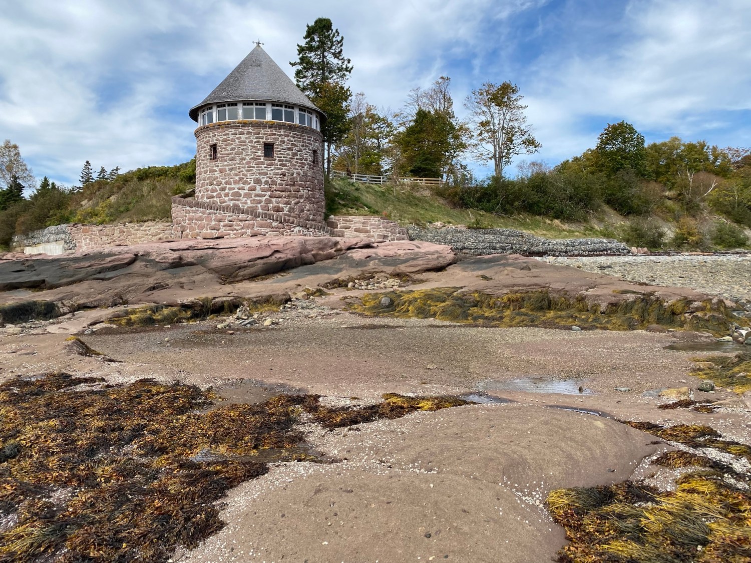
We walked to the southern tip of the island, where Van Horne had constructed a bathhouse from red sandstone blasted from the beach below; the perfectly round two-story building was completed in 1912. The upper level offered panoramic views of the bay while the lower level contained changing rooms and provided access to the beach via a circular walkway and the family’s in-ground tidal saltwater swimming pool. We walked on the rocky beach and were battered about by the icy wind.


Before leaving the island, we saw Cedar Lane, a cedar-lined foot and carriage trail to the Covenhoven estate. We left Ministers Island at 12:40, in plenty of time to avoid being trapped there for six hours, and headed to St. Andrews-by-the-Sea.


Here we are driving across the sand bar back to the mainland.
St. Andrews-by-the-Sea
We had a nice lunch at Niger Reef Tea House in St. Andrews. I enjoyed fish cakes with lemon dill aioli and Mike had Veggie burgers: mixed bean and roasted vegetables with sun-dried tomato pesto.


St. Andrews-by-the-Sea, on Passamaquoddy Bay, was designated a National Historic District in 1998. It has long been a summer retreat of the affluent, and mansions ring the town. Of the town’s 550 buildings, 280 were erected before 1880, and 14 of those have survived from the 1700s. In 1777, Loyalists from the U.S. moved north to escape the Revolutionary War and settled in what is now St. Andrews in 1783. Some Loyalists even brought their homes piece by piece across the bay from Castine, Maine.
We walked past the blockhouses built to defend the batteries that were meant to protect the harbor and river from privateering raids. Fort Tipperary, a modest fort, had been built in 1808 above the town, but citizens felt it didn’t protect the harbor sufficiently. During the American Revolution privateers attacked and robbed every port in the Maritimes except Halifax. In wartime, governments licensed private businesses and ships to seize enemy vessels and cargoes as “prizes.” This was frequent along the east coast during the War of 1812. Licensed American privateers were drawn to the ships for their valuable cargoes, or to the town to loot prosperous homes and businesses. Privateering was a common wartime practice until the mid-1800s.


We strolled the streets of St. Andrews, stopping at various shops, including McGuire Chocolate Company for hot chocolate and pumpkin spice latte. Another shop, Kilt & Kaboodle, sold woolen sweaters, scarves and hats made in Killarney, Ireland. I bought a fisherman’s hat, which Mike enjoyed poking fun at, calling me “Roscoe” and other crazy names. He said I reminded him of Susie in The Marvelous Mrs. Maisel. That hat gave us lots of laughs throughout our trip.
Mike bought a nice plaid shirt in The Leather House and I bought a cool scarf in browns and creams. I also bought some earrings at Warm & Coasty Boutique. I always enjoy our shopping time during our travels. 🙂
We walked out on the wharf and saw the low tide, the waterfront and people in life vests preparing to sail off on a cruise.


We also saw cool murals, The Kennedy Inn, and the Pendlebury Lighthouse, aka the St. Andrews North Point Lighthouse. Built in 1833 at the tip of the peninsula, it was deactivated in 1938 and has since been restored and registered as a Canadian historic place.


In 1840, the Charlotte County Court House was built and used continuously until 2016. Next to it was the Charlotte County Gaol, which operated between 1834-1979. It accommodated the jailer and 17 prisoners. The Presbyterian Greenock Church, built in 1824, was the second church built in town.


We had left Ministers Island at 12:40. While leaving St. Andrews at 4:00, we drove by again. It wasn’t yet high tide (which was at 5:30 p.m.) but at that time we could no longer see the sand bar.


Lepreau Falls
On our way to Saint John from St. Andrews, we stopped at a gas station where the young man behind the counter was quite friendly and garrulous. After complimenting my “shirt” (I had on a vest and shirt), he asked where I was from and wanted to know all about Virginia. He told me chunks of his life story, how he lived with his grandmother in Florida two months out of every year and how he had friends he wanted to visit in Virginia. He told us we should visit the nearby Lepreau Falls Provincial Park. Since it wasn’t too far out of the way, we stopped and had the waterfall to ourselves.
The name Lepreau Falls is of French origin and is a derivative of la pereau, for “little rabbit.” The contemporary spelling has prevailed since the mid-19th century.
The rapids above the main falls produce white caps and eddies which culminate with a roar over an 8-meter rocky ledge into the Bay of Fundy at its base. It is one of New Brunswick’s best “drive-by waterfalls.”
Of course Mike requested that Roscoe (the name he began calling me with my new fisherman’s hat) pose for a picture wearing the aforementioned hat.


Saint John
Back in Saint John, we went to dinner at Mashawi Zen Syrian Food. The door was locked though signs were outside on the sidewalk indicating it was open. We knocked on the door and the guy there grudgingly opened the door. He took his sweet time waiting on us and then revealed that they didn’t have any meat at all. We ordered the Aleppo Fava Beans plate, a very rich dish into which we dipped bread. Mike had a lentil soup, Mamounieh. All in all, it was very disappointing.
As we walked out, a guy walking by on the street said, “Did you like it?” We said, “They were out of everything!” Mike added, “…because it’s a Sunday.” The guy said, “Great to use ‘Sunday’ as an excuse!” He added, “It’s not my thing.”


We went to our apartment where we got cozy, watched Virgin River, and prepared to move to Alma the next day.
Steps: 12,183; Miles: 5.16. Drove 144 miles. 🙂


You must be logged in to post a comment.