On the Wednesday during our week in Cuenca, we headed west to Parque Nacional Cajas. We drove the rental car we’d picked up at the airport the evening before, a white Toyota Yaris. When we stopped to buy some extra masks at a gas station, one of us did something to set off the car alarm and we couldn’t figure out for the life of us how to turn it off. We turned on the car, we turned off the car, we closed and opened both doors. Nothing worked. Finally we started driving through town, with the car alarm blaring away. We couldn’t figure out how to stop it and we felt like damn fools driving down the road. Finally we pulled into a parking lot, people glaring at us all around. Somehow the infernal noise stopped. We had no idea how we did it, and we resolved we’d have to go back to the airport the next day to have the rental agent check it out.
Gustavo had told us to take a sharp left at a sign for Laguna Llaviucu before we reached the actual park. We headed down the very steep and rough road. We bounced along for what seemed an eternity with no end in sight. Finally we turned around because we didn’t want to risk getting a flat on our car. Back at the top, we saw on the sign that it was 2.3km to the lake, and we’d probably gone 2/3 of the way, but by this time we’d had enough; we headed straight to the National Park.


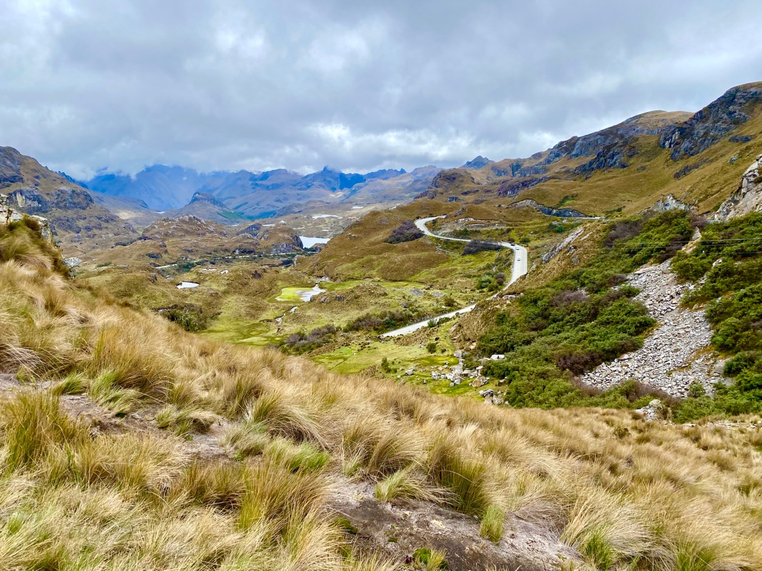
Parque Nacional Cajas lies 30km west of Cuenca and encompasses 2,854 sq. km. of golden moor-like páramo (high altitude Andean grasslands) dotted with hundreds of cold lakes set in a bleak rough countryside.
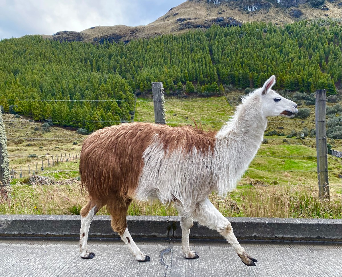
a friend we met on the road to Park Cajas
The park, a place of water, sits at altitudes over 3,100m (10,170 ft), resulting in tundra vegetation that blankets the area. A network of 786 lakes, lagoons and ponds are connected by crystal clear streams. A carpet of sponge-like plants absorb water, releasing it slowly over weeks and months. We found spongy mosses, succulents, and the amazing straw grass that is mesmerizing to behold. High altitude scenic drives reach elevations as high as 4,310m (13,550 ft).
It is doubtful that the park’s name comes from cajas (boxes) because the lakes resemble them. It’s more likely it comes from the Quichua word cassa meaning “gateway to the snowy mountains.” It could also come from caxa, the Quichua word for cold.
Cold it was. We had multiple layers on, but we weren’t quite prepared mentally for the frigid temperatures. After checking in with our passports at the park’s information center, we started our hike around Laguna Toreadora. We walked counterclockwise but in retrospect, I wished we’d gone clockwise, as most of the climbing was on the south side of the lake. Because of the elevation, I got winded every time we had to climb.


Forests of “paper trees,” also known as Polylepis trees or Quinuas, are found in sheltered hollows and natural depressions. Polylepis trees have adapted to grow at higher elevations than almost any other tree in the world.


After a good three hours of hiking, we were chilled since the weather had been cloudy, blustery and cold. We huddled over steamy hot chocolate at the café and then drove up to Mirador Tres Cruces, which marks the continental divide where the drainage basin on one side flows to the Pacific Ocean and the basin on the other side flows to the Atlantic. The road to Guayaquil goes over this pass.


We drove back to our Airbnb in Cuenca, where we rested and soaked in our hot tub. I hadn’t been feeling very good, so the nice soak felt delectable.
We were so exhausted that we barely managed to drag ourselves out to dinner at El Jardín in Hotel Victoria. The place was rather deserted and a little too formal for our taste. It overlooks the Río Tomebamba, but it was too dark to see the river by the time we arrived. I enjoyed Langostinos El Jardín and Mike had an empañada and Sopa de Cebolla. We got a great night’s sleep after our rugged and active day.


Steps: 12,849; Miles: 5.45.
Below is a short video of the live action at Park Cajas. I suggest watching on YouTube for the best result.
We had one more full day in Cuenca, and then we would drive our trusty Toyota Yaris north on the Pan American Highway.
Discover more from ~ wander.essence ~
Subscribe to get the latest posts sent to your email.

The hike looks beautiful – if blustery!
LikeLike
Thank you. It was gorgeous, and very blustery! At least it wasn’t raining, which it often is, to my understanding. But we loved it despite the cold!
LikeLiked by 1 person
What a gorgeous panorama in the header photo!
LikeLike
Thank you, Pit. That was an amazing viewpoint at Tres Cruces! Thanks for dropping by. 🙂
LikeLike
The scenery is beautiful, Cathy, but I could feel the chill creeping out of your photos (which are superb). Thanks for sharing a place that I will never get to myself. I’m glad you made it!
LikeLike
Thank you, Jo.It was an awfully cold hike. Just one of many great (& unusual) experiences we had in Ecuador. I’m still dreaming about it, but glad to be back in the land of the warm.
LikeLike
🤗💟
LikeLike
This scenery is amazing. You must have been stopping all the time to take it all in.
LikeLike
We thought so, Carol. And yes we stopped all the time, to take in the view, and to breathe. It was tough at that altitude!
LikeLiked by 1 person
[…] A day trip to Parque Nacional Cajas […]
LikeLike
Looks like a grand place for a walk. But maybe you would have liked to have done it in a slightly different season?
LikeLike
It was a grand and beautiful spot for sure. And yes, it might have been nice to do it in a different season, if there were such a thing. In Ecuador’s Andes, which sit at or near the equator, the temperatures are constant year round. In the low 60s (F) down to the 40s at night. At the highest elevations, such as at Cajas, 10,170 feet (3,100 meters) to 13,550 ft (4,310m) it is much colder, year round. We were lucky it wasn’t raining when we went; it more often rains there than not.
LikeLiked by 1 person
So that was the best season that you could have had, actually. Not for me then, in spite of the views.
LikeLike
[…] a day trip to parque nacional cajas September 14, 2022 […]
LikeLike