
Twenty twenty-two was: A year of traveling south, further south and then north, from the bottom of the eastern seaboard to the top, a vertical kind of year: a south Florida road trip to Miami, the Everglades and the Keys; a three-week trip to Ecuador, our first ever to South America; and a trip to the Canadian Maritimes. A year of obstacles to travel: a national strike by indigenous people in Ecuador and Hurricane Fiona in the Maritimes. A year of walking outdoors, bicycling, and yoga practice. Another year of our eldest son living at home and continuing to work on his college degree. A year of Alex meeting a charming young woman, Jandira, originally from Angola, though she’s been in the U.S. a long time. A year of my daughter completing a course in Paralegal studies and beginning a new job search. A year where our daughter lost both of her pets, her dog Bagel and her cat Chicken Little. A year of our youngest son continuing to live in Nicaragua and the family going to visit him at the end of December. A year of finally getting our wills and trusts done. A year of meeting old friends & family: my brother who moved recently to Georgia and who I hadn’t seen in ages; Lisa, who I met in Egypt in 2007, and Ed, who I worked with at the State Department in 2007. A year of watching my father continue to decline with Alzheimer’s. A year when my father sadly passed away just before Christmas but he specified he didn’t want a funeral. A year of Alex graduating from Northern Virginia Community College and getting accepted into George Mason University to continue with his Computer Science degree. A year of stunning revelations from the January 6 Committee about the attempted overthrow of our government by a sitting president; the horrifying Russian invasion of Ukraine; a tragic school shooting in an Uvalde, Texas elementary school, where 19 children and 2 teachers were murdered in cold blood; and a crowd crush in Seoul, South Korea during Halloween celebrations, in which hundreds of young people were killed or injured. A year of the right-wing illegitimate Supreme Court striking down Roe v. Wade, suddenly taking away the right for millions of women to decide the fate of their own bodies. A year of Spanish studies on Duolingo, with the addition of Arabic, French and Italian. A year of favorite movies: The Worst Person in the World, Drive My Car, Downton Abbey: A New Era, The Forgiven, and Norwegian Wood. A year of reading 58/55 books for the year (My Year in Books 2022). A year in which the Merriam-Webster word of the year (much belated in my opinion) was “gaslighting,” a noun that means “1) psychological manipulation of a person usually over an extended period of time that causes the victim to question the validity of their own thoughts, perception of reality, or memories and typically leads to confusion, loss of confidence and self-esteem, uncertainty of one’s emotional or mental stability, and a dependency on the perpetrator; 2) the act or practice of grossly misleading someone especially for one’s own advantage.” A year in which the Oxford word of the year was “goblin mode,” a slang term which describes “a type of behaviour which is unapologetically self-indulgent, lazy, slovenly, or greedy, typically in a way that rejects social norms or expectations.” A year when the TIME Person of the Year was Volodymyr Zelensky of Ukraine. A year of the U.S. hitting and surpassing 1,090,204 COVID deaths and the world hitting 6.678 million deaths.
In January, I: hunkered down in my house trying desperately to stay warm in snow & sub-freezing temperatures and trying to avoid the huge surge in omicron; watched the news about thousands stranded overnight on 48 miles of I-95 due to a snowstorm and felt relieved I hadn’t been there; watched as Biden commemorated the 1/6 insurrection and blamed “the former president” for fomenting violence and the Big Lie; took down our Christmas tree and decorations; made my first video/slideshow on Chicago, followed by one on Utah; ate chili rellenos, chili dogs, BBQ shrimp flatbread, and Thai basil chili sauce with shrimp; chatted with Jayne on Zoom; celebrated my son’s new job at an orthopedic clinic; chanted at a contemplative taizé service; and started studying Spanish (again). Read 7 books out of my goal of 55, with my favorite being Chances Are … by Richard Russo; streamed some good movies, including The Lost Daughter, Promising Young Woman, and A Bottle in the Gaza Sea. Finished The Miniaturist and started watching Station Eleven, Mare of Easttown, and The Girl from Oslo.


In February, I: touched base with Lisa, my old friend from Egypt, about visiting her in Prince Edward Island and Atlantic Canada in September; had a pedicure, haircut, hair straightening, my annual physical and eye doctor visits; walked 3 miles daily and did yoga weekly; enjoyed my monthly massage; celebrated Alex’s first week on the job with an Ethiopian dinner; watched movies Parallel Mothers, Death on the Nile, The Worst Person in the World, and Drive My Car; finished Mare of Easttown and season 2 of Emily in Paris; got Spanish songs from Adam on WhatsApp; posted videos on Arizona and southern Minnesota; finally met with a lawyer about updating our wills; chatted with Jayne; celebrated Valentine’s Day at Clarity; felt anger, disgust, and shock over Putin’s invasion of Ukraine and the terrifying possibility of World War III; celebrated Mike’s 68th birthday at Lebanese Taverna; enjoyed another birthday celebration for both Mike and Alex at home with Barbara, topping it off with humor from Saturday Night Live. Read 6 books out of my goal of 55 for the year (bringing my total up to 13/55), my favorites being The Body in Question, The Startup Wife, and Radical Acceptance: Embracing Your Life with the Heart of a Buddha; mourned the loss of 948,215 people in the U.S., and 5.9 million in the world, from two years of COVID.


In March, I: listened to President Biden’s State of the Union, visited the National Museum of African American History & Culture and finally saw the “Great Wave of Kanagawa” mural in Georgetown. Celebrated Alex’s 31st birthday at Artie’s, sang happy birthday to him over carrot cake, and enjoyed a lavender pedicure. Watched One Night in Miami in preparation for our South Florida trip. Read 4 books out of my goal of 55 for the year (bringing my total to 17/55), my favorite being Intimacies by Katie Kitamura. Made two video/slideshows on northern Minnesota and Wisconsin. Took a road trip to South Florida, where I first stopped at Falls Park on the Reedy in Greenville, South Carolina. Visited my brother Robbie and his partner at their new house in Columbus, Georgia, where we commiserated over politics, ate sushi and chile rellenos, and drank sake and margaritas. Bought beach cover-ups at Ron Jon Surf Shop in Cocoa Beach, Florida. Met Mike at the Miami Airport and visited the Art Deco Historic District on South Beach, saw an adorable pink lifeguard tower, and spent a feisty evening on Calle Ocho in Little Havana among roosters and coffee stores. Watched Mike puff on a cigar at Guantanamera. Visited Wynwood Walls, an outdoor museum of funky international street art. Wandered among orchids, coral trees, palms, cyads, and a rainforest at Fairchild Tropical Botanic Garden. Spent a barefoot morning lollygagging on South Beach and admiring the colorful art deco lifeguard stands then spent the afternoon basking in the sun at Bill Baggs Cape Florida State Park. Returned to Little Havana for another night of Cuban food and a history lesson on the failed Bay of Pigs Invasion (April 17, 1961) and paid tribute at the Eternal Torch in Honor of the 2506th Brigade, many of whom lost their lives or were incarcerated in horrible conditions in Cuban prisons. Hiked the Anhinga Trail and the Gumbo Limbo Trail at Everglades National Park, and then took the Flamingo Adventures Boat ride where we saw American crocodiles and manatees. Walked amidst tropical hardwood hammocks, mahogany trees, sabal palms, cypress and mangroves. Ate a delicious and lively dinner at Yardie Spice, a Jamaican restaurant in Florida City, with friendly J.B. hosting. Took a 15-mile bike ride at Shark Valley Visitor Center and then sped over the river of grass in an air boat at Gator Park. Went kayaking in a tandem with Mike in Big Cypress National Preserve where we communed with alligators and birds of all feathers; ended up bickering as we got tangled up in mangrove roots. Visited two state parks in the Florida Keys and shopped, strolled, nibbled and imbibed in Key West all the way to the Southernmost Point in the Continental U.S., which is 90 miles from Cuba and 150 miles from Miami. Enjoyed a Hoochie Mama Mojito and key lime pie at Paradise Restaurant in Key West as a rooster strutted his stuff near our table. Stopped in Little Havana one more time on our way back through Miami so Mike could stock up on cigars for his yearly buddies’ gathering in July. Took a water taxi through Fort Lauderdale’s Inland Waterway and admired the mansions of the rich and famous. Wandered up and down Las Olas Boulevard, enjoyed dinner at Cuba Libre and happened to hit the Las Olas Oceanside Park Market on Saturday morning. Headed north to St. Augustine, where we explored the Historic Old Town, the Castillo San Marcos National Monument, the St. Augustine Light Station and Fort Mantazas National Monument. Enjoyed a delicious lunch on the breezy rooftop of Salt Life Food Shack and saw the old Ponce de Leon Hotel that now houses Flagler College. Topped off our time in Florida at the Tini Martini Bar. On the way home, stopped to visit Mike’s college friends, Bob and Barbara Trott, and had lunch with Sarah in Richmond.


In April, I: made video/slideshows on Michigan and Croatia; walked through the bluebells at Riverbend; listened to Brother and JOSEPH at the Barns of Wolf Trip. Visited my dad in Yorktown and, sadly, found him totally bedridden and declining. Encouraged Sarah to quit her job and go back to school, found out her dog Bagel had cancer and had to be put down, enjoyed a celebratory 38th birthday dinner with her at Pinky’s, and walked (Sarah ran) the Monument Avenue 10k in Richmond, after which we had a falling out and later made up. Got my second COVID booster, got a haircut and a massage, and had a Dexascan and mammogram, with normal results. Enjoyed a long chat with Jayne and a fun meeting with Leah at Pearl Dive Oyster Palace. Walked daily and did yoga. Ate sushi, bibimbap, and flatbreads, and drank plum sake. Celebrated Easter with Barbara, Mike and Alex at home. Felt happy that Alex met a girl, Jandira, and started seeing her. Read 5 books out of my goal of 55 for the year (bringing my total to 22/55), with my favorites being Stiltsville, Klara and the Sun, and The Country Under My Skin: A Memoir of Love and War by Gioconda Belli; watched movies in the theater, including Mothering Sunday, The Rose Maker, and Everything Everywhere All at Once. Finished Nashville and started watching Better Things and Servant of the People with Volodymyr Zelenskyy. Mourned the loss of 991,231 people in the U.S., and 6.2 million in the world, from two+ years of COVID.


In May, I: made video/slideshows on Croatia, Boston and Miami; studied Spanish through The Great Courses and Duolingo; planned and booked our trip to Ecuador; worked steadily on my memoir; enjoyed margaritas and nachos on Cinco de Mayo; celebrated Mother’s Day with Alex and Mike at Agora Tyson’s; ate at Kalypso, Ariake, and the H-Mart Food Court. Was infuriated by a leaked draft opinion of the Supreme Court’s intent to overturn Roe v. Wade and a woman’s right to abortion, shoving us back into the Dark Ages. Met my friend Ed at Fontaine Bistro in Old Town Alexandria for the first time in over 2 years. Visited my bedridden dad in Yorktown, and felt encouraged to find him still eating heartily. Contributed to Sarah’s new Paralegal course at VCU, which she started on May 16. Walked daily and did yoga and bicycled weekly. Went on a scavenger hunt of sorts with blogging buddy Toby Oberg at the National Gallery of Art and then joined our husbands for dinner at Oyamel Cocina Mexicana. Was horrified by another mass shooting at a Uvalde, Texas elementary school, where 19 children and 2 teachers were murdered in cold blood. Continued to be furious with elected officials who fail to take action on gun control, including background checks and a ban on assault rifles. Read 8 books out of my goal of 55 for the year (bringing my total to 30/55), with my favorites being Cañar: A Year in the Highlands of Ecuador, The Old Man Who Read Love Stories, and The Panama Hat Trail; watched movies in the theater, including Downton Abbey: A New Era. Finished Station Eleven and started watching Hacks. Mourned the loss of 1,004,730 people in the U.S., and 6.3 million in the world, from two+ years of COVID.


In June, I: studied Spanish through The Great Courses and Duolingo. Did yoga, walked and rode my bike to get in shape for riding down Chimborozo Volcano in Ecuador. Visited my bedridden dad in Yorktown, and felt encouraged to find him still eating heartily. Enjoyed wine and snacks outdoors at Jardín in Richmond with my daughter Sarah. Signed wills and trusts at our lawyer’s office. Packed for our trip to Ecuador, but had to cancel the night before our departure due to nationwide strikes, protests and road closures. Started making backup plans to go to Colombia instead of Ecuador. Had a mediocre meal at Chuy’s and enjoyed Thai food in the lovely living room setting at Sisters Thai. Celebrated Father’s Day by having lunch at Union Market and later enjoyed a cookout with salmon and summer corn. Walked with Poonam at Eakin Park and shared a vegetarian lunch made by her Nepalese cook; another day we walked around Lakes Anne and Newport. Was furious that our right-wing illegitimate Supreme Court struck down Roe v. Wade, suddenly taking away the right for millions of women to decide the fate of their own bodies. Ate Ethiopian at Enatye and strolled around Reston Town Center after dinner. Watched the January 6 Committee hearings and learned more about Trump’s despicable sedition and attempted overthrow of the government. Wondered again if there will ever be any justice for these criminal traitors. Read 4 books out of my goal of 55 for the year (bringing my total to 34/55), with my favorites being The Expatriates and Our House in the Clouds: Building a Second Life in the Andes of Ecuador. Felt excited that the Danish political series Borgen has returned to Netflix after a long hiatus, and we dove back in. Watched one movie in the theater, the Iranian Hit the Road, and others on TV, including No Escape about Americans getting caught up in protests in an unnamed Asian country. Finished This Is Us and the French series Call My Agent! Continued our perpetual mourning for the loss of 1,015,933 people in the U.S., and 6.3 million in the world, from two+ years of COVID.


In July, I: continued my Spanish studies through The Great Courses and Duolingo. Rebooked our Ecuador trip when the strikes ended at the end of June. Did yoga, walked and rode my bike to get in shape for riding down Chimborozo Volcano in Ecuador. Was shocked at the assassination of Shinzo Abe, the longest serving prime minister of Japan. Visited my bedridden dad in Yorktown, encouraged by his hearty eating, and then had lunch with Sarah in Richmond at C&M Gallery Restaurant. Enjoyed dinner at a Russian-Uzbek restaurant, RusUz in Alexandria and lunch at Tiki Thai in Reston. Watched more of the January 6 Committee hearings and learned about Trump’s utter inaction during the hours of the insurrection. Continue to be doubtful there will ever be any justice for these traitorous criminals. Took Mike to the airport for his annual get together with his high school friends in Ohio. Enjoyed a Korean meal with Alex at Maru. Felt wary when the WHO declared monkeypox a global emergency. Welcomed Mike back home after his weekend away, just in time to go to Ecuador. Flew by way of Miami to Quito, took the “Old Town Walking Tour” from Lonely Planet Ecuador, and came face-to-face with the tourist police, who were out in force protecting tourists from the criminal elements. Enjoyed pizza at Bandidos del Páramo. Took the TelefériQo up Volcán Pichincha on a foggy day and when we didn’t see anything, we came back down and explored the quirky neighborhood, La Floresta. Visited Casa Museo Guayasamin, where we explored the artist’s work, his studio and his stunning home. Got massages and soaked in hot baths for a day at Termes de Papallacta. Took the TelefériQo up to Ruca Pichincha (again) on our last sunny Friday in Quito, and this time we hiked up and enjoyed amazing views of all the volcanoes surrounding the city. Flew from Quito to Cuenca, settled into our Airbnb apartment and took a walking tour of the city with the excellent guide, Gustavo Jiménez Morales. Took a tour of market towns east of Cuenca with Gustavo on Sunday, stopping for herbal tea in San Bartolomé, buying Panama hats in Sigsig, wandering through the well-tended Chordeleg, and checking out an Ikat factory outside of Gualaceo. Read 4 books out of my goal of 55 for the year (bringing my total to 38/55), with my favorites being Convenience Store Woman and The Farm on the River of Emeralds. Watched movies in the theater, including Where the Crawdads Sing, The Forgiven and Both Sides of the Blade. Finished the T.V. series Parenthood and the Australian series Offspring (I’ll miss the adorable Nina).


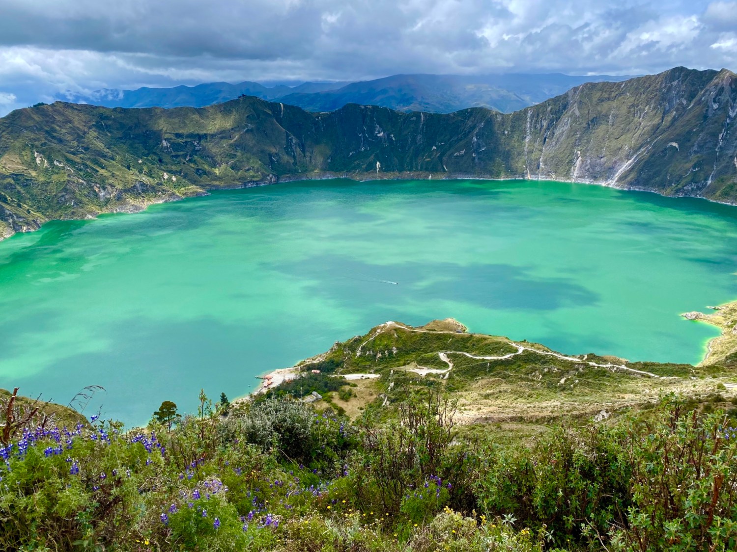
In August, I: Continued explorations of Ecuador with Mike. Imbibed in churros & chocolate at Dos Chorreras Chocolateria, where we found a shiny red car piled with chocolates and a disco ball overhead. Climbed the tower of the New Cathedral of Cuenca for views over its iconic Czech blue-tiled domes, Parque Calderón, and the city. Enjoyed an off-beat dinner at Consuelo, topped off by the strange dessert concoction of merengue and ice cream cones called Espumilla. Visited the Museo del Sombrero de Paja Toquilla to learn about the Panama hat. Experienced a beating at the hands of limpias, powerful women who clean out bad energy from the soul, at Mercado 10 de Agosto. Visited the Homero Ortega Hat Museum and bought a vintage Panama hat after picking up our rental car, a Toyota Yaris, from the airport. Ventured to Parque Nacional Cajas, where we hiked around Laguna Toreadorra amidst spongy mosses, succulents, Polylepis trees, and cacti in the high grassland known as páramo. Learned about the ancient Incan and Cañari cultures, and the various ethnic groups of Ecuador at the Pumapungo Museum in Cuenca. Ate cuy (guinea pig) at Guajibamba and then enjoyed dessert on the rooftop terrace of Negroni while admiring the blue domes of the New Cathedral. Bought yet another Panama hat! Drove up the Pan American highway to Ingapirca where we climbed the Temple of the Sun and learned about the Incas and Cañaris. Took a 45-minute loop hike to see Cara del Inca (a cliff with a human face) and drank Chicha de Jora, a corn beer. Enjoyed our stay at our first hacienda, Posada Ingapirca, where we shivered all night and in the cold morning shower. Enjoyed a city celebration and parade in Riobamba and ate tapas at Amona, while children stood outside the locked door gesturing for handouts (hands to mouth). Drove to Baños, a total waste of time. Felt disappointed that our biking guide, who we’d booked to take us biking down Volcán Chimborazo, got Covid and had to cancel. Drove up to Chimborazo anyway on a sunny day and had magnificent views of the symbiotic clouds caressing the volcano, and of the elegant vicuña (wild relatives of the llama). Drove from our adorable Hostal Huasicama in Latacunga to Tigua, where we bought bright paintings of Andean life, to Laguna Quilotoa, a volcanic crater lake. Hiked down the steep gravelly trail to the bottom, slipping and sliding the whole way, and then had to wait a long time for a donkey and horse to take us back up (I was having trouble breathing due to elevation). Hiked around Laguna Limpiopungo at Parque Nacional Cotopaxi in the cold and rain. Enjoyed the festive atmosphere at Hacienda Los Mortinos with its groups of Dutch tourists; finally warmed up when staff lit the woodstove in our room. Rode my horse, Dorado, with guide Edizon and Mike into Cotopaxi park, where all three of us were pelted with freezing rain and only had views of the volcano once the clouds lifted. Nearly fell off my horse when he decided to jump a stream rather than wade through it. Explored the lovely Hacienda Cusín, once a working ranch but now a hotel with exquisite grounds and interiors, near Otavalo. Stayed at the Las Palmeras Inn in Otavalo, another hacienda, and spent much of Saturday shopping at the Otavalo market, the largest market in Ecuador and the largest market of its kind in South America. Flew to Miami, where we spent the night, and then homeward on an early morning flight. Celebrated Alex’s completion of his semester with a dinner at Artie’s. Bid adieu to Alex as he moved into a house with some old friends in Alexandria (not far from where we live). Rode my bike, did yoga, walked, went to the gym, and started booking our trip to the Canadian Maritimes. Saw Emily the Criminal and Anne of Green Gables (in preparation to visit Prince Edward Island). Read 4 books out of my goal of 55 for the year (bringing my total to 42/55), my favorite being Rules for Visiting. Continued our perpetual mourning for the loss of 1,043,838 people in the U.S., and 6.49 million in the world, from two+ years of COVID.


In September, I: Walked, did yoga, rode my bike, and went to the gym in the never-ending battle to keep the pounds at bay. Got my bivalent COVID booster (#5 shot), which is supposed to protect against omicron and other variants. Celebrated my sister-in-law’s birthday at L’Auberge Chez Francoís, reviving a long-neglected family tradition. Walked with Poonam on the Glade Trail and when she fell and couldn’t get up, felt helpless to pull her up by myself. Mourned the death of Queen Elizabeth at 96 in sympathy for my British friends. Ate soup dumplings at Yu Noodles, and tried Padack at Seven Corners for the first time. Went to the Middle East Institute Art Gallery to see “More Than Your Eyes Can see: Contemporary Photography from the Arab World,” then enjoyed excellent grilled pulpo (octopus) and Tostones con salsa de mango at Del Sur Café in D.C. Visited my ailing father in Yorktown and met Sarah at Brambly Park Winery, where we had a huge falling out. Started physical therapy for pain in my right hip. Headed for Nova Scotia, Canada only to find out that the Category 4 Hurricane Fiona was heading that way. Picked up Mike at the Halifax airport just in time for us to hunker down in our Airbnb while Hurricane Fiona blew through overnight. Lost power for two days because of the storm. Drove an hour southwest to Mahone Bay to find coffee since no place in Halifax had power. Wandered around the colorful UNESCO town of Lunenburg and explored the fishing village of Blue Rocks, “Lunenburg’s answer to Peggy’s Cove.” Enjoyed our first fish cakes and seafood chowder at the Salt Shaker Deli. Clambered around the rocky coastal shelf at Peggy’s Cove and admired its stalwart lighthouse along with hordes of tourists. Enjoyed the amazing costal views and colorful vegetation as we hiked at Polly’s Cove. Paid respects to the victims at the SwissAir Flight 111 Memorial from the 1998 crash in St. Margaret’s Bay. Enjoyed mussels, chowder, and Digby scallops at Bluenose II Café in Halifax and then strolled along the lively waterfront boardwalk. Learned about Halifax history at the Maritime Museum of the Atlantic, including the 1912 Titanic sinking, the 1917 Halifax Explosion, and the huge numbers of shipwrecks off the shore. Enjoyed beer and whiskey and poutine at The Old Triangle, where the talkative waitress gave us a list of recommended spots to see. Drove to the Annapolis Valley and the Minas Basin, where we walked along the bay floor at low tide at Blomidon Provincial Park. Enjoyed a picnic lunch at Hall’s Harbour and then did a wine tasting at Domaine de Grand Pré. Enjoyed my first lobster roll at McKelvie’s in Halifax. Walked the Pennant Point Trail past the naturist Crystal Crescent Beach, but it was too cold to see any nude bathers. Admired the folksy paintings of Maud Lewis at the Art Gallery of Nova Scotia. Imbibed in tequila and tacos at Antojo Tacos & Tequila after having beers at the Beer Garden. Strolled the boardwalks through breezy marshes at the Sackville Waterfowl Park. Went from our new apartment in Saint John, New Brunswick to hike the Laverty Falls trail at Fundy National Park. Had an argument with Mike about books over Indian food at Thandi and then gave the waiter grief about his patriarchal attitude. Sadly finished one of our favorite TV series, The Bridge. Saw Mrs. Harris Goes to Paris at Cinema Arts Theatre. Finished 2 books out of my goal of 55 for the year (bringing my total to 44/55), my favorite being Born a Crime by Trevor Noah. Continued our perpetual mourning for the loss of 1,053,412 people in the U.S., and 6.53 million in the world, from two+ years of COVID.


In October, I: Continued exploring New Brunswick, Canada with Mike. Saw the strange phenomenon of the Reversing Falls at Saint John, where the strong Fundy tides rise higher than the water level of the Saint John River twice each day and appear to reverse the rapids. Walked around the unimpressive Container Village at the Saint John waterfront. Drove across a sand bar to Ministers Island and had to get off the island by 2:00 to avoid being stuck there by the tides. Wandered around the adorable St. Andrews by-the-Sea where I bought a fisherman’s hat and earned the nickname of “Roscoe” from Mike. Explored the sea bottom at low tide at Hopewell Rocks Provincial Park, and admired the “Flowerpot Rocks” there; they would be partially underwater at high tide. Enjoyed lobster rolls and a lazy lobster dinner at Alma Lobster Shop. Returned to Hopewell Rocks the next day, too late to see the rocks at high tide. Drove the 8-mile long Confederation Bridge over the Northumberland Strait. Met my old friend Lisa, who I studied Arabic with in Egypt in 2007, in Sea View, Prince Edward Island. Went on a ride in Lisa’s truck to meet her friends and then to see her favorite sights: Black Horse Corner, Park Corner Heritage Cemetery, the New London Lighthouse and the Cape Tryon Lighthouse, French River, and the red sand beaches. Enjoyed two fabulous breakfasts and dinners by Lisa, one of which included an early Canadian Thanksgiving dinner. Rode electric bikes around Charlottetown and for a bit along the Confederation Trail. Found much of Prince Edward Island National Park shut down because of trees felled by Hurricane Fiona. Visited Green Gables, the inspiration for L.M. Montgomery’s Anne of Green Gables, and was surprised to discover her love of fashion and her scrapbooking passion. Drove back across the Confederation Bridge and then the U.S. border to Brunswick, Maine. Had a horrible endless day driving home from Maine, encountering multiple traffic delays and detours due to heavy traffic on the Friday before the Columbus Day weekend. Continued physical therapy for the pain in my right hip. Found out my daughter was heartbroken over the death of her cat, Chicken Little, died. Ate sushi at Ariake and enjoyed an early 67th birthday celebration at Artie’s with Alex and Mike. Rode my bike for 11 miles on my Tuesday birthday. Met our friends Karen and Michael for dinner and drinks at Tiki Thai. Got my flu shot and second pneumonia vaccine. Voted early, blue all the way. Saw a student production of Head Over Heels at Center for the Arts at George Mason University. Drove to western Virginia to browse at the adorable Old Luckett’s Store (“Vintage Hip”) and enjoyed a giant chili dog and blackberry smash at Flying Ace Farm and Distillery. Was heartbroken to hear of the horrible crowd crush in Itaewon in Seoul, South Korea, where over 150 young people were killed while celebrating Halloween. Started watching the new season of White Lotus and got Apple TV+ so we could finally watch Ted Lasso. Watched Rear Window, Norwegian Wood, Notorious, Little White Lie, Ticket to Paradise, and That’s Amor. Finished 3 books out of my goal of 55 for the year (bringing my total to 47/55), my favorites being In the Field by Claire Tacon and Anne of Green Gables by L.M. Montgomery. Continued our perpetual mourning for the loss of 1,070,264 people in the U.S., and 6.59 million in the world, from two+ years of COVID.


In November, I: Continued physical therapy on my right upper hip; studied Spanish on Duolingo; planned and booked our upcoming trip to Nicaragua & Costa Rica. Enjoyed soup dumplings at Yu Noodles and injera with lentils and veggies at Enatye Ethiopian with Mike and Alex. Went to the Renwick Gallery for our 34th (27th) anniversary to see “This Present Moment: Crafting a Better World,” and enjoyed pulpo and the Latin American vibe at Del Sur Café. Visited my bedridden dad in Yorktown, and felt sad to see him wasting away despite continuing to eat. Had a 29th birthday celebration with our son’s girlfriend, Jandira, who we finally met after 8 months. Had a lovely Thanksgiving with almost the whole family here: Sarah, Alex, Jandira and Mike’s sister Barbara – everyone except Adam, who is still in Nicaragua and who we’ll see in late December. Spent Thanksgiving Day, after eating a huge feast, playing Codenames and Monopoly Deal. Walked daily but missed out on yoga due to PT sessions. Read 4 books out of my goal of 55 for the year (bringing my total to 51/55), with my favorite being Bodies of Water by T. Greenwood. Started watching the second season of The White Lotus and the fifth season of The Crown. Mourned the loss of 1,079,197 people in the U.S., and 6.6 million in the world, from two years & eight months of COVID.


In December, I: Visited the Hirshhorn Museum & Sculpture Garden to see “One with Eternity: Yayoi Kasuma in the Hirshhorn Collection.” Discovered other interesting and disturbing works in our wanders through the museum, including one on Contemporary Photography in China, in which protest art attempts to reclaim what was lost in the Cultural Revolution and tries to reckon with the recent past. Ate dinner in Arlington at Buena Vida Gastrolounge. Wished our son in Nicaragua a happy 30th birthday on Pearl Harbor Day. Finished up physical therapy on my right hip. Had a nice long talk with my friend Jayne in California. Celebrated as Alex graduated from Northern Virginia Community College and got officially accepted into George Mason University to continue his Computer Science degree. Saw Empire of Light at Cinema Arts Theatre followed by a delectable Vietnamese dinner. Went with Alex and Mike to Washington National Cathedral to see the annual display of creches and to eat our traditional lunch at the Lebanese Taverna Market. Felt heartbroken that my father passed away on December 18 after a years-long decline from strokes and Alzheimer’s, and after having become totally bedridden for the last year. Had a Zoom call with my siblings to toast my dad since he specified that he didn’t want any kind of funeral, although we’ll have a celebration of life in January or February. Enjoyed a Christmas celebration with Alex and Jandira, Mike and Barbara topped off by a game of Ticket to Ride. Took an early morning flight to Managua, Nicaragua to visit our son, Adam. Climbed Cerro Apante in Matagalpa to see views of the city and the huge Virgin Mary statue. Visited the Selva Negra coffee farm and learned about revolutionary leader Carlos Fonseca. Tried Nicaraguan street foods with Adam’s guidance: buñelos, respado, atol, and unripe mangoes with salt, lime & chili. Climbed to the roof of the Catedral de León and walked through the decrepit Museo de Revolución. Sunned and body-surfed at Playa Las Penitas on the Pacific coast, and then visited León museums in the afternoon: the Museo Rubén Dario and the Centro De Arte Fundación Ortiz-Gurdian. Ate a delicious New Year’s Eve dinner at El Bodegón in León, although I didn’t stay up to see in the New Year. Read 7 books out of my goal of 55 for the year (bringing my total to 58/55), with my favorites being Make Your Home Among Strangers by Jennine Capo Crucet and The Year of Fog by Michelle Richmond. Finished the second season of White Lotus. Mourned the loss of 1,090,204 people in the U.S., and 6.678 million in the world, from two years & ten months of COVID.


Here are some of my previous years’ recap posts. I now wish I had one for every year of my life, as they serve as great reminders of my adventures, joys, challenges, and tribulations in years past!
- twenty twenty-one: from insurrection to omicron
- twenty-twenty: the year of coronavirus
- twenty-nineteen
- twenty-eighteen
- twenty-seventeen
- twenty-sixteen
- Sadly, I didn’t do one in 2015.

- twenty-fourteen
- twenty-thirteen
- weekly photo challenge: my 2012 in pictures
Here’s wishing everyone a Happy New Year in 2023! 🙂


You must be logged in to post a comment.