After leaving Cheyenne, Wyoming we drove directly to “Colorful Colorado.” We passed metal sculptures of bison on a hilltop and had a view of the Rockies. We stopped briefly at the Visitor Center in Fort Collins and then took the scenic route to the Alpine Visitor Center at Rocky Mountain National Park.

Sculpture at the Fort Collins Visitor Center
We passed the Horsetooth Reservoir near the town of Stout, population 47 1/2. At Horsetooth Mountain Park, we picked up trail maps for a hike we planned to do the following day.


We drove past the “Masonville Mercantile: A Want & Wish Store” and the Bobcat Ridge Natural Area, passing a sign that said DR. BOB’S SNAKE OIL CURES ALL.


On 34W, we were welcomed to… Sylvan Dale Ranch (guest ranch, weddings, horsebackriding), but we continued on.
The Big Pipe was a canyon of rocky cliffs dotted with pine trees. We took a road along the Big Thompson River. The Big Pipe carries water to Horsetooth Reservoir. This is the entrance to the Rocky Mountains by way of the Big Thompson River Canyon.
We passed the Colorado Cherry Company, the Snowy Silver Lodge and Drake. A sign warned of Open Range Livestock on Road. By 11:20, it was 65°F, and yellow cottonwoods gilded the forests. On the north-facing side, the pine trees squatted in dark dense clusters.
There was the Glen Haven General Store, an alpine meadow, and the Lumpy Ridge Trailhead. MacGregor Ranch (1873) boasted of “Grass-Fed Beef.” We sailed past the Black Canyon Inn and before we knew it, we were in Estes Park, gateway town to Rocky Mountain National Park. We saw Dick’s Rock Museum, Coffee on the Rocks, Lazy R Cottages, Sticks & Stones Home Furnishings, and Bird & Jim Colorado Cuisine.
Prohibitions abounded: Hunting Prohibited. Collecting Antlers Prohibited.
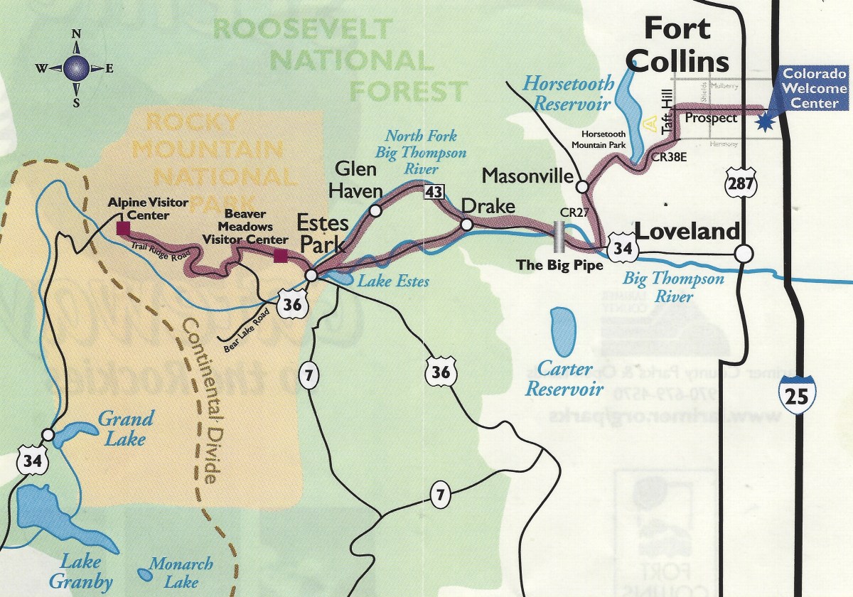
Our route today. Map from a pamphlet distributed by the Fort Collins Convention & Visitors Bureau and the Colorado Welcome Center: “Experience the Scenic Gateway to the Rockies.”
Just before noon, we arrived at Rocky Mountain National Park and the Beaver Meadows Visitor Center.
The Rocky Mountains form one of the world’s longest ranges, stretching almost unbroken from Alaska to below the nation’s southern border. Since 2009, Congress protected most of Rocky Mountain National Park as wilderness under the 1964 Wilderness Act. The designation protects forever the land’s wild character, natural conditions, opportunities for solitude, and scientific, educational and historical values.
Thrust up by earth’s forces 40-70 million years ago, then sculpted by multiple glacial episodes, the Rockies are “new” in geologic terms.
We entered the park through the montane ecosystem (below 9,000 feet). On warmer south-facing slopes, Ponderosa pines grow. Trees here are tall, up to 150 feet, and along with chokecherry, currant and juniper bushes, nourish many animals, insects and birds: beavers, otters, and elk. On cooler north-facing slopes, forests are dense with Douglas fir and lodgepole pine.
We drove up the Trail Ridge Road, past Beaver Ponds, where we got out to walk a short trail. Beaver dams once blocked the stream flows here, creating a pond. Silt and rich organic debris carried down from Hidden Valley accumulated behind the dam. In time, the dams decayed, draining the ponds and leaving fertile soil over 20 feet deep.
Sedges and grasses grow in this newly established soil to form marshes. Lush meadows developed over time as tree seedlings invaded the open space creating a new subalpine forest of pine, spruce and fir trees.


At the Hidden Valley picnic area, we had a picnic lunch.
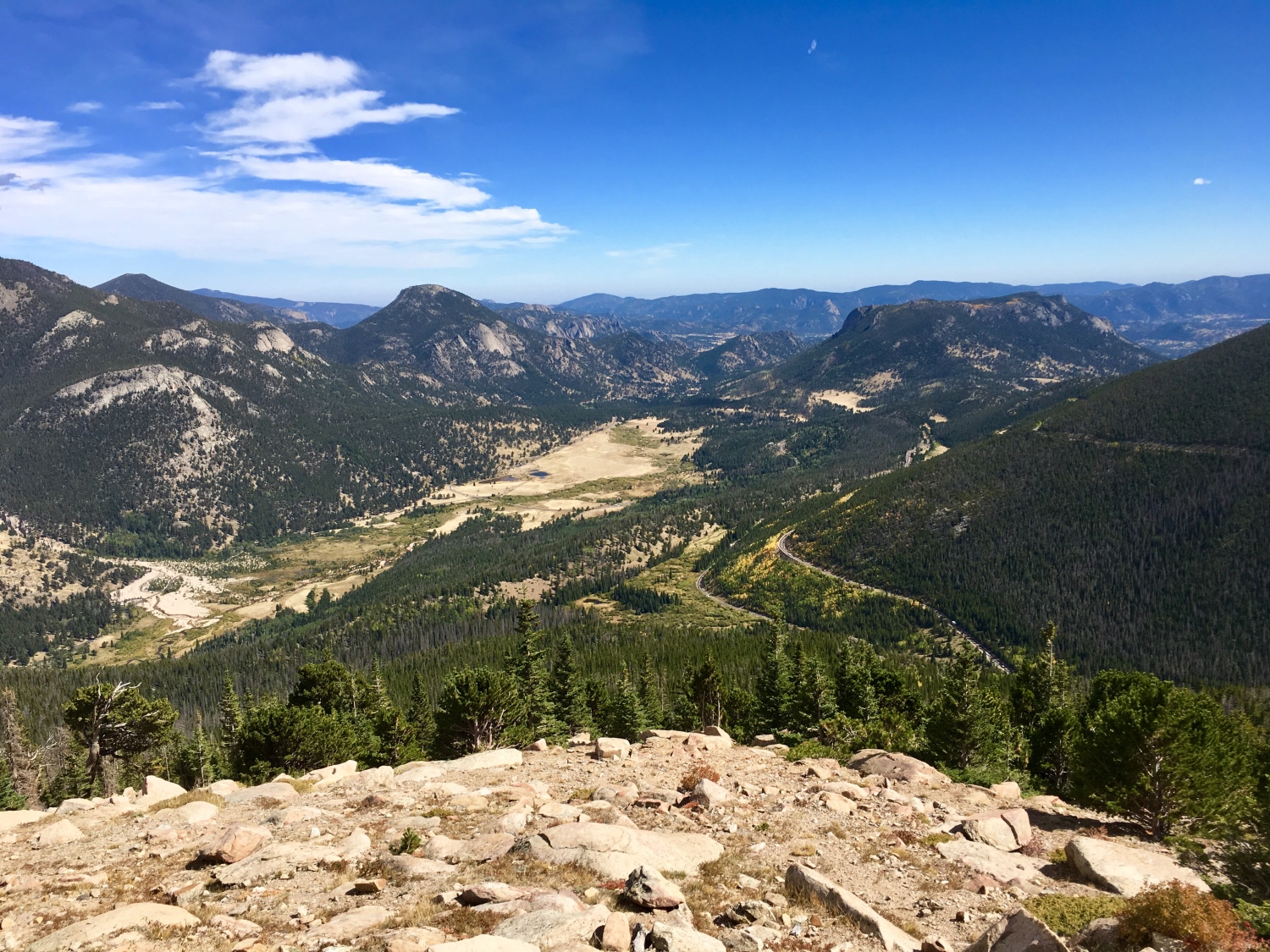
Then we stopped at Rainbow Curve Overlook to admire the landscape. Rainbow Curve is in the Subalpine part of the park (9,000-11,400 feet).
Snow that falls in the alpine zone blows down to the subalpine, creating a wet ecosystem with over 30 inches of precipitation annually. Engelmann spruce and flat-needled fir trees prevail, reaching 100 feet. The understory supports shrubs like blueberry, wax currant, huckleberry, and Wood’s rose. Wildflowers like arnica, fairy slipper, twinflower, and purple elephant’s head are abundant in open meadows.


We continued the drive up Trail Ridge Road. Forest Canyon lay to the south. Tall snow poles were in place along the road to show the way during big snowfalls. The Big Thompson River flows swiftly down Forest Canyon as it has for thousands of years. Several times during the past two million years, frigid climates caused glaciers to form and move down the canyon. Flowing ever so slowly, these deep “rivers of ice” carved out Forest Canyon along an ancient fault line.
We stopped at the Forest Canyon Overlook. At the higher elevation, the temperature had dropped to 56°F.
The subalpine forest ecosystem of Forest Canyon is abundant with life. Difficult to access through fallen trees and steep terrain, Forest Canyon furnishes protected habitat for hundreds of plants and animal species – from elk herds to microorganisms.
A short trail here crossed the tundra – a Russian word for “land of no trees.” Here above the treeline, winds often exceed 100 mph (160 km per hour) and temperatures remain below freezing for at least five months each year.


We stopped at the Lava Cliffs Overlook.


We crossed the highest point on the road at 12,183 feet (3,713 meters).
We finally reached the Alpine Visitor Center. Alpine Tundra (above 11,400 feet) is a fragile world, characterized by extremely thin soil, drying winds, and bitter cold. Many plants hug the ground in dense mats (avens), preserve moisture with waxen leaf surfaces, or trap warmth against stems and leaves with hairs. Animals must adapt or die.
There in the crowded parking lot, I had an altercation with a guy. The wind was blowing like there was no tomorrow and when I opened my car door, he yelled “Hold on to your door so it doesn’t hit my car!” (I was already holding it, and the door didn’t hit his car). I said, “Rudeness personified. That guy is an asshole,” (talking to Mike but saying it loud enough for him to hear). He said, “Some guy messed up my car with his door.” I replied, “Well, don’t take it out on me!”
I can’t stand bullies.
We walked up along the Alpine Ridge Trail in the midst of a fierce and relentless bitter wind. This trail is affectionately known as “Huffers Hill,” because it takes your breath away. We walked through a delicate yet hardy environment.
The scattered rocks form “patterned ground” that is found only in Arctic and Alpine regions where temperatures remain below freezing at least five months each year. During the last Ice Age, freezing and thawing of this tundra topsoil forced these patterns to the surface.
Some patterned ground has indistinct forms, while others are precise circles or other forms. The degree of slope determines the rock patterns. Rock streams “flow” downhill on Sundance Mountain in the distance, while polygons and circles form on level surfaces.


Leaving the Alpine Visitor Center, we retraced our drive up and stopped at the Gore Range Overlook. We could have gone further west and south on Trail Ridge Road, but we needed to return to Fort Collins to meet our son.
The Gore Range was named for Sir St. George Gore, an Irish aristocrat who was led there on a hunting expedition in 1854 by mountain man Jim Bridger. In 1976, Congress set aside 133,000 acres of the Gore Range as Eagles Nest Wilderness Area, which remains nearly as wild today as when Gore and Bridger first entered it.


We stopped again at Forest Canyon Overlook. This time, we walked to the other side of the road.


We made our way slowly to lower elevations, back to the montane ecosystem. The yellow trees on the mountains were glowing in the afternoon sunlight.


On the way back, we forked off at the Deer Ridge Junction and stopped briefly at Sheep Lakes.


This time, we stopped at the Fall River Visitor Center. Here are my cancellation stamps for Rocky Mountain National Park.
(Information about Rocky Mountain National Park is from National Park Service pamphlets and signs.)
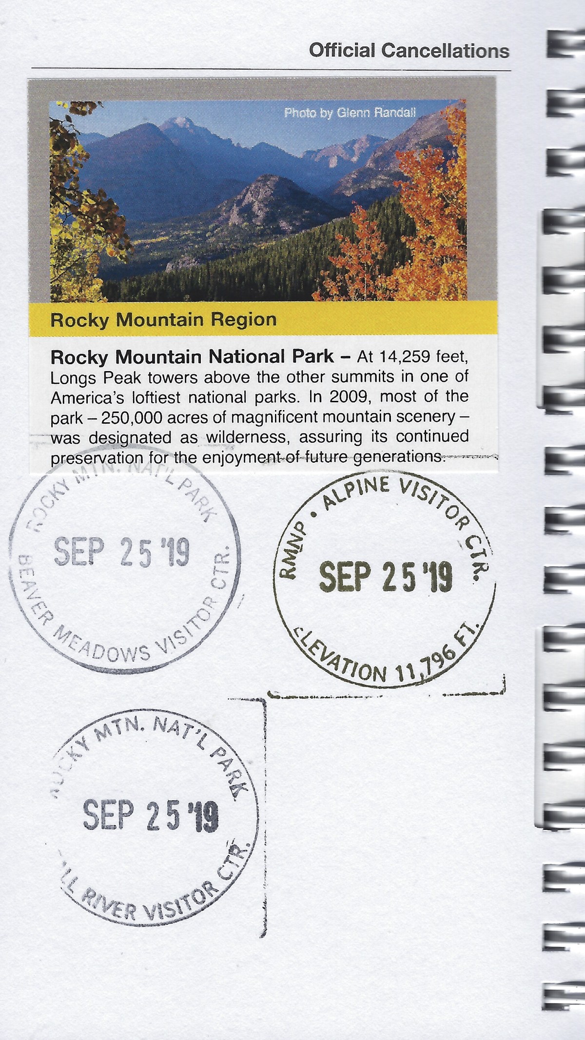
cancellation stamp for Rocky Mountain National Park
On our way to Fort Collins, where we would meet our son Alex and spend the night, we passed God’s Country Cowboy Church. Someone had a bumper sticker that said, “I brake for wildflowers.” I liked that.
In Fort Collins, we stayed in a strange little place called Solarium. As the guy gave us a tour of the place, he showed us the tent and outdoor area where we were allowed to smoke cannabis, but this privilege was wasted on us, as we don’t do that stuff.


When Alex arrived in Fort Collins, we went into the town to have dinner at Restaurant 415.


We spent the night in Solarium; the next day, we’d head to Denver after hiking the Arthur’s Rock Trail at Lory State Park.
*Steps, 12,735, or 5.4 miles*
*Wednesday, September 25, 2019*
Discover more from ~ wander.essence ~
Subscribe to get the latest posts sent to your email.

Nice captures and a great post Cathy🙂
LikeLike
Thank you so much! 🙂
LikeLiked by 1 person
Beautiful photos, Cathy. Did you get a chance to go on Old Fall River Road? It was the first auto route in RMNP and omg, it’s harrowing in some ways. Gravel, steep, no guard rails.
LikeLike
Thank you, Robin. No, we didn’t go on Old Fall River Road. I’m sure we missed a very exciting and harrowing adventure!
LikeLiked by 2 people
Lovely! We did go here and stayed a couple of nights. We drove up the old road described by the last commenter and back down the road you used. We also climbed Deer Mountain, happy memories!
LikeLike
Yes, you can only go UP Old Fall River Road; we didn’t have time to take it, sadly. I see the Deer Mountain Trailhead on the map, but sadly we missed that too. I’m glad you had happy memories there!
LikeLiked by 2 people
Oh, this scenery!
LikeLiked by 1 person
Thanks, Carol. We thought it was pretty amazing. 🙂
LikeLiked by 1 person