I never did a year-end recap for 2015, so here is that year recreated for my records. 🙂
In twenty-fifteen, I: Finished my first semester teaching English at Sino-Canadian International College of Gaungxi University. Traveled with Mike to Fenghueng, Zhangijiajie, Guilin and Yangshuo in China, where it was cold and rainy nearly every day and we both got sick. Sent Mike home to the U.S. and exchanged him for Alex. Traveled with Alex to Yunnan Province: Kunming, Lijiang, Dali, The Stone Forest, Jade Dragon Snow Mountain, Baisha, Shuhe, and Shaxi. Went to Myanmar where I visited pagodas aplenty in Mandalay, Bagan, Inle Lake and Yangon. Continued teaching English and traveling all over China, to Hong Kong, Xi’an, Shanghai, Yangshuo, the Longji Rice Terraces and Beihai. Returned to the U.S., stopping in California to visit my sister Stephanie and the Channel Islands, and to go with Rosie to Joshua Tree National Park. Finished my CELTA course in D.C. in late October. Went with Mike to Assateague Island and Chincoteague National Wildlife Refuge to celebrate my 60th birthday. Celebrated Mike’s and my 27th (20th) anniversary at Shepherdstown, WV and Antietam National Battlefield. Visited my dad and stepmother in Yorktown after Christmas. Read 13 books out of 30: My 2015 Reading Challenge.
In January, I: marked 73 writing final exams in a 30-hour marathon after classes ended at Guangxi University. Watched marathon sessions of the final season of Breaking Bad in between marking and invigilating for exams. Greeted Mike at Nanning Airport for his two-week holiday in China. Took an overnight train to Jishou in Hunan province, where Mike and I shared a compartment with two young men constantly glued to their phones and where Mike was shocked by the holes in the floor of the train that served as toilets feeding directly onto the railroad tracks. Ate pork dumplings and boiled eggs in Fenghuang (Phoenix Ancient Town) every morning with our favorite vendor. Climbed 99 steps at Jiujiu Heaven Steps to the magical Phoenix Fairy Tale, where we hung Phoenix wish-making cards to the dozens of parasols, clapped our palms, closed our eyes and purified our hearts so our wishes would come true. Was serenaded by a young Chinese lady singing melodic Chinese folk tunes at Soul Café. Saw numerous restaurant signs refusing entry to Japanese and dogs. Tried on a military costume for a photo-op, looking like some member of the Russian military. Traveled by another train to Zhangjiajie and took a boatride around Baofeng Lake. Used my WayGo app to translate menu items at restaurants. Spent two days in steady rain, heavy fog and biting cold walking around Zhangjiajie National Forest Park, barely able to see the almost 3,000 karst formations (tall quartzite sandstone pillars) that were the inspiration for the movie Avatar. Spent the first day walking along Golden Whip Stream in a deep canyon surrounded by cliffs and peaks. Marveled at the names of the peaks such as Splitting Mountain to Save Mother, Monkey Playing in the Chinese Yew Grove, and Pigsy Looking in the Mirror. Tried to get warm in evenings by soaking in the nice hot bath at our hotel. Took the Bailong Elevator to the heights of the park with a guide on our second day, with the weather being colder, foggier and rainier than the first day. Couldn’t even see the outline of the so-called Avatar Mountain because of the fog. Watched an acrobatics and dance show called “Charming Western Hunan,” which wasn’t as impressive as others I’d seen. Watched a barefoot man walking along the sharp edge of a curved sword, terrified to watch in case he fell and was cut in half vertically! Took a flight to Changsha, the capital city of Hunan, and arrived in Guilin where we stayed in the Guilinyi Royal Palace. Took a bicycle ride through the countryside in Yangshuo on another cold and cloudy day with a guide, Esther; on the way back it rained steadily, drenching us, and I felt a sore throat and cold coming on. Took a dark and gloomy boat ride down the Li River, and eventually got rained on. Found myself sick with a miserable cold; Mike also got sick. Got couple massages on another rainy day and stayed inside our room, reading, sleeping, snacking and talking. Escaped Yangshuo, driving through kumquat orchards, visiting the Seven Star Green Tea Plantation where we enjoyed a tea ceremony, and climbing up Xianggong Hill for overcast views of the karsts along the Li River. Pampered myself with our creature comforts, as did Mike, back at the Guilinyi Royal Palace after strolling through the botanical gardens. Returned to Nanning, where we continued to be sick; we only ventured out to eat some pizza.

Mike eats dumplings in Nanning

me at my dumpling spot in Nanning

our breakfast spot in Fenghuang

Fenghuang

Fenghuang (the phoenix)

Fenghuang

me in military costume in Fenghuang

Fenghuang

Fenghuang

our breakfast lady in Fenghuang

Fenghuang

Fenghuang

Fenghuang

Fenghuang

Fenghuang

Fenghuang

Fenghuang

Fenghuang

Fenghuang

Fenghuang

Fenghuang

Fenghuang

Fenghuang

Fenghuang

Fenghuang

Fenghuang

Fenghuang

Fenghuang

Zhangjiajie

Zhangjiajie

Zhangjiajie

Zhangjiajie

Zhangjiajie

Zhangjiajie

Zhangjiajie

Zhangjiajie

Zhangjiajie

Zhangjiajie

Zhangjiajie

Zhangjiajie

Zhangjiajie

Zhangjiajie

Zhangjiajie

Zhangjiajie

Zhangjiajie

Zhangjiajie

Zhangjiajie

Zhangjiajie

Zhangjiajie

Zhangjiajie

Zhangjiajie

Guilin

Guilin

Yangshuo

Yangshuo

Yangshuo

Yangshuo

Yangshuo

The Li River

The Li River

The Li River

The Li River

Yangshuo

Seven Star Green Tea Plantation

Seven Star Green Tea Plantation

Seven Star Green Tea Plantation

views of the Li River

Me with Mike above the Li River

karsts around Yangshuo

The Li River

The Li River

The Li River

The Li River

Guilin

Guilin

Guilin
In the first half of February, I: Took Mike to my favorite Korean restaurant in Nanning before taking him to the airport, where I exchanged him for Alex. Ate dumplings at the Red Sign with Alex, and the next day flew with him to Kunming in Yunnan Province. |*Yunnan Province*| Visited The Bamboo Temple dedicated to Zen Buddhism with its painted sculptures of the 500 Buddhist arhats (“perfected people”). Wandered around the World Heritage-Listed town of Lijiang, admiring its many shops and cultural assets. Listened to the Naxi Orchestra’s slow and haunting Song Dynasty tunes (for example “The Bound-Foot Girl Song” and “The Song of a Water Dragon”) played on antique instruments. Took oxygen cans to the top of the crowded Jade Dragon Snow Mountain via a 3km-long cable car, where we enjoyed magnificent views of the range which resembled a jade dragon lying in the clouds. Almost lost Alex at Mirror Lake in Blue Moon Valley, had a huge fight with him about his attitude regarding the crowds in China, and then made up over a lovely dinner. Visited Mu’s Mansion and climbed to the top of the Lion Hill Scenic Area, which supposedly looks like a crouching lion, and admired the Wangu Pavilion, a 5-storied wooden pagoda-styled building. Visited Baisha Ancient Town where we saw the historic Baisha Frescoes (1385-1620). Wandered aimlessly through the quaint town of Shuhe, with its weeping willows reflected in streams running through the streets, red lanterns and yellow flags. Had to use the dreaded trough-like toilets at the bus station on the way to Shaxi, a town that once was a busy trade station on the Tea and Horse Caravan Road, an important branch of the southern Silk Road. Took a fabulous bicycle ride to White Dragon Pool, where, in attempting to descend, I fell face down into a briar patch and got a nasty scrape on my calf. Visited the Buddhist Heavenly Wings Hall with paintings representing Tantric Buddhism. Visited Shibao Shan, or Stone Treasure Mountain, where I found my favorite temple, the Baoxiang Temple, or “Suspending Temple,” built on the ledge of a nearly vertical cliff. Met new statues of Guanyin and Maitreya, the smiling Buddha, on the cliff ledges. Took a bus to Dali, a haven for cool Chinese tourists and foreign backpackers, considered “China’s closest approximation to bohemia.” Enjoyed foot massages with Alex then visited a clinic for some antibiotics for an ear infection. Took another bikeride to Erhai Lake (“Ear-shaped Sea”) and then visited the Three Pagodas of Dali. Flew back to Kunming and visited Yuantong Temple, Yunnans’ grandest and most important Buddhist site, built during the late 8th and early 9th centuries. Visited the Stone Forest in Shilin, full of karst formations known as stone forest (higher karsts) and stone teeth (shorter karsts). Visited the Yunnan Nationalities Museum in Kunming, including the fabulous Tibetan Buddhist Lamasery.

Lijiang

Lijiang

Naxi Orchestra

Jade Dragon Snow Mountain

Jade Dragon Snow Mountain

Jade Dragon Snow Mountain

me with Alex at Jade Dragon Snow Mountain

Jade Dragon Snow Mountain

Jade Dragon Snow Mountain

Mirror Lake

Mirror Lake

Mirror Lake

Mirror Lake

Baisha Frescoes in Baisha Ancient Town

Lijiang

Lijiang

Lijiang

Lijiang

Shuhe

Shaxi

bikeride to White Dragon Pool

bikeride to White Dragon Pool

Alex on our bikeride bikeride to White Dragon Pool

me with my bike bikeride to White Dragon Pool

bikeride to White Dragon Pool

Shibao Shan, or Stone Treasure Mountain

Shibao Shan, or Stone Treasure Mountain

Shibao Shan, or Stone Treasure Mountain

Shibao Shan, or Stone Treasure Mountain

Shaxi

Dali

bikeride to Erhai Lake

bikeride to Erhai Lake

Erhai Lake

Three Pagodas of Dali

Dali

Dali

Dali

Alex and I on the plane to Kunming

Yuantong Temple in Kunming

Yuantong Temple in Kunming

Yuantong Temple in Kunming

Yuantong Temple in Kunming

Yuantong Temple in Kunming

Yuantong Temple in Kunming

Alex at Yuantong Temple in Kunming

Stone Forest in Shilin

Stone Forest in Shilin

Stone Forest in Shilin

Stone Forest in Shilin

Stone Forest in Shilin

Stone Forest in Shilin

Stone Forest in Shilin

Stone Forest in Shilin

Stone Forest in Shilin

Stone Forest in Shilin

Stone Forest in Shilin

Stone Forest in Shilin

Stone Forest in Shilin

Stone Forest in Shilin

Yunnan Nationalities Museum in Kunming

Yunnan Nationalities Museum in Kunming

Yunnan Nationalities Museum in Kunming

Yunnan Nationalities Museum in Kunming

Yunnan Nationalities Museum in Kunming

Yunnan Nationalities Museum in Kunming
In the second half of February, I: Left our hotel in Kunming for the airport; from there I headed to Mandalay, Myanmar and Alex flew to Beijing and then home. |*Myanmar*| Caught a motorbike in Mandalay, Myanmar to see the Golden Palace Monastery and a pagoda known as the World’s Biggest Book, and then up a series of switchbacks to see sunset from Mandalay Hill. Rode with taxi-driver Meemo to Amarapura, “City of Immortality,” the royal capital in Myanmar for less than 70 years. Watched over 1,000 young monks collect their lunch at Maha Ganayon Kyaung with hordes of tourists. Bought several silk scarves at the Thein Nyo Silk Weaving Factory. Left my flip-flops behind at U Min Thone Sae Pagoda, in the first of many flip-flop incidents in Myanmar, and had to climb hundreds of steps to retrieve them. Took a horse cart ride with a belligerent young man who viciously beat his horse with a bamboo stick in Ava. Watched another sunset at the U Bein Bridge spanning Taungthaman Lake. Took a boat down the Ayeyarwady River to Mingun, relaxing into a pace of life I hadn’t experienced since childhood. With a young woman and man from Scotland and Britain respectively, took an ox-cart, with “Taxi” written on the roof, around Mingun, with its pagoda-studded hills. Visited the Mandalay Royal Palace, where I was reminded that I lose interest easily at sprawling abandoned places where kings once lived. Watched as “only men” applied gold leaf to the 13-foot-tall bronze Mahamuni Buddha. Was informed by Chen at Sino-Canadian International College that our paycheck for February would be delayed until mid-March, which infuriated me and lead to a slew of emails. Enjoyed immensely the 10-hour cruise down the Ayeyarwady River from Mandalay to Bagan. Sat in bamboo chairs on the ferry, talking with fellow travelers about our travels and watching the river go by, feeling like I’d gone back in time 50-100 years. Enjoyed a potato and pumpkin curry for my first meal in Bagan. Hired a car from the hotel to take me on day-long trip to see the most famous of the thousands of Bagan’s Buddhist temples. Poured water over the Tuesday (my birth day) Buddha image, saying a prayer. Enjoy a great view of the Bagan plain from the Bagan Viewing Tower. From Pyathada Paya, where I went to watch the sunset, saw a dust-kicking caravan consisting of cattle, tour buses, cars, SUVs, motorbikes, horse-drawn carriages, walkers and bikers from – reminding me how much I loved the blend of modern and traditional in Myanmar. Rented a mini-motorbike and rode off to see Bagan’s temples in my baggy pajama-like pants, almost wrecking the motorbike within the first few minutes. Left my favorite blue Havaianas at the entrance of the “many elephants temple,” and accidentally put on someone else’s blue flip-flops without realizing it. Noticed at Sulamani Pahto that the flip-flops I had on were flimsier and shinier than mine and wrongly assumed someone had taken mine by accident. Stopped back at the “many elephants temple,” and found my Havaianas alone in the dust, meaning I had taken someone else’s flip-flops, instead of the other way around. Went with a driver to Mt. Popa, where I had to climb 777 steps to the temple. Was stopped by a monopolizing shoe minder (who reminded me of the “Soup Nazi” in Seinfeld), but as I was tired of paying someone to watch my shoes everywhere I went, I stashed them in a hidden spot. Felt annoyed I had to walk barefooted through all the monkey poop left by the Macaque monkeys. Back at the shoe minder’s spot, I found my Havaianas had disappeared, and believed I had reaped bad karma for refusing to pay the shoe minder. Bought some uncomfortable bamboo soled flip-flops to replace mine, which I was convinced the shoe-minder had disposed of. Rented another motorbike and found delectable Butter Fish Curry and lime juice at the Black Rose Cafe. Had to call someone from the hotel to rescue me when my motorbike died. Took Asian Wings to Inle Lake and ate a savory crepe at Pancake Kingdom. Rode a bicycle to Red Mountain Estate Vineyards & Winery where I enjoyed a flight of wines in a lazy atmosphere. Enjoyed Paneer Curry at Everest with a Japanese girl I’d met in Bagan; she had been having the same problems with her motorbike as I was having. Took an all-day long-tail motorboat ride on Inle Lake where I saw Intha farmers, their stilt houses, and gardens and visited the five-day rotating market. Watched the Intha men wrap their leg around the paddle to propel the blade through the water in a snake-like motion. Visited the long-neck Padaung women, with brass coils around their necks, as they wove scarves at a weaving workshop. Enjoy another full day on the lake on the way to Inthein. Enjoyed Paneer Curry at Everest Nepali Restaurant and then an one-hour Aromatic Therapy full-body massage. Encountered thousands of Buddha figures at Shwe Oo Min Natural Cave Pagoda on the way to the Heho Airport. Followed a City Walk from Lonely Planet Myanmar through Colonial Yangon. Sent prayer cards up in a small golden karaweik (royal barge in the shape of a mythical bird) to a shrine higher up in the stupa, like sending prayers to heaven, or letters to Santa. Enjoyed a Camembert, walnut and toast salad at the Victorian-style Strand Hotel, on the Yangon City Heritage List. Got an hour-long foot massage for my aching feet and a shampoo and haircut. Walked around the Shwedagon Pagoda, “the Crown of Burma,” at sunrise. Was told at the post office that the Buddhas I bought, which I wanted to mail home to Virginia, couldn’t be taken from the country without permission from the National Museum or the Department of Archeology. Spent my last day in Yangon searching out this place on the outskirts of the city. Was told by the woman there to put the half-Buddha head (the back half had been cut off so it could hang flat on a wall) into my suitcase and was given an seal of approval on the reclining Buddha. Took off from Yangon for Mandalay and then returned to Nanning.

Mandalay, Myanmar

Mandalay

Mandalay

Mandalay

Mandalay

Mandalay

Mandalay

Mandalay

Mandalay

Mandalay

monks at Maha Ganayon Kyaung

monks at Maha Ganayon Kyaung

monks at Maha Ganayon Kyaung

Mandalay

Mandalay

Mandalay

Mandalay

Mandalay

Mandalay

Mandalay

Mandalay

Ava

me in Ava

our poor horse in Ava

boaters waiting for sunset at U Bein Bridge

U Bein Bridge

U Bein Bridge

U Bein Bridge

taking a boat down the Ayeyarwady River to Mingun

our driver in Mingun

Mingun

me in Mingun

me in Mingun

views of the Ayeyarwady River

Mandalay Royal Palace

Mandalay Royal Palace

taking a boat down the Ayeyarwady River to Bagan

taking a boat down the Ayeyarwady River to Bagan

taking a boat down the Ayeyarwady River to Bagan

taking a boat down the Ayeyarwady River to Bagan

taking a boat down the Ayeyarwady River to Bagan

Bagan

Bagan

Bagan

Bagan

me on my motorbike in Bagan

herd of goats in Bagan

Mt. Popa

Mt. Popa

Mt. Popa

Mt. Popa

me at Mt. Popa

Mt. Popa

Mt. Popa

Mt. Popa

Inle Lake

Inle Lake

Inle Lake

me at Red Mountain Estate Vineyards & Winery in Inle Lake

Inle Lake

Inle Lake

Inle Lake

Inle Lake

Inle Lake

Inle Lake

Inle Lake

Inle Lake

Inle Lake

Inle Lake

Inle Lake

Inle Lake

long-neck Padaung woman at Inle Lake

market at Inle Lake

Inle Lake

Intha farmer at Inle Lake

Inle Lake

Inle Lake

Inle Lake

Inle Lake

Inle Lake

Inle Lake

Shwe Oo Min Natural Cave Pagoda

Shwe Oo Min Natural Cave Pagoda

Shwe Oo Min Natural Cave Pagoda

Shwe Oo Min Natural Cave Pagoda

Shwe Oo Min Natural Cave Pagoda

Shwe Oo Min Natural Cave Pagoda

Shwe Oo Min Natural Cave Pagoda

Yangon

me in Yangon

colorful textiles in Yangon

Shwedagon Pagoda in Yangon

Shwedagon Pagoda in Yangon

Shwedagon Pagoda

Shwedagon Pagoda

Shwedagon Pagoda

Shwedagon Pagoda

Shwedagon Pagoda

Bogyoke Aung San Museum

Bogyoke Aung San Museum
In March, I: Visited Nanhu Lake Park in Nanning on a cloudy day then went to see a movie, Taken 3, with some of my students. Went to see the Guangxi Science and Technology Museum, which was more of an interactive place for children. Continued teaching my classes at Sino-Canadian International College, watched endless episodes of Scandal, and watched Kingsman Secret Service in the theater.

Guangxi University campus

Nanhu Lake Park in Nanning

Nanhu Lake Park in Nanning

Nanhu Lake Park

Nanhu Lake Park

Nanhu Lake Park

Nanhu Lake Park

Nanhu Lake Park

Nanhu Lake Park

Nanhu Lake Park

Nanhu Lake Park

Nanhu Lake Park

Nanhu Lake Park

Guangxi Science and Technology Museum

Guangxi Science and Technology Museum

Guangxi Science and Technology Museum

Guangxi Science and Technology Museum

Guangxi Science and Technology Museum

Guangxi Science and Technology Museum
In early April, I: Took a trip to |*Hong Kong*| on the three-day weekend for Qing Ming Festival, or Tomb-Sweeping Day, important for tending of family graves and ancestral worship. Crossed the border at Shenzhen with hordes of Chinese tourists taking advantage of the holiday weekend. Took the Big Bus Hong Kong on Hong Kong Island and then a Sampan ride at Aberdeen, a thriving fishing port. Ferried back to Kowloon, where I was delighted by a picturesque junk in Victoria Harbour. Strolled the Avenue of Stars, a tribute to Hong Kong’s film industry. Found tributes to Malaysian actress Michelle Yeoh Choo-Kheng (Crouching Tiger, Hidden Dragon) and Bruce Lee, one of the most influential martial artists of all time. Ferried again to Lantau Island where I visited the Po Lin Monastery and came face-to-face with the famous bronze Tian Tan Buddha, better known as Big Buddha, a 34-meter-high sculpture of the Sakyamuni Buddha sitting cross-legged on a lotus flower and looking north over the Chinese people. Was awestruck by the gorgeous and colorful Po Lin Monastery despite the stomach cramps I got from eating a lunch of vegetables smothered in oil. Took the Ngong Ping Cable Car, “Asia’s longest bi-cable ropeway” (at that time) over Lantau Island. Rode the Peak Tram to the top of Victoria Peak, where I found amazing views of Victoria Harbour, Hong Kong Central, Kowloon, the green peaks of the New Territories. Descended the Old Peak Road on foot and topped the day off with a Turkish dinner of lentil soup and fried halloumi cheese salad at Tava. Mustered up enough energy to visit the Night Market, where I found calligraphy brushes, Mao pictures, fans and jade statues and funny Chinese license plates: “My Favourite Wife” and “I’m not in the mood to-day don’t distrub (sic).” Met up with Peter, my dear friend Jayne’s husband (from whom she was separated) who lived in Hong Kong. Wasted my last day in Hong Kong due to the stomach issues that had plagued me my whole time in China.

Hong Kong Ferris Wheel

Sampan ride at Aberdeen

Sampan ride at Aberdeen

Sampan ride at Aberdeen

Sampan ride at Aberdeen

Sampan ride at Aberdeen

Sampan ride at Aberdeen

Sampan ride at Aberdeen

Sampan ride at Aberdeen

Sampan ride at Aberdeen

Kowloon

Victoria Harbour

Victoria Harbour

Victoria Harbour

Victoria Harbour

Junk in Victoria Harbour

Junk in Victoria Harbour

Avenue of Stars – Michelle Yeoh Choo-Kheng

Avenue of Stars – Bruce Lee

Tian Tan Buddha

around the Tian Tan Buddha

view from Tian Tan Buddha

view from the Tian Tan Buddha

view of Po Lin Monastery from the Tian Tan Buddha

Tian Tan Buddha

Po Lin Monastery

Po Lin Monastery

Po Lin Monastery

Po Lin Monastery

Po Lin Monastery

Po Lin Monastery

Po Lin Monastery

Tian Tan Buddha

Ngong Ping Cable Car

Ngong Ping Cable Car

view of boats from Ngong Ping Cable Car

view from Victoria Peak

view from Victoria Peak

view from Victoria Peak

view from Victoria Peak

view from Victoria Peak

view from Victoria Peak

descending the Old Peak Road

view from Victoria Peak

view from Victoria Peak

view from Victoria Peak

Night Market

Night Market

Night Market

Peter and me in Hong Kong

streets of Hong Kong

streets of Hong Kong

streets of Hong Kong
Later in April, I: Flew to |*Xi’an*|, the capital of Shaanxi Province, for the 4-day holiday, Zhuang Song Festival, a ceremonious festival for the Zhuang people and for many other ethnic groups. Visited the Xi’an Beilin Museum, also known as the Forest of Stone Steles, because it was raining steadily in Xi’an. Took a rickety three-wheeled taxi to the Small Wild Goose Pagoda, a Buddhist sculpture built during the heyday of the Silk Road, along with Jianfu Temple (Felicity Temple), both relics of the Tang Dynasty. Took a long walk to the Daxingshan Si, Xi’an’s only working Buddhist temple, where I found a frightening depiction of hell. Ate an Indian lunch that made me feel sick even as I was eating it, yet it was so delicious I ate it anyway. Visited the Daci’en Temple, home of the Big Wild Goose Pagoda, where I found fabulous views of Xi’an. Ate fried shrimp at a Pizza Hut near the Bell Tower, which sat at a major crossroads of the four major streets of the city. Visited the Museum of Qin Terra Cotta Warriors and Horses with a small group of tourists and “Chelsea,” our Chinese guide. Learned about the tyrannical emperor Qin Shi Huang, who set out to destroy all books except practical ones, unified the empire with a network of roads, and built the Great Wall; he died in 210 BC while on a quest to find the legendary island of immortals and their secret drug of longevity. Learned that the Terra Cotta Army and his mausoleum, which took 11 years to complete, reflected the workings of a paranoid mind filled with delusions of grandeur; it was estimated at one time that there were more than 8,000 soldiers, 130 chariots with 520 horses, and 150 cavalry horses Was awed by the sheer numbers of the warriors and the story behind them. Visited the Tomb of Qin Shi Huang, just an artificial hill. Visited Huaqing Hot Springs, considered to be medically beneficial, built in 723 by Emperor Xuanzong of the Tang dynasty. Ate delicious wide spicy noodles in Xi’an’s Muslim Quarter that only contributed to my stomach issues. Heard a drum performance at the Drum Tower. Was assaulted by colorful banners, food carts and stalls, along with the delicious smells of dumpling soup in Xi’an’s Muslim Quarter. Visited the Great Mosque, the largest mosque in China, established in 742 during the Tang Dynasty (618-907), with its Arabic motifs melded with Chinese designs. Finally ate the famous soup of the area, Yangrou Paomo, crumbled flatbread (unleavened bread) in mutton stew (I had mine with beef, which I removed); the bread turned into something between dumplings and späetzle, which was heavenly. Rode my bicycle around part of the perimeter of the 8-mile Xi’an City Wall on the only sunny day I had in Xi’an. Went with Mari, the Finnish lady I met on the tour of the Terra Cotta Warriors, to the Tang Dynasty Palace to see the Tang Dynasty Music and Dance Show, with its enchanting stage sets and the long and elegant sleeves of the dancers’ costumes, which floated dreamily and hypnotically throughout every dance. Flew to |*Shanghai*| on the last day of the month, the beginning of the three-day Labour Day holiday, where my flight was delayed by torrential rains, roaring thunder, vicious lightning strikes and howling winds. Arrived in Shanghai after midnight to the best hotel I’d had during my time in China, the Pentahotel, with a most comfortable bed and a bathtub, a rarity!

Xi’an Beilin Museum

Xi’an Beilin Museum

Xi’an Beilin Museum

Xi’an Beilin Museum

Xi’an Beilin Museum

Xi’an Beilin Museum

Small Wild Goose Pagoda

Small Wild Goose Pagoda

view from Small Wild Goose Pagoda

Small Wild Goose Pagoda

lush flower at Small Wild Goose Pagoda

Small Wild Goose Pagoda

messages at Small Wild Goose Pagoda

bell at Small Wild Goose Pagoda

Small Wild Goose Pagoda

Small Wild Goose Pagoda

Small Wild Goose Pagoda

Small Wild Goose Pagoda

Daxingshan Si

Daxingshan Si

Daxingshan Si

Daxingshan Si

Daxingshan Si

Daxingshan Si

Daxingshan Si

Daxingshan Si

Daxingshan Si

Daxingshan Si

Daxingshan Si

Daxingshan Si

Daxingshan Si

Daxingshan Si

Daxingshan Si

Daxingshan Si

Daxingshan Si

Daci’en Temple, home of the Big Wild Goose Pagoda

Daci’en Temple, home of the Big Wild Goose Pagoda

Daci’en Temple, home of the Big Wild Goose Pagoda

Daci’en Temple, home of the Big Wild Goose Pagoda

Daci’en Temple, home of the Big Wild Goose Pagoda

Daci’en Temple, home of the Big Wild Goose Pagoda

Museum of Qin Terra Cotta Warriors and Horses

Museum of Qin Terra Cotta Warriors and Horses

Museum of Qin Terra Cotta Warriors and Horses

me with the Terra Cotta Warriors

Museum of Qin Terra Cotta Warriors and Horses

Museum of Qin Terra Cotta Warriors and Horses

Museum of Qin Terra Cotta Warriors and Horses

Museum of Qin Terra Cotta Warriors and Horses

Museum of Qin Terra Cotta Warriors and Horses

Museum of Qin Terra Cotta Warriors and Horses

Museum of Qin Terra Cotta Warriors and Horses

our tour group with Mari on the right

Huaqing Hot Springs

Huaqing Hot Springs

Huaqing Hot Springs

Huaqing Hot Springs

Huaqing Hot Springs

Huaqing Hot Springs

Xi’an’s Drum Tower

Xi’an’s Drum Tower

view from the Drum Tower

Xi’an’s Drum Tower

Xi’an’s Drum Tower

Xi’an’s Drum Tower

Muslim Quarter in Xi’an

Muslim Quarter in Xi’an

Muslim Quarter in Xi’an

Muslim Quarter in Xi’an

Great Mosque in Xi’an

Great Mosque in Xi’an

Great Mosque in Xi’an

Great Mosque in Xi’an

Great Mosque in Xi’an

Yangrou Paomo

Great Mosque in Xi’an

bicycling around Xi’an City Wall

Xi’an City Wall

view from Xi’an City Wall

Xi’an City Wall

Tang Dynasty Music and Dance Show

Mari at the show with me

Tang Dynasty Music and Dance Show

Tang Dynasty Music and Dance Show
In May, I: Started out my first day in |*Shanghai*| with an upset stomach after a buffet breakfast, par for the course in China. Mingled among praying monks, burning incense and people bowing with incense offerings at Jing’an Si, known as the Temple of Peace and Tranquility, nestled in the midst of modern high-rises. Walked with a tsunami of people to the Bund down a high-fashion street to the Peace Hotel, a relic from the opium trading days. Enjoyed fabulous views of Pudong across the Huangpu River from the Bund, lined with grand colonial facades. Took the Huangpu River Tour for more views of the Bund and Pudong. Panicked as I got caught up in a huge tightly-packed crowd, a situation that could have led to a stampede; such a crowd in Shanghai actually did lead to a stampede on New Year’s Eve, which left 36 dead and 49 injured. Enjoyed amazing views from Cloud 9 (87th floor) in Pudong, accompanied by wine and appetizers. Visited Yufo Si, or Jade Buddha Temple, where I found the Sitting Buddha, encrusted in agate and emerald, portraying the Buddha at the moment of his enlightenment, along with the Recumbent Buddha. Walked in pouring rain to Renmin Square, or People’s Square, the modern heart of Shanghai, where I visited the Museum of Contemporary Art to get out of the rain. Enjoyed an hour-long massage after a long tough day of rain and stomach cramps. Returned to the Bund in the morning to get better pictures but was foiled by dark cloudy weather again. Was hit on twice by students attempting the Shanghai Tea Scam, a common scam pulled on Westerners in Shanghai and Beijing (The scam involves a small group of 3-4 friendly Chinese students who approach Westerners, talk to them in a friendly manner, and invite them to a tea ceremony which can end up costing 650 – 2000 RMB.). Wandered through the Yu Yuan (Jade Garden) in the Old City. Treated myself to an hour-long aromatic foot massage. Enjoyed delicious dumplings using my WayGo app to translate.

Jing’an Si

Jing’an Si

Jing’an Si

Jing’an Si

Peace Hotel

Peace Hotel

Peace Hotel

Being carried along with the crowds in Shanghai

The Bund

The Bund

Pudong

boat on the Huangpu River

Pudong

shopping mall in Shanghai

caught in a crowd going to the metro

view from Cloud 9

view from Cloud 9

view from Cloud 9

walking back to my hotel

walking back to my hotel

Yufo Si, or Jade Buddha Temple

Yufo Si, or Jade Buddha Temple

Yufo Si, or Jade Buddha Temple

Yufo Si, or Jade Buddha Temple

Yufo Si, or Jade Buddha Temple

Renmin Square

Renmin Square

lunch at Museum of Contemporary Art

Museum of Contemporary Art

Shanghai street food

offerings at Yu Yuan (Jade Garden)

Yu Yuan (Jade Garden)

Yu Yuan (Jade Garden)

Yu Yuan (Jade Garden)

Yu Yuan (Jade Garden)

Yu Yuan (Jade Garden)

Yu Yuan (Jade Garden)

Yu Yuan (Jade Garden)

Yu Yuan (Jade Garden)

Chinese folks dancing in the hotel

flying above the clouds back to Nanning
In early May, I: Returned to |*Nanning*| and invigilated for midterm exams and marked 146 essays that were poorly written with things like “You should turn down the voice” (meaning turn down the sound of the music) or “You often listening the loud music late at night,” and “…so I often lose sleep and it let me can’t get up on time in the morning,” and “Is it convenient for you to stop the way of life?” Watched endless episodes of Homeland Season 3, Grey’s Anatomy Season 5, and the 21st episode of Scandal‘s Season 4, which just aired in the U.S. Went with my stylish student Azura to an “apartment restaurant,” which apparently were all the rage in China. Ventured out to the untended and tacky Liangfengjiang National Forest Park in Nanning at my friend Gavin’s recommendation. Went on a two-day “work retreat” with some fellow foreign teachers to Pingnan County, where we taught two 40-minute classes at Pingnan High School and visited the Guiping Xishan Scenic Area, a mountain that housed the Buddhist Longhua Temple. Sang “If There’s Any Justice” by Lemar to the Chinese students when the USB with my Power Point about my life in Korea, Oman and travels didn’t work. Showed my Power Point in the other class as the USB worked and the students exclaimed “Wow!” at nearly every picture and then asked me for my “autograph!” Spent four hours at Singing Soul KTV (karaoke television) with my students, singing “Hotel California” by the Eagles, “California Dreamin’” by the Mamas and Papas (I’m really showing my age!), “Somebody that I used to Know” by Walk off the Earth, “Incomplete” by Backstreet Boys, and “Chasing Cars” by Snow Patrol. Marveled at the students’ choice of songs by Bruno Mars, Jon Legend, Taylor Swift, and Katy Perry; they also choose a lot of Chinese songs, many of which were beautiful or rocking! Got teary eyed when they sang one English song: “If I Were a Boy” by Beyoncé.

me getting a haircut in Nanning

flowers on campus

Liangfengjiang National Forest Park in Nanning

Liangfengjiang National Forest Park in Nanning

Liangfengjiang National Forest Park in Nanning

Pingnan High School

Pingnan High School

Longhua Temple at Guiping Xishan Scenic Area

Longhua Temple at Guiping Xishan Scenic Area

Longhua Temple at Guiping Xishan Scenic Area

Longhua Temple at Guiping Xishan Scenic Area

Longhua Temple at Guiping Xishan Scenic Area

Longhua Temple at Guiping Xishan Scenic Area

Longhua Temple at Guiping Xishan Scenic Area

Longhua Temple at Guiping Xishan Scenic Area

Longhua Temple at Guiping Xishan Scenic Area

Longhua Temple at Guiping Xishan Scenic Area

Longhua Temple at Guiping Xishan Scenic Area

Longhua Temple at Guiping Xishan Scenic Area

Longhua Temple at Guiping Xishan Scenic Area

driving back to Nanning from Guiping Xishan Scenic Area

Singing Soul KTV

Singing Soul KTV

having a treat with a student

having a treat with a student

lotus pond on campus
In late May, I: Returned to |*Yangshuo*| for the third time, this time with my friend Erica, where we checked in at the Cosy Garden and rode bicycles to dinner at Rock-n-Grill. Went on the Li River Boat Ride, where we posed with the 2o yuan bill with its picture of Xingping behind us. Bicycled through the Yangshuo countryside in intermittent rain and watched the delightful bamboo rafts at Yulong Bridge. Took a dark and misty bamboo raft ride down the Yulong River, but luckily didn’t get rained on. Returned to Nanning.

Erica in Yangshuo

Erica holds up the 20 Yuan bill

the Li River

the Li River

the Li River

the Li River

the Li River

the Li River

the Li River

Erica on the Li River

me with the 20 Yuan note

a bikeride through the Yangshuo countryside

a bikeride through the Yangshuo countryside

a bikeride through the Yangshuo countryside

a bikeride through the Yangshuo countryside

bamboo rafts at Yulong Bridge

bamboo rafts at Yulong Bridge

bamboo rafts at Yulong Bridge

bamboo rafts at Yulong Bridge

a bikeride through the Yangshuo countryside

a bikeride through the Yangshuo countryside

dinnertime in Yangshuo

Erica at dinner

Yulong River bamboo raft ride

Yulong River bamboo raft ride

Yulong River bamboo raft ride

Yulong River bamboo raft ride

Yulong River bamboo raft ride

Yulong River bamboo raft ride

Yulong River bamboo raft ride

Yulong River bamboo raft ride

Yulong River bamboo raft ride
In early June, I: In |*Nanning*|, I dropped out of my Chinese class, when I finally realized the futility of it all. Had a dumpling night at our teacher Miss Hao’s sweltering non-air-conditioned house. Graded 73 outlines and brainstorms/clusters in three staggered deadlines. Went to visit Mari, a Finnish lady I met in Xian, in the town where she was working, |*Beihai*|. Went with Mari via her personal driver to Beihai Old Street, with its old Portuguese-style colonial buildings. Enjoyed a brunch spread in a fancy hotel. Visited the pearl and dried fish market; Beihai is famous for its pearls. Wandered on a boardwalk through the Beihai Golden Bay Mangrove Ecotourist Region, where we saw mudskippers and fiddler crabs skittering around in the muddy swamp. Watched hordes of people wearing facekinis, fancy dresses, and business attire at Beihai’s famous Silver Beach. Took a ferry to Weizhou Island, where I dropped into the Saint Maria Church, took a boat ride past Crocodile Hill and a sprawling pearl farm, and visited Sanpo Temple, where I watched people busily hanging their wishes, complete with yin and yang symbols, on the tree of wishes. Wandered along the beautiful Multicolored/Colorful Beach, a volcanic stone beach, covered in moss and lichens and many shapes and textures. Dropped into the Catholic Cathedral, built by French missionaries in 1853.

Reed & Gavin having dumplings with our Chinese teacher

Beihai

Beihai Old Street

pearl and dried fish market

Beihai

Beihai Golden Bay Mangrove Ecotourist Region

Beihai Golden Bay Mangrove Ecotourist Region

Beihai Golden Bay Mangrove Ecotourist Region

Silver Beach

Silver Beach

Silver Beach

Silver Beach

Beihai

Weizhou Island

Saint Maria Church

Saint Maria Church

Saint Maria Church

Saint Maria Church

Saint Maria Church

Crocodile Hill

pearl farm in Beihai

Sanpo Temple

Sanpo Temple

Multicolored/Colorful Beach

Multicolored/Colorful Beach

Multicolored/Colorful Beach

Multicolored/Colorful Beach

Catholic Cathedral
In mid June, I: Returned to |*Nanning*|, where I interviewed with Teaching House in Washington, D.C. to take the intensive CELTA course in September. For once, stayed put on a holiday, the Dragon Boat Festival, getting tired of fighting crowds to travel on national holidays. Received a gift of zongzi, a pyramid-shaped glutinous rice wrapped in bamboo from my student Azura’s mother. Finished my last English Interest Course, “Road Trip American Style,” which basically consisted of my students watching movies such as Planes, Trains and Automobiles, Little Miss Sunshine, and finally, Chevy Chase National Lampoon Vacation.

Nanning

zongzi for the Dragon Boat Festival

Nanning

me with my students
In late June, I: Took a final journey to |*Ping’An and the Longji Rice Terraces*| to see, once again, my favorite place in China, even though it was an arduous 7-hour trip door-to-door. Hiked from Ping’An to Seven Stars with Moon and the Longji Rice Terraces, and enjoyed the stunning views. Enjoyed a Tsingtao beer and Hawaiian pizza at Green Garden Hotel. Hiked the next day to Nine Dragons & Five Tigers. Returned to Nanning to wrap up the school year.

Ping’An

Seven Stars with Moon

me at Seven Stars with Moon

Seven Stars with Moon

Longji Rice Terraces

Longji Rice Terraces

Longji Rice Terraces

Longji Rice Terraces

Longji Rice Terraces

Nine Dragons & Five Tigers

Nine Dragons & Five Tigers

Nine Dragons & Five Tigers

Nine Dragons & Five Tigers

Nine Dragons & Five Tigers

Nine Dragons & Five Tigers

Nine Dragons & Five Tigers

Nine Dragons & Five Tigers
In July, I: Spent six hours on the 4th of July marking 19 of my 73 papers, and then the next 3 days grading the rest. Turned in my grades, signed off, received my travel allowance and final pay, and packed up to return home to the U.S. Said goodbye to my 73 students and invited them to come visit me in the U.S. Went out to lunch with one of my classes and to a party at an apartment with another of my classes. Was awarded the SCIC Dean’s Special Honor, along with 9 other teachers, and got a 1000 yuan bonus ( ~ $162). Flew on Shenzhen Airlines from Nanning to Beijing and then on Air Canada from Vancouver to |*Los Angeles*|, where I would visit my sister Stephanie. Barely made my flight in Vancouver, where I ran through the airport along with a Chinese boy I sat next to on the flight from Beijing. Drank hot sake and a cold Sapporo at a sushi place with my sister in Reseda (L.A.). Spent a morning watching the Danish political series Borgen with Steph. Had sushi with Steph’s friend Yvonne and then watched The Second Best Exotic Marigold Hotel. Took a boat to the volcanic Anacapa Island, part of Channel Islands National Park, where we had a surreal experience walking through thousands of squawking seagulls and their almost-full-grown grey fledglings. Stood at Inspiration Point and saw two other islets stretching into the Pacific. Met with fellow blogger Rosie and drove 3 hours to Joshua Tree National Park, where we encountered Mohave yucca, hedgehog cacti and the famous Joshua trees. Drove through flooding rivers when we were deluged with rain, thunder and lightening. Stayed overnight at the 29 Palms Inn. Found huge boulders at the Jumbo Rocks area. Took a one-mile loop hike at Hidden Valley. Spent one last day with Stephanie before returning home to Virginia.

me with one of my Chinese classes

winning the SCIC Dean’s Special Honor

teachers from SCIC

houseboat at the marina in CA

me getting ready to go to Anacapa Island

Steph at the marina

Anacapa Island

Anacapa Island

Inspiration Point on Anacapa Island

Anacapa Island

view of the Channel Islands from the boat

fish tacos

a fabulous cheese board by Steph

Joshua Tree National Park

Joshua Tree National Park

Rosie and me at Joshua Tree National Park

Joshua Tree National Park

Joshua Tree National Park

Joshua Tree National Park

Joshua Tree National Park

Joshua Tree National Park

Joshua Tree National Park

Joshua Tree National Park

sushi with Steph

Steph’s wall of her artwork
In August, I: Began a strict exercise regime and lost 7 pounds. Helped my son Alex move to Richmond to begin school at Virginia Commonwealth University. Completed a 5-hour grammar course as a pre-task for the Teaching House CELTA course I’d begin on September 21. Met one of my Chinese students, Christine, and her mother (with Mike) in D.C. for dinner at Lincoln Restaurant. Went to Arena Stage Theatre with Mike to see Dear Evan Hansen. Had dinner with Sarah and Alex in Richmond at the Greek restaurant, Stella’s, and then drove to Monterey in southwestern Virginia to attend a women’s mid-life retreat organized by Annette of the blog Beauty Along the Road. Spent serious time decluttering. Walked all around Meadowlark Botanical Gardens with Mike. Saw a number of movies in theaters: A Borrowed Identity, Trainwreck, Samba, The End of the Tour, Phoenix, Ricki and the Flash, and Mr. Holmes. Watched the last season of Last Tango in Halifax and got involved in the Danish political series, Borgen. Read: I Am Having So Much Fun Here Without You by Courtney Maum and Still Life with Bread Crumbs by Anna Quindlen, both of which I loved!

me, Christine and Mike

Women’s retreat in Monterey, VA

Women’s retreat in Monterey, VA

Women’s retreat in Monterey, VA

Women’s retreat in Monterey, VA

Women’s retreat in Monterey, VA

Meadowlark Botanical Gardens

Meadowlark Botanical Gardens

Meadowlark Botanical Gardens

Meadowlark Botanical Gardens

Meadowlark Botanical Gardens

Meadowlark Botanical Gardens

Meadowlark Botanical Gardens

Meadowlark Botanical Gardens

cocktail hour on our mossy patio
In September, I: Took a walk with Mike at Meadowlark Gardens. Went to the Lake Anne Jazz Festival with our friends Karen and Michael, enjoying dinner and drinks at Kalypso’s Sports Tavern. Had dinner in Richmond with Sarah and Alex at Akida Japanese Restaurant and went shopping with them the next day. Went to Arena Stage with Mike to see Destiny of Desire, a telenovela comedy. Saw the movie Learning to Drive, with Patricia Clarkson, and then Grandma with Lily Tomlin. Saw, with Mike, Women Laughing Alone with Salad at the Woolly Mammoth Theatre downtown, after dinner at Jaleo. Saw Robert Redford and Nick Nolte in the hilarious A Walk in the Woods. Also enjoyed The Martian with Matt Damon. Began my one-month all-consuming |*CELTA course*| at Teaching House in D.C., which took up every bit of my time from September 21-October 16. Had to complete 2-3 hours of work every night in addition to the nearly 3-hour round-trip commute each day. Had intense assignments to do every weekend until the course ended on October 16. 🙂

Karen & Michael at Kalypso’s Sports Tavern

Mike & me at Kalypso’s Sports Tavern

me at Arena Stage Theatre

me at Woolly Mammoth Theatre
In October, I: Went for a happy hour with Mike at Seasons 52. Had lunch with my friend Farah and laughed our heads off at our children’s “angst” and “dilemmas.” Earned my CELTA certificate and also received a mock certificate from my classmates: “the person most likely to turn in a novel as a lesson plan.” Went with my fellow teachers and classmates for beer and wine at Church Key, a craft beer bar. Went to see Robert DeNiro in The Intern, and really related since I had been one of the world’s oldest living interns for 4 months in 2007, 3 months in 2008, and 9 months in 2009, at ages 51-52. Celebrated my 60th birthday early with family (Alex, Adam, Mike and Barbara) at The Melting Pot, a fondue restaurant. Had dinner with an old high school friend, Nancy, at Sweetwater Tavern in Sterling. Met with blogger Toby of Travels with Toby when she visited D.C. from Minnesota, exploring the National Gallery of Art and having lunch at Oyamel Cocina Mexicana, which combines Mexico’s rich regional diversity with the modern urban atmosphere of Mexico City. Oversaw the painting of our three upstairs bedrooms. Took a walk at the State Arboretum of Virginia, home to stands of oaks and maples, pines, a ginkgo grove, rolling meadowland, mountain vistas and many wetland plants and animals. Went for a three-day weekend to |*Assateague Island and Chincoteague National Wildlife Refuge*| to celebrate my 60th birthday. Saw the wild ponies that Assateague is famous for, ate dinner at The Village (where we enjoyed oyster stew, crab cakes and Chincoteague oysters), and stayed at the lovely Channel Bass Inn. Took the Lighthouse Trail and climbed the lighthouse at Chincoteague on my birthday. Had my blood sucked ravenously by mosquitoes on the Woodland Trail. Took a drive on Beach Road and hiked the short Wildlife Loop to an observation platform overlooking Snow Goose Pool. Saw the meeting of several habitats: forests, fields and wetlands. Ate tacos at the food truck, Right Up Your Alley, and then borrowed two bicycles from the Inn to ride around the wildlife refuge. Celebrated my birthday with blackened grouper at Bill’s Prime Seafood & Steaks (Mike had Chincoteague oysters again). Ate a delicious breakfast of Mexican Eggs at the Inn with the innkeepers.

me at Seasons 52

Farah and me

Me with my CELTA students

a walk in the woods

a walk in the woods

National Gallery of Art

National Gallery of Art

me with Toby

Oyamel Cocina Mexicana

Oyamel Cocina Mexicana

State Arboretum of Virginia

State Arboretum of Virginia

State Arboretum of Virginia

State Arboretum of Virginia

me at Assateague Island

Assateague Island

Assateague Island

Mike at Assateague Island

Assateague Island

Assateague Island

wild pony at Assateague Island

me at Assateague Island

Channel Bass Inn

Lighthouse at Chincoteague National Wildlife Refuge

me at the lighthouse

view from the lighthouse

view from the lighthouse

Mike at Chincoteague National Wildlife Refuge

Chincoteague National Wildlife Refuge

Chincoteague National Wildlife Refuge

Chincoteague National Wildlife Refuge

me & my bike at Chincoteague National Wildlife Refuge

Mike bicycling at Chincoteague National Wildlife Refuge

Mike in the Channel Bass Inn

breakfast at the Channel Bass Inn

Chincoteague

Chincoteague National Wildlife Refuge

me at Chincoteague National Wildlife Refuge
In November, I: Scrambled over rocks with Mike at Billy Goat Trail along the Potomac River. Went with Mike for our 27th anniversary (or 20th) to the corner where three states meet: Virginia, West Virginia and Maryland. Visited Elmwood Cemetery where countless Confederate soldiers from the Battle of Antietam are interred. Explored the charming town of Shepherdstown, WV and ate special grilled cheese sandwiches and vegetable chipotle chili at Shepherdstown Sweet Shop Bakery. Stopped at the Visitor Center at Antietam National Battlefield and hiked the Snavely Ford Trail, following Antietam Creek. Walked the 1.6 mile Bloody Lane Trail, where a “carpet of red, gray and blue” was left after the carnage of that bloody Civil War battle. Enjoyed dinner at The Press Room and got comfy at the Jacob Rohrbach Inn. Hiked the 1.6 mile Cornfield Trail, where as many as 8,000 men were killed or wounded from dawn until 9 a.m., and visited the Dunker Church at Antietam. Walked my favorite trail at Antietam, the Final Attack Trail, with its rolling hills and grand vistas. Visited the C&O Canal after leaving Antietam. Enjoyed lunch at the Mexican Restaurant, Mi Degollado II in Shepherdstown, and then drove back home after our anniversary celebration weekend. Celebrated Thanksgiving at my sister Joan’s house in Salisbury, MD; in a rare alignment of the stars, all three of my adult children were in attendance. Enjoyed huevos rancheros and bacon and waffles the next day with Mike’s sister Barbara. Finished Isabelle Allende’s The Infinite Plan and went to see the movies Steve Jobs, Bridge of Spies, and Spotlight. Went with Mike to a Madeleine Peyroux concert at the Barns of Wolf Trap. Completed the 12-week course, The Artists’s Way at Work: Riding the Dragon.

glowing trees in the Whole Foods parking lot

me on Billy Goat Trail

Mike on Billy Goat Trail

Billy Goat Trail

Billy Goat Trail

the Potomac River on Billy Goat Trail

Virginia countryside

Virginia countryside

Virginia countryside

Virginia countryside

Elmwood Cemetery

Shepherdstown, West Virginia

Shepherdstown, West Virginia

Shepherdstown, West Virginia

Shepherdstown, West Virginia

Shepherdstown, West Virginia

Shepherdstown, West Virginia

Antietam National Battlefield

Burnside Bridge at Antietam

Mike on the Snavely Ford Trail

Snavely Ford Trail at Antietam

Snavely Ford Trail

Snavely Ford Trail

Snavely Ford Trail

Snavely Ford Trail

Snavely Ford Trail

View of the Bloody Lane

View of the Bloody Lane

Bloody Lane Trail at Antietam

Bloody Lane Trail at Antietam

Celebrating our anniversary at The Press Room

Jacob Rohrbach Inn

Cornfield Trail at Antietam

me on the Cornfield Trail

Cornfield Trail

me on the Final Attack Trail

Final Attack Trail

Mike having lunch at Mi Degollado II

Mi Degollado II

Thanksgiving at my sister’s house

Thanksgiving at my sister’s house
In December, I: Went to Mike’s company Christmas party where we took crazy photos in a photo booth. Had lunch with Alex and Sarah at Fresca…on Addison, while Mike went to a football game (University of Richmond vs. William & Mary). Explored the Museum of Fine Arts and then went to Lewis Ginter’s Dominion Gardenfest of Lights (“H2Whoa”) with Alex and his girlfriend Ariana, and then had a Cuban dinner at Kuba-Kuba Restaurante y Bodega. Took Adam and his friend Aeryn to dinner for his 23rd birthday at Sakura Japanese Steakhouse. Had a tough month with our youngest son after his housemates in Maryland asked him to move out of their house because of a disagreement. Escaped the house with Mike, going to the Downtown Holiday Market and the National Portrait Gallery. Visited Washington National Cathedral to see the crèches displayed from around the world, our family tradition. Stopped at the Lebanese Taverna Market for lunch. Had Christmas Eve dinner at Barb’s house and celebrated Christmas day with Mike, the boys, & Barbara with our traditional brunch. Took gifts to Sarah in Richmond and then visited my father and stepmother in Yorktown, where we spent the night. Stopped at Lowery’s Seafood Restaurant for lunch in Tappahannock on New Year’s Eve day. Fell asleep before midnight, unable to welcome in 2016.

Mike all decked out for his company Christmas party

me doing my best

Us in the photo booth at the Christmas party

Museum of Fine Arts in Richmond

Museum of Fine Arts in Richmond

Museum of Fine Arts in Richmond

Ariana and Alex at Lewis Ginter

Mike, me and Alex at Lewis Ginter

Aeryn, Adam and Mike at Sakura Japanese Steak House

Adam, Mike and me at Sakura Japanese Steak House

Sakura Japanese Steak House

our friends Karen and Michael

Christmas market in D.C.

me at the National Portrait Gallery

Chinatown in D.C.

Washington National Cathedral

Washington National Cathedral

Washington National Cathedral

lunch with Leah

Me at Lowery’s on New Year’s Eve
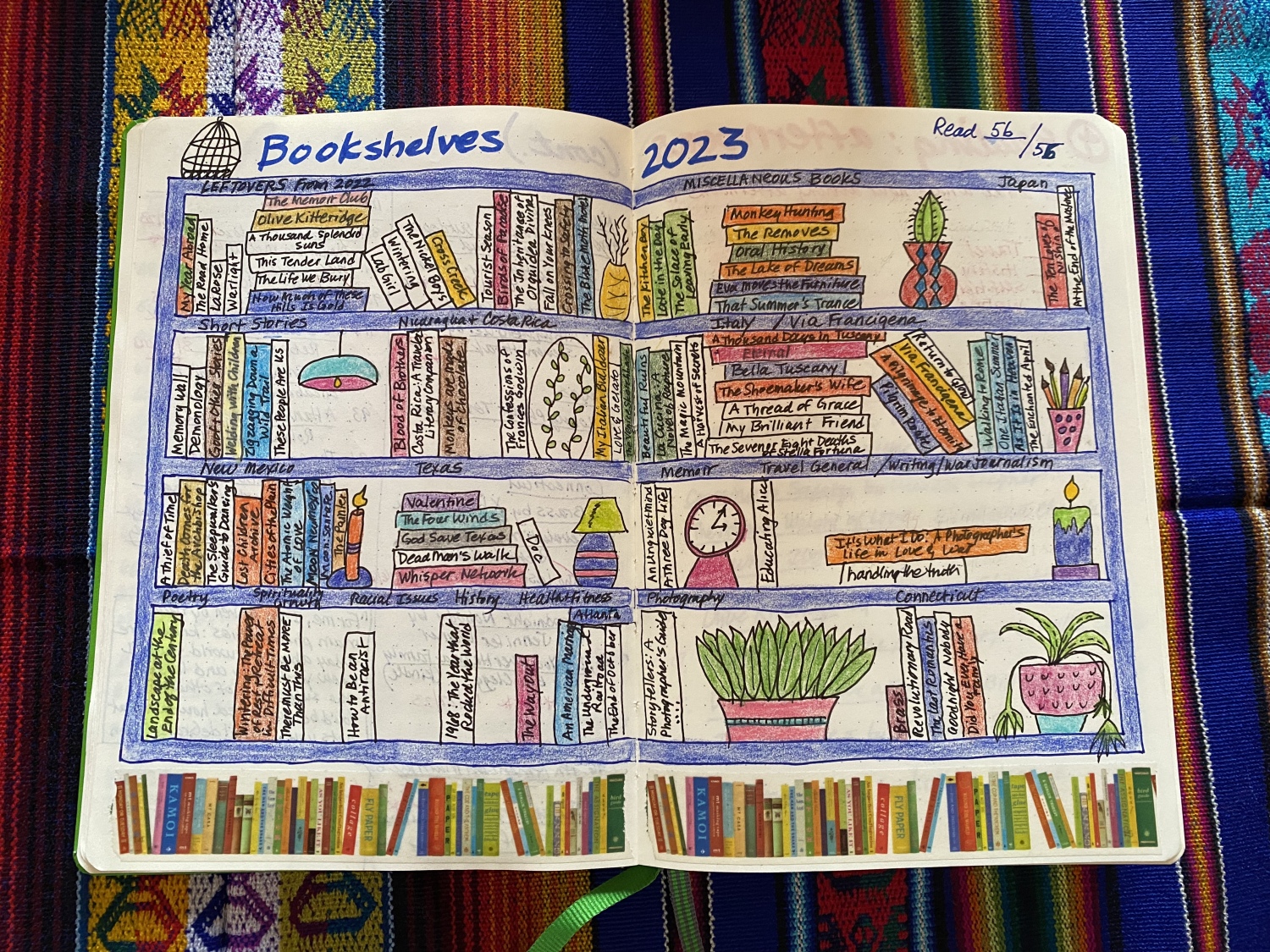
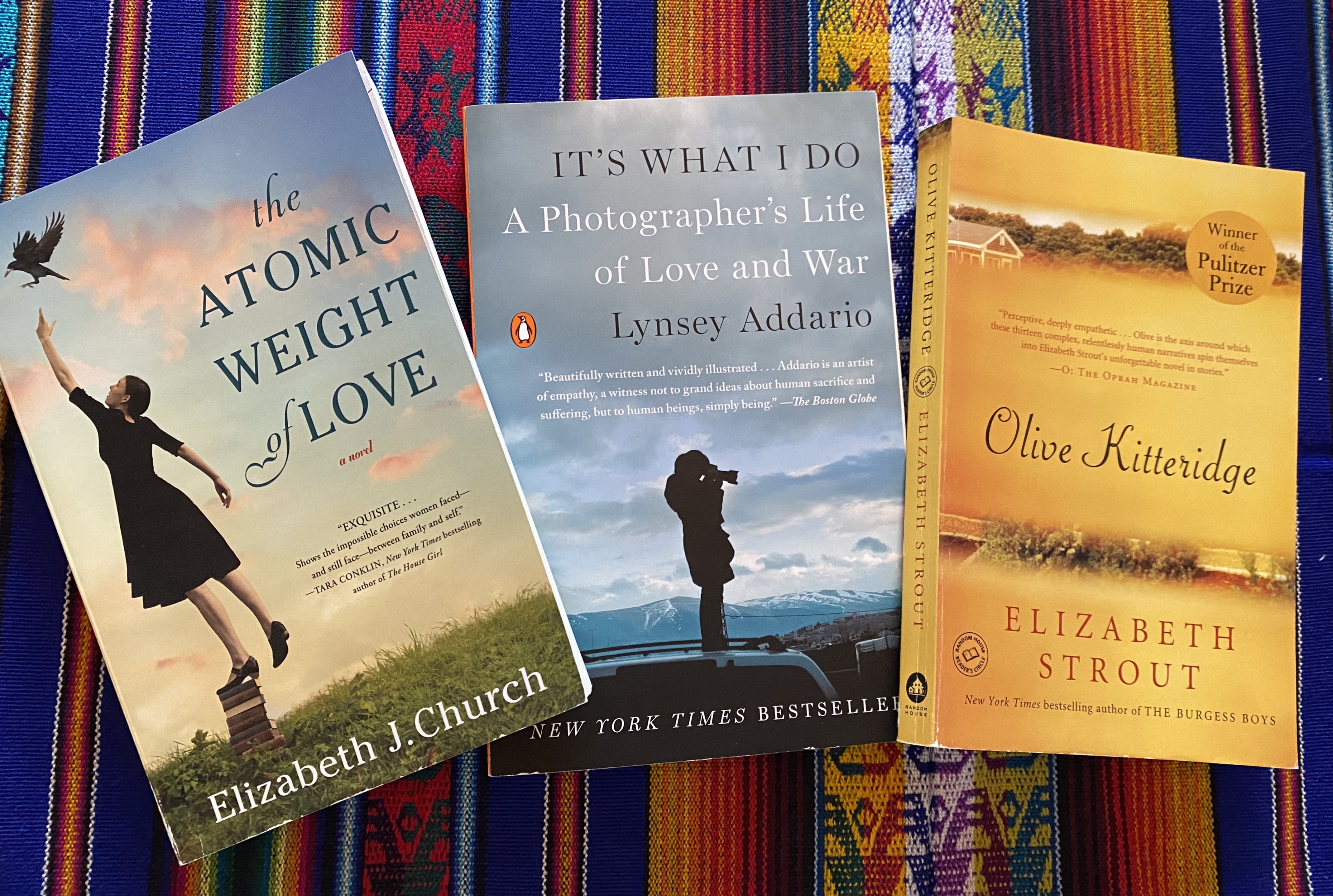
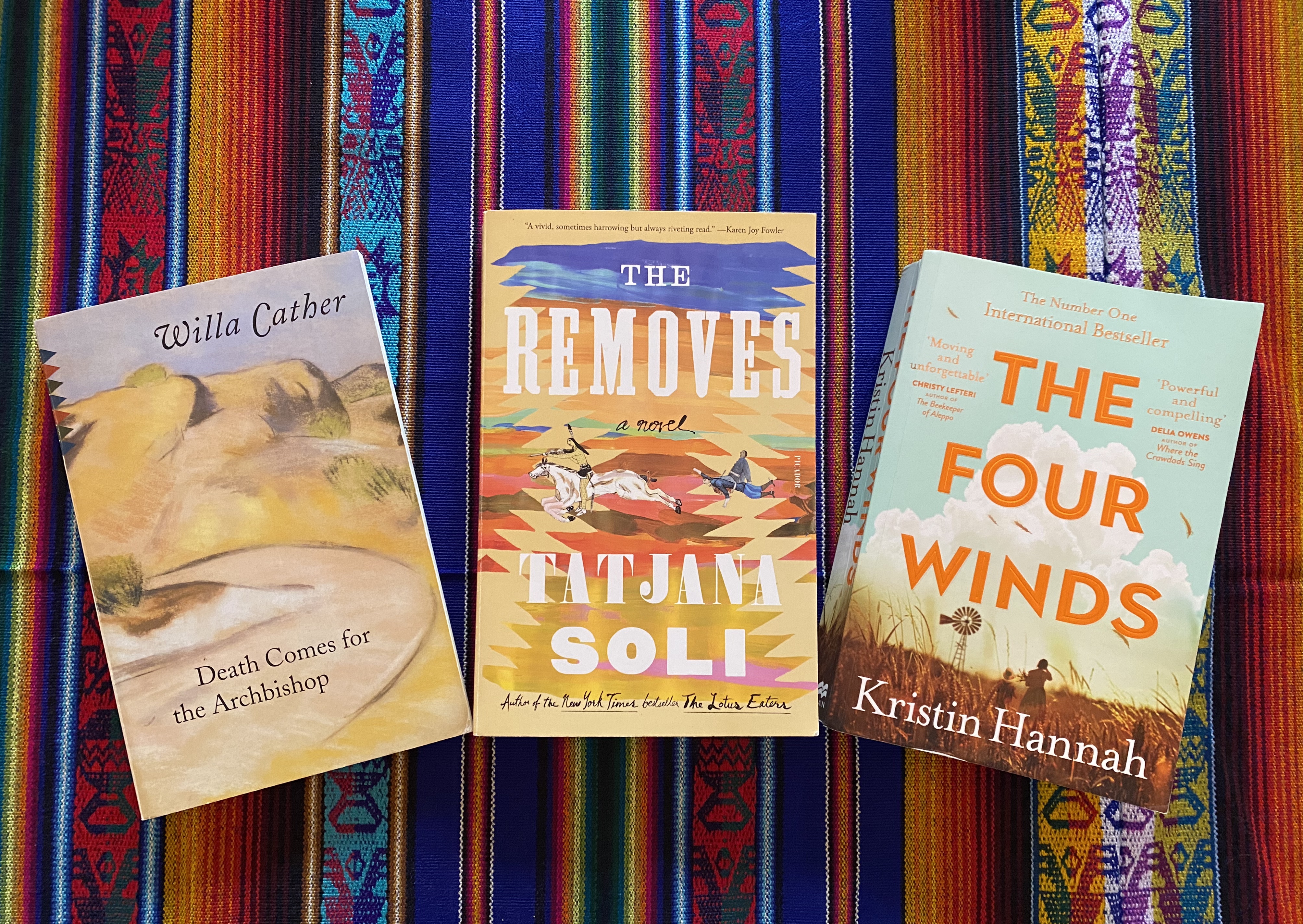
Here are some of my previous recaps:


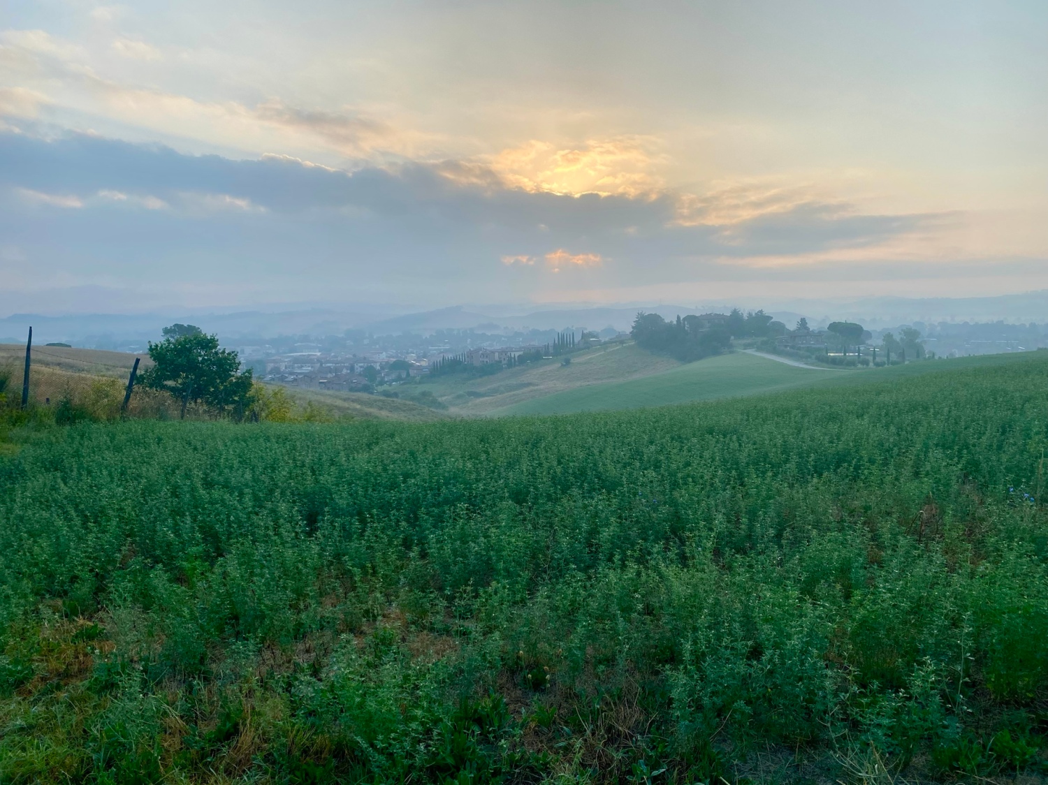


 and cappuccino. We were so happy because we were only 35 minutes from Albergo Bernini, where we would stay for 2 nights.


 I was able to see both her skull and thumb on display.


 stuffed with spinach and ricotta, topped with olive oil and cherry tomatoes. The waiter was super friendly and made a production of shaking out Darina’s napkin and placing it with a flourish on her lap; Darina was surprised by the theatrics as it is not a Slovakian custom to put a napkin on one’s lap. Darina enjoyed a mushroom and truffle risotto – with her napkin on her lap!


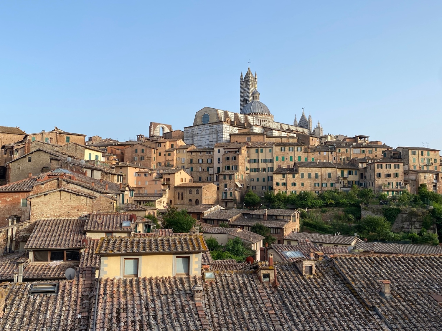
 sauce. She had been seeing stuffed wild boar heads in souvenir shops all over Siena and felt the boar was calling her name. It was very pleasant sitting at these strange tables on the super sloped street with views of the Duomo before us.


You must be logged in to post a comment.