We got a slow start this morning, stopping in Fort Collins at the Little Bird Bakeshop for a quiche (for me). Mike had eaten waffles and Alex had eaten leftovers at our Solarium Airbnb.
We drove to Lory State Park, hidden in the foothills twenty minutes west of Fort Collins. Its 2,591 acre landscape includes unique rock outcroppings, sandstone hogbacks, grassy open meadows, shrubby hillsides and ponderosa pine forests. Formerly ranchland, Lory State Park was purchased from the original owners in 1967. It was named after and dedicated to Dr. Charles A. Lory (1872-1969), president of Colorado State University from 1909 to 1940.
At the park, we hiked the Arthur’s Rock Trail. Arthur’s Rock, a jutting granite formation named for an early settler, overlooks the Fort Collins area from an elevation of 6,780 feet. We only hiked to the first scenic overlook. It was supposed to be 1.7 miles each way, but we stopped with 0.6 miles still to the summit. Mike was having his AFib (Atrial fibrillation — an irregular heartbeat, or arrhythmia, that can lead to blood clots, stroke, heart failure and other heart-related complications) and was worried about pushing it too much. Besides, we were all getting hungry for lunch.
We were graced with a delicate breeze and blue skies. Grasses danced, birds chirped, and we enjoyed fabulous views over the north side of Horsetooth Reservoir. We wound through forested mountainsides and open meadows. We traveled through different ecosystems in the 1,000 foot elevation change.
Arthur’s Rock Trail
Arthur’s Rock Trail
Arthur’s Rock Trail
Arthur’s Rock Trail
Arthur’s Rock Trail
Arthur’s Rock Trail
Arthur’s Rock Trail
Arthur’s Rock Trail
Arthur’s Rock Trail
Arthur’s Rock Trail
Arthur’s Rock Trail
Arthur’s Rock Trail
Arthur’s Rock Trail
Arthur’s Rock Trail
Alex and Mike at Arthur’s Rock Trail
Alex and me at Arthur’s Rock Trail
Arthur’s Rock Trail
Ponderosa pine
Arthur’s Rock Trail
Arthur’s Rock Trail
Arthur’s Rock Trail
Arthur’s Rock Trail
Arthur’s Rock Trail
Arthur’s Rock Trail
Arthur’s Rock Trail
Arthur’s Rock Trail
Arthur’s Rock Trail
me with Mike at Arthur’s Rock Trail
Arthur’s Rock Trail
Arthur’s Rock Trail
Arthur’s Rock Trail
Arthur’s Rock Trail
After our hike, we ate lunch at Lucille’s Creole Cafe in Fort Collins. We ordered the powdered sugar beignets (ben-yay), the state doughnut of Louisiana. Beignets were brought to Louisiana in the 1800s by the French Acadians from Nova Scotia. The traditional New Orleans beignet is a square piece of dough deep fried until puffy, served hot and covered in powdered sugar.
Lucille’s Creole Cafe
We enjoyed quite a feast. I had a popcorn shrimp salad with avocado and cornbread.
popcorn shrimp salad with avocado and cornbread
Mike had Gumbo: “A grand New Orleans stew. Homemade from ingredients selected daily (okra, chicken) and served with rice and cornbread.” Alex had red beans and rice: “Famous Southern ‘Wash Day’ lunch served with homemade andouille sausage.”
After our hike, we went to New Belgium Brewing. It is supposedly one of the best places to work in the country.
New Belgium Brewing
We saw employees drinking beer, a man wearing a wedding dress, a tattooed bartender wearing skin-tight shorts and a wild colorful shirt. There was supposedly a “self-guided tour” but someone was actually explaining things about the brewing process, so we begged off.
New Belgium Brewing
New Belgium Brewing
New Belgium Brewing
New Belgium Brewing
New Belgium Brewing
Mike and Alex ordered a flight of beer and I just sipped. I was way too stuffed after our lunch at Lucille’s.
Mike and Alex with their flight
Alex and me 🙂
the flight
fading ad in Fort Collins
Leaving Fort Collins, we drove in heavy traffic south to Denver. We checked in at Hyatt House Denver and Alex and Mike went to Whole Foods nearby for dinner. I ate my leftover popcorn shrimp salad. We got drinks from the Hyatt House Bar – me a Cabernet Sauvignon and Alex a “neat” whiskey. We sat in the hotel room, which was large and comfortable, and the guys watched football while I put up pictures on Instagram and Polarsteps.
After leaving Cheyenne, Wyoming we drove directly to “Colorful Colorado.” We passed metal sculptures of bison on a hilltop and had a view of the Rockies. We stopped briefly at the Visitor Center in Fort Collins and then took the scenic route to the Alpine Visitor Center at Rocky Mountain National Park.
Sculpture at the Fort Collins Visitor Center
We passed the Horsetooth Reservoir near the town of Stout, population 47 1/2. At Horsetooth Mountain Park, we picked up trail maps for a hike we planned to do the following day.
Horsetooth Reservoir
Horsetooth Reservoir
We drove past the “Masonville Mercantile: A Want & Wish Store” and the Bobcat Ridge Natural Area, passing a sign that said DR. BOB’S SNAKE OIL CURES ALL.
Masonville Mercantile: A Want & Wish Store
Snake Oil Cures All
On 34W, we were welcomed to… Sylvan Dale Ranch (guest ranch, weddings, horsebackriding), but we continued on.
The Big Pipe was a canyon of rocky cliffs dotted with pine trees. We took a road along the Big Thompson River. The Big Pipe carries water to Horsetooth Reservoir. This is the entrance to the Rocky Mountains by way of the Big Thompson River Canyon.
We passed the Colorado Cherry Company, the Snowy Silver Lodge and Drake. A sign warned of Open Range Livestock on Road. By 11:20, it was 65°F, and yellow cottonwoods gilded the forests. On the north-facing side, the pine trees squatted in dark dense clusters.
There was the Glen Haven General Store, an alpine meadow, and the Lumpy Ridge Trailhead. MacGregor Ranch (1873) boasted of “Grass-Fed Beef.” We sailed past the Black Canyon Inn and before we knew it, we were in Estes Park, gateway town to Rocky Mountain National Park. We saw Dick’s Rock Museum, Coffee on the Rocks, Lazy R Cottages, Sticks & Stones Home Furnishings, and Bird & Jim Colorado Cuisine.
Our route today. Map from a pamphlet distributed by the Fort Collins Convention & Visitors Bureau and the Colorado Welcome Center: “Experience the Scenic Gateway to the Rockies.”
The Rocky Mountains form one of the world’s longest ranges, stretching almost unbroken from Alaska to below the nation’s southern border. Since 2009, Congress protected most of Rocky Mountain National Park as wilderness under the 1964 Wilderness Act. The designation protects forever the land’s wild character, natural conditions, opportunities for solitude, and scientific, educational and historical values.
Thrust up by earth’s forces 40-70 million years ago, then sculpted by multiple glacial episodes, the Rockies are “new” in geologic terms.
We entered the park through the montane ecosystem (below 9,000 feet). On warmer south-facing slopes, Ponderosa pines grow. Trees here are tall, up to 150 feet, and along with chokecherry, currant and juniper bushes, nourish many animals, insects and birds: beavers, otters, and elk. On cooler north-facing slopes, forests are dense with Douglas fir and lodgepole pine.
We drove up the Trail Ridge Road, past Beaver Ponds, where we got out to walk a short trail. Beaver dams once blocked the stream flows here, creating a pond. Silt and rich organic debris carried down from Hidden Valley accumulated behind the dam. In time, the dams decayed, draining the ponds and leaving fertile soil over 20 feet deep.
Sedges and grasses grow in this newly established soil to form marshes. Lush meadows developed over time as tree seedlings invaded the open space creating a new subalpine forest of pine, spruce and fir trees.
Beaver Ponds
Beaver Ponds
Beaver Ponds
Beaver Ponds
At the Hidden Valley picnic area, we had a picnic lunch.
Then we stopped at Rainbow Curve Overlook to admire the landscape. Rainbow Curve is in the Subalpine part of the park (9,000-11,400 feet).
Snow that falls in the alpine zone blows down to the subalpine, creating a wet ecosystem with over 30 inches of precipitation annually. Engelmann spruce and flat-needled fir trees prevail, reaching 100 feet. The understory supports shrubs like blueberry, wax currant, huckleberry, and Wood’s rose. Wildflowers like arnica, fairy slipper, twinflower, and purple elephant’s head are abundant in open meadows.
Rainbow Curve
Rainbow Curve
Rainbow Curve
Rainbow Curve
Mike at Rainbow Curve
Rainbow Curve
We continued the drive up Trail Ridge Road. Forest Canyon lay to the south. Tall snow poles were in place along the road to show the way during big snowfalls. The Big Thompson River flows swiftly down Forest Canyon as it has for thousands of years. Several times during the past two million years, frigid climates caused glaciers to form and move down the canyon. Flowing ever so slowly, these deep “rivers of ice” carved out Forest Canyon along an ancient fault line.
We stopped at the Forest Canyon Overlook. At the higher elevation, the temperature had dropped to 56°F.
The subalpine forest ecosystem of Forest Canyon is abundant with life. Difficult to access through fallen trees and steep terrain, Forest Canyon furnishes protected habitat for hundreds of plants and animal species – from elk herds to microorganisms.
A short trail here crossed the tundra – a Russian word for “land of no trees.” Here above the treeline, winds often exceed 100 mph (160 km per hour) and temperatures remain below freezing for at least five months each year.
Forest Canyon Overlook
Forest Canyon Overlook
We stopped at the Lava Cliffs Overlook.
Lava Cliffs
Lava Cliffs
Lava Cliffs
We crossed the highest point on the road at 12,183 feet (3,713 meters).
We finally reached the Alpine Visitor Center. Alpine Tundra (above 11,400 feet) is a fragile world, characterized by extremely thin soil, drying winds, and bitter cold. Many plants hug the ground in dense mats (avens), preserve moisture with waxen leaf surfaces, or trap warmth against stems and leaves with hairs. Animals must adapt or die.
There in the crowded parking lot, I had an altercation with a guy. The wind was blowing like there was no tomorrow and when I opened my car door, he yelled “Hold on to your door so it doesn’t hit my car!” (I was already holding it, and the door didn’t hit his car). I said, “Rudeness personified. That guy is an asshole,” (talking to Mike but saying it loud enough for him to hear). He said, “Some guy messed up my car with his door.” I replied, “Well, don’t take it out on me!”
I can’t stand bullies.
We walked up along the Alpine Ridge Trail in the midst of a fierce and relentless bitter wind. This trail is affectionately known as “Huffers Hill,” because it takes your breath away. We walked through a delicate yet hardy environment.
The scattered rocks form “patterned ground” that is found only in Arctic and Alpine regions where temperatures remain below freezing at least five months each year. During the last Ice Age, freezing and thawing of this tundra topsoil forced these patterns to the surface.
Some patterned ground has indistinct forms, while others are precise circles or other forms. The degree of slope determines the rock patterns. Rock streams “flow” downhill on Sundance Mountain in the distance, while polygons and circles form on level surfaces.
Alpine Visitor Center
Alpine Visitor Center
Alpine Visitor Center
Alpine Visitor Center
Alpine Visitor Center
Alpine Visitor Center
Alpine Visitor Center
Alpine Visitor Center
Alpine Visitor Center
Alpine Visitor Center
Alpine Visitor Center
Mike at the Alpine Visitor Center
Alpine Visitor Center
Alpine Visitor Center
Leaving the Alpine Visitor Center, we retraced our drive up and stopped at the Gore Range Overlook. We could have gone further west and south on Trail Ridge Road, but we needed to return to Fort Collins to meet our son.
The Gore Range was named for Sir St. George Gore, an Irish aristocrat who was led there on a hunting expedition in 1854 by mountain man Jim Bridger. In 1976, Congress set aside 133,000 acres of the Gore Range as Eagles Nest Wilderness Area, which remains nearly as wild today as when Gore and Bridger first entered it.
Gore Range
Gore Range
Gore Range
Gore Range
Gore Range
Gore Range
Gore Range
Gore Range
Gore Range
We stopped again at Forest Canyon Overlook. This time, we walked to the other side of the road.
Forest Canyon Overlook
Forest Canyon Overlook
Forest Canyon Overlook
Forest Canyon Overlook
Forest Canyon Overlook
Forest Canyon Overlook
Forest Canyon Overlook
We made our way slowly to lower elevations, back to the montane ecosystem. The yellow trees on the mountains were glowing in the afternoon sunlight.
Colorful trees at Rocky Mountain National Park
Colorful trees at Rocky Mountain National Park
Colorful trees at Rocky Mountain National Park
Colorful trees at Rocky Mountain National Park
Colorful trees at Rocky Mountain National Park
Colorful trees at Rocky Mountain National Park
Colorful trees at Rocky Mountain National Park
Colorful trees at Rocky Mountain National Park
On the way back, we forked off at the Deer Ridge Junction and stopped briefly at Sheep Lakes.
Sheep Lakes
Sheep Lakes
Sheep Lakes
This time, we stopped at the Fall River Visitor Center. Here are my cancellation stamps for Rocky Mountain National Park.
(Information about Rocky Mountain National Park is from National Park Service pamphlets and signs.)
cancellation stamp for Rocky Mountain National Park
On our way to Fort Collins, where we would meet our son Alex and spend the night, we passed God’s Country Cowboy Church. Someone had a bumper sticker that said, “I brake for wildflowers.” I liked that.
In Fort Collins, we stayed in a strange little place called Solarium. As the guy gave us a tour of the place, he showed us the tent and outdoor area where we were allowed to smoke cannabis, but this privilege was wasted on us, as we don’t do that stuff.
Solarium
Solarium
Solarium
Solarium
Solarium
Solarium
When Alex arrived in Fort Collins, we went into the town to have dinner at Restaurant 415.
murals in Fort Collins, CO
murals in Fort Collins, CO
murals in Fort Collins, CO
murals in Fort Collins, CO
murals in Fort Collins, CO
square in Fort Collins
murals in Fort Collins, CO
We spent the night in Solarium; the next day, we’d head to Denver after hiking the Arthur’s Rock Trail at Lory State Park.
After eating leftovers for lunch in our room at The Plains Hotel, we went on a self-guided Historic Cheyenne Walk.
The Paramount Cafe was originally the Capitol Avenue Theatre built in 1904. It has housed a hotel, two theaters, a millinery (a ladies hat store), and survived two fires. It is now a cocktail lounge.
Paramount Cafe
Paramount Cafe
The Nagle-Warren Mansion has a long history that involves two men, Erasmus Nagle and Francis E. Warren. Erasmus Nagle was known as the “Merchant King of Wyoming;” he sold pots and pans to rural folks and became wealthy enough to afford to build a brick house in 1874. He claimed he had the “biggest and best house in Cheyenne” so was shaken when Francis E. Warren built a sizable house next door. Erasmus decided to build a bigger house at the far east end of the block, using inferior stones that were deemed unfit in the building of the new Capitol Building. After he died, the inferior stones were crumbling and the home was covered in concrete stucco. At that time Senator Warren bought the house, now known as the Nagle-Warren Mansion. It is now a bed and breakfast, listed in the Smithsonian Guide to Historic America and the National Register of Historic Places. Inside we could see the home’s cherry, maple and oak woodwork, original chandeliers and 19th century furniture. Warren’s good friend President Theodore Roosevelt and other famous people spent time here.
Francis E. Warren was one of the most influential men in Wyoming. His sharp business savvy and easy ways made him the richest man in the territory by the early 1880s. In 1890, when Wyoming became a state, he was elected as one of the first two senators and held the office for 37 years.
Nagle-Warren Mansion
Nagle-Warren Mansion
interior Nagle-Warren Mansion
interior Nagle-Warren Mansion
interior Nagle-Warren Mansion
interior Nagle-Warren Mansion
First United Methodist Church (also known as First Methodist Church) at 18th and Central was built with local red sandstone in 1890 and added to the National Register of Historic Places in 1975. The meager congregation of nine, founded in 1867, paid the railroad a dollar for two lots to build their sanctuary. In 1871, the first church was dedicated and nicknamed the “Little White House.”
To make room for the new structure in 1890, the Little White House was dragged into the middle of Central Avenue using horses and ropes. For three years, weddings, funerals and services were held in the little church in the middle of the street. The current building was dedicated in 1894. The Little White House was then dragged to the Union Pacific rail yard where, in its final days, it was used as a hay barn.
First United Methodist Church
The Ithamar C. Whipple Mansion was built by Whipple in 1883. He, Nagle, and banker Henry Hay developed the Union Mercantile into a wealthy enterprise. Whipple was also a sharp financier and cattleman.
Territorial Supreme Court Justice John Lacey also owned this house at one point. He was legal counsel for Thomas Horn, Jr. during his murder trial. For a number of years in the 1930s, it was a Greek gambling house and brothel. Also among its residents were hoards of pigeons that made themselves comfortable in the cupola to such an extreme that the tower had to be removed.
Tom Horn was an American scout, cowboy, soldier, range detective, and Pinkerton agent in the 19th-century and early 20th-century West. Horn was convicted in 1902 of the murder of 14-year-old Willie Nickell, the son of sheep rancher Kels Nickell, who had been involved in a range feud with neighbor and cattle rancher Jim Miller. On the day before his 43rd birthday, Horn was executed by hanging in Cheyenne.
Ithamar C. Whipple Mansion
Ithamar C. Whipple Mansion
We wandered a bit more through the neighborhood and found other historic homes converted into businesses or abandoned.
Cheyenne houses
Cheyenne houses
Cheyenne houses
(Information on the Historic Walk is from the Downtown Cheyenne Historic Walking Tour pamphlet created by the Cheyenne Downtown Development Foundation.)
We found more of the cool painted “talking” boots throughout the town.
“Outlaws of Wyoming” boots by Cheyenne Artists Guild
“Outlaws of Wyoming” boots by Cheyenne Artists Guild
“Gamblers Boot” by Max Larkin
“Gamblers Boot” by Max Larkin
“Gamblers Boot” by Max Larkin
“Journey of the Soul” boot by Vicki McSchooler
“Licensed to Boot” by Carey Junior High Art Club
“Licensed to Boot” by Carey Junior High Art Club
“8 Second Steps to the Big Time” by Ross Lampshire
We drove to Holliday Park to see Cheyenne’s Big Boy 4004. Twenty-five Big Boys, the world’s largest steam engines, were built exclusively for Union Pacific by the American Locomotive Company in Schenectady, New York between 1941 and 1944. Each locomotive was 132 feet long and weighed 1.2 million pounds.
On October 31, 1958, Cheyenne’s 4004 took its final run, traveling from Cheyenne to Laramie. It was stored for a few years in Laramie before being donated to the City of Cheyenne. Cheyenne’s 4004 is one of eight remaining Big Boys on display throughout the country.
The museum showcases one of the largest Western carriage collections in the U.S. Many different carriage services operated in the early days of the Union Pacific Railroad to support the multitudes arriving by rail.
western carriage
western carriage
Western Passenger Wagon
western carriage
western carriage
western carriage
western carriage
western carriage
western carriage
me in a Canopy Top Surrey
Lil Lous Popcorn & Peanut Wagon
western carriage
western carriage
U.S. Mail Wyoming
Hose Wagon
western carriage
Escort Wagon
Lakeview Ice Company Ice Wagon
Prairie Schooner
western carriage
Hansom Cab
Plains Dairy
Wooden Water Wagon
W.E. Dinneen Garage and Filling Station Oil Wagon
Top Buggy
Ambulance St. Johns Hospital
Laramie County Library
Spring Wagon
Yellowstone Coach
Three-Seated Canopy Top Surrey
western carriage
Laycock Horse Trailer
Cheyenne Fire engine
The museum also features a new narrative on the Cheyenne Frontier Days experience, which has been going on since 1897 with the world’s largest outdoor rodeo and Western Celebration. It was held from July 19-28, 2019.
Theodore Roosevelt looked out over the events of Cheyenne Frontier Days in 1910. The President’s arrival in Cheyenne was so significant that many special events were scheduled. Even the Barnum and Bailey Circus was added to the roster that year.
Theodore Roosevelt at Cheyenne Frontier Days in 1910
We found that in the Wild Horse Race, a rider has 90 seconds to train and ride a wild horse.
Originally built to feed cowboys out on the range, chuckwagons, or “chucks,” were made to move quick and cook up a tasty meal. The Chuckwagon Race, a fast-paced race of chucks fueled by horsepower, was discontinued in 1994 because of liability issues.
Saddle Bronc is one of the oldest and most difficult rodeo events. In order to score, the cowboy must synchronize himself to the motion of the horse. The cowboy holds on to the horse using a rope attached to a halter, his legs, and only one hand. His feet must stay at the top of the horse’s shoulder for two jumps at the start of the ride, called “marking out,” and continue to spur the shoulders throughout the ride. The cowboy’s free hand cannot touch his body or the horse for a full 8 seconds.
Bull riders must ride the bull for 8 seconds. The bull will try to unseat the rider off by spinning, kicking, bucking and twisting. If the cowboy stays on, he scores.
Steer roping has cowboys competing to rope steers the fastest. In competition, the cowboy ropes the steer around the horns, which are reinforced for protection. After the rider ropes the steer, he ties off rope to saddle and as quick as he can ties three legs together to finish.
Barrel racing is when cowgirl and horse engage a cloverleaf pattern around barrels as far apart as 105 feet. The course is often run in under 20 seconds.
Steer wrestling requires the steer wrestler, or bulldogger, to lean off his horse and onto a sprinting steer. From there the cowboy must catch the steer (often weighing between 450-650 pounds) behind the horns, stop its momentum (it can often run 30 mph), and wrestle it to the ground with all four feet pointing the same direction.
We saw movie posters, Native clothing, a Rodeo Clown uniform, posters for Cheyenne Frontier Days, western paintings, and cowboy and horse sculptures.
Native American clothing
“Two Fisted Law” movie poster
Poster for 73rd Cheyenne Frontier Days
Fall Round Up poster
cowboy sculpture
horse sculpture
Rodeo Clown Uniform
Western painting
In the Eighth Month of Winter by Gary Carter
Flying Hoofs by Lloyd Hartling
Ain’t No Easy Way by Rob Abbet
Information about the events at Cheyenne Frontier Days is from signs at the museum.
After leaving the Frontier Days Museum, we went into the adorable shop Mid Mod Etc. on Pioneer Avenue. It specialized in 50s/60s furniture, accessories, and automobilia. Sadly, it would be closing by year-end because the owner planned to retire.
Mid Mod Etc
Mid Mod Etc
Mid Mod Etc
Mid Mod Etc
Mid Mod Etc
Mid Mod Etc
Mid Mod Etc
Mid Mod Etc
Mid Mod Etc
Mid Mod Etc
Mid Mod Etc
Mid Mod Etc
Mid Mod Etc
Mid Mod Etc
We had dinner at the Met Downtown. I had a “Contortionist and Cucumber Collins” – gin, muddled cucumber, lime, a club soda, and orange flower water. I also had the soup du jour: a very thick chicken tortilla soup with a cream base and a Metropolitan Salad: arugula, peaches, goat cheese, candied walnuts and citrus vinaigrette. Mike had a Cowboy State Golden Ale and I’m sure he ate some food, but I don’t remember what.
Metropolitan Downtown
me at Met Downtown
Metropolitan Salad
After dinner, we went back to the Wrangler store, where we both did some damage suiting ourselves up with plaid flannel shirts. 🙂
Our first morning in Cheyenne, we slept in until 7:00. I remember the days when “sleeping in” was closer to 10:00 or later! Breakfast in the classy dining room at the Plains Hotel consisted of eggs, bacon and French toast.
We overheard that someone who goes by the name of Astrid bought the Plains Hotel at auction in 2015.
We walked to the Cheyenne Depot to start our day, passing the boots “made for talking” and the bright red Wrangler store.
“Don’t Feed the Animals” boot by Jill Pope
“Don’t Feed the Animals” boot by Jill Pope
me with “Downtown Cheyenne” boot by various artists
The Wrangler
Cheyenne Street Trolley
“The Iron Horse” by Lyle Nichols
“Governors of Wyoming” boot by Alice Reed
“Governors of Wyoming” boot by Alice Reed
“A New Beginning” by Veryl Goodnight, Sculptor
“Milestones: Chamber 100th Anniversary” boot by Jill Pope
We spent some time in the Cheyenne Depot Museum. Formerly the Union Pacific Depot, it has been restored to its original glory. The museum is rich with railroad history and exhibits.
The Union Pacific Depot replaced a small 1867 wooden structure that sat on the same spot. Due to the influence of the cattle barons, the railroad built one of the finest depots in America, finished in 1888. Of Richardsonian Romanesque styling, it used polychromatic stones – two colors of sandstone from the same quarry, a rarity.
In 1889, it was decided that the central repair shops for the entire Union Pacific system would be located in Cheyenne. Over 3,000 people would live and work for the railroad in the town.
The Seth Thomas clock in the tower was added in 1890; it still only loses about a minute a month. The lobby was redesigned in 1929 in Art Deco style. Completely restored in 2004, the depot is now a National Historic Landmark.
The Cheyenne Depot
The Union Pacific Railroad would be a prominent player in Wyoming’s Statehood, soon to follow (July 10, 1890), and the future of Cheyenne.
In 1862, the Pacific Railroad Act was approved by Congress and signed into law by then-President Abraham Lincoln, an enthusiastic supporter of railroads. Congress had finally decided on a route following the Platte River Valley and two railroad companies were chartered. The Union Pacific (UP) would lay track westward from Omaha, while the Central Pacific (CP) would lay track eastward from Sacramento and they would meet someplace in between. Nearly 1800 miles separated these two points. A contest quickly developed to see which company could lay the most track the fastest.
Workers did not lay the first rail in Omaha until 1865 due to a shortage of money, materials and men due to the U.S. Civil War. In 1867 a base or “division point” for the railroad was selected, and it was called “Cheyenne” in honor of a fierce Indian tribe of the area. This location was chosen because it was where the gradual slope of the prairie met the steepening grades of the Laramie Mountains (previously known as the Black Hills).
laying the tracks
railroad coming through
Private property
During the winter of 1867-68, the Union Pacific Railroad ended at Cheyenne. Barracks were built for the workers, who set about working on the railroad facilities in Cheyenne and working their way up the daunting grade toward Sherman Pass. With the addition of the railroad workers, the town’s population boomed. Many estimates put the population of the town during this time at 7,000-10,000 people. Even with the building boom, space was at a premium. The image below shows what 16th Street in Cheyenne looked like a couple of months after the railroad had arrived.
Cheyenne after the arrival of the railroad
The two railroads met at Promontory Point, Utah on May 10, 1869. A ceremonial golden spike celebrated the completion of the first transcontinental railroad that crossed America.
It was intended that Cheyenne should be one of the most important railroad cities in North America. It has often been said that if not for the Union Pacific Railroad, the City of Cheyenne would not exist.
Train model in the museum
ticket window
Union Pacific Railroad Platte Valley Route Grand Opening: May 10, 1869
Cheyenne has had a close connection with the Union Pacific’s passenger service from the time the first passenger train arrived in 1867 until Amtrak moved out of the city in 1979. A passenger’s experience varied by what he could afford. First class passengers received the best cars, the best meals, and the best accommodations at the Union Pacific’s depots. Migrants or people without money were often treated little better than human freight with uncomfortable cars and equally uncomfortable accommodations trackside.
Emigrants who were not able to pay higher fares for first class accommodations found themselves in the emigrant cars. These cars got minimal attention from the railroad. They were hot in summer and freezing in winter and generally unpleasant. Passengers on these cars made the best of things by bringing their own food, blankets and anything else that might make their trip more comfortable.
a view of downtown Cheyenne, circa 1920
Illustration of an emigrant train published in Harper’s Weekly, November 13, 1886
dining car menu
Pullman parlor car, circa 1885
suitcase packed for travel
suitcase packed for travel
A Union Pacific Railroad travel magazine
Between November 1948 and March 1949, a series of blizzards struck the West. Nebraska, Colorado, Kansas, and Wyoming bore the brunt of these storms as winds often reached 80 mph (128 kph) forcing the temperatures down to -51°F. Over 100 citizens perished and livestock losses topped half a million head. With drifts approaching 50 ft., citizens from nine states were completely isolated.
For the railroads, the storms were devastating. The Union Pacific’s lines were at the epicenter of the blizzards. The railroad would call in over 14,000 men, 180 bulldozers, 48 snowplows, and every rotary that could be found and moved to fight the storms. Despite their efforts, 44 trains were frozen to their rails and hundreds of travelers were stranded.
The Blizzard of ’49
The Burlington track, now referred to as the BNSF Railroad, continues to run north and south through Denver into Texas and north to the Wyoming coal fields and connections into central Wyoming and on into the northwest through Montana. Today, a sophisticated dispatch system is used to control the trains.
desk from the old train depot
control panel for today’s railroad
The upstairs of the museum had a huge model train setup that was captivating.
model train at the Cheyenne Depot Museum
model train at the Cheyenne Depot Museum
model train at the Cheyenne Depot Museum
model train at the Cheyenne Depot Museum
model train at the Cheyenne Depot Museum
model train at the Cheyenne Depot Museum
model train at the Cheyenne Depot Museum
model train at the Cheyenne Depot Museum
model train at the Cheyenne Depot Museum
model train at the Cheyenne Depot Museum
model train at the Cheyenne Depot Museum
model train at the Cheyenne Depot Museum
model train at the Cheyenne Depot Museum
model train at the Cheyenne Depot Museum
model train at the Cheyenne Depot Museum
model train at the Cheyenne Depot Museum
model train at the Cheyenne Depot Museum
model train at the Cheyenne Depot Museum
model train at the Cheyenne Depot Museum
model train at the Cheyenne Depot Museum
model train at the Cheyenne Depot Museum
Leaving the Depot, we strolled around the town on the way to our next destination. We encountered more of the “boots made for talking,” some buildings with fading ads, and street murals.
“Memories of the Old West” boot by Cody Hamil
“Memories of the Old West” boot by Cody Hamil
downtown Cheyenne
downtown Cheyenne
downtown Cheyenne
downtown Cheyenne
downtown Cheyenne
downtown Cheyenne
downtown Cheyenne
downtown Cheyenne
downtown Cheyenne
We found a great mural about the suffragette movement in Wyoming. The passage of Wyoming’s Suffrage Law in December 1869 was over 50 years before the enactment of the 19th amendment to the United States Constitution that was passed on August 26, 1920 giving all women in America the right to vote.
Apparently, one of the main reasons for the passage of Wyoming’s suffrage law was intended as a public relations gesture to attract more settlers into the Wyoming Territory. Although the new law also gave women the right to hold public office, most of the men assumed that the women would have no interest in territorial politics and would choose to stay home. Instead, the newly enfranchised female voters promptly demanded a more active role for women in territorial government. This so upset the all-male legislature, that in 1871 they tried to repeal the 1869 suffrage bill. It failed to pass legislation by only a single vote.
When Wyoming entered the Union in July of 1890, it was the only state to have given women the right to vote. Colorado became the second state to pass a suffrage bill in 1893, and they were followed by Utah and Idaho in 1896.
suffragette movement in Wyoming
suffragette movement in Wyoming
suffragette movement in Wyoming
We arrived at the Cowgirls of the West Museum close to 11:00. We watched a short film about a famous female rodeo rider. There were displays of cowgirl clothes and framed stories about famous women cowgirls.
Cowgirls of the West Museum
Cowgirls of the West Museum, founded in 1995 by a group of trailblazing women, is dedicated to telling the remarkable stories of pioneering women who worked hard, right alongside men, to create the American West.
Women preparing for a move to western ranches and farms were advised to take no fine clothing, only “things suitable for everyday wear,” such as “calico frock dresses, plainly made, with no hoops, and sun bonnets.”
Back in the days when the sidesaddle ruled the female equestrian world, if a woman appeared in trousers because she was riding her horse in the astride style, she could be arrested and jailed for indecent exposure.
When it became socially acceptable that women could ride astride and wear split skirts, the Shipley Saddle Company of Kansas City, Missouri, found new customers. Early women’s astride saddles were compact and nearly 10-12 pounds lighter than the standard’s men’s stock saddle.
Styles for a Rigorous Life
cowgirl fashion
cowgirl fashion
cowgirl fashion
Women’s Astride Saddles and Split Skirts
Chaps
cowgirl fashion
cowgirl fashion
cowgirl fashion
The museum tells stories about Willa Cather, Pulitzer Prize-winning author of over 15 books; Laura Ingalls Wilder, whose prairie life was portrayed in the popular TV series Little House on the Prairie. Evelyn Cameron, Montana’s frontier photographer; Mardy Murie, Wyoming’s Grandmother of Nature and Conservation; Prairie Rose Henderson, Champion Bronc Rider; Mabel Strickland, “The Cowgirl’s Cowgirl;” Dale Evans, who co-starred with Roy Rogers in The Cowboy and the Señorita; the “unsinkable” Margaret Tobin Brown, who survived the sinking of the Titanic on April 15, 1912; Oveta Culp Hobby, who organized and commanded the Women’s Army Corps (WAC) during World War II and who instituted the nation-wide inoculation program of Dr. Jonas Salk’s newly developed polio vaccine; and Mary O’Hara, who wrote My Friend Flicka.
Women cowgirls
There was a display of “Western Ladies of Questionable Moral Character,” “soiled doves who worked at Josephine Hensley’s Hurdy-Gurdy.” These included Pearl Hart, the last stagecoach bandit.
There were magazine covers showing girl champion buffalo and steer riders.
101 Ranch: Girl Champion Buffalo and Steer Riders
Miss Annie Oakley was known as “Little Sure Shot.” She was a performer in Buffalo Bill Cody’s immensely popular Wild West Show.
Miss Annie Oakley, the Peerless Lady Wing-Shot
A Bevy of Wild West Girls
The Sears Roebuck & Company catalog and store were featured, with its 1880s Rocker Style Washing Machine, based on the washing motion of a gold miner’s rocker box. These early washing machines were used well into the 20th century by mating them with an electric motor. Another display told about Wyoming’s first J.C. Penney store in Kemmerer. Others told of the domestic lives of cowgirls.
Cowgirls on the domestic scene
Cowgirls on the domestic scene
Dorothy Satterfield’s 1936 Mens Trick Saddle
Sears, Roebuck and Co. Catalogue Store
1902 Sears Catalog
Washing machine
The Oregon-California Trail
By the dawn of the 20th century, America’s era of westward expansion was nearly over. Towns, homesteads and ranches flourished. The invention of the telephone in 1876 by Alexander Graham Bell would forever alter the lives of people in America. This invention would be responsible for the influx of over 300,000 women into the American labor force as switchboard operators. One phone call could go through four (or more!) switchboards.
switchboard operator in cowgirl garb
After saying our goodbyes to the cowgirls of the west, we returned to the Plains Hotel to eat leftovers from last night in our room.
The Lincoln
The Plains Hotel
lobby of The Plains Hotel
After lunch we went back out to explore more of Cheyenne.
After leaving Scotts Bluff, Nebraska on Monday afternoon, we crossed into the flat plains and farmland of Wyoming. Around us were fields of sunflowers, grassland and dried up corn. Rectangular hay bales squatted neatly in stacks and tumbledown places were scattered around and about.
Welcome to Wyoming
We entered La Grange, population 448, with 4,587 in elevation. Silos and small ranches dotted the countryside. The Frontier School of the Bible called out, but we continued on, crossing Horse Creek. Cattle grazed on grassland that lay at the foot of buttes to the north. Later we passed cattle yards.
Wyoming is the least populous state in the U.S., with a population of 577,737 in 2018. We drove through short dry grassland in Laramie County. Cheyenne, the state capital, was still 48 miles away. We had a long wait at some roadwork on 85; we had to wait for a car to lead us through the construction.
We arrived in Cheyenne (population 59,466) close to 4:00 and went straight to the Wyoming State Capitol. It is the seat of two of Wyoming’s three branches of government. Over the past four years, it had the first comprehensive restoration in its 130-year history.
Wyoming State Capitol
The Capitol was built in 1888 and expanded in 1890 and 1917. Over the decades, elevators; heating, ventilation, and air conditioning (HVAC); plumbing; and other systems were added, but many systems had begun to fail. The last major work done from 1974-1980 concealed the character of the historic rooms and failed to rectify infrastructure issues.
Wyoming State Capitol
In 2014, the Legislature authorized the Capitol Square Project which meant to: add or update life safety systems, replace failing building systems, and increase public access in the Capitol.
Listed on the National Register of Historic Places, the State Capitol now boasts marble floors, fine woodwork, stained glass, historic photographs, and a wildlife display.
Wyoming State Capitol interior
Wyoming State Capitol interior
Wyoming State Capitol interior
Senate Gallery
Senate Gallery
Senate Gallery
Wyoming State Capitol interior
Wyoming State Capitol interior
Wyoming State Capitol interior
Wyoming State Capitol interior
Wyoming State Capitol interior
Wyoming State Capitol interior
House Gallery
House Gallery
House Gallery
House Gallery
House Gallery
Wyoming State Capitol
On the grounds of the Wyoming State Capitol, we found some true Western sculptures.
Looking out from the Capitol
horse and rider
horse and rider
Elling William “Bill” Gollings, A True Cowboy Artist(1878-1932) Bronze by Jerry Palen
Wyoming State Capitol
We checked in at The Plains Hotel. Finished in 1911 as a truly modern facility, the Plains was the first hotel in America to have a telephone in every room. Many famous people have stayed here: presidents Harry Truman, Richard Nixon, and Ronald Reagan as well as Wallace Berry, Jimmy Stewart, Debbie Reynolds, and many more.
Rooms in the hotel are furnished in an “Old West” style complete with original artwork and photography by the state’s artists.
The Plains Hotel
The Plains Hotel
The Plains Hotel
The Plains Hotel
We wandered a bit around the town. We found a few of the twenty-five hand-painted 8-foot-tall cowboy boots. “These Boots are made for Talking” started as a joint project of the Cheyenne Depot Museum Foundation and the Downtown Development Authority. The nearly $100,000 raised when businesses sponsored the boots went to the Cheyenne Depot Museum Endowment Fund to benefit the museum.
Each boot was painted by one or more of the area’s talented artists. The project theme was “if this boot could talk, what story would it tell?” The two shown below are “Downtown Cheyenne” painted by various artists and bought by the Downtown Development Authority , and “Don’t Feed the Animals” by Jill Pope and bought by Pony X-Press Printing.
Downtown Cheyenne boot
Don’t Feed the Animals boot
Don’t Feed the Animals boot
The Wrangler
storefront in Cheyenne
Hello Darkness My Old Friend…
Cheyenne mural
The Lincoln Theater
We had dinner at Sanford’s Grub & Pub, which used to be an auto repair garage.
Sanford’s Grub & Pub
An elevator once used to take cars to an underground garage, and now takes customers to an underground bar. The place was jam packed with Americana: signs, gas pumps, the Blues Brothers, hot dogs, and any other kind of junk imaginable.
inside Sanford’s Grub & Pub
inside Sanford’s Grub & Pub
inside Sanford’s Grub & Pub
inside Sanford’s Grub & Pub
inside Sanford’s Grub & Pub
inside Sanford’s Grub & Pub
inside Sanford’s Grub & Pub
inside Sanford’s Grub & Pub
inside Sanford’s Grub & Pub
inside Sanford’s Grub & Pub
inside Sanford’s Grub & Pub
inside Sanford’s Grub & Pub
inside Sanford’s Grub & Pub
inside Sanford’s Grub & Pub
inside Sanford’s Grub & Pub
inside Sanford’s Grub & Pub
inside Sanford’s Grub & Pub
inside Sanford’s Grub & Pub
inside Sanford’s Grub & Pub
inside Sanford’s Grub & Pub
inside Sanford’s Grub & Pub
inside Sanford’s Grub & Pub
I had Jimmy’s Jammin’ Jambalaya and a margarita, and Mike had Cajun Cobb Salad with a Modelo’s.
Mike at Sanford’s
Jimmy’s Jammin’ Jambalaya
After dinner we wandered around the town and stopped into the Wrangler Western Store where I bought a Western motif cream leather bag (for Christmas) and Mike bought a plaid flannel shirt.
Wrangler Western Store
We would have the whole next day to explore more of Cheyenne.
We visited Chimney Rock National Historic Site while in Scotts Bluff, Nebraska. In the 1800s, this pointy rock was the most noted landmark along the Oregon, California and Mormon Trails.
Names for the rock have ranged from inspiring to vulgar. Native Americans, according to early fur traders, named the rock after the penis of the adult male elk. However, prim and proper Anglo-Americans preferred the more delicate “chimney.” It has also gone by other names such as “Haystack with a pole stuck in the top,” “Nose Mountain” by Warren Ferris- American Fur Trading Company, “The Smokestack,” “The Teepee” and “Wigwam.”
Chimney Rock
The Oregon Trail began as an ancient network of Indian footpaths and animal trails that crisscrossed the West. In the early 1800s, British, French and American fur trappers followed these paths as they hunted for beaver. After a fur trader found a wide pass across the Continental Divide in 1812, South Pass in Wyoming made overland travel with ox-drawn wagons possible, and the trail became the gateway to the West. The “fur trace,” wheel tracks along the Platte River and through the Rockies, began the Oregon Trail. Christian missionaries, eager to convert Indians, joined the fur caravans for safe passage.
Desperate farmers and businessmen, hit hard by economic depressions in 1837 and 1841, traveled West in search of opportunities. The idea of “Manifest Destiny” – that God intended the United States to stretch from coast to coast – made citizens feel it was their patriotic duty to go West.
In early 1841, the first emigrant wagon train set out from Independence, Missouri. They followed the old fur trace past Chimney Rock and Scotts Bluff. Chimney Rock was by far the most mentioned landmark in journals of over 300 settlers who moved west along the Oregon Trail.
Chimney Rock
Chimney Rock
Chimney Rock
Chimney Rock
Chimney Rock
The risk of long-distance wagon travel was high, yet traffic on the trail kept growing. The highway was not straight, smooth or direct, and many discouraged travelers turned around.
Wagon replica
Wagon at Chimney Rock
At first relations between Native Americans and emigrants were cooperative, but when the stream increased in 1849 due to the California gold strikes, tensions grew. By the late 1850s, Indians killed travelers and travelers killed Indians. Indian resistance continued into the 1880s. By then the Indians had suffered military defeats, settlers had claimed their most productive lands, treaties were made and broken, and most tribes were forced onto reservations.
When the transcontinental railroad was completed in 1869, the Oregon trail fell into disuse except as local trips. In 1978 Congress designated the old wagon road as the Oregon National Historic Trail.
Historic Trails, Alternates and Cutoffs
the trails through Nebraska
Legend for the map
The Lewis & Clark Trail is shown in cranberry on the map above. I have written about this extensively on my blog.
The California Trail, shown in orange in the map above, evolved as more than a quarter million people heeded the promises of California: Free land, gold, and adventure. By 1849, gold fever beckoned thousands of travelers, known as forty-niners, to California. They clogged the 2,000 mile California Trail, decimating grasslands, spreading cholera, and destroying plants and animals that Native Americans depended on for food; this led to increasing tensions with Native Americans. From Fort Kearny and South Pass in present-day Wyoming, the trail was a single cord, but it frayed after that, offering many paths to California.
By 1860, freight and mail companies, military expeditions, new settlements and trading stations, and thousands of travelers going in both directions transformed the California Trail into a road.
From 1846 and 1847, the start of war with Mexico, to 1869, over 70,000 Mormons traveled along the road west, what came to be known as the Mormon Pioneer Trail (shown in yellow on the above map). The trail started in Nauvoo, Illinois, went across Iowa, and ended near the Great Salt Lake in Utah. Generally following pre-existing routes, the trails took tens of thousands of Mormon emigrants to a new home and refuge in the Great Basin. From their labors arose the State of Deseret, later to become Utah Territory, and finally the state of Utah.
The Mormons had a different motivation than other emigrants. They wanted to maintain a religious and cultural identity in an isolated area where they could permanently settle and practice their religion in peace. Mormon leaders hoped to be insulated from harassment, antagonism, and persecution.
Congress established the Mormon Pioneer National Historic Trail, a designated corridor almost 1,300 miles long, as part of the National Trails System in 1978. This trail commemorates the 1846-47 journey of the Mormon people from Nauvoo, Illinois to the Valle of the Great Salt Lake.
Finally the Pony Express Trail, shown in purple on the map above, only lasted 19 months. After many less-than-ideal attempts to deliver mail across the continent, William H. Russell created the Pony Express. He and his two partners, who had great experience in hauling cargo and passengers, started a new firm, the Central Overland California & Pike’s Peak Express Company (COC & PP) – the official name of the Pony Express. It began mail service April 1860 between St. Joseph, Missouri and San Francisco, CA. Home stations were established every 75-100 miles (to house riders between runs) and smaller relay stations every 10-15 miles (to provide riders with fresh horses).
The company employed between 80 and 100 riders and several hundred station workers. Riders earned wages plus room and board. Hires ranged from teenagers to about age 40. Weight restrictions were strict. Riders had to weigh less than 120 pounds and carry 20 pounds of mail and 25 pounds of equipment.They also had to be “willing to risk death daily.”
Pony Express Advertisement
Horses were selected for swiftness and endurance. The company bought 400-500 horses, many thoroughbreds for eastern runs and California mustangs for western stretches. Horses averaged 10 miles per hour, at times galloping up to 25 mph. During this route of 75-100 miles, a rider changed horses 8-10 times.
Transcontinental telegraph lines were completed in October of 1861 and the Pony delivered its last mail in November of 1861.
Pony Express Route
*********
According to the National Park Service, Chimney Rock consists of “Brule clay (not “rock”) interlayered with volcanic ash and Arikaree sandstone.” Because the soft Brule clay is susceptible to erosion, it undermines the hard Arikaree sandstone (which does not erode easily), resulting in episodic changes that are unpredictable, such as rock falls.
There were many dangers along the Oregon trail, including rattlesnakes. They are still a danger here today.
Rattlesnake warning
In 1895, the United States Geological Survey calculated the elevation of Chimney Rock as 4,225 feet above sea level. The spire has lost about 30 feet in the last 150 years. Today the summit rises 470 feet above the North Platte River and measures 325 feet tip to base, with the spire measuring 120 feet.
In 1906, Ezra Meeker, who went west in 1852, retraced the Oregon Trail from west to east, again in an ox-drawn wagon. His efforts led to the formation of the Oregon Trail Memorial Association.
The Chimney Rock Cemetery was a later addition to the Historic Site.
Chimney Rock Cemetery
Chimney Rock Cemetery
Chimney Rock Cemetery
Chimney Rock Cemetery
Chimney Rock Cemetery
Chimney Rock Cemetery
In 1941, the 80 acres containing the site were transferred to the Nebraska State Historical Society. In 1956, Chimney Rock was designated a National Historic Site by the federal government.
Chimney Rock
Chimney Rock
bluffs at Chimney Rock
bluffs at Chimney Rock
Below is my cancellation stamp in my National Parks Passport for Chimney Rock National Historic Site.
Cancellation stamps for Scotts Bluff National Monument and the Oregon National Historic Trail (NHT), California NHT, Mormon Pioneer NHT, and Pony Express NHT for 9/22 and 9/23, as well as Chimney Rock NHS.
All information comes from brochures and signs created by the National Park Service.
We arrived at Scotts Bluff National Monument late Sunday afternoon. The bluff stands out on the landscape along the North Platte River in western Nebraska.
Scotts Bluff is a remnant of the ancestral high plains that were hundreds of feet higher than today’s Great Plains. The layers are like a 10-million-year-timeline showing how the ancient plains developed. Caprock has protected Scotts Bluff from the same fate as adjacent badlands.
We drove to the top and walked along the South and North Overlooks.
Scotts Bluff – South Overlook
Scotts Bluff – South Overlook
Scotts Bluff – North Overlook
Scotts Bluff – North Overlook
Scotts Bluff – North Overlook
Scotts Bluff – North Overlook
Scotts Bluff – North Overlook
Scotts Bluff – North Overlook
Scotts Bluff – North Overlook
Scotts Bluff – South Overlook
Scotts Bluff – South Overlook
Settlers learned the benefits of prairie grasses. In spring, they were used as grazing for livestock. Blue grama and buffalo grass have dense roots that created thick, sturdy sod used to build homes. Grasses hold soil and feed and shelter prairie animals such as black-tailed prairie dogs, mule deer, and the prairie rattlesnake.
The North Platte River Valley has been a prairie pathway for 10,000 years for everyone from American Indians to bison herds. It was called “Me-a-pa-te” by Native Americans, meaning “hill that is hard to go around.”
Through this area passed hunters from the early 1800s. Trappers came in search of “soft gold” – the pelts of fur-bearing animals inhabiting mountains and valleys. Clerk Hiram Scott from the Rocky Mountain Fur Company died near Me-a-pa-te in 1828, thus the name Scotts Bluff.
Fur traders blazed a trail through the mountains to the far west. Their old caravan route became the Oregon Trail, a 2,000 mile roadway to the Pacific Northwest.
Drive down from the summit
From 1841-1869, some 350,000 people joined wagon trains at jumping off points along the Missouri River and set out westward on the California and Oregon trails. Each mile was hard-won in the face of unpredictable weather, violent winds, quicksand, floods, disease, buffalo stampedes, and rarely, Indian attacks.
Once emigrants saw the strange landscape around Scotts Bluff, they knew for sure they were in western lands. Large formations loomed in the distance for days before the wagon trains reached them. Scotts Bluff was one such sight, as was Chimney Rock. Travelers called the large fortress-like vision on the horizon “a Nebraska Gibraltar.” Not many emigrants lingered here, however, as they were wary of an approaching winter. They moved on, grateful to have completed at least a third of their journey.
In the early 1860s, emigrants shared the Oregon Trail with mail and freight carriers, military expeditions, stagecoaches and Pony Express riders.
By 1867, emigrant traffic waned and the coast-to-coast telegraph replaced overland mail routes.
In 1869, when the Union Pacific and Central Pacific Railroads linked up at Promontory, Utah, the Oregon Trail fell into disuse.
We also walked along the bottom toward the Oregon National Historic Trail, where we saw wagon trains and good views of Eagle Rock.
Eagle Rock
trail to Oregon National Historic Trail
trail to Oregon National Historic Trail
trail to Oregon National Historic Trail
trail to Oregon National Historic Trail
trail to Oregon National Historic Trail
trail to Oregon National Historic Trail
trail to Oregon National Historic Trail
trail to Oregon National Historic Trail
trail to Oregon National Historic Trail
trail to Oregon National Historic Trail
trail to Oregon National Historic Trail
trail to Oregon National Historic Trail
In the town of Scotts Bluff we found that the Western Sugar Cooperative is the lifeblood of the town. It is made up of 850 sugar beet growers and shareholders. Products include regular granulated and brown sugar and powdered sugar. Sugar beets are grown in a “temperate zone,” which encompasses 11 states including Minnesota, North Dakota and Idaho. Sugar beets provide 55% of the sugar in the U.S. Sugar cane, which makes up the other 45%, is tropical and is grown in four states.
We had dinner at the Flyover Brewing Company. Mike had flights of beer. I had a Festbier, a pale German lager with strong malt flavors and “incredible drinkability.” I had a wild mushroom pizza with olive oil, roasted wild mushrooms, shredded cheese, red onion, fresh herbs and shaved Parmesan. We also had a Burrata Caprese: “You’ve never had it like this: a whole ball of creamy burrata, tomatoes, basil and balsamic reduction.”
Overnight in Scotts Bluff, I had a dream that a woman in our neighborhood who had just lost her twenty-six year-old son to a prion disease, a rare kind of encephalitis, had somehow turned into actress Kerry Washington (who played Olivia Hope in Scandal). She was grieving and crying over losing her son. She drove past us crying, and Mike was acting very strange. When I confronted him, he said he was having an affair with her and was going to leave me, but I would be well-provided for. I was walking atop cliffs like Scotts Bluff and thought I might just throw myself off but then I decided I’d just enjoy being free.
A very strange dream!
On Monday morning, Mike had to run to Fat Boys Tire to replace the rear driver’s side tire, which had sprung a leak during our rough drive on the gravel road to Toadstool Geologic Park. Fat Boys had instead patched the tire and it would have to last the rest of my trip.
When we finally got going, we went first to Chimney Rock, which I’ll write about in another post.
After Chimney Rock, we returned to Scotts Bluff as we had felt rushed the evening before and wanted to explore it more.
We drove again to the top and wandered around.
Scotts Bluff South Overlook
Scotts Bluff South Overlook
Scotts Bluff South Overlook
Scotts Bluff South Overlook
Scotts Bluff South Overlook
Scotts Bluff South Overlook
Scotts Bluff South Overlook
Scotts Bluff South Overlook
Scotts Bluff South Overlook
Scotts Bluff South Overlook
Scotts Bluff South Overlook
Scotts Bluff South Overlook
Scotts Bluff South Overlook
Scotts Bluff South Overlook
Mike wanted to take the Saddle Rock Trail, which gradually descended from the steep slopes of Scotts Bluff to Scotts Spring and the Visitor Center. We agreed I would drive the car down to meet him, otherwise he’d have to climb back up. He could see eroding layers of sandstone, siltstone and volcanic ash exposed along the way, along with intriguing geological features at close range.
Meanwhile I continued to walk around the top of the bluff taking pictures of the interesting rock formations, the plains and the town below.
Scotts Bluff
Scotts Bluff
Scotts Bluff
Scotts Bluff
Scotts Bluff
Scotts Bluff
Scotts Bluff
Scotts Bluff
Scotts Bluff
Below is my National Parks Passport with cancellation stamps for Scotts Bluff for September 22 and 23, 2019.
Cancellation stamps for Scotts Bluff National Monument and the Oregon National Historic Trail (NHT), California NHT, Mormon Pioneer NHT, and Pony Express NHT for 9/22 and 9/23
After leaving Scotts Bluff close to 2:00, we drove nearly two hours to Cheyenne, Wyoming, where we would stay two nights.
We started our day in Rapid City under gray clouds and sputtering rain, with a 48°F chill in the air. We strolled around the town, past various storefronts, the Elks Building, and the original 1915 Rapid City Fire Department.
Rapid City, South Dakota
Rapid City, South Dakota
Elks Building
Prairie Edge
1915 Rapid City Fire Department
mural at 1915 Rapid City Fire Department
1915 Rapid City Fire Department
We visited the Alex Johnson Hotel, one of the tallest buildings in town. Project construction began in August 1927, one day before work began carving the granite faces of Mount Rushmore. We stopped at the Alex Johnson Mercantile for earrings, a mug, a dragonfly bag and some cards.
Alex Johnson Hotel
Alex Johnson Hotel
inside the Alex Johnson Hotel
the bathroom at the Alex Johnson Hotel
Alex Johnson Mercantile
Alex Johnson Mercantile
Alex Johnson Mercantile
Alex Johnson Mercantile
We wandered past some of the many president sculptures and some Native American sculptures as well.
George Washington
Ronald Reagan
Ronald Reagan
George Bush Sr.
Thomas Jefferson
Thomas Jefferson
Mitakuye Oyasin
Native Americans
We walked through Art Alley, but it wasn’t nearly as nice as the one in Bismarck, North Dakota, which I wrote about here: bismarck art alley.
Art Alley in Rapid City, SD
Art Alley in Rapid City, SD
Art Alley in Rapid City, SD
Art Alley in Rapid City, SD
Art Alley in Rapid City, SD
Art Alley in Rapid City, SD
Art Alley in Rapid City, SD
Art Alley in Rapid City, SD
Art Alley in Rapid City, SD
Art Alley in Rapid City, SD
Art Alley in Rapid City, SD
Art Alley in Rapid City, SD
Art Alley in Rapid City, SD
Art Alley in Rapid City, SD
Art Alley in Rapid City, SD
Art Alley in Rapid City, SD
Art Alley in Rapid City, SD
Art Alley in Rapid City, SD
Art Alley in Rapid City, SD
Art Alley in Rapid City, SD
Art Alley in Rapid City, SD
Art Alley in Rapid City, SD
Art Alley in Rapid City, SD
Art Alley in Rapid City, SD
Art Alley in Rapid City, SD
Art Alley in Rapid City, SD
Art Alley in Rapid City, SD
Art Alley in Rapid City, SD
Art Alley in Rapid City, SD
Art Alley in Rapid City, SD
Art Alley in Rapid City, SD
Rapid City was a cute town, but we had to be on our way to Nebraska.
We were on 79S by 10:05. We passed Roy’s Drive-In, an old drive-in theater that was still operational. We saw the Black Hills to the west, as well as the Needles. A bull humped a cow in a field and a cluster of beehives buzzed with activity. We were going straight south on the Plains.
By 10:30, the temperature had gone up by 10°F and the rain had stopped. The sun was peeking through the clouds. I mailed a postcard to myself at the Rapid City Post Office.
We passed French Creek, hay bales, black cows with white faces, brown cows, and painted brown and white cows. I don’t know my cows, but they could have been Black Angus, Hereford (brown & white painted), Red Angus, Holstein (black & white) or Limousin (golden red).
It is often said that there are more cows than people in South Dakota, according to the South Dakota Breeds Council. I saw signs for the Wyoming Quilt Trail, an extension of the American Quilt Trail movement that is alive and well throughout the United States and beyond.
We heated leftovers in a gas station microwave, and ate a lunch of shrimp and broccoli, and leftover chile relleno and tamale, rice and beans.
A sign for the Wild Horse Sanctuary informed us that the 2004 film Hidalgo was filmed in this area. In Ardmore, we left behind a bunch of junk.
Bruce Springsteen sang “Nebraska” as we crossed the state line: Welcome to Nebraska … the good life. Home of Arbor Day.
Nebraska . . . the good life Home of Arbor Day
We drove through the Oglala Grassland and the temps were finally up to 65°F by noon. I looked up the population of the states I’d visited:
Nebraska: 1.9 million (37th in size) (77,358 square miles)
South Dakota: 882,235 (46th) (77,116 sq. miles)
North Dakota: 760,077 (47th) (70,761 sq. miles)
We drove down a 13-mile dirt road to Toadstool Geologic Park; the road ran alongside a railroad. The clouds looked like a still life painting, almost fake.
Thirty million years ago, this was an ancient river valley where miniature horses, humpless camels, gigantic tortoises, pigs and even rhinoceroses roamed. The broad shallow river current carried volcanic debris that, layer upon layer, formed the rocks found here today. Over time, water and wind sculpted the rock into badlands.
We walked a 1.2 mile loop hike. The trail wound along dry stream beds, through gullies, and over sandstone rock.
The first visitors in the 1800s must have felt they were traveling through a land of giant mushrooms. They labeled the jumble of sandstone slabs resting upon their clay pillars “toadstools.”
Toadstools are created by the forces of wind and water, eroding the soft clay faster than the hard sandstone that caps it. Erosion collapses the toadstools while new ones form.
Toadstool Geologic Park
Toadstool Geologic Park
Toadstool Geologic Park
Toadstool Geologic Park
Toadstool Geologic Park
Toadstool Geologic Park
Toadstool Geologic Park
Toadstool Geologic Park
Toadstool Geologic Park
Toadstool Geologic Park
Toadstool Geologic Park
Toadstool Geologic Park
Toadstool Geologic Park
Toadstool Geologic Park
Toadstool Geologic Park
Toadstool Geologic Park
Toadstool Geologic Park
Toadstool Geologic Park
Toadstool Geologic Park
Toadstool Geologic Park
Toadstool Geologic Park
Toadstool Geologic Park
Toadstool Geologic Park
Toadstool Geologic Park
Toadstool Geologic Park
Toadstool Geologic Park
Toadstool Geologic Park
Toadstool Geologic Park
Toadstool Geologic Park
Toadstool Geologic Park
Toadstool Geologic Park
Toadstool Geologic Park
Toadstool Geologic Park
Toadstool Geologic Park
Toadstool Geologic Park
Toadstool Geologic Park
Toadstool Geologic Park
Toadstool Geologic Park
Toadstool Geologic Park
Toadstool Geologic Park
Toadstool Geologic Park
Toadstool Geologic Park
Toadstool Geologic Park
Toadstool Geologic Park
Toadstool Geologic Park
Toadstool Geologic Park
Toadstool Geologic Park
Toadstool Geologic Park
Toadstool Geologic Park
Toadstool Geologic Park
Toadstool Geologic Park
Toadstool Geologic Park
Toadstool Geologic Park
By 1:40, we were leaving the Oglala National Grassland. Cattails lined the road. A train barrelled past across the prairie.
Train tracks near Toadstool Geologic Park
By 1:45, we were off the dirt road. We saw longhorn cows and strangely-shaped cliffs and ridges as we approached Crawford, Nebraska.
cliffs and ridges near Fort Robinson
cliffs and ridges near Fort Robinson
At Fort Robinson State Park, the Post Headquarters was constructed in 1905. The Post Commander’s office was located here, along with other administrative offices, post office, and the Fort’s telephone exchange. The Nebraska State Historical Society opened the Fort Robinson Museum in June, 1956, as part of the effort to preserve Fort Robinson’s Heritage.
Fort Robinson Museum and History Center
Fort Robinson Museum and History Center
Fort Robinson State Park
Fort Robinson State Park
Fort Robinson State Park
At the Fort Robinson Museum and History Center, we learned that the Fort Laramie Treaty of 1868 resulted in a Sioux political victory. The United States Army had to abandon Forts Phil Kearney, Reno and C.F. Smith in the heart of the northern hunting range; the Bozeman Trail was closed. Although the Indians were allowed to hunt on this land the government expected them to begin permanent settlements on the newly established reservations. They would receive food and clothing and an education while making the transition from a life of hunting to farming.
Commissioners arrived in Fort Laramie on April 19, 1868 to begin the negotiations. Spotted Tail, the Brule Sioux chief, signed the treaty before the end of the month. Red Cloud, the Oglala leader, did not arrive until October 4 and questioned the terms of the treaty for nearly a month before signing. The treaty of 1868 established the Great Sioux Reservation and called for an agency or administration headquarters to be located near its center. In August of 1873, the Red Cloud Agency moved from North Platte River to White River, near Crawford, Nebraska.
In March of 1874, the U.S. Government authorized the establishment of a military camp to protect the Red Cloud Agency and its employees. Some 13,000 Lakota had been resettled at the Agency, some of them hostile. Tensions grew between whites and Lakota, who had been forced off much of the land.
War was almost assured between the United States and the Sioux, Cheyenne, and Arapaho tribes after November, 1875. President Grant instructed the army to ignore the trespassing miners in the Black Hills. Meanwhile the Bureau of Indian Affairs ordered the Sioux to settle on the reservation. Those who disobeyed would be brought in by force.
Full scale war broke out in 1876. Named after Lt. Levi H. Robinson, who had been killed by Indians while on a wood detail in February, Camp Robinson served as a base of operations for military expeditions against the Indians during the Sioux Wars of 1876-1890.
The Sioux and Arapahoe Delegations
decorative Native American items
The War Chief Crazy Horse surrendered here with his band of 889 followers on May 6, 1877, bringing the Sioux War to an end.
In late summer, rumors spread that Crazy Horse and his band were planning to break away and renew war with the whites. On September 3, department commander General George Crook ordered him arrested. In the meantime, Crazy Horse fled to the Spotted Tail Agency, forty miles northeast. There he was convinced to return to Camp Robinson and give himself up. At 6:00 p.m. on September 5th, he rode in, escorted by friendly Sioux scouts.
Crook ordered several of his band accompany Crazy Horse to Fort Laramie that evening, then to Cheyenne, and on by rail to division headquarters at Chicago to see General Phil Sheridan. Crazy Horse was taken to the guardhouse to await departure.
After a brief scuffle inside the guardhouse, Crazy Horse bolted out the door and received a fatal bayonet wound from the sentry outside. He was then moved to the adjoining adjutant’s office, where a surgeon provided the dying man with medical aid.
Illustration of Crazy Horse being killed by bayonet
With the Sioux War at an end, the Red Cloud Agency was moved to a new site on the Missouri River. There it would be less costly to deliver annuities and rations. The Oglala hated the Missouri River country and opposed the move, but they had little choice. On October 25, 1877, they began the long march to the river. In the spring they came back to a new agency called Pine Ridge.
On December 30, 1878, Camp Robinson was redesignated as a fort. The name change signaled its status as a permanent military post.
Native Americans
military uniform
soldiers at Fort Robinson
In 1885, the 9th Cavalry regiment, nicknamed the “Buffalo Soldiers” by Native Americans, was stationed at Fort Robinson for 18 years. This was an all-black unit with mostly white officers.
Dr. Walter Reed was stationed at Fort Robinson from 1884-1887. After leaving the fort, he was able to prove in 1901 that yellow fever was carried by a certain species of mosquito.
Dr. Walter Reed
In 1886, the Fremont, Elkhorn and Missouri Valley Railroad reached Fort Robinson, stimulating settlement in the area. The railroad assured Fort Robinson’s survival, while causing other posts to close.
Fort Robinson State Park
Below is a buffalo overcoat worn by Captain John Kerr, Sixth Cavalry, in 1891.
buffalo overcoat worn by Captain John Kerr
The peaceful life at Fort Robinson was broken when war with Spain was declared on April 19, 1898.
In 1902, the men of the “Fighting Tenth” Cavalry, veterans of the battle of San Juan Hill, made their headquarters here. Four years later, the 10th helped capture Ute Indians who had fled their Utah reservation, the last military action against Indians on the northern Plains. In 1907, the regiment left for duty in the Philippines.
In 1919, after the end of World War I, the fort became a Remount Depot for the U.S. Army’s Quartermaster Corps. Horses were purchased and then shipped here for conditioning and issue to the mounted services. The fort maintained registered stud horses to improve the breeding of horses in the region for potential military purposes.
saddles for cavalry
saddles for cavalry
The fort was selected as the summer training site for the 1936 United States Olympic Equestrian Team. The American team won several medals for individual events at the Berlin games. Training continued here from 1937-1939 for the 1940 games to be held at Helsinki, Finland, but World War II broke out in September 1939.
America was plunged into World War II on December 7, 1941. Military events around the globe indicated that horses were outmoded, of limited value in combat, and expensive to feed. The “horse soldiers” of the Fourth Cavalry exchanged their animals at Fort Robinson for armored cars in April 1942.
In World War II, the fort was the site of a K-9 corps training center. Dogs were trained for guard duty, to sniff out mines, to carry messages, and to pull sleds. The dogs were donated by private citizens, and most large breeds of dogs were used.
K-9 training corps
Give dogs and dollars for defense…
The prisoner of war camp at Fort Robinson opened in November 1943. It had a capacity of 3,000 men, although initially only about 700 German Afrika Korps enlisted men were held here. By December 1944, however, the camp reached its maximum population. Early in 1945, it was designated a naval camp, and German sailors replaced most of the army prisoners. Most of the POWs appreciated the fair treatment they received. The Fort Robinson POW camp closed in May 1946.
Model ship made by German prisoner of war at Fort Robinson
German prisoner of war
The army still needed pack mules on isolated battlefields in places like Italy, China and Burma. Fort Robinson trained and shipped out over 10,000 mules before the war ended in 1945.
The U.S. Army abandoned the fort in 1947; it was transferred to the USDA for a Beef Cattle Research Station. In 1956, a museum opened.
In 1971, the USDA closed its operations and transferred the property to the State of Nebraska.
We intended to go to Agate Fossil Beds National Monument, but we had a tire pressure problem on the driver’s side rear tire, which sent us to a gas station in Crawford and down Rt. 71S, making us miss the monument. That was our reward for driving too fast over that 13-mile dirt road to Toadstool!
We headed on to Scotts Bluff, Nebraska to finish up our day.
On our way to Wind Cave National Park, we stopped in the cute town of Custer, South Dakota to visit with the colorful bison on the streets. We figured this might be the closest we would get to bison on our trip.
Bison in Custer, South Dakota
Bison in Custer, South Dakota
Bison in Custer, South Dakota
Bison in Custer, South Dakota
Bison in Custer, South Dakota
Bison in Custer, South Dakota
Custer, South Dakota
Rocket Motel in Custer, South Dakota
Bison in Custer, South Dakota
We went from Custer to Wind Cave National Park. Protected since 1903, when it became our 7th national park, it is regarded as sacred by most American Indians. The cave was found by settlers in 1881, when brothers Jesse and Tom Bingham heard a loud whistling noise. They followed the sound to a small hole in the ground which is the cave’s only natural opening. The wind is created by differences between atmospheric pressure inside and outside the cave. This wind can still be noticed at the cave entrance.
The natural opening to Wind Cave
Changing weather patterns bring changes in the outside atmospheric pressure. When the outside cave pressure increases, air flows into the cave. When outside air pressure drops, air flows out of the cave. The cave “breathes” until inside and outside air pressures are equal.
Later, adventurer Alvin McDonald followed the wind and discovered the cave’s extensive network of passageways. For three years, Alvin explored Wind Cave and found around 8-10 miles of passages.
In the fall of 1893, Alvin joined his father in Chicago at the World’s Columbian Exposition. Tragically, he caught typhoid fever there and died at the cave on December 15, 1893. Without Alvin’s leadership, exploration tapered off, not to resume for seven decades.
Alvin McDonald
One of the most prominent and unique features of Wind Cave is its boxwork. No other cave has remotely the amount of boxwork as does this cave. These thin, honeycomb-shaped structures of calcite protrude from the walls and ceilings, often covering the visible surfaces. Although Wind Cave has few stalactites and stalagmites, many unusual formations and a variety of minerals are found in the cave.
Boxwork
Boxwork
Boxwork
Other formations include popcorn, frostwork formations, and other delicate, irreplaceable features.
The presence of fossilized marine organisms such as coral in the Pahasapa Limestone provide evidence of the marine origins of the rock within which the cave formed.
Fossilized Coral
When the cave formed, it intersected and exposed small crystal-lined pockets in the limestone called geodes. These were originally small blobs of gypsum deposited with the limestone and later dissolved away by underground water. Calcite deposited in the cavities formed sharp crystals called Dogtooth Spar.
Geode with Dogtooth Spar Interior
Where tiny amounts of water seep uniformly into the cave, deposits form small knobs of calcium carbonate that resemble popcorn. Popcorn is very common in Wind Cave and often grows on the edges of boxwork.
Cave Popcorn
It is estimated that only 5% of of the total cave has been discovered. In 1891, Alvin McDonald wrote in a diary of his cave trips: “Have given up the idea of finding the end of Wind Cave.” Better equipped cavers of today continue to push farther into the cave’s black recesses.
We were unable to go into the cave because by the time we arrived, all tours had ended for the day.
Below is a chart showing the differences between Jewel Cave and Wind Cave, as well as my cancellation stamp for Wind Cave National Park. I wrote about my visit to Jewel Cave here: south dakota: mount rushmore & jewel cave national monument.
Jewel Cave
Wind Cave
Cancellation stamp for Wind Cave National Park
After going through the wildlife loop at Custer State Park one more time, hoping yet failing to see the bison herd up close and personal, we returned to Rapid City, where we stopped in Prairie Edge Trading Co. & Galleries; I got a pair of earrings just before they closed. It was a very cool place, but there wasn’t enough time to browse.
The Plains Indian Gallery at Prairie Edge features Plains Indian art, crafts and culture. The trading company has an extensive collection of jewelry, pottery, glassware, decorative boxes and frames, Pendleton blankets, star quilts, buffalo leather furniture, housewares, fountains, candles, exclusive note cards and sportswear.
The turn-of-the century craft center has rows of display cabinets filled with beads: Italian glass beads, Czech beads, Japanese beads, trade beads, vintage beads and contemporary beads. It also carries hides, furs, feathers, shells, teeth, claws, brass, trade cloth, botanicals, plus more unique crafts and supplies.
We had dinner at Jambonz Deaux 2, a Louisiana kitchen, where I had an oyster po’ boy and Mike had chicken gumbo. Our waiter Cody by mistake brought 32-oz jars of beer; they were huge! We left half behind. Some background music played that was not at all memorable. The restaurant had fuchsia-colored walls with a musical theme; instruments hung on the walls and over the copper-engraved bar.
Mike at Jambonz Deaux 2
Po boy at Jambonz Deaux 2
Chicken Gumbo at Jambonz Deaux 2
Jambonz Deaux 2
Jambonz Deaux 2
The next day, we would explore more of Rapid City and then leave South Dakota for Nebraska.
Steps: 20,429; 8.66 miles (12,500 steps were registered on my FitBit from our two-hour horseback ride).
On Mike’s first day in South Dakota, on horses rented for two hours through Bluebell Lodge Stables, we went on a trail ride in Custer State Park. I rode Fred and Mike rode Repeat. Our guide, Jacey, rode Big Red.
Blue Bell Lodge Stables
Me at Blue Bell Lodge Stables
Mike – Saddle Up Riders
Mike on Repeat
Jacey on Big Red
Our ride started out gloomily but before too long, the sun was out. We passed fishermen, Ponderosa pines, French Creek, interesting rock formations, and a burnt forest. I loved riding the horse through the creek, which we did several times. The weather was cool and crisp but not uncomfortable.
Jacey, our guide
French Creek
French Creek
Custer State Park
crossing French Creek
Custer State Park
riding horses in Custer State Park
rock formations in Custer State Park
rock formations in Custer State Park
trail ride in Custer State Park
trail ride in Custer State Park
I cross French Creek on Fred
trail ride in Custer State Park
trail ride in Custer State Park
trail ride in Custer State Park
trail ride in Custer State Park
trail ride in Custer State Park
trail ride in Custer State Park
trail ride in Custer State Park
trail ride in Custer State Park
trail ride in Custer State Park
trail ride in Custer State Park
Mike on Repeat
French Creek
French Creek
lodgings at Custer State Park
campground at Custer State Park
Just before we dismounted from our horses, Jacey took a photo of us.
Me and Mike on our steeds
We had a nice lunch at the Blue Bell Lodge in an Old West saloon-style setting. I had chili and corn in a cast iron skillet, cornbread and lemonade. Mike had a chewy chicken salad with candied pecans, Gorgonzola, and grapes.
Blue Bell Lodge
inside Blue Bell Lodge
inside Blue Bell Lodge
Mike and me in the saddle
inside Blue Bell Lodge
inside Blue Bell Lodge
chili and corn in a cast iron skilled and chicken salad
Blue Bell Lodge
Custer State Park is famous for its bison herds, other wildlife, scenic drives, historic sites, visitor centers, fishing lakes, resorts, campgrounds and interpretive programs. One of the nation’s largest state parks, just 15 miles from the city of Custer, it comprises 71,000 acres.
We drove through the Wildlife Loop at Custer State Park, but we only saw pronghorn antelope. Sadly, we didn’t see bison except far away on a hill. Apparently there is plenty of grass at the south end of the park, so the bison have no incentive to move. We only saw one lone bison lying down in a field.
Wildlife Loop at Custer State Park
Wildlife Loop at Custer State Park
Wildlife Loop at Custer State Park
Wildlife Loop at Custer State Park
Wildlife Loop at Custer State Park
Wildlife Loop at Custer State Park
Wildlife Loop at Custer State Park
lone bison along the Wildlife Loop
Wildlife Loop at Custer State Park
Wildlife at Custer State Park
Wildlife at Custer State Park
We drove on the Needles Highway, where giant columns of granite pierce the sky.
Iron Creek Tunnel
Needles Highway
The Needles
The Needles
Needles Highway
Needles Highway
Needles Highway
Needles Highway
Needles Highway
Cathedral Spires
Cathedral Spires
Needles Highway
Needles Highway
Needles Highway
Needles Highway
Needles Highway
Needles Eye Tunnel
Needles Highway
We reached Sylvan Lake around 3:00. We walked partway around. It was cloudy and quite chilly by then. A wedding party was having photos taken, and they looked awfully cold. Brrr.
Sylvan Lake
Sylvan Lake
Sylvan Lake
Sylvan Lake
Sylvan Lake
Sylvan Lake
Sylvan Lake
Sylvan Lake
Sylvan Lake
Sylvan Lake
Sylvan Lake
Sylvan Lake
Sylvan Lake
Sylvan Lake
Sylvan Lake
Sylvan Lake
Sylvan Lake
Sylvan Lake
Sylvan Lake
Sylvan Lake
Sylvan Lake
We then drove through the town of Custer and visited Wind Cave National Park, which I’ll write about in another post.
After visiting Wind Cave, we drove again on the Custer Wildlife Loop, hoping this time to see the bison herd up close.
We saw wild turkeys, mule deer and burros. Black cows were in a pasture with tags on their ears like green and orange earrings. The light over the rolling pastures was stunning.
Custer Wildlife Loop
Custer Wildlife Loop
Custer Wildlife Loop
Custer Wildlife Loop
Custer Wildlife Loop
Custer Wildlife Loop
Custer Wildlife Loop
Custer Wildlife Loop
lone bison on the Custer Wildlife Loop
Custer Wildlife Loop
Custer Wildlife Loop
We saw a bison run through a line of cars and off into the distance. Sadly it was getting dark so it was hard to capture him, although I took a video. The herd was still too far away. I had seen on Instagram and other places the bison herd congregating around the cars, so I was quite disappointed we didn’t get to see them close up.
the bison herd in the distance
the bison herd in the distance
the bison herd in the distance
the bison herd in the distance
People were feeding the burros and creating a traffic jam. There was no way around the traffic jam as people had occupied all sides of the road in a jumble of cars. Mike got out and shooed away the burros so people could get by.
burro at Custer State Park Wildlife Loop
burros at Custer State Park Wildlife Loop
Here is the map of where we went today.
Map of Custer State Park and the region around Rapid City
My path less traveled. Rediscovering self after surviving the abuse that almost sunk me. Goal of strengthening and thriving on my adult legs. 👣🙏🏻 #recovery #forgiveness
This blog is for those who wish to be creative, authors, people in the healing professions, business people, freelancers, journalists, poets, and teachers. You will learn about how to write well, and about getting published. Both beginning and experienced writers will profit from this blog and gain new creative perspectives. Become inspired from global writers, and find healing through the written word.
Explore, discover and experience the world through Meery's Eye. Off the beat budget traveler. Explore places, cultural and heritage. Sustainable trotter.
shareable tales of Meery is Meeryable
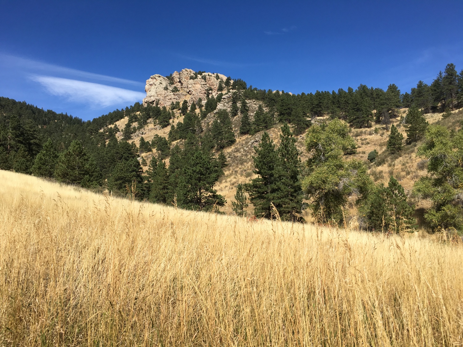


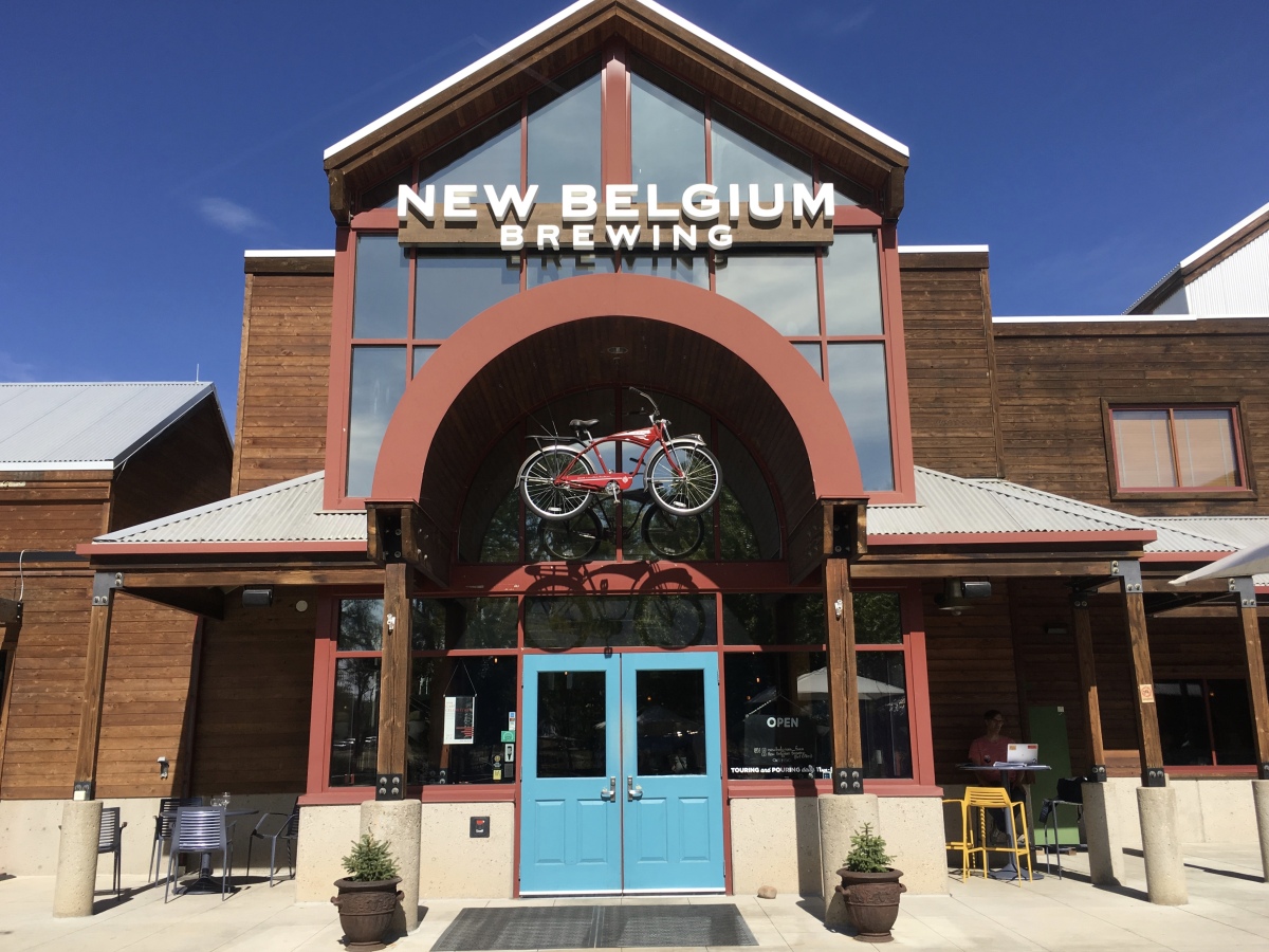


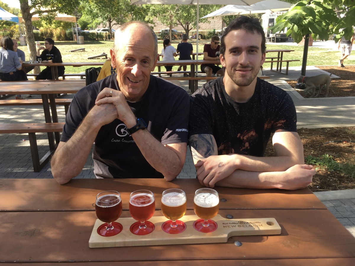
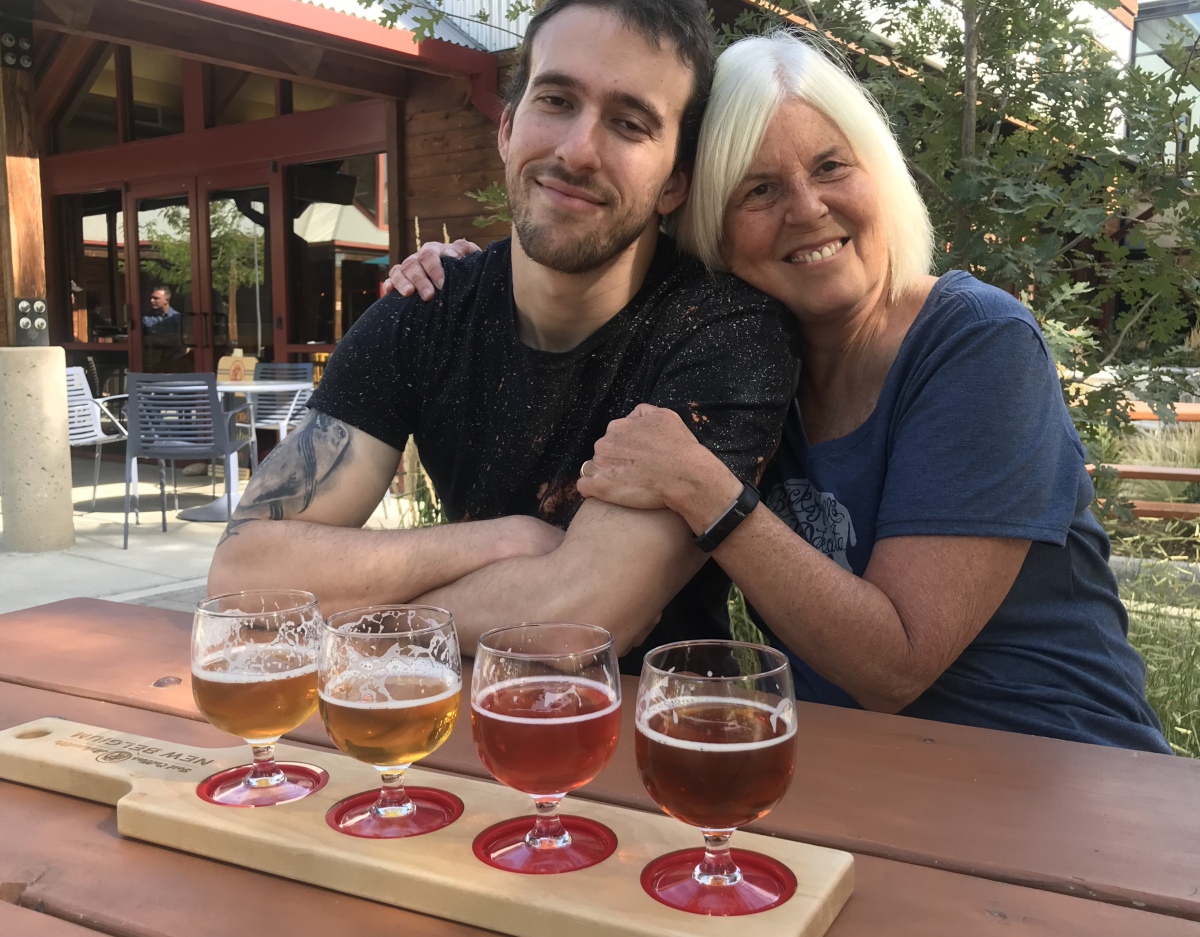
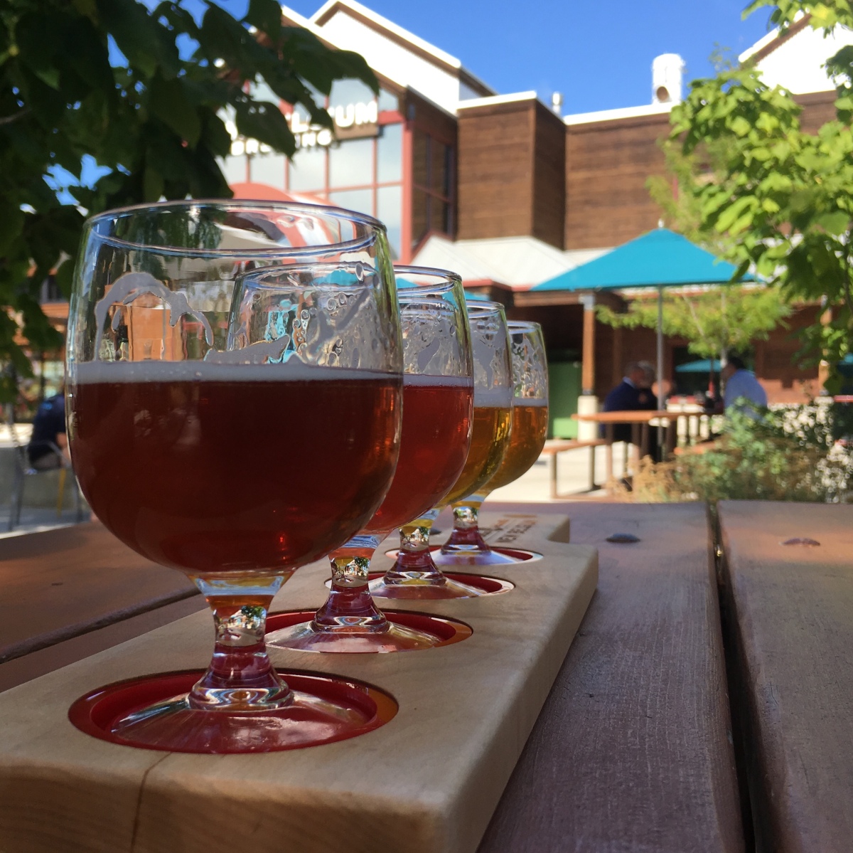
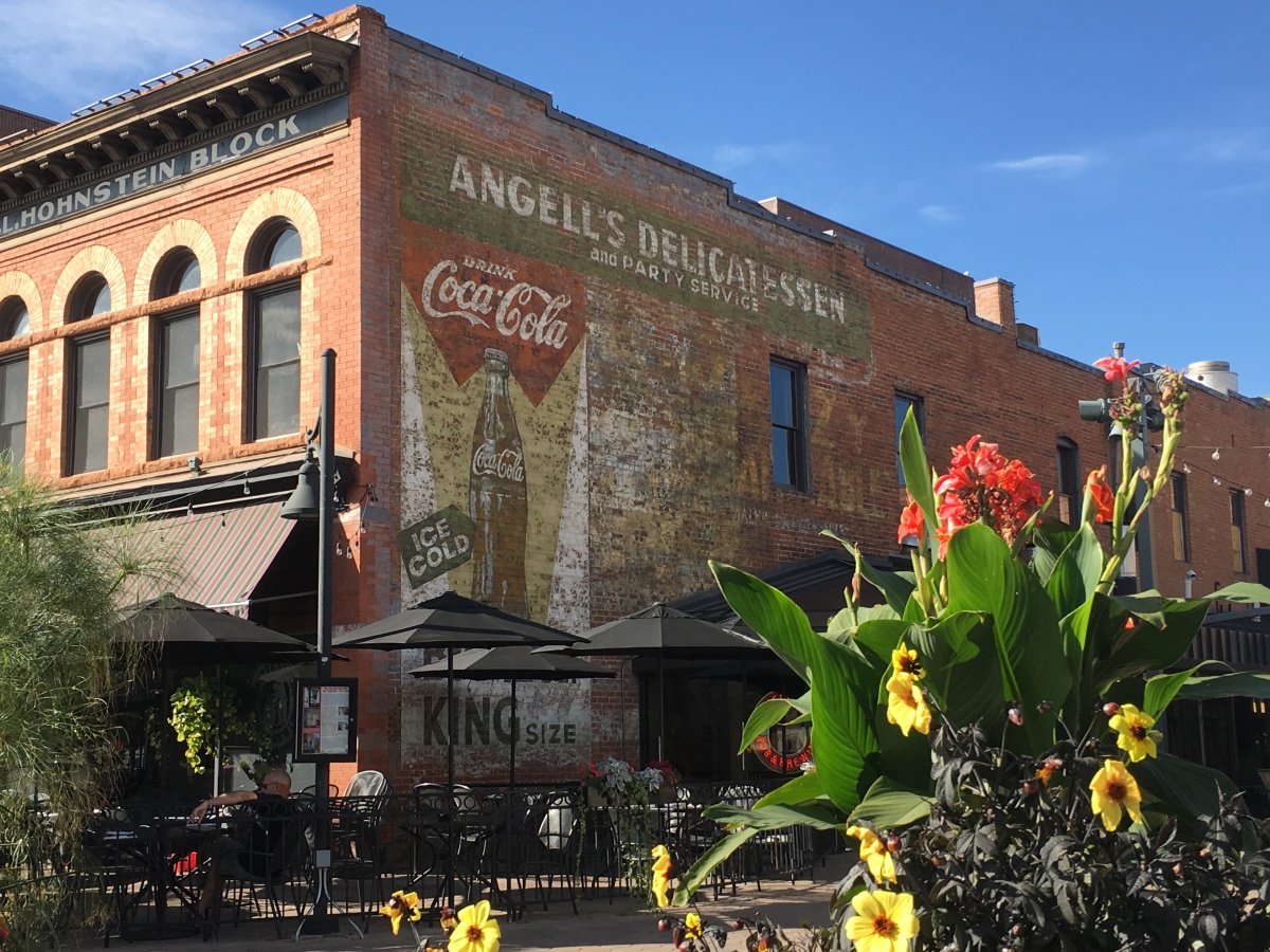
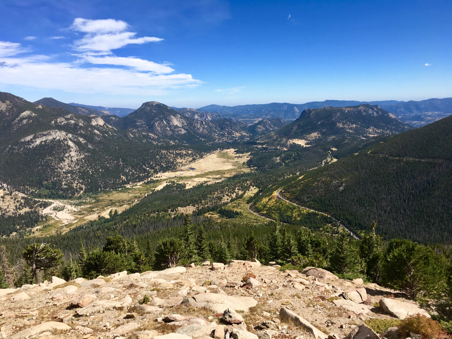


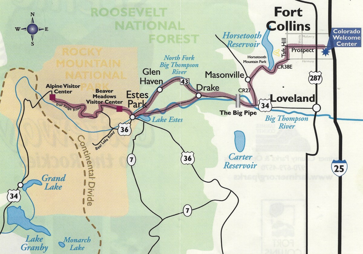


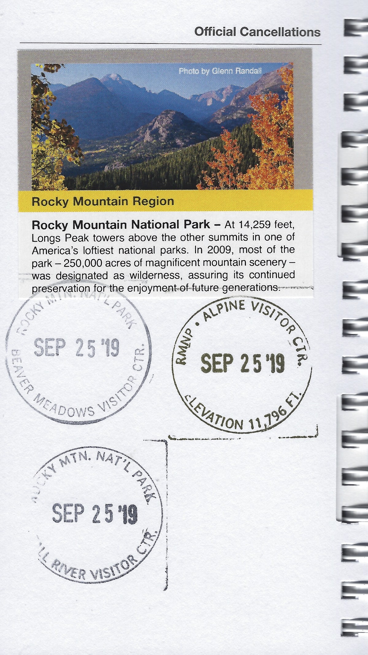


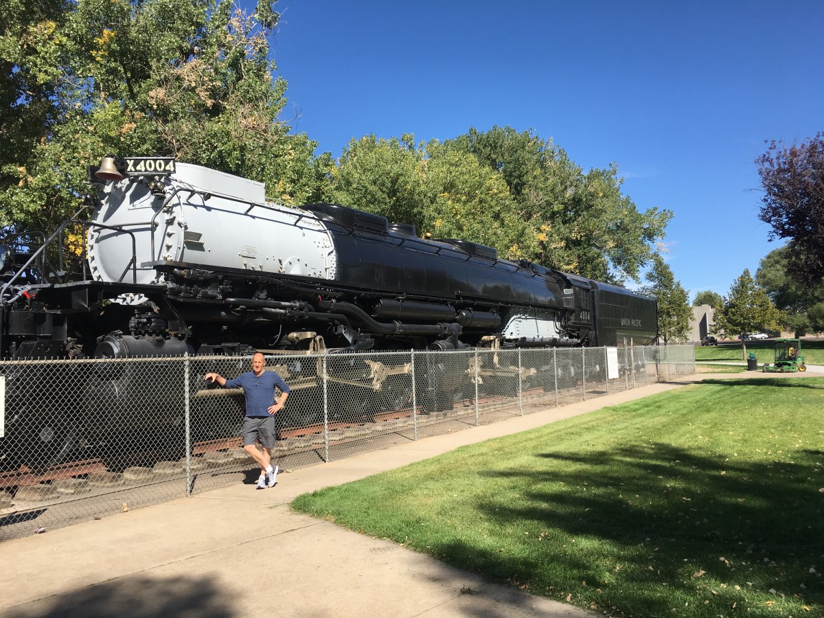


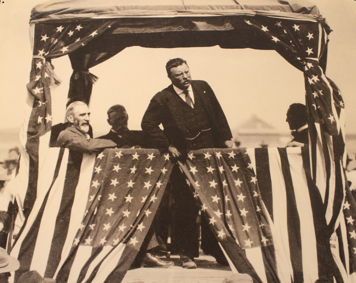


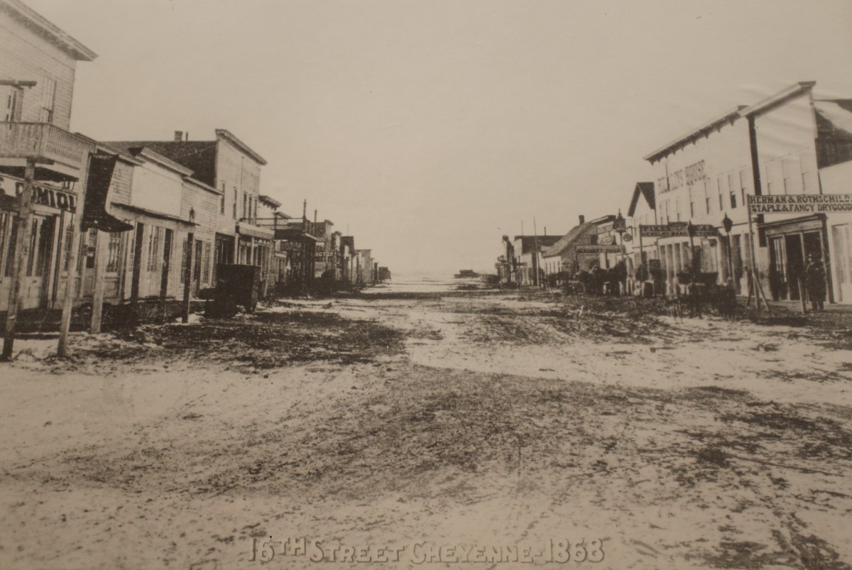
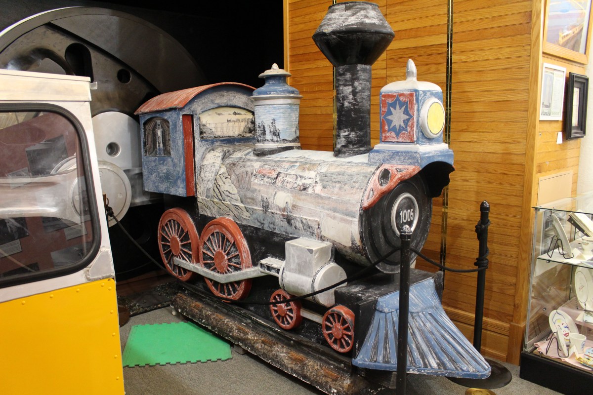


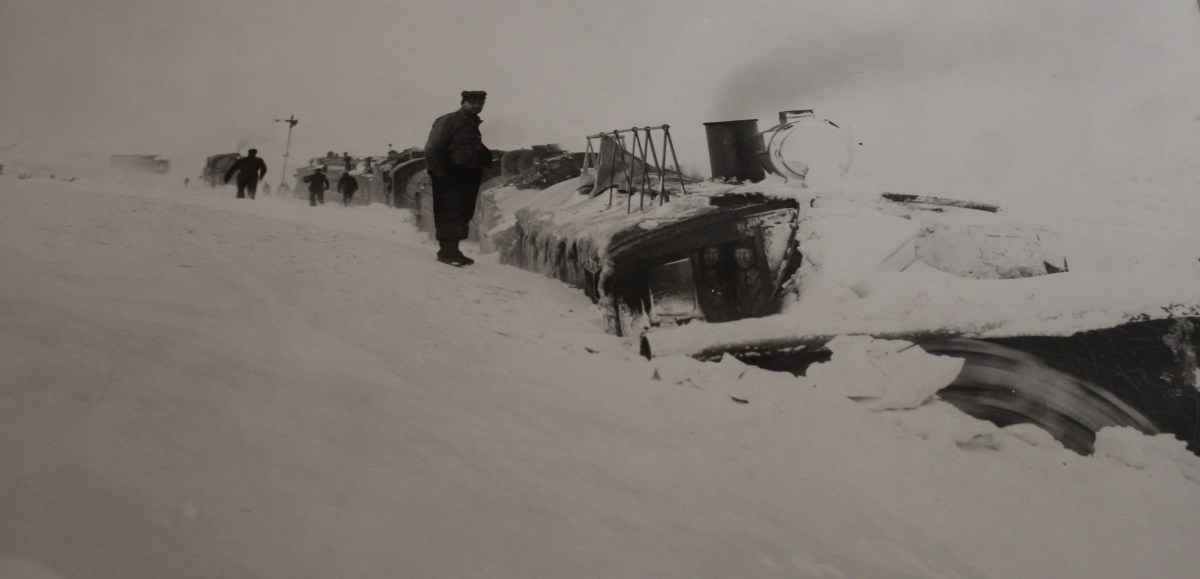


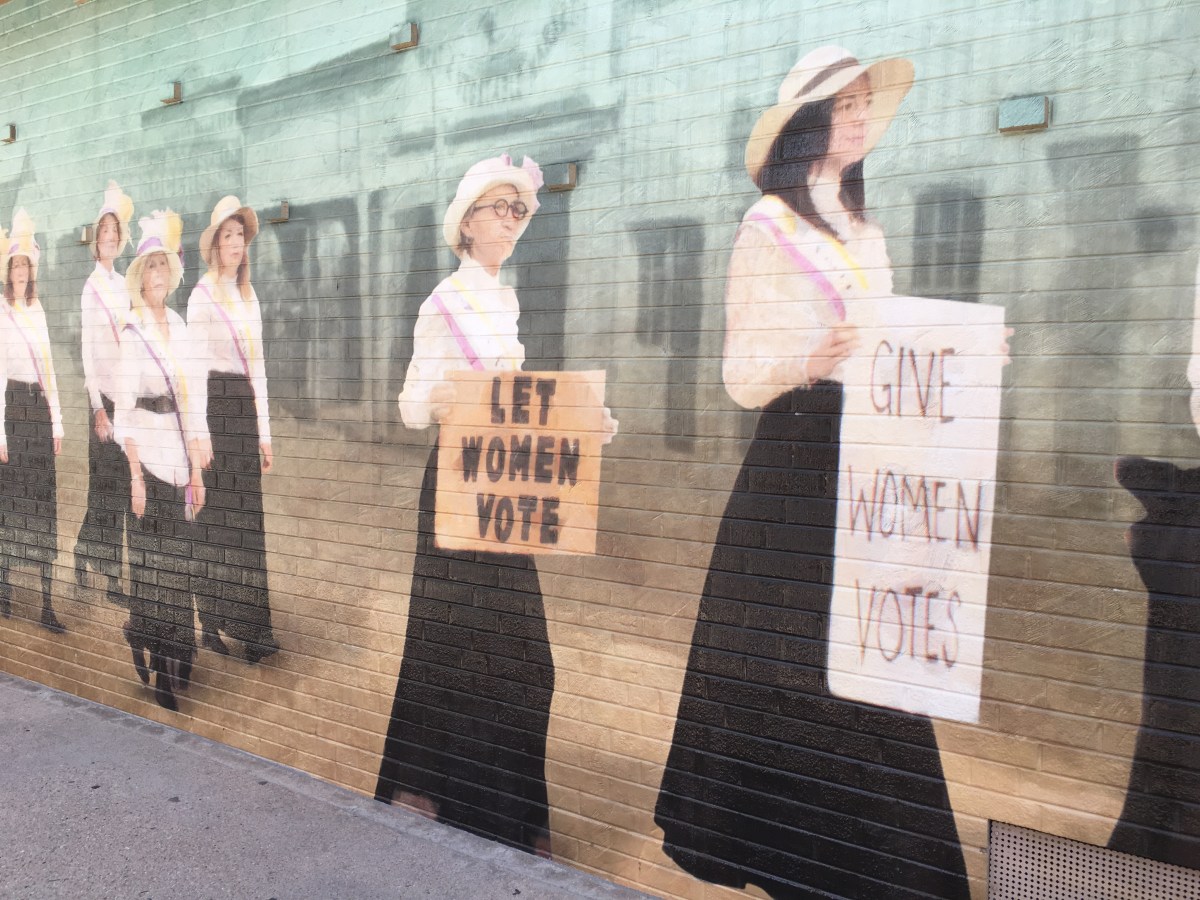

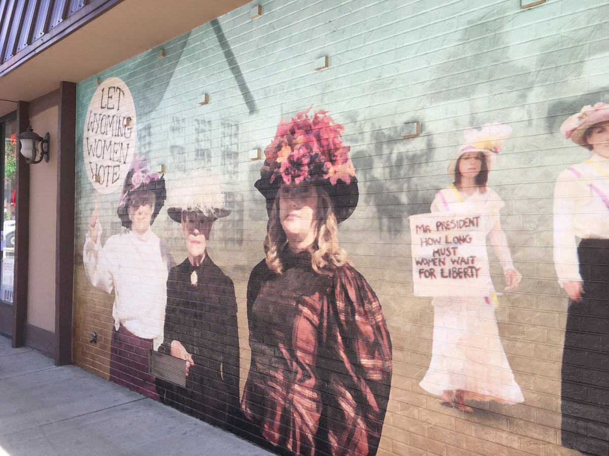
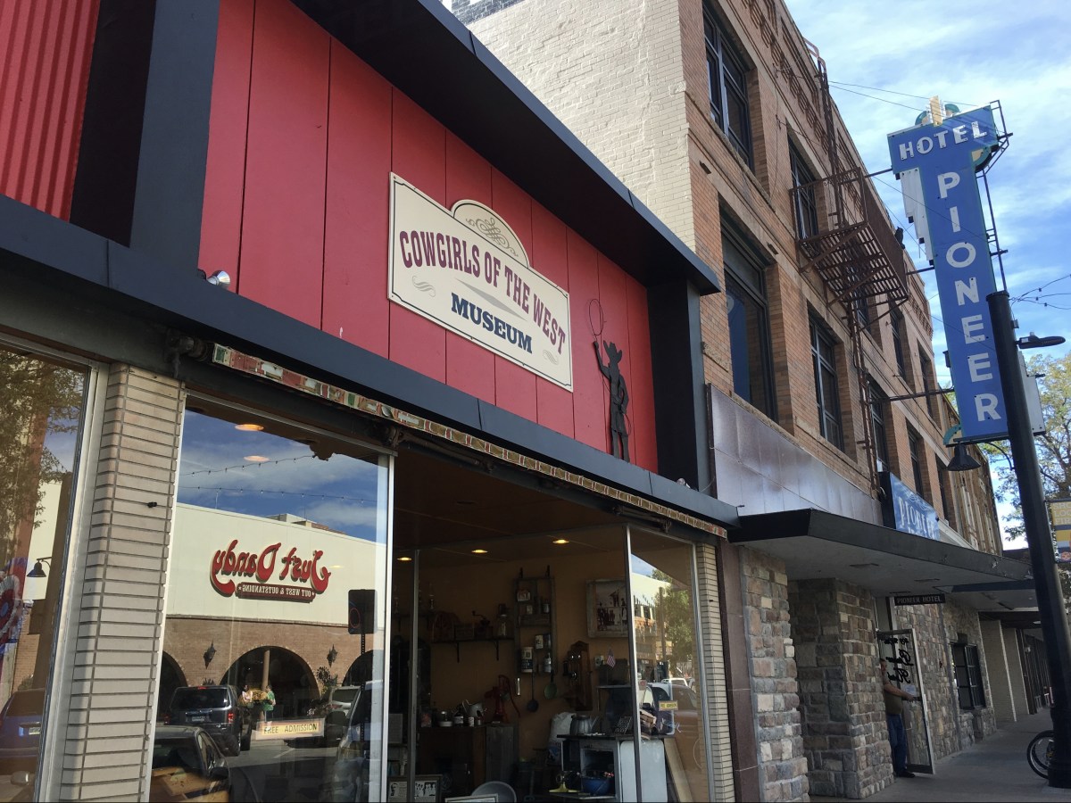


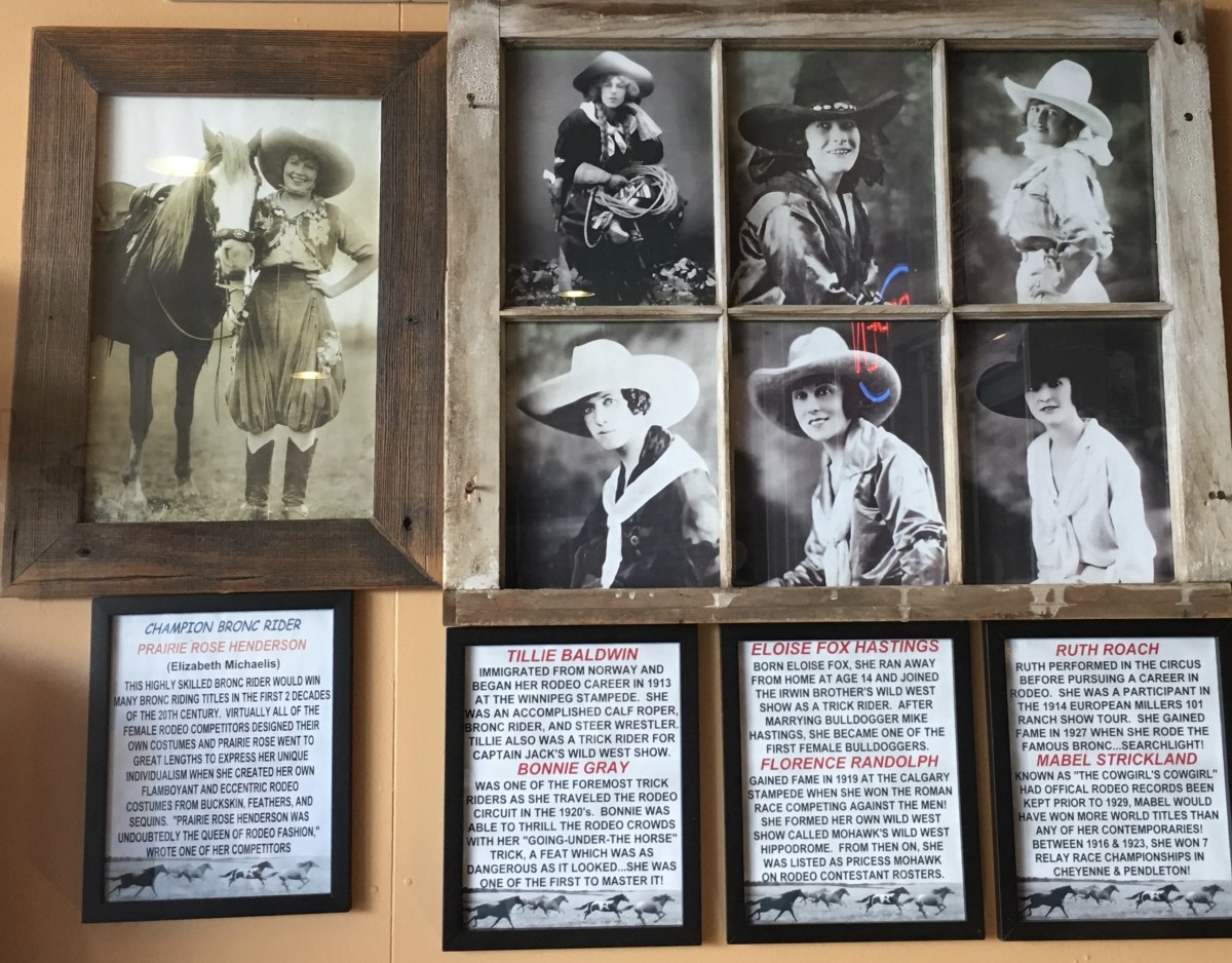

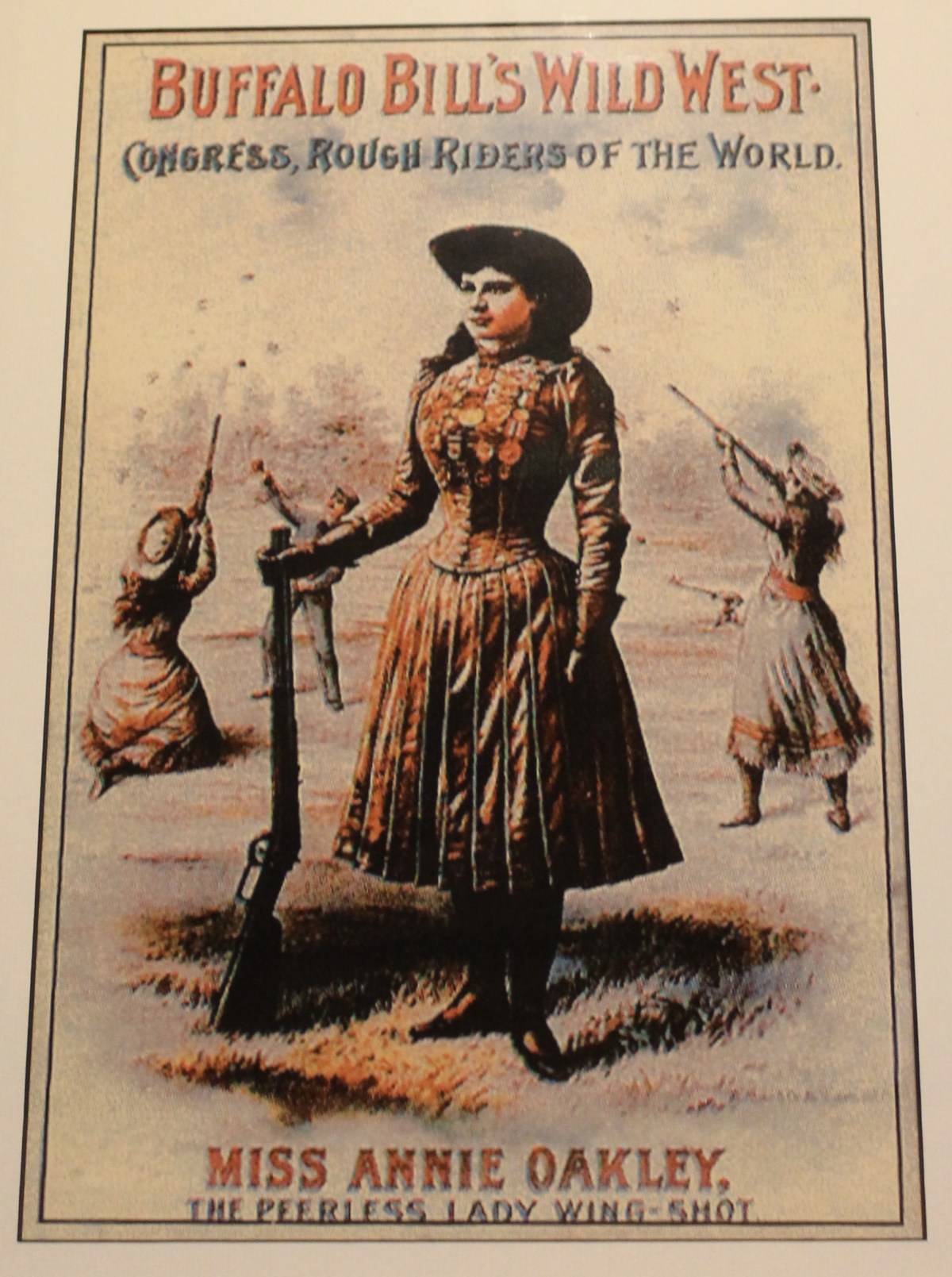
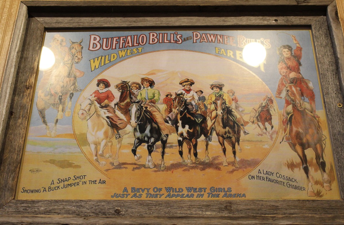


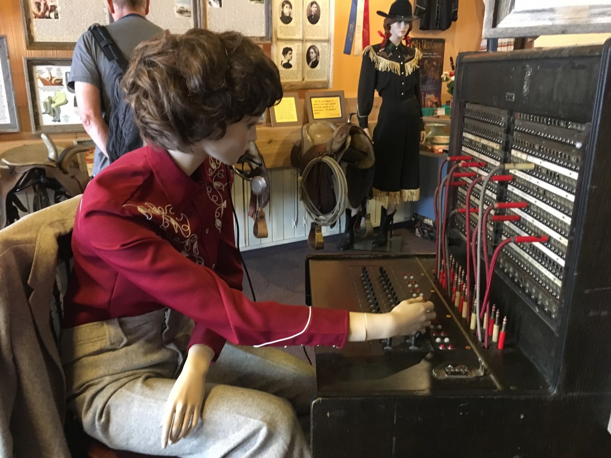
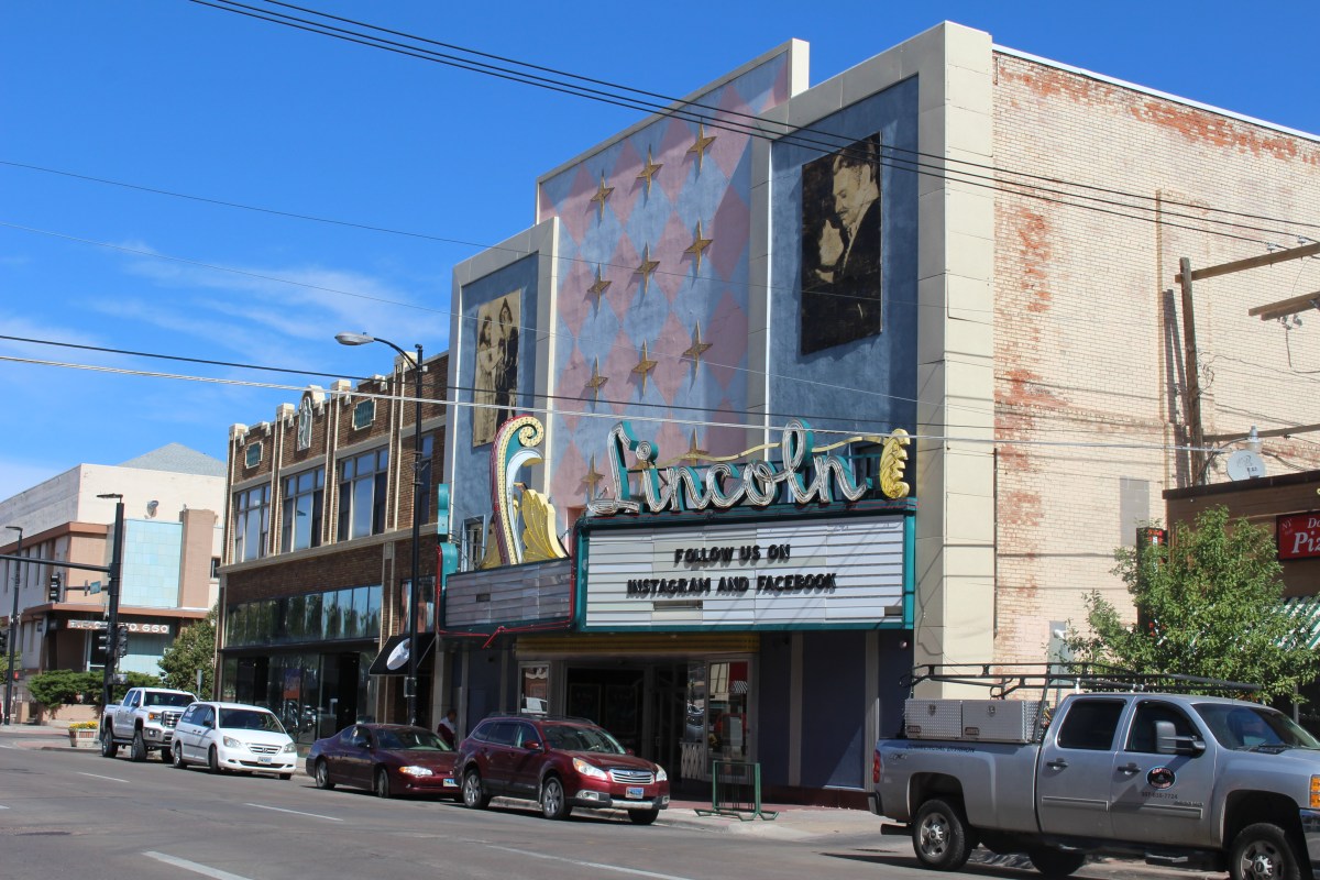


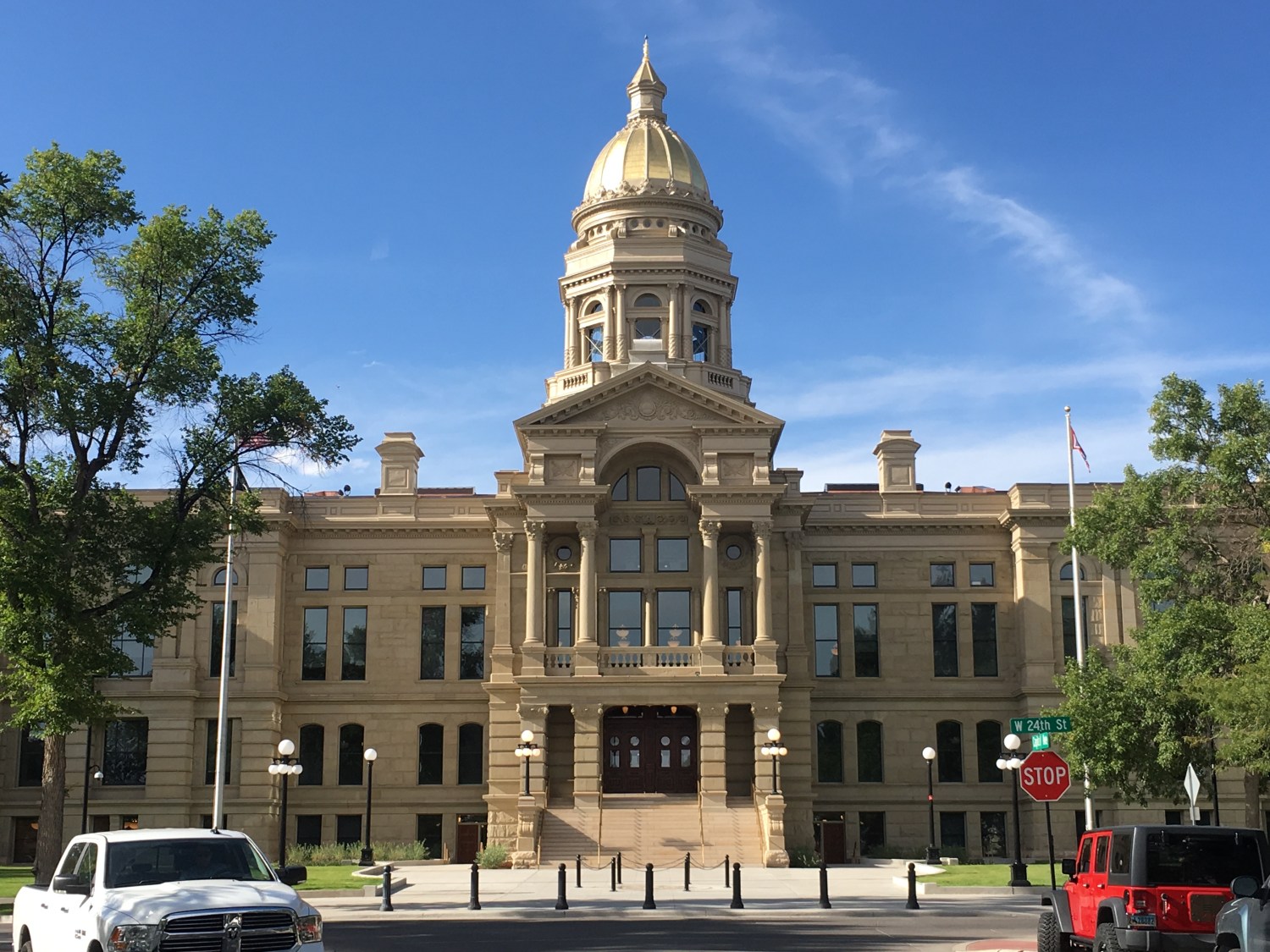


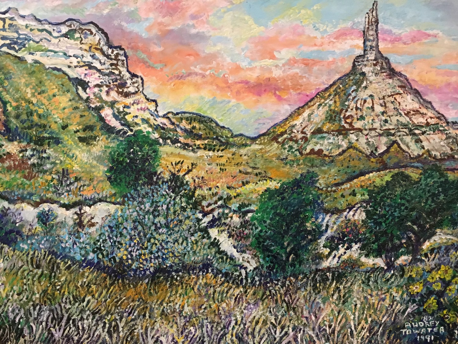
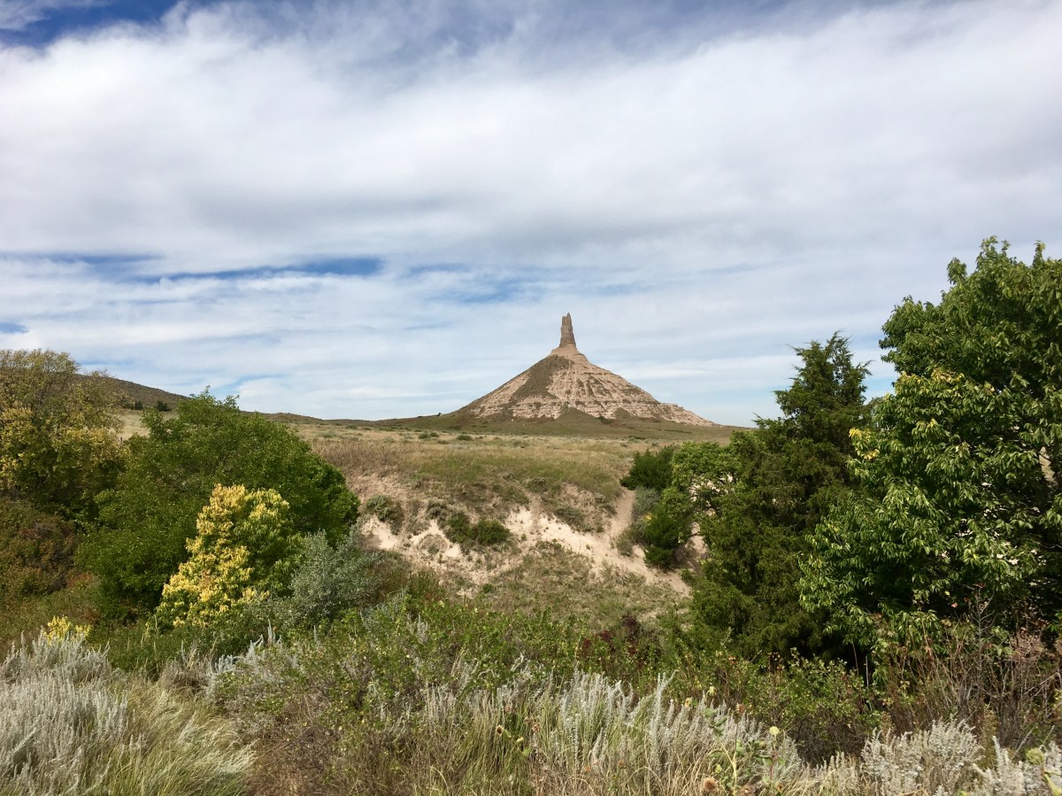


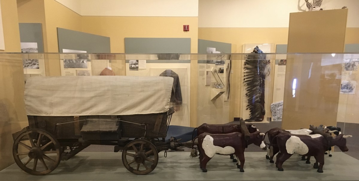
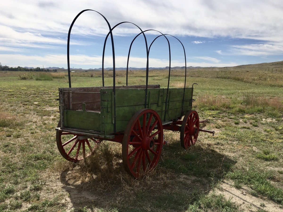


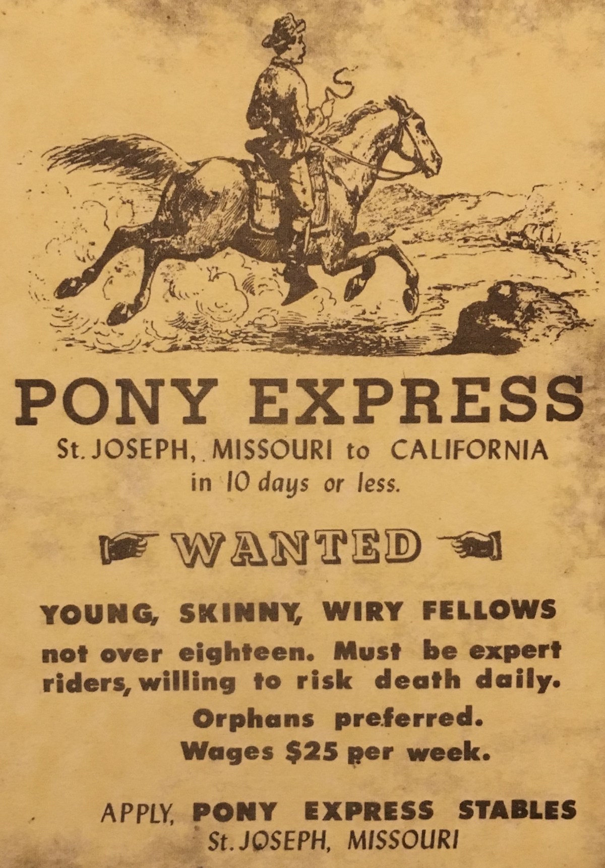
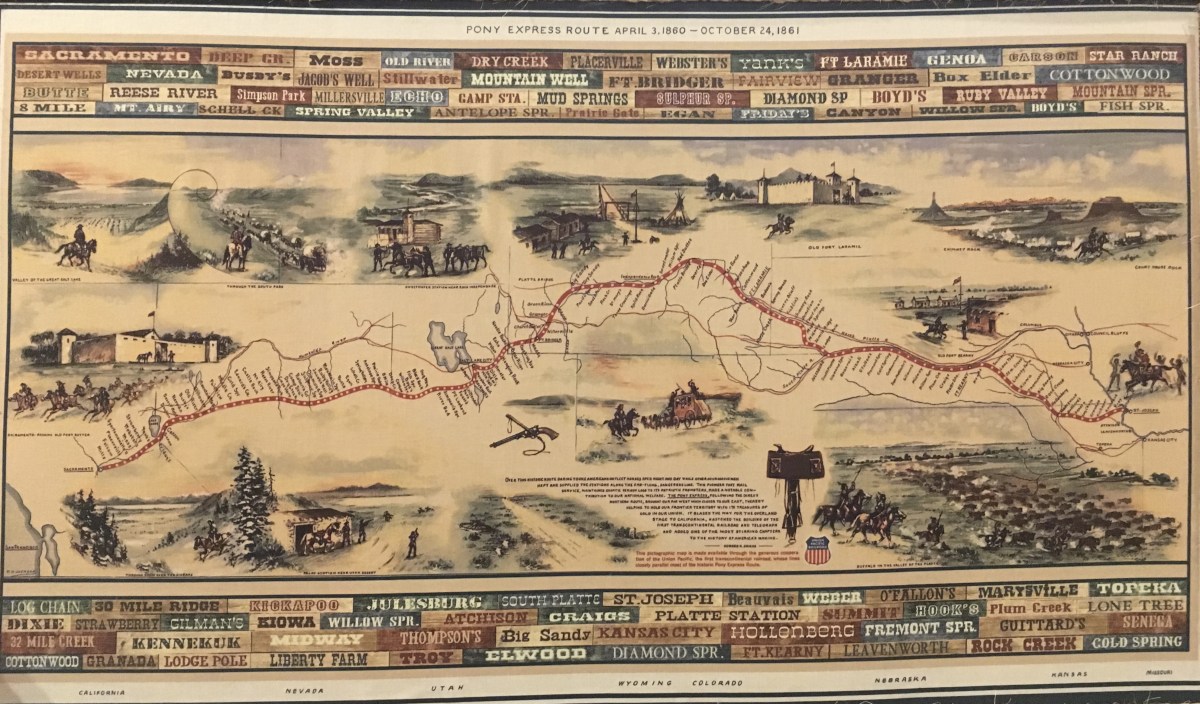


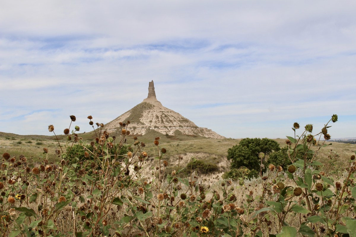
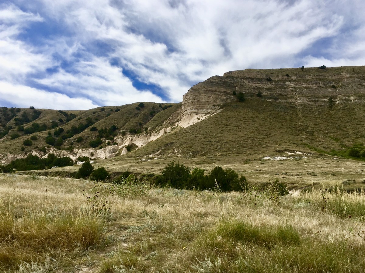


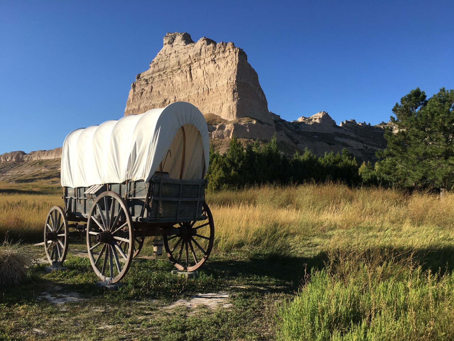


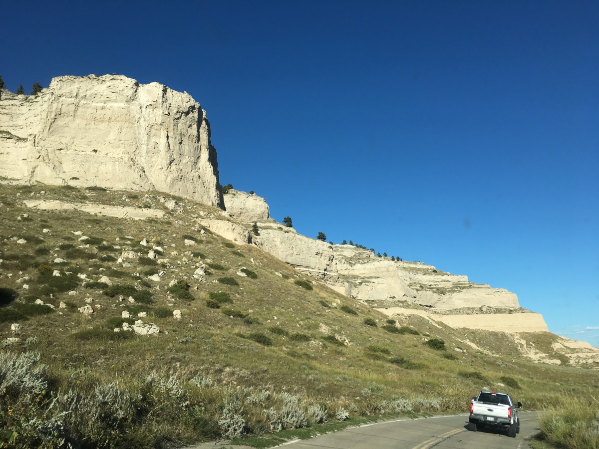


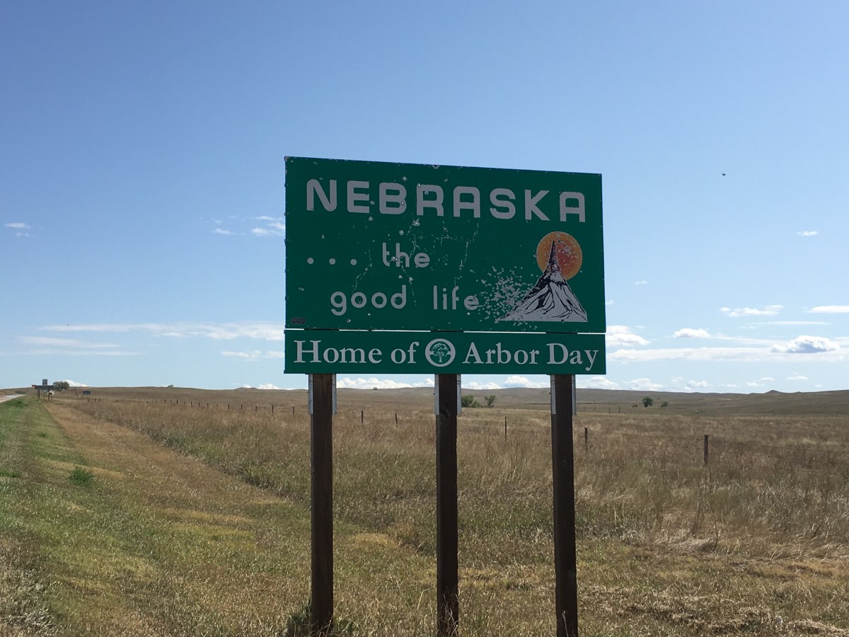


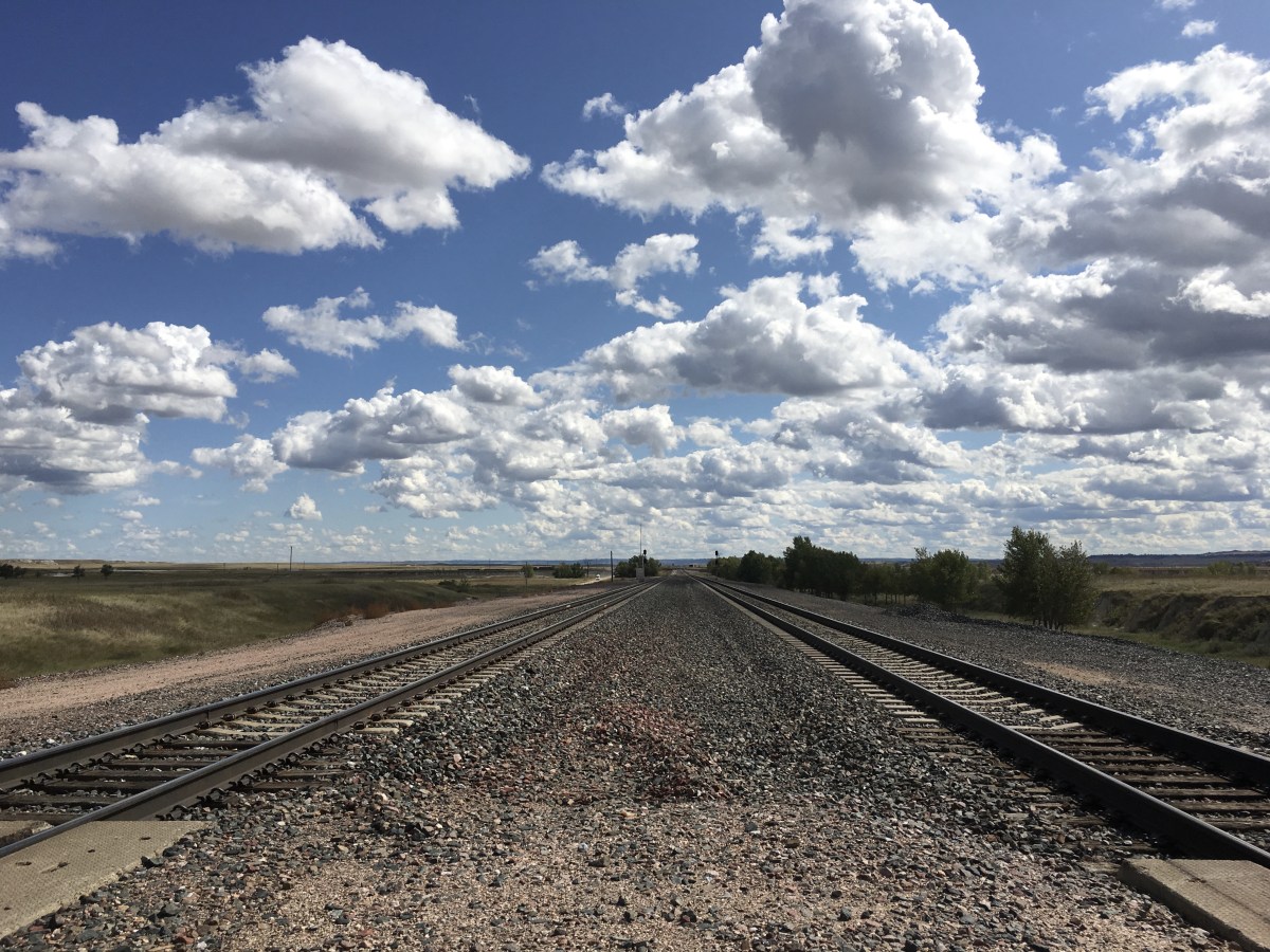

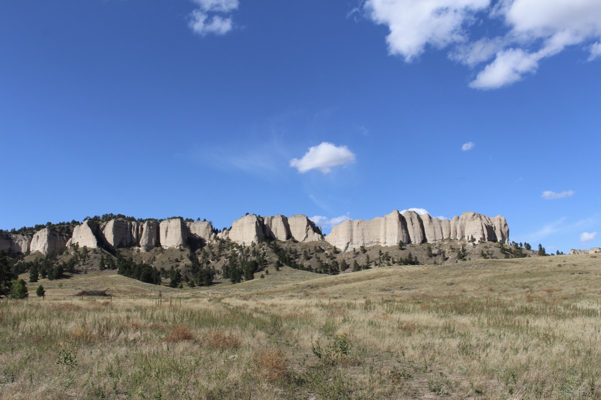
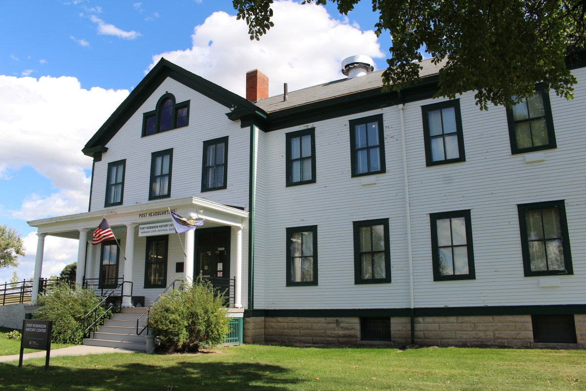
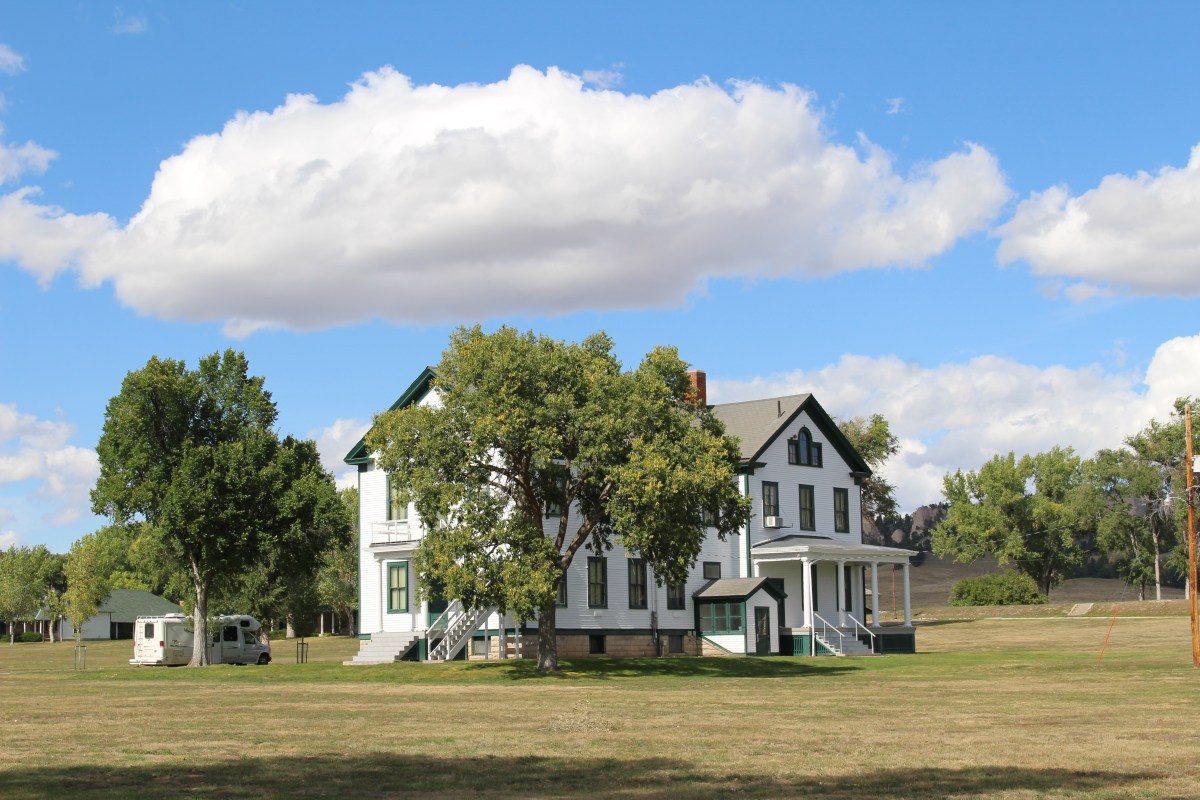


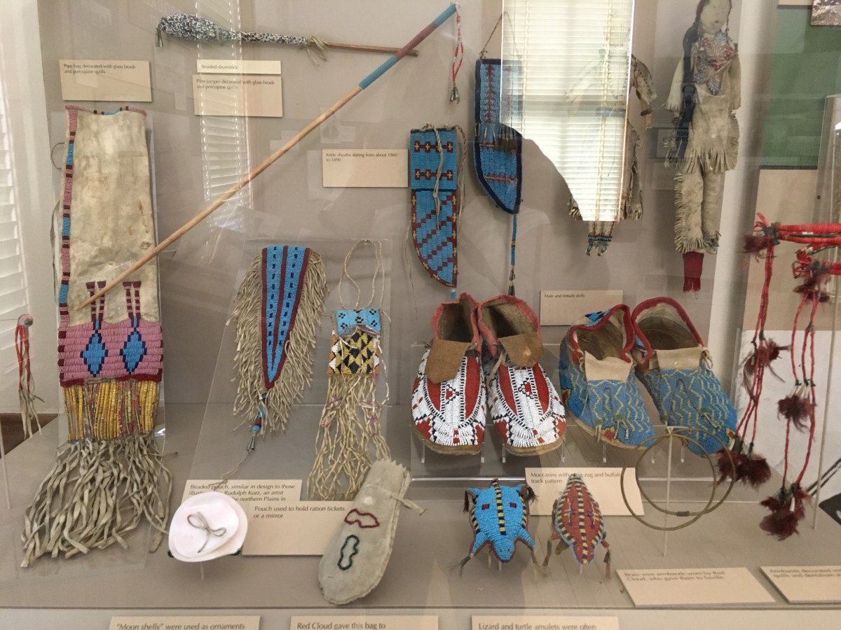
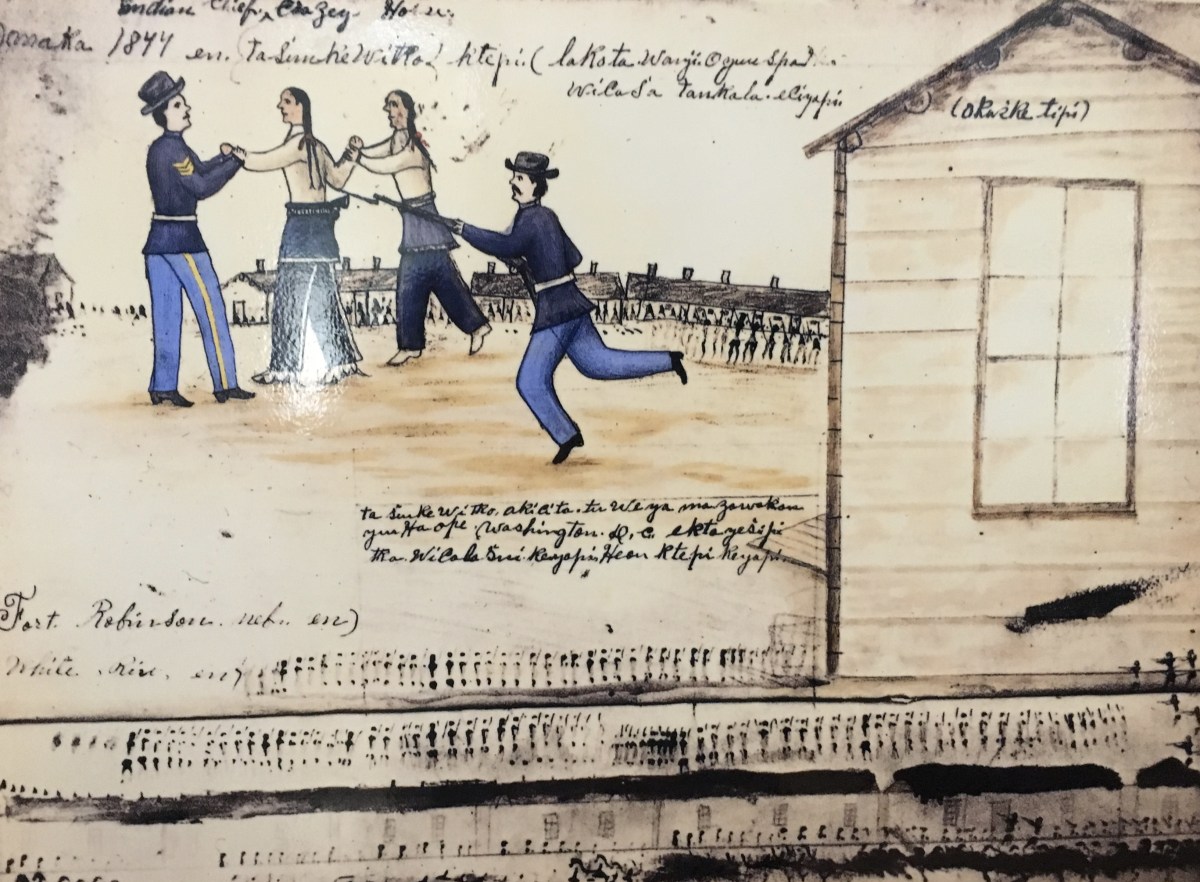


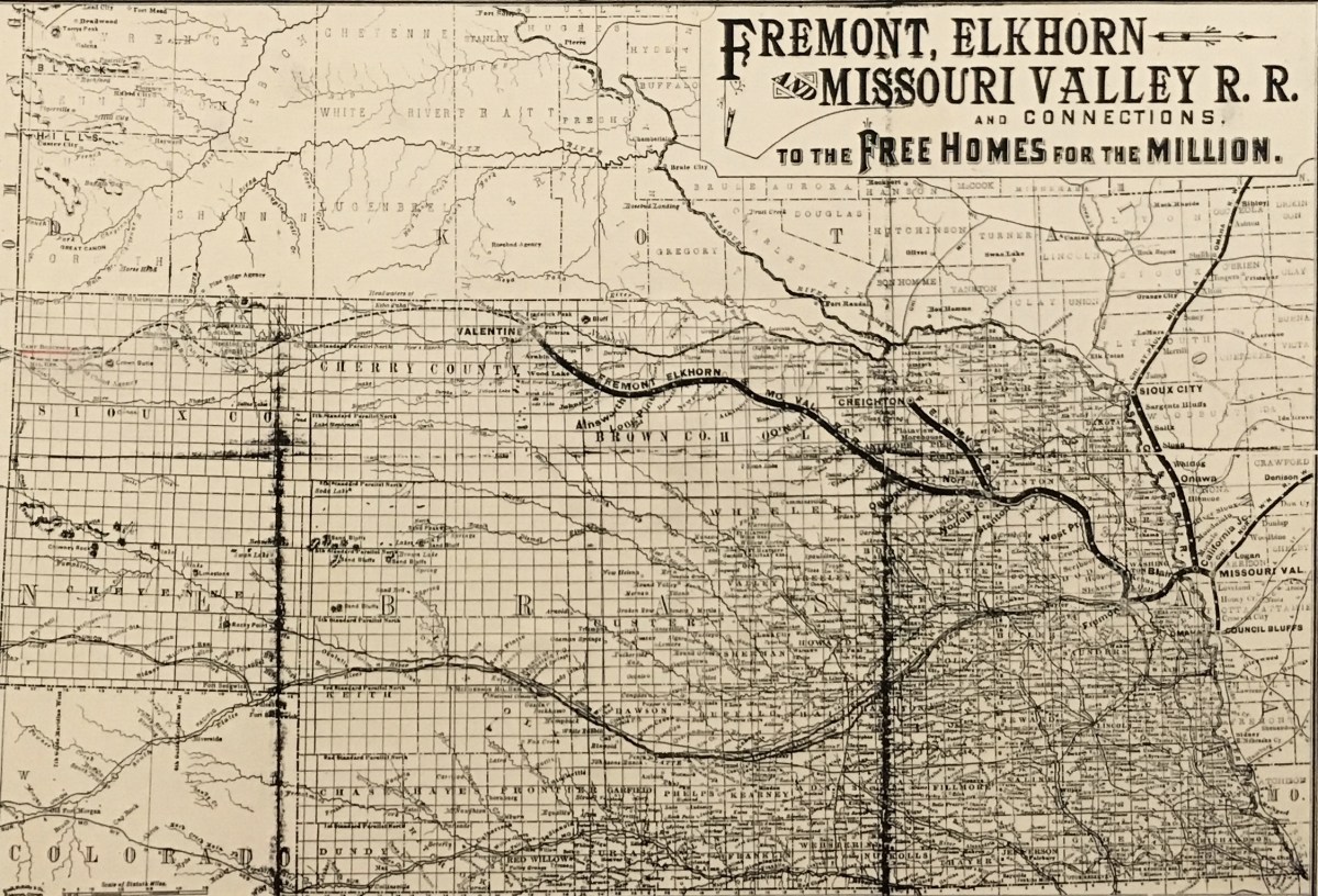


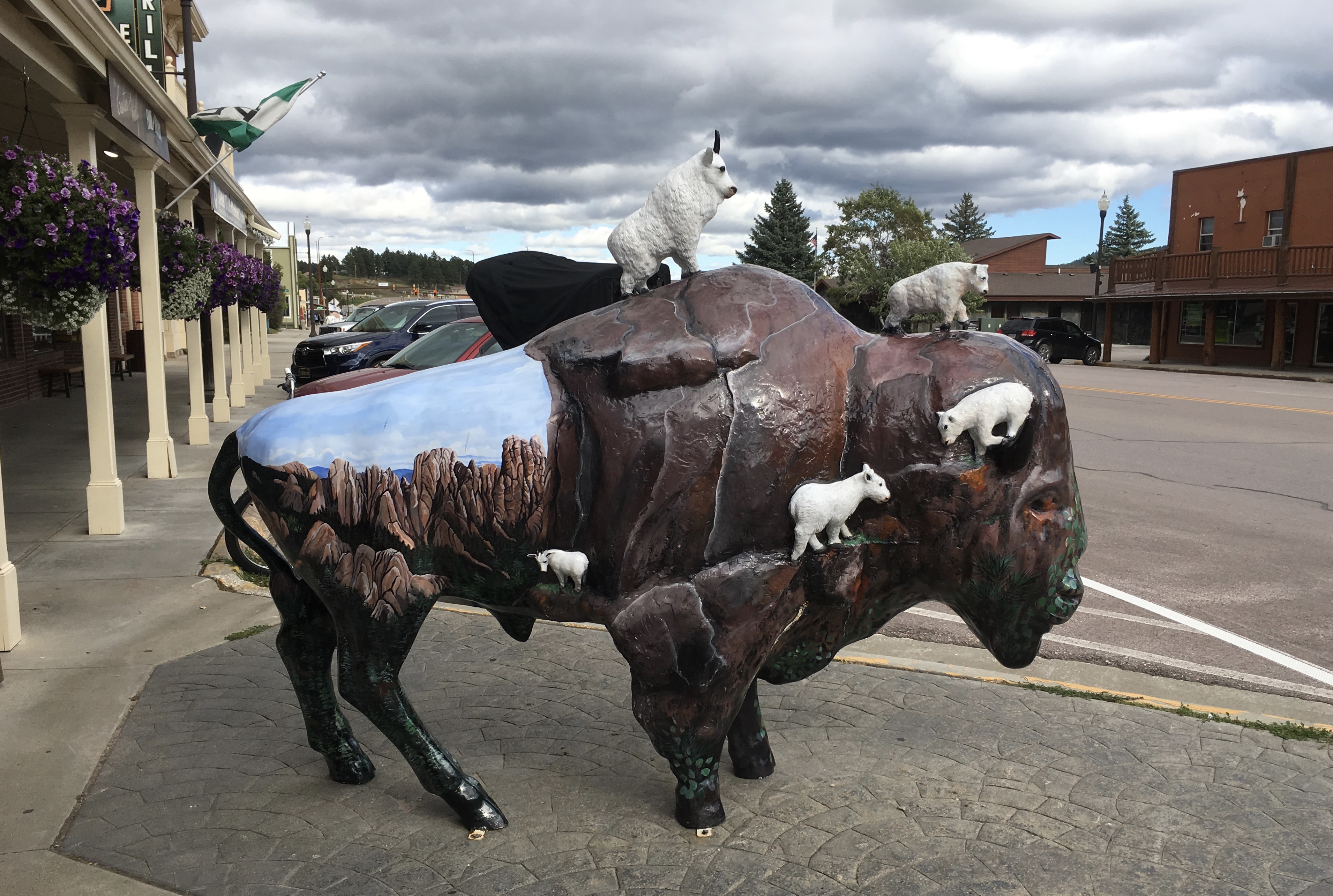


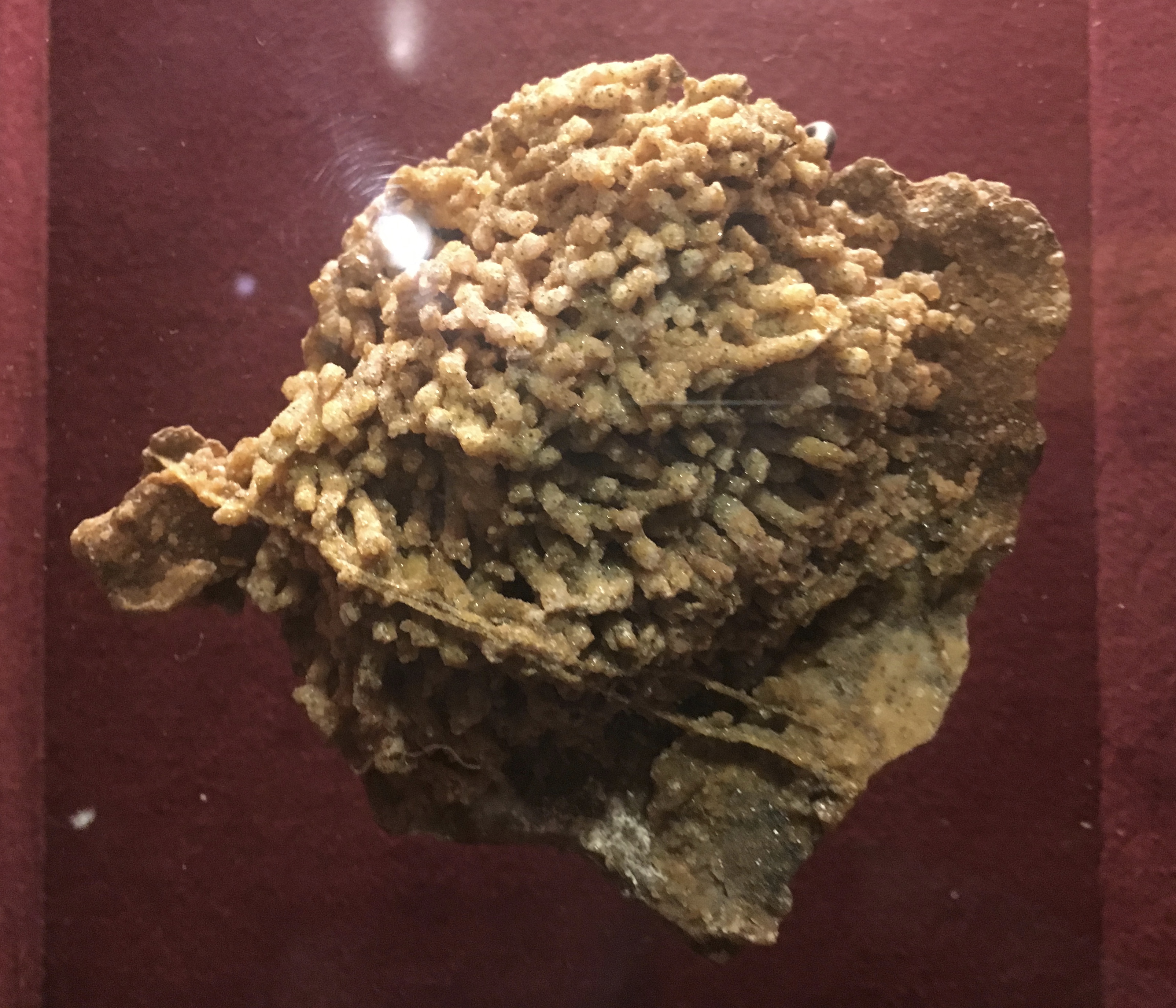

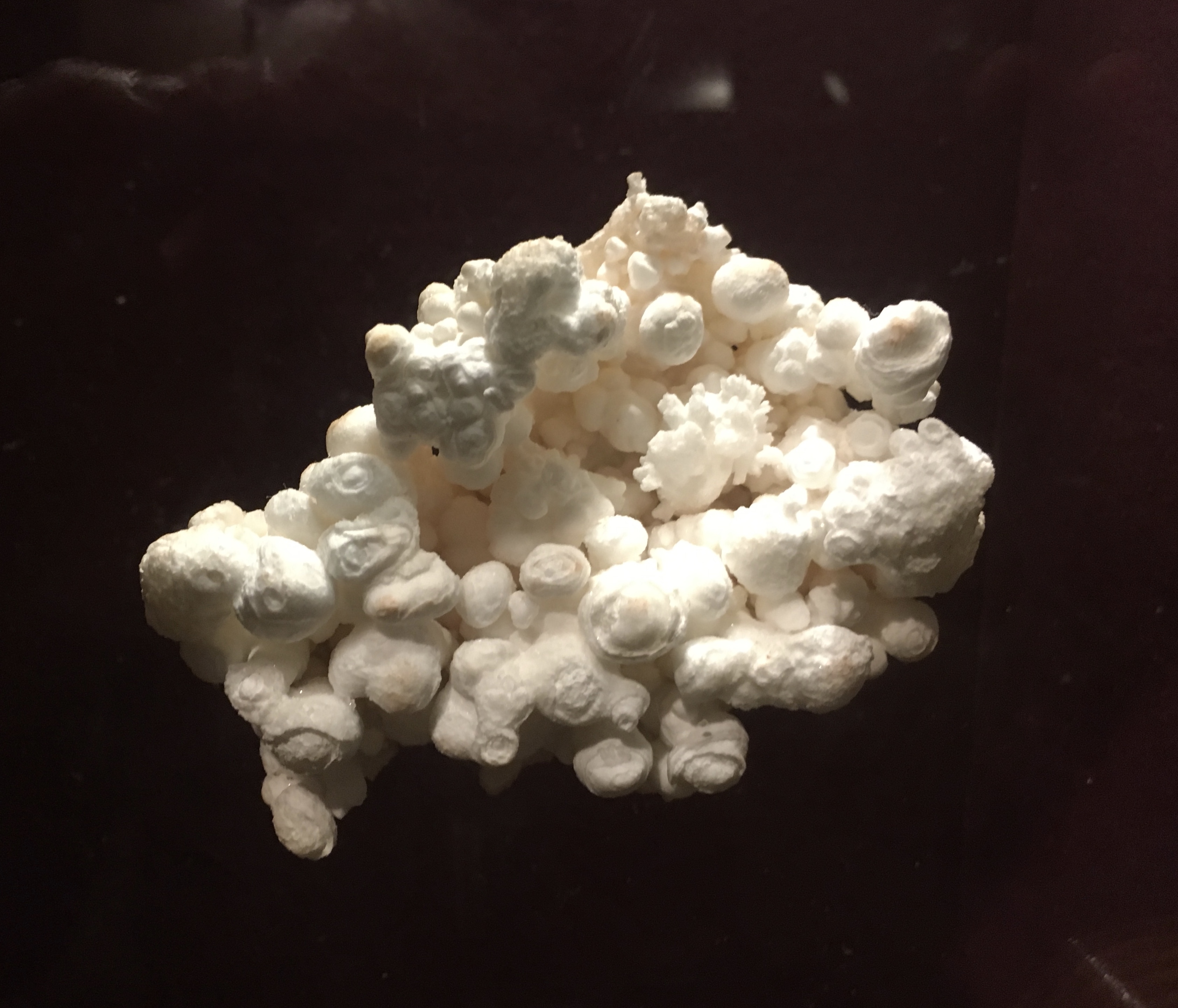


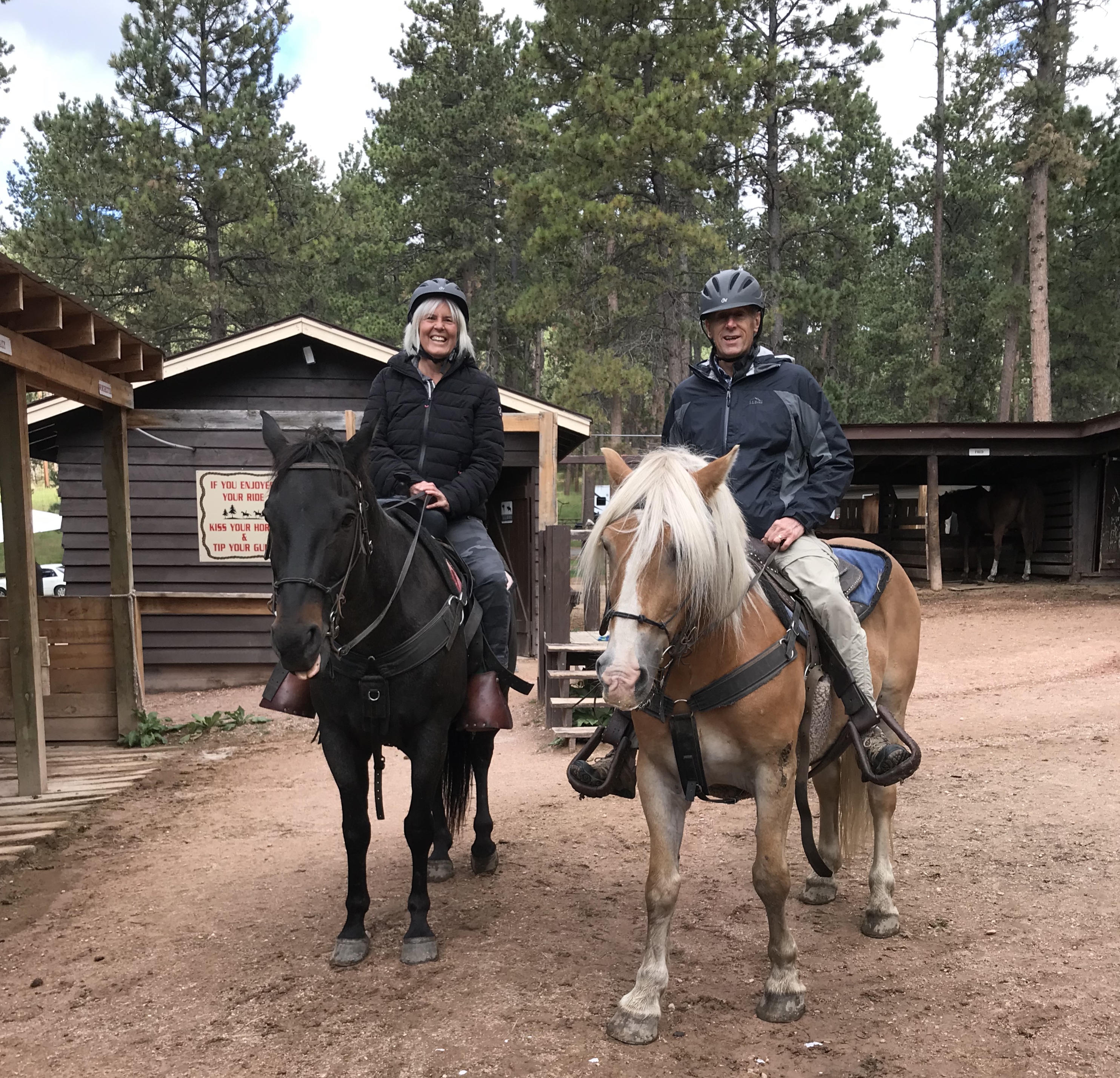


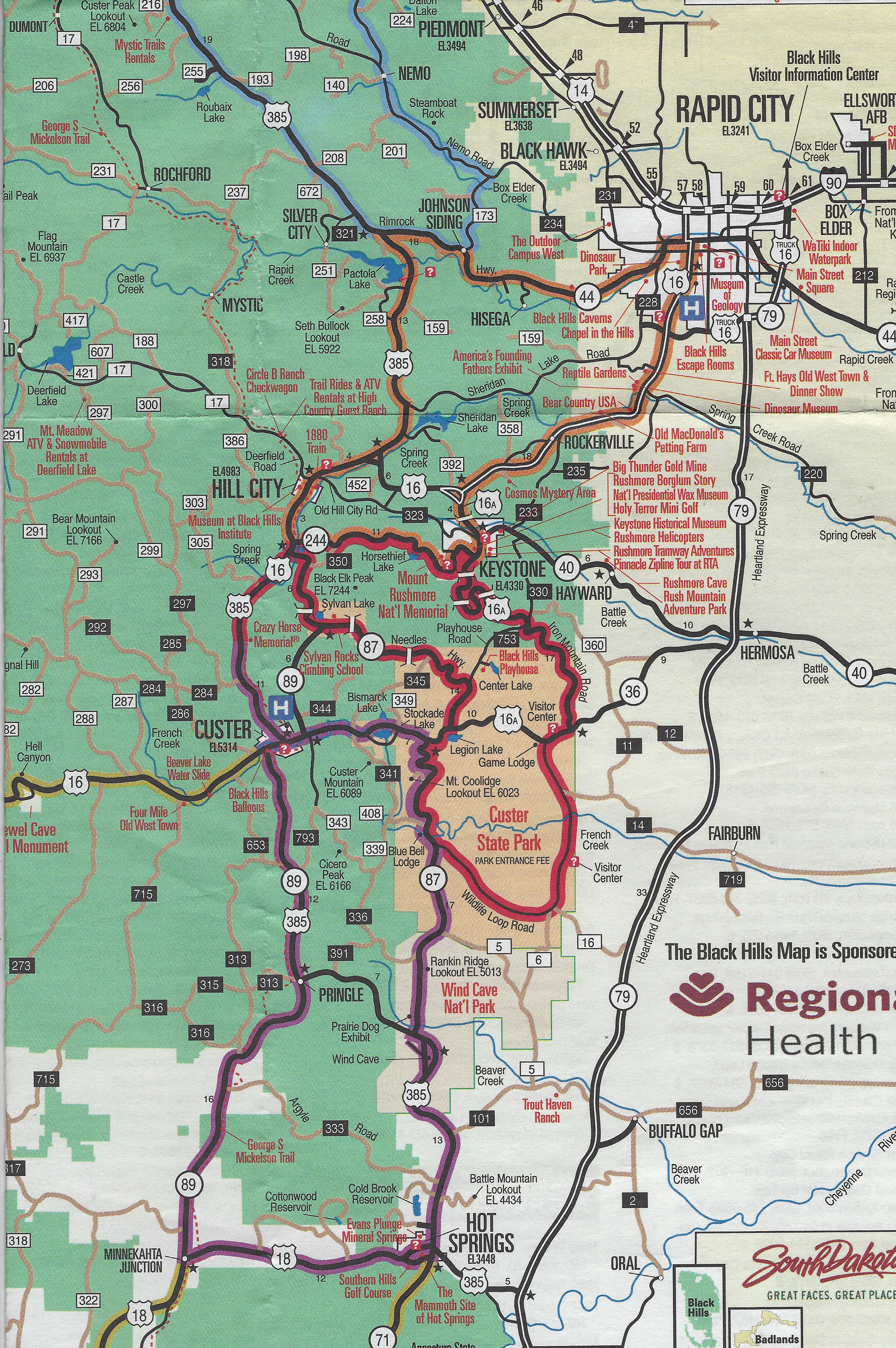

You must be logged in to post a comment.