Our final road trip for 2022 will be to The Maritimes, also called the Maritime provinces, of Eastern Canada. This region consists of three provinces: New Brunswick, Nova Scotia, and Prince Edward Island. The biggest draw for me is to see my dear friend, Lisa, who I met in Egypt in 2007. She moved to Prince Edward Island soon after Trump was elected and then invited me to visit her in 2018; at that time, I’d already made plans to walk the Camino de Santiago. I couldn’t make it north in 2019, and then of course COVID hit in 2020 and 2021 (and is still here!). Finally, I determined this year to visit Lisa in PEI, to visit the Halifax area and Cape Breton Highlands in Nova Scotia, and to visit St. John and the Bay of Fundy in New Brunswick.
One of my happiest times: Left to Right: Lisa, me, & Shannon at the Grand Cafe in Cairo in July 2007
Somehow an article online came to my attention that further cemented my desire to visit The Maritimes: “12 Top-Rated Hiking Trails in Nova Scotia.” The photos and trail descriptions in this article lured me with promises of wide open views of the sea. I have made a hike-heavy itinerary, with visits to the towns of Halifax, Charlottetown, and Saint John, as well as to Kejimkujik National Park, Cape Breton Highlands National Park, and Fundy National Park. We’ll also spend time exploring smaller villages such as Lunenburg, Cape d’Or, Ingonish (all Nova Scotia); Summerside and Victoria by the Sea (PEI); and finally Alma and St. Andrews by the Sea (New Brunswick).
Mostly, I look forward to spending some time with my hilarious friend, Lisa; walking outdoors near the sea; and eating a lot of seafood.
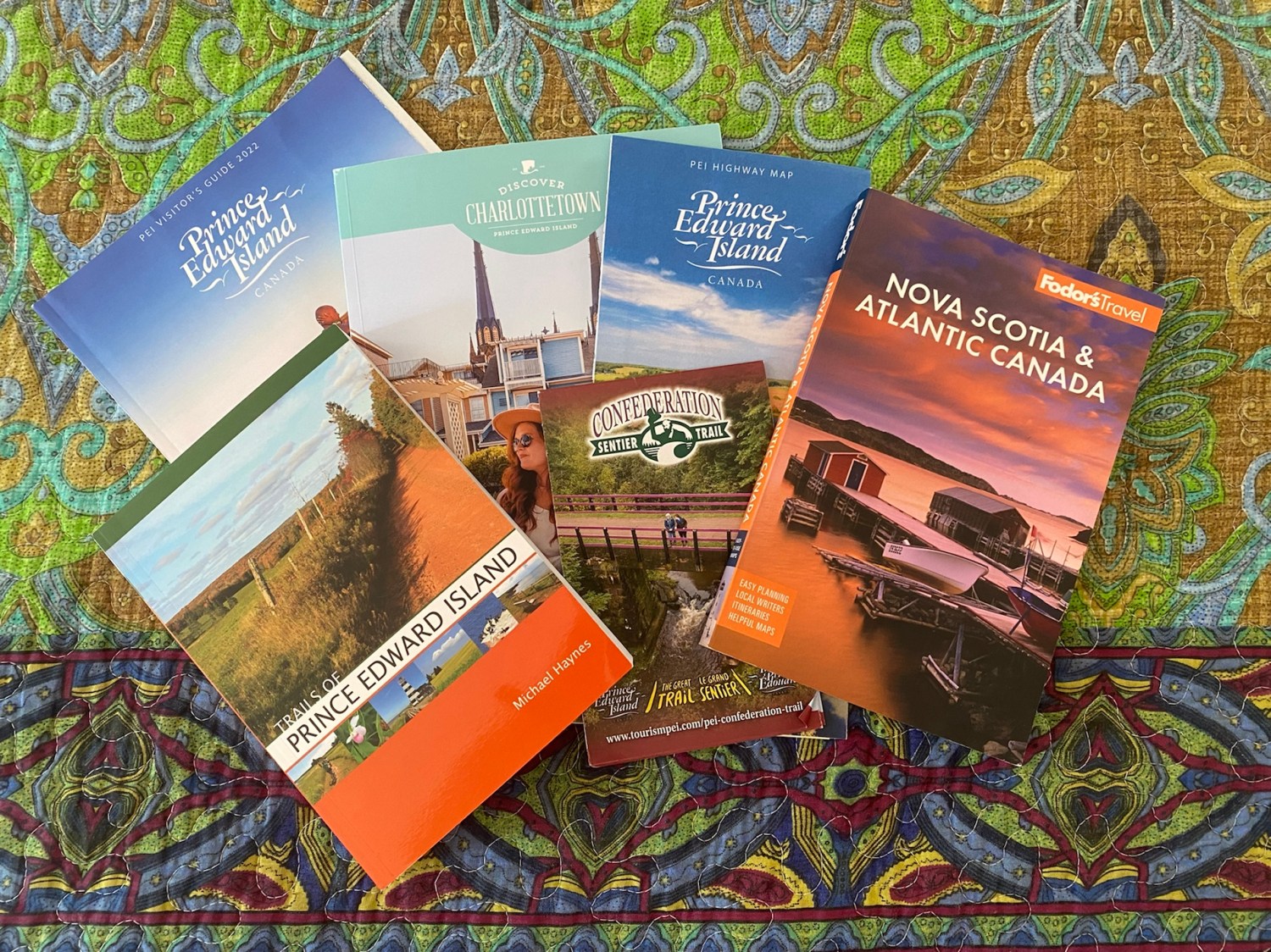
To prepare, I read Fodor’s Nova Scotia & Atlantic Canada. I have also purchased a book to bring along: Trails of Prince Edward Island by Michael Haynes. I wrote to Prince Edward Island Tourism to get more information, and from these sources and the article I found (mentioned above), I fashioned a road trip which will take, including driving time there and back, nineteen days (including four+ days of driving there and back).
Travel preparation for The Maritimes
Music
Lisa sent me some YouTube videos of Canadian music that she loves, including the following:
Besides these songs, I discovered a Canadian-Mexican musician I love: Lhasa De Sela. She sings in English, French and Spanish. Here is one of her songs: J’arrive à la ville.
And I made up my own playlist on Spotify: Canadian tunes.
Books
Of course, I always love to read books set in my destination, so I read some of the books below (indicated with stars and ratings). I own the books in green and will read them sometime during the year.
Workin’ Moms (TV series 2017-2023) **** (early seasons are best)
I prepared a journal, but it’s nothing fancy.
My journal for this trip
The Maritimes
Some things to do
a drawing of Peggy’s Cove lighthouse in Nova Scotia
The biggest obstacle we face at this point is my father’s health. He has been bedridden for the last eight months or so, and at any point things could change with him, causing us to have to cancel our plans. We are prepared to do whatever is necessary.
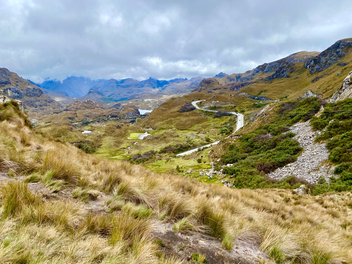
On the Wednesday during our week in Cuenca, we headed west to Parque Nacional Cajas. We drove the rental car we’d picked up at the airport the evening before, a white Toyota Yaris. When we stopped to buy some extra masks at a gas station, one of us did something to set off the car alarm and we couldn’t figure out for the life of us how to turn it off. We turned on the car, we turned off the car, we closed and opened both doors. Nothing worked. Finally we started driving through town, with the car alarm blaring away. We couldn’t figure out how to stop it and we felt like damn fools driving down the road. Finally we pulled into a parking lot, people glaring at us all around. Somehow the infernal noise stopped. We had no idea how we did it, and we resolved we’d have to go back to the airport the next day to have the rental agent check it out.
Gustavo had told us to take a sharp left at a sign for Laguna Llaviucu before we reached the actual park. We headed down the very steep and rough road. We bounced along for what seemed an eternity with no end in sight. Finally we turned around because we didn’t want to risk getting a flat on our car. Back at the top, we saw on the sign that it was 2.3km to the lake, and we’d probably gone 2/3 of the way, but by this time we’d had enough; we headed straight to the National Park.
the bumpy road to Laguna Llaviucu
cows on the road to Laguna Llaviucu
view from near the bottom at Laguna Llaviucu
Parque Nacional Cajas lies 30km west of Cuenca and encompasses 2,854 sq. km. of golden moor-like páramo (high altitude Andean grasslands) dotted with hundreds of cold lakes set in a bleak rough countryside.
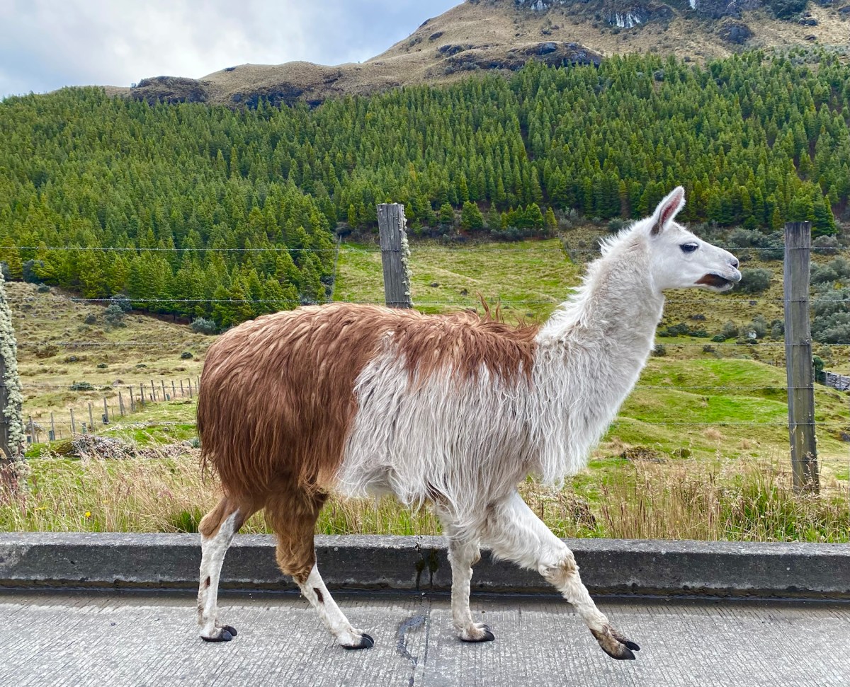
a friend we met on the road to Park Cajas
The park, a place of water, sits at altitudes over 3,100m (10,170 ft), resulting in tundra vegetation that blankets the area. A network of 786 lakes, lagoons and ponds are connected by crystal clear streams. A carpet of sponge-like plants absorb water, releasing it slowly over weeks and months. We found spongy mosses, succulents, and the amazing straw grass that is mesmerizing to behold. High altitude scenic drives reach elevations as high as 4,310m (13,550 ft).
It is doubtful that the park’s name comes from cajas (boxes) because the lakes resemble them. It’s more likely it comes from the Quichua word cassa meaning “gateway to the snowy mountains.” It could also come from caxa, the Quichua word for cold.
Cold it was. We had multiple layers on, but we weren’t quite prepared mentally for the frigid temperatures. After checking in with our passports at the park’s information center, we started our hike around Laguna Toreadora. We walked counterclockwise but in retrospect, I wished we’d gone clockwise, as most of the climbing was on the south side of the lake. Because of the elevation, I got winded every time we had to climb.
Laguna Toreadora
Laguna Toreadora
Laguna Toreadora
vegetation at Laguna Toreadora
Laguna Toreadora
Laguna Toreadora
Laguna Toreadora
Laguna Toreadora
Laguna Toreadora
Laguna Toreadora
Laguna Toreadora
Laguna Toreadora
Laguna Toreadora
hike around Laguna Toreadora
succulents at Laguna Toreadora
Laguna Toreadora
Laguna Toreadora
Laguna Toreadora
Laguna Toreadora
Laguna Toreadora
vegetation at Laguna Toreadora
mosses at Laguna Toreadora
vegetation
hike around Laguna Toreadora
spongy mosses
spongy mosses
more mosses
more sponginess
Laguna Toreadora
Laguna Toreadora
Mike in the grasses
mosses
me in the grasses
Laguna Toreadora
Laguna Toreadora
Forests of “paper trees,” also known as Polylepis trees or Quinuas, are found in sheltered hollows and natural depressions. Polylepis trees have adapted to grow at higher elevations than almost any other tree in the world.
Polylepis trees
Polylepis trees
After a good three hours of hiking, we were chilled since the weather had been cloudy, blustery and cold. We huddled over steamy hot chocolate at the café and then drove up to Mirador Tres Cruces, which marks the continental divide where the drainage basin on one side flows to the Pacific Ocean and the basin on the other side flows to the Atlantic. The road to Guayaquil goes over this pass.
Mirador Tres Cruces
Mirador Tres Cruces
Mirador Tres Cruces
Mirador Tres Cruces
Llama crossing
We drove back to our Airbnb in Cuenca, where we rested and soaked in our hot tub. I hadn’t been feeling very good, so the nice soak felt delectable.
We were so exhausted that we barely managed to drag ourselves out to dinner at El Jardín in Hotel Victoria. The place was rather deserted and a little too formal for our taste. It overlooks the Río Tomebamba, but it was too dark to see the river by the time we arrived. I enjoyed Langostinos El Jardín and Mike had an empañada and Sopa de Cebolla. We got a great night’s sleep after our rugged and active day.
Mike at El Jardín
me at El Jardín
Langostinos El Jardín
a nighttime view of the Church of San Francisco
Steps: 12,849; Miles: 5.45.
Below is a short video of the live action at Park Cajas. I suggest watching on YouTube for the best result.
We had one more full day in Cuenca, and then we would drive our trusty Toyota Yaris north on the Pan American Highway.
Tuesday, July 26, 2022: We finally made it to Quito after being waylaid in 2020 due to the pandemic and, again, in June of 2022 due to the strikes and protests by the indigenous people of Ecuador. The protests and road closures caused us to cancel our trip the Friday night before we were due to fly out on June 18. When the strikes were finally settled at the end of June, we immediately rebooked our entire trip and finally arrived in Ecuador on the afternoon of Monday, July 25.
Quito, the capital of Ecuador, has an estimated urban population of 2.8 million. It sits nestled in a valley on the eastern slopes of Pichincha, an active stratovolcano in the Andes at an elevation of 2,850 m (9,350 ft), making it the second-highest capital city in the world after La Paz, Bolivia.
It wasn’t an easy journey. We had to get up at 2:15 a.m. to catch an Uber to Reagan National Airport for a 6 a.m. flight. After a 2-hour layover in Miami, we arrived in Quito at 2:00 p.m. Our Airbnb host, Lucia, had recommended Freddy as a driver, and he deposited us from the airport to her beautiful apartment north of Mariscal Sucre. We didn’t realize it at first, but it turned out to be one of Quito’s upper-middle class neighborhoods, with plenty of good restaurants and security guards manning every building. The apartment was decorated in a bohemian style with colorful handicrafts, plenty of books, and ebullient plants.
That first afternoon, we walked downhill to the supermercado to stock up on food; the trudge back uphill carrying groceries was challenging due to the city’s high altitude. We settled in, ran out for dinner at the cute Lemongrass across the street ,and then bundled up early against the cold. During three weeks in Ecuador, we didn’t find a single accommodation with heat.
view of Quito from the plane
Lucia’s apartment
view of Quito from the apartment
Lemongrass
Best beer in the world!
Thai Bowl at Lemongrass
Taco Bowl at Lemongrass
A Walking Tour of Quito’s Centro Histórico
Quito’s Old Town, Centro Histórico, has restored Spanish colonial architecture, cobblestone streets, lively palm-fringed plazas, sing-song street vendors, 18th-century churches, and tourist police galore. Shoeshine boys were busily shining not only the shoes of businessmen, but the police’s as well. A random guy asked if he could take a picture of me, which reminded me of China, where everyone wants a picture of the gringo that sticks out like a sore thumb.
On Tuesday, we followed the “Old Town Walking Tour” from Lonely Planet Ecuador & The Galápagos Islands. Twice, once at the Plaza of San Francisco and again in the neighborhood of La Ronda, police in neon yellow vests approached us and warned us to keep our backpacks in front and not to put our phones in our pockets. We read later that Quito has about 200 “tourist police” who are bilingual and are there to keep tourists safe. Apparently the historic center is rife with crime, but we stayed aware and kept our distance from others. The walking tour kept us on the go for about 5 1/2 hours and 17,168 steps, or 7.28 miles.
Plaza Grande
Plaza Grande
Plaza Grande
Palacio de Gobierno
Palacio de Gobierno
Centro Cultural Metropolitano
Santuario de los Corazones Santísimos de Jesús y María
Centro Histórico Quito
Centro Histórico Quito
A Los Heroes Del Diez de Agosto de 1809
Banco Centro del Ecuador
Centro Histórico Quito
Plaza & Monastery of San Francisco
Centro Histórico Quito
Centro Histórico Quito
On our walk, we came upon a hat shop, Sombreros Lopez. One of my goals was to get a Panama hat in Ecuador, but Panamas are famously from Cuenca, so I had to contain myself. However, I did buy a tan felt hat, which it was too hot to wear on this day.
hats at Sombreros Lopez
hats at Sombreros Lopez
my hat – too hot to wear!
La Ronda
church in Quito
Iglesia San Augustin
We made a lunch stop at San Agustin Heladeria-Restaurante, where we each had a humita (steamed corn tamale cake wrapped in a corn husk). Mike had a pork sandwich and I had shrimp ceviche. Our biggest surprise was the smoking ice cream dish and the waiter dressed like the devil.
San Agustin Heladeria-Restaurante
humitas
smoking dessert
San Agustin Heladeria-Restaurante
San Agustin Heladeria-Restaurante
San Agustin Heladeria-Restaurante
San Agustin Heladeria-Restaurante
We continued our walking tour past the Plaza del Teatro and eventually to the Basilica del Voto Nacional, where we elevatored to the top of one of the towers and enjoyed views over Quito just as the sun came out from behind the clouds.
Basilica del Voto Nacional
view from Basilica del Voto Nacional
view from Basilica del Voto Nacional
door at Basilica del Voto Nacional
staircases at Basilica del Voto Nacional
inside Basilica del Voto Nacional
stained glass window at Basilica del Voto Nacional
inside Basilica del Voto Nacional
Finally, our first day came to an end as we walked by Plaza San Blas and soon caught an Uber back to our apartment. Later, we enjoyed a “Ham & Champ Pizza” at Bandidos del Páramo, another restaurant across the street from our apartment. We had two superb pizzas while in Quito, some of the best we’ve ever had.
Plaza San Blas
Steps: 17,168; Miles: 7.28.
Quito’s TelefériQo (a futile attempt)
Wednesday, July 27: It took us about 20 minutes to get to Quito’s TelefériQo by Uber. Ubers are in abundance in Quito, easy to use and cheap. We took the lift 2.5 km up the flanks of Volcán Pichincha to the top of Cruz Loma. At the top, we were at 4100m (13,451 feet). When we first arrived we found some cloudy views, but quickly a cold fog moved in and obscured any further views. We huddled in the café and drank Café Americano lattes and shared an empañada with plantain, chili and queso. We realized the futility of hoping for any views and headed back down the mountain.
TelefériQo
heading up
Polylepis shrubs
views from Cruz Loma on a cloudy day
me at the viewpoint
Polylepis shrubs
views from Cruz Loma
views from Cruz Loma
cafe at the top
La Floresta
We took a taxi to La Floresta, an artsy neighborhood, where we had a fabulous and beautifully-presented lunch at Casa Warmi. What a pleasant experience. The restaurant was adorable with its golden wood floors, a wall of ivy with a mounted bicycle, and a tree growing through a hole in the roof. We enjoyed corn chowder with queso, yucca fritters with raw tuna embellished with flowers, and cevichocho (ceviche with a kind of grain – chochos – and red onion and avocado). Yum!
Casa Warmi
Yucca fritters with tuna
Cevichocho
Mike on a chair with fancy feet
After lunch we walked around La Floresta, a quirky neighborhood with charming cafés, painted planters, an abandoned ruined house with an abundance of plants, and an adorable café/theater, 8cho y Media: “Siempre tendemos Paris” (We’ll always have Paris). Inside had mid-century modern decor with comfortable seating areas and movie posters. We enjoyed espressos and shared a giant chocolate chip cookie. From there we caught an Uber to Casa Museo Guayasamin.
La Floresta
La Floresta
La Floresta
La Floresta
La Floresta
8cho y Media
8cho y Media
8cho y Media
8cho y Media
8cho y Media
8cho y Media
8cho y Media
Casa Museo Guayasamín
Casa Museo Guayasamín is the former home of Oswaldo Guayasamín (1919-1999), an Ecuadorian painter and sculptor of Kichwa and Mestizo heritage. The museum houses his work and the home mostly houses his collection of pre-Columbian ceramic, bone, and metal pieces. The pieces are arranged by theme – bowls, fertility figurines, burial masks, etc. The museum also houses the artist’s collection of religious art, including works by highly-skilled indigenous artists from the Quito School. There’s even a collection of bloody crucifixes; despite being an aetheist, the artist often featured tortured Christlike figures in his own work.
He explored themes of oppression in the lower classes, racism, poverty, Latin American lifestyle, and human and social inequalities. His work focused on subjects who symbolized all human suffering.
Guayasamín built the museum in Quito that features his work. He also built the stunning house where he lived and worked. Seeing Guayasamín’s home and studio was the highlight of the tour. We watched a video of him vigorously painting a famous musician (the long yellow “towering” face shown in the video – see below). I loved seeing the huge table he used as a palette, the moveable stairs he used to do his large paintings, the paints and oversized brushes. We saw a self-portrait of the artist done at an early age and his library. One collection showed him with his mother, his greatest love. He was married three times and had seven children.
Guayasamín was buried with his best friend under a pine tree in his yard overlooking Quito. The grounds of his house, and the museum below the house, sit at a high point in Quito and overlook the city. It’s a gorgeous site.
Oswaldo Guayasamín
Casa Museo Guayasamín
Casa Museo Guayasamín
Casa Museo Guayasamín
Casa Museo Guayasamín
Casa Museo Guayasamín
Casa Museo Guayasamín
Casa Museo Guayasamín
Casa Museo Guayasamín
Casa Museo Guayasamín
Casa Museo Guayasamín
Casa Museo Guayasamín
Casa Museo Guayasamín
Casa Museo Guayasamín
the artist’s studio
the artist’s studio
the artist’s studio
Casa Museo Guayasamín
Casa Museo Guayasamín
Casa Museo Guayasamín
Casa Museo Guayasamín
Casa Museo Guayasamín
Casa Museo Guayasamín
Back at the apartment, Mike captured me relaxing on the sofa under a blanket, writing in my journal. Later we mustered our energy to walk a steep set of stairs to look for a restaurant on Avenue Gonzales Suarez. We finally ate dinner at Lucia’s House, a restaurant on the edge of La Floresta. I enjoyed an Ensalada Mexicana and Mike had corn chowder with bacon. We walked back to the apartment.
me relaxing in our cozy apartment
Ensalada Mexicana
Steps: 7,561; Miles: 3.21.
Termas de Papallacta
Thursday, July 28: Freddy picked us up and drove us over the mountains and the Papallacta Pass, an hour and a quarter southeast of Quito, to Termas de Papallacta. Neither Mike nor I were feeling that great and we had scheduled massages. Mike enjoyed a deep body massage while I regretted my choice of a hot stone massage; mine was disappointingly low pressure. I wished I’d booked the deep tissue massage because my back had been killing me since Tuesday morning for no discernible reason.
The baths were in a tranquil setting surrounded by mountains, including Volcán Antisana. The town is high in the Andes at around 3400m in elevation.
We went into the hot pools with differing temperatures and tried them all. I enjoyed the hottest ones the most since the air was cold and it was a gray day. The resort was in a deep bowl with mountains all around.
Termas de Papallacta
Termas de Papallacta
Termas de Papallacta
Termas de Papallacta
Termas de Papallacta
Termas de Papallacta
Termas de Papallacta
tree at Termas Papallacta
It was all very relaxing and nice to get away from the hubbub of Quito but the best part was the drive over the mountainous landscape with our driver Freddy. He was keen to speak English and we were keen to speak Spanish, so we had many fascinating conversations using our bungled languages, interspersed with words from both languages and using Google translate when necessary to communicate. Freddy was driving over mountain passes and in the middle of traffic speaking into his phone for translations and we didn’t feel the slightest bit of concern over his multitasking. We loved our time with Freddy!
The view over the mountain pass coming back from Termas Papallacta
We got home and relaxed for a good long while. Later, we climbed the two blocks uphill to Avenue Gonzales Suarez to look for a place to eat. We stopped at a pharmacy, where we bought a thermometer and Claritin, then walked down the street, poking our heads into Hotel Quito for a view of the gorge.
We enjoyed a nice dinner at Lucia’s House. I had an Ensalada Mexicana and Mike had corn chowder with bacon. We walked back to our apartment in the dark.
Steps: 7,646; Miles: 3.21.
Quito’s TelefériQo (Second time’s a charm!)
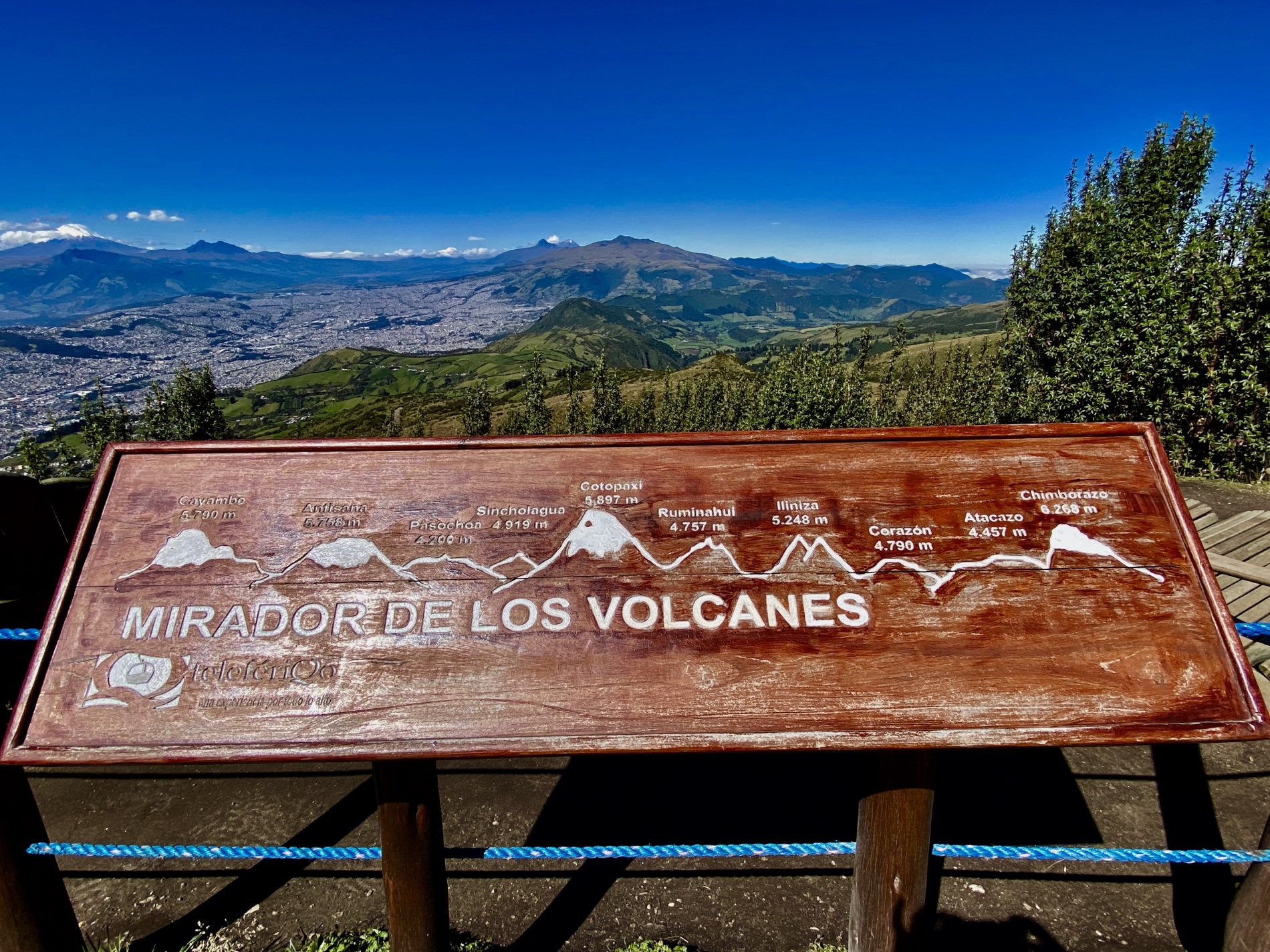
Friday, July 29: Freddy texted us early in the morning, our last day in Quito: “Hola Cathy buen día. Hoy es gran día para ir al teleferico. Esta despejado.” (Hello Cathy, good day. Today is a great day to go to the teleferico. It is clear.) We had already awoken and seen the sun and the blue skies so we got up and going and headed straight to the TelefériQo. From the top, we could see clearly the views from Rucu Pichincha. We saw all the volcanoes including Cotopaxi which we’d visit near the end of our trip (& go horseback riding) and Chimborozo, where we planned to ride bikes down the volcano. It was a stunning day and I was thrilled we got to see the views on a clear day.
Mirador de Los Volcanes
What an amazing morning. Sunshine, a cool breeze, a few clouds, the high grassland (páramo), the views of Quito and the volcanoes. I couldn’t have wished for a better last day in Quito.
As our hike from the TelefériQo was uphill at such a high altitude, it was tough to catch my breath. I took a lot of breaks. Also, my lower back had been killing me for several days and I had no idea why. I felt like I was 100 years old! Still it was worth every bit of pain I felt.
Mike climbed higher than I did; meanwhile I laid on the grass and a domesticated Andean condor came pecking in the grass around my head. He had no fear at all. You could hike to the summit of Rucu Pichincha (4680m), about a 3-hour hike for fit walkers, but we stopped well short of that.
Going up the TeleferiQo
views of Quito from Rucu Pichincha
views of Quito from Rucu Pichincha
Rucu Pichincha
Cotopaxi is behind Mike and me
views of Quito from Rucu Pichincha
views of Quito from Rucu Pichincha
views of Quito from Rucu Pichincha
Rucu Pichincha
Rucu Pichincha
Rucu Pichincha
swinging on Rucu Pichincha
swinging on Rucu Pichincha
Rucu Pichincha
Rucu Pichincha
Rucu Pichincha
Rucu Pichincha
a domesticated Andean condor
a domesticated Andean condor
Rucu Pichincha
Rucu Pichincha
Rucu Pichincha
Dinner at La Plazuela
We were exhausted so we went back to the apartment to relax for the rest of the afternoon. Then we walked to La Floresta to look for La Plazuela. No one at all was in the restaurant but the woman there was very friendly. We ordered two tinto veranos (they were huge!) and a Del Huerte Pizza. To top it off, we had a Torta de chocolate accompanied by ice cream (helado). We took an Uber back to the apartment and packed up most of our stuff for our early morning flight to Cuenca.
Mike with his tinto verano in La Plazuela
me and my tinto verano
Del Huerto Pizza
La Plazuela
Steps: 12,632: Miles: 5.34.
Saturday, July 30: Freddy took us to the Quito airport on Saturday morning at 7 a.m. for our LATAM Airlines flight at 8:59 a.m. to Cuenca. We had enjoyed Quito but we were excited to get on to the next stage of our trip.
Below is a video of our days in Quito. All photos included here are different from the ones in this post, and there are a few video clips as well.
Stay tuned for more on our fabulous trip to Ecuador.
We took a road trip to South Florida in March 2022. Our itinerary included Miami, Everglades National Park, the Florida Keys, and Fort Lauderdale. On our way back home, at the northeast corner of Florida, we spent two nights in St. Augustine. This post, part two, includes Everglades National Park & The Keys. Part three will include Fort Lauderdale and St. Augustine. The first part of our trip, in Miami, can be found here: a florida road trip {part one}: miami.
We hiked the Anhinga Trail and the Gumbo Limbo Trail at Everglades National Park, and then took the Flamingo Adventures Boat ride where we saw American crocodiles and manatees. We strolled amidst tropical hardwood hammocks, mahogany trees, sabal palms, cypresses and mangroves. We ate a delicious and lively dinner at Yardie Spice, a Jamaican restaurant in Homestead, with Jamaican owner J.P. hosting. We pedaled for 15 miles at Shark Valley Visitor Center and then sped over the river of grass in an air boat at Gator Park. We kayaked in a tandem in Big Cypress National Preserve where we communed with alligators and birds of all feathers and ended up bickering as we got tangled up in the mangrove trees. We visited two state parks in the Florida Keys, the nicest being Bahia Honda State Park, and shopped, strolled, nibbled and imbibed in Key West all the way to the Southernmost Point in the Continental U.S., which is 90 miles from Cuba and 150 miles from Miami. We enjoyed a Hoochie Mama Mojito and key lime pie at Paradise Restaurant in Key West as a rooster strutted his stuff near our table. Then we lounged by the pool at our hotel and waded in the seaweed-infested surf at Sombrero Beach in Marathon.
I recommend watching on YouTube for the best experience.
Our top ten things to do in the Everglades and the Florida Keys were:
10) Sombrero Beach in Marathon (Keys)
9) Big Cypress Bend Boardwalk (Big Cypress National Preserve)
8) The Anhinga Trail and the Gumbo Limbo Trail at the Ernest F. Coe Visitor Center (Everglades National Park)
7) Flamingo Adventures Boat Ride (Everglades)
6) Bahia Honda State Park (Keys)
5) Dinner (twice) at the Jamaican Yardie Spice in Homestead
4) Bicycling 15 miles at Shark Valley (Everglades)
3) Kayaking in Big Cypress National Preserve with Shurr Adventures Kayaking & Eco Tours
2) Key West
1) Airboat ride through the River of Grass with our hyperbolic guide at Gator Park
our Florida road trip
Everglades National Park & Florida Keys
Thank you for watching! I invite you to subscribe to my YouTube channel.
We explored Michigan as part of our Great Lakes RoadTrip in May-June of 2021. Our explorations included Minnesota, Wisconsin and Michigan. This video covers Michigan’s lower peninsula, affectionately referred to as “the Mitten” (see map below).
The Michigan Mitten is all about eclectic folksy inns; tunnels of trees; expansive sand dunes; famous authors like Hemingway, Bruce Catton, and Jim Harrison; lighthouses; weathered fish shanties; cherry orchards and grape vineyards; megachurches and the American Taliban; presidential museums; Henry Ford and the automobile; the University of Michigan in Ann Arbor; and obscure battlefields.
After crossing the Mackinac Bridge over the Straits of Mackinac, we: cruised through the Tunnel of Trees to Petoskey; enjoyed the thatch houses at Charlevoix; hiked the Cottonwood Trail at Sleeping Bear Dunes National Lakeshore; enjoyed a lovely dinner at The Cove in Leland, with views of weathered shanties on the Fishtown dock. We drove by Jim Harrison’s old home — writer’s cottage and all, and then cruised through cherry orchards and wineries up the slim Old Mission Peninsula, where we found another lighthouse. We came face-to-face with the DeVos evangelical mission in Holland, wandered the grounds of the Gerald R. Ford Presidential Museum (which was sadly closed due to COVID), and endured a bad experience with our Airbnb in Detroit, which turned out to be in the derelict Hamtramck neighborhood, and lost most of our money. We wandered through Ann Arbor and watched In the Heights at the Michigan Theater. We learned about the history of cars and American innovation at The Henry Ford in Dearborn. After dropping Mike at the Detroit airport, I went on to learn about an obscure battle in the War of 1812 at the River Raisin National Battlefield Park: “Remember the Raisin!”
Our top ten experiences in Michigan’s Lower Peninsula were:
10) Cross Village & the Tunnel of Trees
9) Grand Haven and the Tri-Cities Historical Museum
8) Grand Rapids and the grounds of the Gerald R. Ford Presidential Museum
7) Petoskey
6) Charlevoix
5) Dearborn: The Henry Ford Museum & Greenfield Village
4) Ann Arbor: the charming town & the University of Michigan
3) The Old Mission Peninsula: cherry orchards, wineries, & lighthouses
2) Sleeping Bear Dunes National Lakeshore
1) Leelanau Peninsula: Leland, Fishtown, and Jim Harrison’s old home
We explored Wisconsin as part of our Great Lakes RoadTrip in May-June of 2021. Our explorations included Minnesota, Wisconsin and Michigan.
Wisconsin is all about scenic Rt. 13, the charming town of Bayfield, the murals of Ashland, lakes, freshwater fishing, boating, sandstone formations, maritime history, dairy cows, cheese & cheese curds, beer, bratwurst and fish boils. It is about walks along the Mississippi and the Milwaukee Rivers and Lake Superior. It is about the University of Wisconsin in Madison, locks and dams, charming villages, grottoes and smoked fish.
We cruised through Apostle Islands National Lakeshore on a cold and blustery day, searched for waterfalls at Copper Falls State Park, climbed inside of a giant sturgeon at the Freshwater Fishing Hall of Fame, stopped for a beer flight at Jacob Leinenkugel Brewing Co. in Chippewa Falls, and paid our respects to veterans at the High Ground on Memorial Day, topped off by an old-fashioned Chinese meal at Shaw Lee in Wisconsin Rapids. We strolled through Witches Gulch and watched a dog jump over an abyss at Stand Rock in Wisconsin Dells. We climbed the steep boulder-strewn trail at Devil’s Lake State Park to the Devil’s Doorway. We enjoyed a Bodega Bowl in the shadow of the Wisconsin State Capitol in Madison, and wandered around the stunning University of Wisconsin campus. We meandered down State Street and enjoyed dumplings at Chen’s Noodles & Dumplings. We munched on cheese curds and beer at Lakefront Brewery in Milwaukee. We wandered through the “Streets of Old Milwaukee” and the European Village and learned about Nelson Mandela at the Milwaukee Public Museum. We glimpsed all-things-beer including Miller Brewing and the Pabst Mansion, then met “the Fonz” on the Riverwalk. We explored the Public Market and the Historic Third Ward. We learned about maritime history in Sturgeon Bay and walked along limestone bedrock fronting Lake Michigan at Cave Point County Park. We witnessed a conflagration and ate whitefish at a fish boil at Pelletier’s in Fish Creek. We soaked up a stunning sunset at Sunset Beach at Fish Creek. And finally, we donned cheeseheads and did the “Lambeau Leap” at Lambeau Field in Green Bay.
Our top ten experiences in Wisconsin were:
10) Green Bay – Lambeau Field
9) Dickeyville Grotto
8) Hayward Fresh Water Fishing Hall of Fame & Museum
7) Jacob Leinenkugel Brewing Co. in Chippewa Falls
6) Wisconsin Dells
5) Devil’s Lake State Park: The Balanced Rock Trail
4) Milwaukee : Milwaukee Public Museum, Riverwalk, the Historic Third Ward & the Milwaukee Public Market
3) Madison: University of Wisconsin, State Street, & the Wisconsin State Capitol
2) Apostle Island National Lakeshore: Apostle Islands Cruises (The Grand Tour)
1) Door County: Maritime Museum in Sturgeon Bay, Fish Creek & Pelletier’s Nightly Fish Boil, & Cave Point County Park
We explored Minnesota as part of our Great Lakes RoadTrip in May-June of 2021. Our explorations included Minnesota, Wisconsin and Michigan.
Southern Minnesota was all about marine art, the birthplace of waterskiing, and the world’s largest 16-foot-tall work boot. It was about SPAM, the Jolly Green Giant, horizontal landscapes of endless farmland, Blue Mounds, Pipestone quarries and the Indian pipes made from them, Sioux quartzite, and invisible petroglyphs. It was a land of German towns, waterfalls, and the Mississippi River. It was also about reconciliation in Mankato and a bank robbery by the notorious James-Younger gang in Northfield.
In Minneapolis, we strolled through sculpture gardens, across old stone bridges, and under signs for Gold Medal Flour and Pillsbury’s Best Flour. We cruised through the University of Minnesota, bicycled around lakes in Minneapolis, and sang to musical murals. We browsed the Minnesota History Museum and learned about iron ore, lumber, the collapse of Interstate 35 in 2007, Minnesota blizzards & tornadoes, and Sinclair Lewis. We paid our respects to George Floyd, Prince and Bob Dylan, peeked into the On Being studio, and met Charlie Brown and the gang in St. Paul.
Here are my top ten favorites of southern Minnesota (The Twin Cities & south):
10) George Floyd Square in Minneapolis
9) Minnesota Marine Art Museum in Winona
8) Pipestone National Monument
7) The charming town of Northfield and the Northfield Historical Society Museum
6) The SPAM Museum in Austin
5) Minneapolis Sculpture Garden
4) Blue Mounds State Park near Luverne
3) Bikeride around Minneapolis lakes
2) Minnesota History Museum in St. Paul
1) Murals of Minneapolis (especially Prince, Bob Dylan & the Music Wall)
Here’s the map of our route in 2021. I’ll cover the northern part of Minnesota in another video.
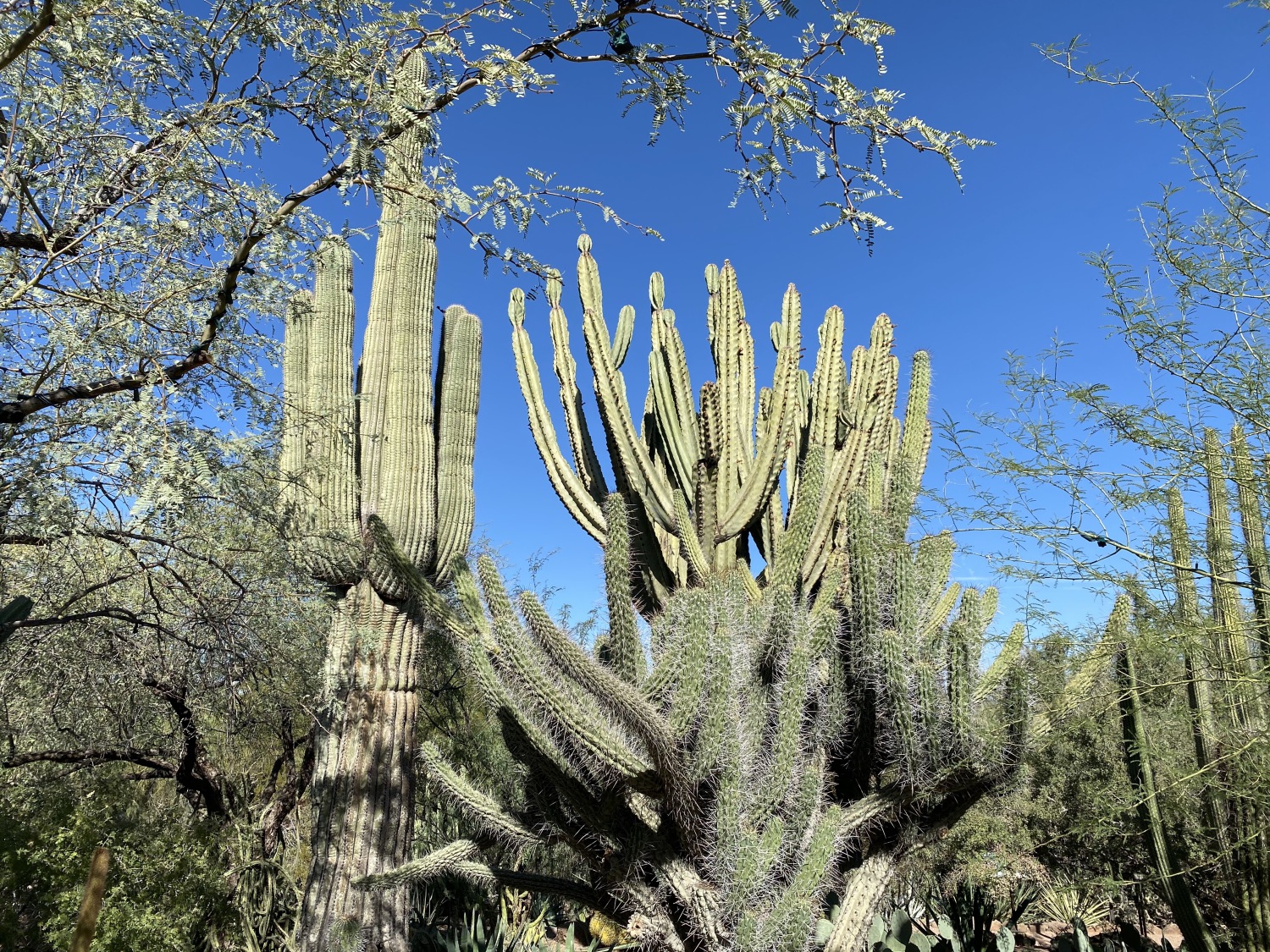
In November of 2020, as part of our Canyon & Cactus Road Trip, I: crossed into Arizona and fell in love with chartreuse leaves in Oak Canyon on the way to Sedona; drove south to Montezuma Castle National Monument and Montezuma Well; hiked the Eagles Nest Loop at Red Rock State Park in Sedona; sat quietly under Buddhist prayer flags at Amitabha Stupa & Peace Park in Sedona, turned the prayer wheel, and walked 3x clockwise offering lots of prayers; got a wonderful 90-minute hot stone massage at Namti Spa; spent Election Day nearly getting struck by lightning at Tuzigoot National Monument; spent a day in Phoenix at the Phoenix Art Museum and the Heard Museum; visited Casa Grande Ruins National Monument; met a huge variety of cacti at Desert Botanical Garden and wandered through Old Town Scottsdale; hiked through Saguaro National Park (West and East); avoided rattlesnakes on a climb to see petrogylphs by the Hohokam people at the Signal Hill Trail; wandered through the Arizona-Sonora Desert Museum, finding javelinas and more cacti: hedgehog, barrel, staghorn, teddy bear cholla, catclaw, dwarf organ pipe cactus, Woolly Jacket prickly pear, Cowboy Whiskers Prickly Pear and ocotillo. Followed a van in Tucson with a bumper sticker: “BIDEN 2020: He won’t inject you with bleach.” Went to Tumacácori National Historical Park and Tubac, where I bought some colorful cactus and coyote yard ornaments; lit a candle for our country and my children at Mission San Xavier del Bac; gobbled down Indian fry bread at Cafe Santa Rosa in Tucson; wandered through the charming but scruffy town of Bisbee, a former copper mining town; missed the shootout at the OK Corral in Tombstone; took a fabulous (but freezing) hike at the sky island of Chiricahua National Monument; got a flat tire driving on a dirt road to Fort Bowie, but didn’t even visit there after all that.
Here are my top ten favorites in southern Arizona, with a couple of odds & ends thrown in:
11) Odds & Ends: Old Town Scottsdale, ASU Gammage Auditorium in Phoenix, Casa Ruins National Monument, Tumacácori National Historical Park, & Bisbee
10) Pipe Spring National Monument (northern Arizona)
9) Montezuma Castle & Montezuma Well
8) Tombstone
7) Tuzigoot National Monument
6) Arizona Sonora Desert Museum in Tucson
5) Phoenix: (a) Phoenix Art Museum, (b) Heard Museum, (c) Desert Botanical Garden
4) City of Tucson & Saguaro National Park West & East
3) Tubac & Mission San Xavier del Bac
2) Sedona, Red Rock State Park, & Amitabha Stupa
1) Chiricahua National Monument
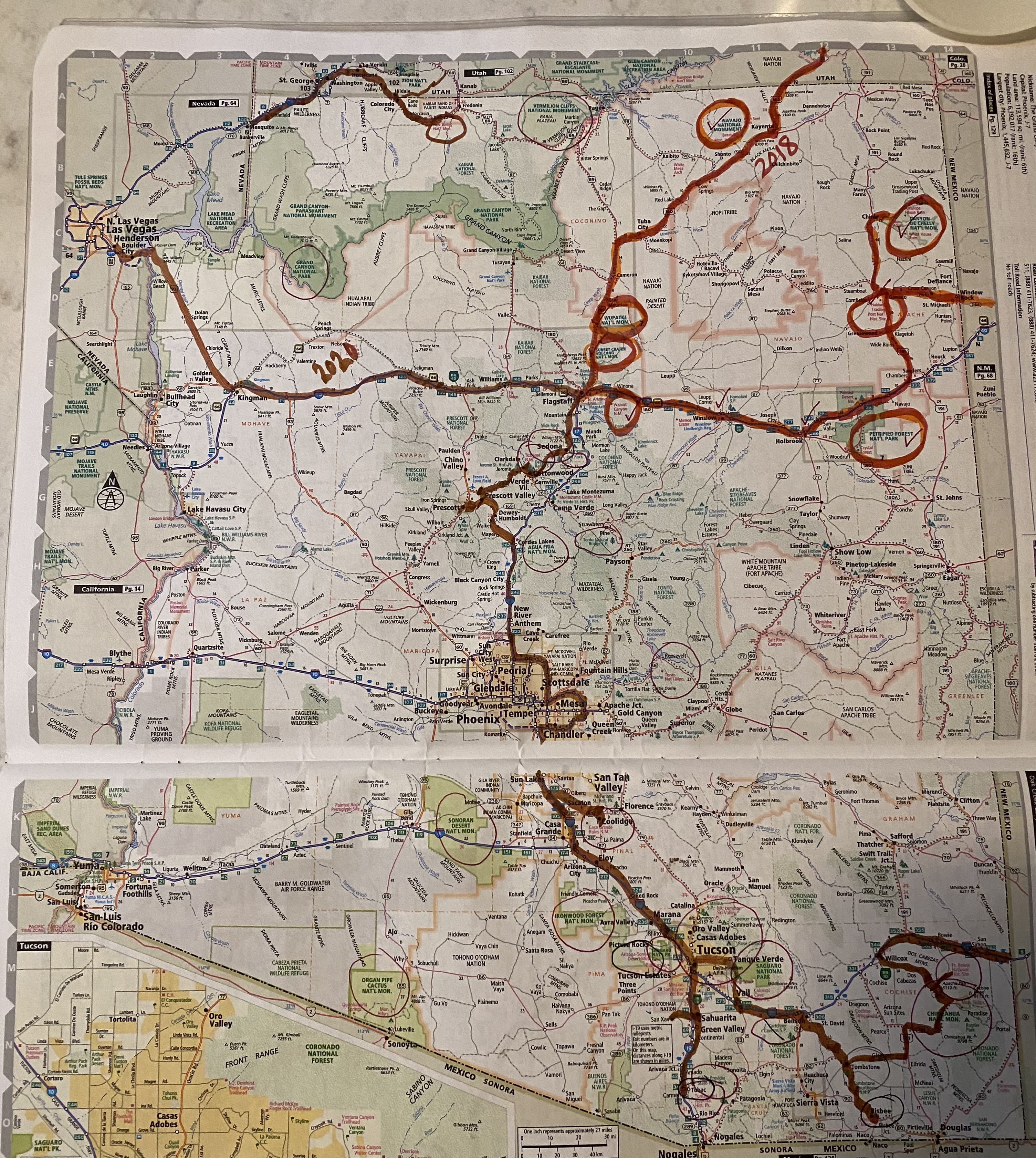
Here’s the map of our route in 2020. The red shows our route in 2018. Pipestone National Monument is in the north central part of the state, where we dipped down from Utah for a short visit and then returned to Utah.
As part of our “Canyon & Cactus Road Trip” in October-November of 2020, we spent two weeks exploring the National and State Parks in southwest Utah. This “video/slideshow” encapsulates our two week trip through this fabulous state.
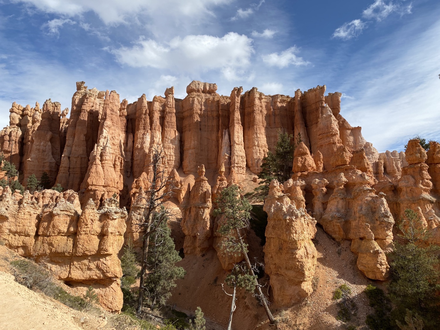
In southwest Utah, we: met with our son and his girlfriend in Green River. Hiked the narrow slot canyon, Little Wild Horse Canyon, in the San Rafael Swell. Wandered amidst goblin-shaped rock formations at Goblin Valley State Park after picnicking at a red picnic table. Hiked throughout Capitol Reef National Park and learned about the Mormon community and the orchards there. Stopped for astounding scenic overlooks at Grand Staircase Escalante National Monument. Strolled among towering sandstone chimneys at Kodachrome Basin State Park. Encountered more bulbous columns called hoodoos at Bryce Canyon National Park on the Queen’s Garden and Navajo Loop Trail. Celebrated my 65th birthday, officially becoming a senior citizen in Bryce. Climbed ever upward in snow and 4°F temps to Cedar Breaks National Monument, where my fingers nearly froze off in just a few minutes of being outdoors. Hiked the Scout Lookout Trail at Zion National Park, where Ariana was the only one of us to make it to the top of Angel’s Landing. Hiked the Kayenta Trail and the Emerald Pool Trails at Zion, where we had fabulous views of the Virgin River. Decked myself out in neoprene socks, water shoes and waterproof pants to hike and wade up the Narrows at Zion. Observed changes in plant species from wildflowers and willows on the canyon floor to cacti and pinyon pines at higher elevations. Enjoyed a fabulous bacon-wrapped meatloaf Napoleon at Switchback Grille in Springdale, and said our goodbyes to Alex and Ariana as they headed back to Denver the next morning. Squeezed in a couple more hikes in Zion and then drove to Coral Pink Sand Dunes State Park. Enjoyed an excellent belated birthday dinner in St. George at the Painted Pony Restaurant. Hiked the Petrified Dunes Trail at Snow Canyon State Park.
Our top 10 sights to see in southwest Utah were (in descending order):
10) Cedar Breaks National Monument & Cedar City
9) Coral Pink Sand Dunes State Park
8) Dixie National Forest & Grand Staircase Escalante National Monument
7) Goblin Valley State Park
6) Snow Canyon State Park
5) Kodachrome Basin State Park
4) Capitol Reef National Park
3) Little Wild Horse Canyon in San Rafael Swell
2) Bryce Canyon National Park
1) Zion National Park & Springdale
We explored southeast Utah in 2018; I’ll make another video about that trip later.
Below is the map showing our route through southwest Utah.
Happy belated New Year! I’ve enjoyed having my year off from blogging but I’m ready to open it up again for 2022. I didn’t accomplish anything I set out to do; instead I focused on restoring my health and trying to make the most of life while struggling through another year of pandemic.
I don’t intend to write much this year. Instead, I want to experiment with making videos of some of my travels, focusing on travels since the pandemic began and maybe some of my past travels. If I’m able to travel any this year, I’ll try to make some for those travels as well.
There’s one big caveat. I’ve never made a video before; I’ll have to learn as I go along. Since I don’t actually have much video footage, they’ll be mostly slideshow videos (with photos only) set to music. I’ll try to take more videos while traveling in the future. The only writing I’ll do is a list of my “Top 10” for a destination, and maybe a paragraph of highlights. That will be the extent of it.
Mostly, I just want to have fun and challenge myself to learn something new.
Here are some pages from my 2022 bullet journal where I plot out my year as I’d like it to be. Who knows if any of it will happen, especially with the pandemic still tearing its way through the world. We can always hope.
my overall goals
Word of the year, as yet unknown, & some goals
my travel dreams for 2022
January cover page
my reading goals
Happy New Year! I wish all of you good health and much happiness in 2022.
My path less traveled. Rediscovering self after surviving the abuse that almost sunk me. Goal of strengthening and thriving on my adult legs. 👣🙏🏻 #recovery #forgiveness
This blog is for those who wish to be creative, authors, people in the healing professions, business people, freelancers, journalists, poets, and teachers. You will learn about how to write well, and about getting published. Both beginning and experienced writers will profit from this blog and gain new creative perspectives. Become inspired from global writers, and find healing through the written word.
Explore, discover and experience the world through Meery's Eye. Off the beat budget traveler. Explore places, cultural and heritage. Sustainable trotter.
shareable tales of Meery is Meeryable


You must be logged in to post a comment.