Monday, October 3, 2022: This morning we checked out of our Airbnb in Saint John and headed for The Hopewell Rocks.
The Hopewell Rocks, also called the Flowerpot Rocks, or simply The Rocks, are rock formations known as sea stacks caused by tidal erosion. They are scattered on the shores of the upper reaches of the Bay of Fundy at the Hopewell Rocks Provincial Park in New Brunswick, Canada. Due to the extreme tidal range of the Bay of Fundy, the base of the formations are covered in water twice a day. It is possible to view the formations from ground level at low tide, which is what we did.
The Hopewell Rocks formations consist of red-brown sedimentary sandstone and minor mudstone rock. They stand 40-70 feet tall. After the retreat of the glaciers in the last Ice Age, surface water filtering through cracks in the cliffs eroded and separated the formations from the rest of the cliff face. Meanwhile, advancing and retreating tides and the associated waves have eroded the base of the rocks at a faster rate than the tops, resulting in their unusual shapes.
We went at low tide to explore the ocean floor around the rocks. We were lucky to have a beautiful day.
It was about a 15-minute walk from the visitor center to the rocks. As we walked, I started doing an exaggerated march, being my silly self. I was wearing my new fisherman hat. Mike said, “Oh, there goes Chairman Mao marching away!” We laughed so hard we were in convulsions. That hat is truly a Chairman Mao hat.:-)
High tide today was at 18:44 and low tide was at 12:43. We arrived at 11:43, and wandered along the coastal floor from one end to the other. The rock formations looked like Clydesdale hooves with all the seaweed clinging to the bases. Our feet got quite muddy traipsing around but there was a fountain at the top to clean them off.
Hopewell Rocks
Hopewell Rocks
Hopewell Rocks
Hopewell Rocks as the tide is going out
Hopewell Rocks
Hopewell Rocks
Hopewell Rocks
Hopewell Rocks
Hopewell Rocks
Hopewell Rocks
Hopewell Rocks
Chairman Mao at Hopewell Rocks
Mike at Hopewell Rocks
Hopewell Rocks
Hopewell Rocks
Hopewell Rocks
Hopewell Rocks
Hopewell Rocks
Hopewell Rocks
Hopewell Rocks
Hopewell Rocks
Hopewell Rocks
Hopewell Rocks
Hopewell Rocks
Hopewell Rocks
Hopewell Rocks
Seaweed at Hopewell Rocks
me with seaweed piles
Hopewell Rocks
Hopewell Rocks
Hopewell Rocks
Hopewell Rocks
Hopewell Rocks
Hopewell Rocks
Hopewell Rocks
Hopewell Rocks
Hopewell Rocks
Hopewell Rocks
Mike at Hopewell Rocks
me at Hopewell Rocks
Hopewell Rocks
Back up near the Visitor Center we had a view of the mudflats, coastline and the Bay of Fundy itself at Daniels Flats, named for one of the area’s early settlers. The bay is about 2.5 miles wide at this point. Salt marshes form a green band around the Bay of Fundy.
Daniels Flats
Daniels Flats
Because the Bay of Fundy is funnel-shaped (wide/deep at one end and narrow/shallow at the other) tides are pushed increasingly higher as they move up the bay.The length of the bay also plays a factor by causing a natural sloshing effect called resonance. This sloshing amplifies the effect of the funnel.
Among the highest in the world, the tides reach up to 14 meters (46 feet) at Hopewell Cape and 17 meters (56 feet) in the upper reaches of the bay. Not only does the tide rise 46 feet (14 meters) vertically, it also recedes almost two football fields horizontally. In fact, 160 billion tons of water move in and out of the bay every 25 hours. Powered by the gravitational pull of the moon and sun, Fundy’s tides are among the highest in the world and vary daily with the changing positions of these celestial bodies.
The name Fundy is thought to be an English translation for the French word “fendu” meaning “split.” The bay has been navigated by western European fishermen since the 16th century.
Bay of Fundy
formation of the flower pot rocks
Bay of Fundy
I posed for a picture with my fisherman hat in the tiny S. S. Hopewell. So goofy. 🙂 Mike has endless names for me in my hat. Here, I’m Popeye the Sailor Man. 🙂
me in the S.S. Hopewell
We left Hopewell Rocks and went by Cape Enrage. The 140-year-old lighthouse, which is still working, is perched on the end of the cape’s rocky promontory. Here, tides rise 16 vertical meters (53 feet). We stopped here but it was closed and locked so we couldn’t walk the beach trails.
Cape Enrage
Cape Enrage
Cape Enrage
On the way, we got out to wander a bit on a cairn-dotted rocky beach.
cairn-dotted rocky beach
cairn-dotted rocky beach
cairn-dotted rocky beach
marshlands near Cape Enrage
Back at Fundy National Park, we took a short (boring) hike to Point Wolfe Beach after checking out the cute red covered bridge.
The Point Wolfe River was once the center of a lumber operation. In the early 1800s, the lumber industry was booming on New Brunswick and mills sprung up on most rivers along the Bay. The Point Wolfe Mill was opened in 1826 and continued off and on for almost 100 years.
covered bridge in Fundy National Park
trail to Point Wolfe Beach
trail to Point Wolfe Beach
little pretties along the trail
Point Wolfe Beach
Point Wolfe Beach
We finally headed to Alma where we would stay the night. The small seaside village services Fundy National Park with restaurants and motels.
We showered and changed and wandered around town looking for a place to eat. I had it in my mind I wanted lobster. We found a lineup of colorful Adirondack chairs and boats tied to the wharf which made fetching reflections in the water.
Alma Lobster Shop beckoned. Mike had a lobster roll and chowder. I had a Lazy Lobster Dinner: Shucked lobster meat, cole slaw, drawn butter and roll. We sat on the open air porch, where annoying flies buzzed all around us. We bought two mugs and an Alma lobster shop onesie for the real-life Alma that Mike’s best friend’s son is trying to adopt.
Alma
Alma
Alma
Alma
Alma Lobster Shop
Alma Lobster Shop
Alma Lobster Shop
Alma Lobster Shop
Alma Lobster Shop
As we walked back to our tiny but cozy Airbnb, we saw fishing paraphernalia, colorful coils of rope and lobster pots.
We settled into our cozy Airbnb and watched the last episodes of Virgin River and read.
Alma fishing yard
colorful ropes
our tiny but cozy Airbnb
Steps: 16,779; Miles 7.09. Drove 160 miles.
Tuesday, October 4: This morning we left Alma and headed to Prince Edward Island to visit my friend Lisa. On the way, we returned to Hopewell Rocks. We were hoping to see the rocks at high tide, at which time all you can see are the tops of the rocks covered with vegetation and appearing as tiny islands. Alas, we arrived too late for high tide. We got there at 9:58 a.m., and high tide had been around 7:50 a.m., so we were two hours late. The water was definitely higher than when we were there yesterday, but it was low enough that we could have walked all the way to the beach at the far end.
The time span between low and high tide is 6 hours and 13 minutes. People have the chance to walk on the ocean’s floor from 3 hours before low tide until 3 hours after.
Today’s hours of operation in the park were 9:00 to 17:00, so there was no way we would have seen the morning’s high tide anyway.
We enjoyed some views of the Flower Pots nearest the stairs but they weren’t covered at all by water while we were there from 10:00 a.m. until 10:20 a.m.
Hopewell Rocks on Tuesday morning
the Tides on Tuesday morning
Hopewell Rocks as the tide is going out
Hopewell Rocks as the tide is going out
We took off, heading for Prince Edward Island. We made a stop in Moncton at Café Archibald, where we had coffees and an egg, bacon and cheese English muffin. The cafe was cute and the staff was busily preparing lunches for take-out.
We left after a bit and drove down Moncton’s main street. It was a charming town. People apparently spoke both French and English there. I was sad we didn’t have time to explore more.
Still in New Brunswick, we stopped at Cape Jourimain to take pictures of the Confederation Bridge leading to Prince Edward Island. It is a box-girder bridge carrying the Trans-Canada Highway across the Abegweit Passage of the Northumberland Strait, linking the province of Prince Edward Island with New Brunswick on the mainland. Opened May 31, 1997, the 12.9km (8.0mi) bridge is Canada’s longest bridge and the world’s largest bridge over ice-covered water.
Tolls only apply when leaving Prince Edward Island (traveling westbound). Toll rates since January 2022 are $50.25 for a two-axle auto. Motorcycles pay $20. Pedestrians and cyclists are not permitted to cross the bridge, but a shuttle service is available.
Cape Jourimain is an area comprising two islands and a section of mainland along the southwestern shore of the Northumberland Strait. The two islands, Jourimain and Trenholm, have been connected to the mainland since 1966 by an artificial causeway. It is host to the western end of the Confederation Bridge. In 1980, the two islands, including a section of mainland, were designated as a National Wildlife Area.
There were trails that looked enticing but we didn’t take them because we were due to be at Lisa’s house by 3:00-4:00.
We saw a lighthouse, the Cape Jourimain Lighthouse, built in 1870 after nearly 30 years of petitions. The 15.5m lighthouse was built to help sailors navigate the narrow strait. The lighthouse operated until 1997 when the Cape Tormentine Ferry service was decommissioned as a result of the opening of the Confederation Bridge.
Cape Jourimain
me at Cape Jourimain with the Confederation Bridge behind me
The Confederation Bridge from Cape Jourimain
The Confederation Bridge from Cape Jourimain
Cape Jourimain
Cape Jourimain
Here is a short video of our time at Hopewell Rocks and the rest of New Brunswick.
We crossed the Confederation Bridge to Prince Edward Island.
We spent four nights in Saint John, New Brunswick, from which we visited Fundy National Park, the Bay of Fundy, Ministers Island, and St. Andrews by-the-Sea, as well as exploring the city of Saint John.
Friday, September 30: We got a relatively early start today since we had a longish drive to Fundy National Park. The park preserves unique wilderness on the shores of the Bay of Fundy. It has wilderness areas, as well as beaches, rocky headlands, sea caves and inlets, wildlife and stunning vistas.
This 206-square-km (80 sq. miles) park was New Brunswick’s first national park and serves as a microcosm of New Brunswick’s inland and coastal climates. It has been designated as a Dark Sky Preserve by the Royal Astronomical Society of Canada.
Among the most scenic of the park’s 100km of biking and hiking trails is Laverty Falls, a 2 1/2 km (1 1/2 mi) trail that descends through hardwood forests to Laverty Waterfall.
We made a quick stop at Wolfe Lake to see what maps we could get from the Visitor Center. The ranger told us she thought the dirt access road to the Laverty Falls Trail was closed due to fallen trees felled by Hurricane Fiona.
Hoping she was wrong, we drove there anywaw to find the crews had cleared all the trees and we were able to drive up the very long road. When we got to the parking lot, we were the only ones there. It was quite cold, so I was all bundled up in layers, a fuzzy hat and gloves, but because the trail was a descent followed by an ascent, I had taken off most layers by the time we returned to the top.
I prefer to hike with wide open vistas, but the Laverty Falls hike was all in a forest. The forest seemed rather magical, however, with its golden ferns, spaced-out pine trees, moss-covered glades, and dappled light. Likely because of Fiona, there were downed trees and streams flowing down the middle of the path, so it made for some creative rock- and root-hopping. We had the trail almost to ourselves.
We ate bread and cheese on rocks near the beautiful Laverty Waterfall and then made our way back to the top.
Laverty Falls hike
Laverty Falls hike
Laverty Falls hike
Laverty Falls hike
Laverty Falls hike
Laverty Falls hike
Laverty Falls hike
Laverty Falls hike
Laverty Falls hike
a squirrel at Laverty Falls
Laverty Falls hike
Laverty Falls hike
Laverty Falls hike
Laverty Falls hike
Laverty Falls hike
Laverty Falls hike
Laverty Falls hike
Laverty Falls
Laverty Falls
Laverty Falls
Laverty Falls
Laverty Falls hike
Laverty Falls hike
Laverty Falls hike
Laverty Falls hike
Laverty Falls hike
Mike on the Laverty Falls hike
Laverty Falls hike
Me at the end of the hike
After the hike, we drove to the eastern end of Fundy National Park, the bayside, for a viewpoint or two and checked out the small town of Alma where we would stay for one night on our way to Prince Edward Island. To get back to Saint John, we drove through the park again.
view of the Bay of Fundy
Alma
view of the bay from Alma
boardwalk at Alma
Alma marina
marina at Alma
entering back into the park
We had to stop to see the strange golf course at Fundy that Mike remembered playing as a 12- or 13-year-old when he visited with his parents. The tee for the first hole is at the top of a cliff.
The course, nestled in the Dickson Brook Valley, was designed by course architect Stanley Thompson. It has some tricky greens and some quite taxing elevations, but carts are available.
first tee at the Fundy National Park golf course
The New Brunswick side of the Upper Bay of Fundy was designated by UNESCO in 2007 as a World Biosphere Reserve celebrating the area’s unique ecosystems, landscapes and cultures. Biosphere Reserves aim to improve the relationship between people and their environment by promoting the conservation of biodiversity and fostering sustainable development. Fundy National Park is the heart of this Fundy Biosphere Reserve.
Some interesting facts we learned:
Today many agricultural lands are a result of dykes built by the Acadians in the 18th century.
Salt marshes form in sheltered areas of tidal mud flats. They are very productive nursery habitats for many species of the Bay and adjacent land.
The Acadian Forest is made up of 32 species of trees which form a rich ecosystem that is home to people and a multitude of plant and animal life.
Arriving along the Fundy shores in late July from the Canadian Arctic, thousands of shorebirds fatten up on tiny mud shrimp in preparation for a non-stop flight to South America.
The Fisherman’s Clock is always changing. Fishing boats can only leave or dock at the wharf when the height of the tide permits. The night time could be morning, noon, or night!
Saint John
After our trip to Fundy National Park, we went out to dinner at Thandi (“East Meets West”) in Saint John. It’s an Asian fusion place but we had Indian food. I enjoyed Korma with shrimp: a mild creamy sauce combined with a mixture of cashews. Mike had Dal Makhani, an Indian lentil delicacy in rich cream sauce with onions, tomatoes, ginger, garlic and spices.
Mike and I must have been spending too much time together because I got quite annoyed with him after some comments he made about a book I’ve been reading (In the Field by Claire Tacon). I said I couldn’t wait to finish my book. He said, “Why, is it a mystery?” As if a person should only want to find out the ending to a mystery but not any other kind of book. I rarely read mysteries and I’d already told him a lot about this book, which is literary fiction and is set in Nova Scotia. Don’t we want to find out the ending to every genre of book we read? As an English major and an avid reader, I get impatient with his occasional confusion about genres of books and points of view. He said I was being condescending (which I was) and I said he was being condescending (which he was).
On top of that, the waiter kept addressing Mike directly and acting as if I didn’t exist. “Sir, what would you like?” “Sir, can I get you anything else?” It was so patriarchal and annoying. I said, “There are two of us here. And yes, I’m fine, thank you!” I don’t think the guy knew how to speak to women.
Thandi
Thandi
Korma with shrimp
Dal Makhani
Finally, we both relaxed and decided to put it all behind us. We managed to get out of there without strangling each other and the waiter.
We meandered back to our Airbnb, stopping to admire the 1880 Trinity Anglican Church, a Gothic Revival stone church. It was designated a local Historic Place for its architecture and for being the first established congregation in the city.
The port town of Saint John is a much smaller and more industrial city than Halifax. We saw one of two big cruise ships pulling out of port, a beautiful sunset over the harbor, and some cute shops along the streets.
sunset at Saint John waterfront
Trinity Anglican Church
Mike carrying our leftovers
Saint John, New Brunswick
cute shop in Saint John
me in our meanderings through Saint John
another cute shop in Saint John
Back in our Airbnb, we got cozy and watched several more episodes of Virgin River and then cuddled up for the night.
Steps: 19,119; Miles: 8.09. Drove 176.3 miles.
Saturday, October 1: This morning Mike worked out on the exercise bike on our Airbnb apartment while I had a leisurely morning and a hot bath. Then we went out to explore and learn what we could about the city of Saint John.
Mike rides the exercise bike in our Airbnb
Our Airbnb is on the top floor
Natives of Saint John welcomed explorers Samuel de Champlain and Sieur de Monts when the Frenchmen landed here on St. John the Baptist Day in 1604. It was the first city to be incorporated in Canada in 1785. Nearly two centuries later, residents opened their rocky forested land to 3,000 British Loyalists fleeing the U.S. after the American Revolutionary War, and then an influx of Irish families, thousands who came after the Napoleonic Wars in 1815, and then later many thousands more during the Irish potato famine of 1845-1852.
Today cruise ships bring visitors (75 in 2018) that dock at its revitalized waterfront. Now the city has two cruise terminals.
Industry and the salt air combine to give Saint John a weather-beaten quality, but the town also has restored 19th-century wooden and red brick homes as well as modern office buildings, hotels and shops.
Reversing Falls Rapids
We went first thing to see the famous Reversing Falls Rapids in Saint John. The Reversing Falls gorge is the sole drainage outflow for 55,000 square kilometers of land mass in both New Brunswick and the state of Maine.
The strong Fundy tides rise higher than the water level of the Saint John River, so twice each day at the Reversing Falls Rapids, the tide water from the bay pushes the river some 90km (56mi) back upstream and the rapids appear to reverse themselves. We visited first at low tide, around 11:00 a.m. where we saw the rapids of the river flowing toward the bay. At low tide, the full flow of the 724.5km (450mi) Saint John River rolls and swirls through the narrow gorge between Falls View Park and the Irving Pulp & Paper Mill.
We visited again at 4:00 p.m. to see the higher water levels and the rapids going upstream on the river. It is a fascinating phenomenon and we tried many different viewpoints. Sadly, marring the view is that unsightly pulp plant.
Slack tide only lasts for about 20 minutes and happens when the Bay of Fundy waters begin to rise and slow the river’s flow, eventually stopping the flow completely. During the time between these contrary events, the water’s surface rests placidly at slack tide, allowing vessels to come and go through the 150-meter-wide gorge in relative safety. This is the only time that sailboats and pleasure crafts can sail between the Bay of Fundy and the Saint John River.
The Reversing Falls Rapids phenomenon is only about 3,000 years old. The phenomenon is blamed on the Bay of Fundy, a dynamic marine ecosystem known for producing the world’s most extreme tides.
Reversing Falls Rapids
Reversing Falls Rapids
Reversing Falls Rapids
Reversing Falls Rapids
Reversing Falls Rapids
Reversing Falls Rapids
Reversing Falls Rapids
Besides viewing the Reversing Falls twice during the day, we wandered around the town, first stopping for coffee at Catapult Coffee (pumpkin spice latte!). One thing we wanted to do today was to visit the New Brunswick Museum, which supposedly covered the history, geology, and culture of New Brunswick. Sadly it was closed because of “the stress on the artifacts due to large numbers of visitors.” They were looking to relocate it to a larger space elsewhere. That left us with not much to do except eat, drink, shop and see the Reversing Rapids. I did however manage to buy two pairs of earrings and a bookmark at the New Brunswick Museum Gift Shop. 🙂
Catapult Coffee & Studio
Catapult Coffee & Studio
Catapult Coffee & Studio
Trinity Anglican Church
New Brunswick Museum
New Brunswick Museum
We wandered through the Saint John City Market (the oldest continuously operating farmer’s market in Canada, dating from 1876),with its offerings of mustards, honey, syrups, produce, boxes of La Croix sparking water, and take-out eateries (but no place to sit).
Saint John City Market
Saint John City Market
We ate plenty of greens at Marci’s Salads Reimagined, where I had a La Mixta salad and Mike a Sweet Root salad.
Of course I always manage to sniff out a clothing store. I discovered In Pursuit: The Uptown Boutique, where I tried on lots of clothes. Ever patient Mike rested in a “husband chair” while I perused the shop. I bought a black sweatshirt that says “EAST COAST” and a brown Fair Isle sweater. I could have bought more if Mike hadn’t been there!
Marci’s Salads Reimagined
Marci’s Salads Reimagined
Marci’s Salads Reimagined
alley behind Marci’s Salads Reimagined
Mike in his “husband chair” at In Pursuit: The Uptown Boutique
We found some cool murals in our wanderings, one with a giant colorful tortoise and another with an octopus.
Tortoise mural
ocotpus mural
marsh of dreams
Saint John doesn’t have much of a waterfront but plans are underway to re-imagine it. Currently they have a “Container Village” where the cruise ships dock. We wandered through the more than 60 colorful containers but the shops weren’t all that enticing. Calling something a “boutique” when it’s in a container is quite a stretch. Shops open were called Boatique, Beaver Tails, Cannabis NB, The Sugar Spider, and The Vagabond Studios. The village is designed to cater to music events and cruise passengers.
Container Village
Container Village
Container Village
Container Village
Container Village
Container Village
We wandered through the downtown and pretty neighborhoods back to our Airbnb.
downtown Saint John
neighborhoods of Saint John
neighborhoods of Saint John
We drove over to Reversing Falls Rapids at high tide, around 4:00 p.m. and saw the rapids going up the river.
Reversing Falls at high tide
We stayed in this evening and ate our Thandi leftovers and watched several back-to-back episodes of Virgin River.
Here’s a video of the water in action around the Bay of Fundy.
Sunday, October 2, 2022: This morning we drove to St. Andrews by-the-Sea in New Brunswick, almost to the U.S. border in Maine. But before we went into the town, we drove over a sand bar at low tide to Ministers Island.
Ministers Island
The Passamaquoddy people lived on this island, Qonasqamqi Monihkuk, for thousands of years. In 1790, Samuel Andrews, an Anglican minister and Loyalist, built a home here, hence the name. Around 1890, William Van Horne, visionary builder of the Canadian Pacific Railway, established his summer estate here.
The 490-acre Ministers Island stands several hundred meters offshore in New Brunswick’s Passamaquoddy Bay, immediately northeast of St. Andrews-by-the-Sea. It is a geographical oddity in that it is accessible at low tide only by the wide gravel bar suitable for vehicular travel.
It is possible to drive, walk, or bike to the island at low tide; we drove. We were adequately warned to make sure to leave the island before the tide came in or we would be stuck for another 6 hours. The sand bar that connects Ministers Island to the mainland is under at least 14 feet of water at high tide. Tide schedules change daily so it was essential to check the tide chart posted at either end of the bar before crossing. We were warned we should NOT attempt to cross on foot or by vehicle if there were water on the bar as the tide is swift and the water frigid.
Here we are crossing the sand bar to the island.
We drove across at 10:51 a.m. and on the island side, they told us we had to leave the island by 2:00 p.m. or we’d have to wait 6 hours to leave. The overall tide change is 16 feet, covering the sand bar “road” totally.
Ministers Island
the sand bar to Ministers Island
This huge island estate, once completely self-sufficient, was the summer home of Sir William Van Horne (1843 – 1915), chairman of the Canadian Pacific Railway from 1899-1915. Today, Ministers Island is a Provincial and Federal Historic Site and is managed by the Van Horne Estate on Ministers Island, Inc. a community-based non-profit dedicated to preserving the nature and history of the island.
In 1891, construction began on the house named for Sir William Van Horne’s father, Cornelius Covenhoven Van Horne. What started as a somewhat modest summer cottage, after as many as seven modifications, became the 50-room residence of today. It was supported by numerous outbuildings, including a windmill and gardener’s cottage.
By the time of Van Horne’s death in 1915, the island had been transformed into a small idyllic utopia, revolving around the sandstone mansion known as Covenhoven. It was furnished in a lavish late Edwardian manner, with manicured grounds, scenic roads, greenhouses turning out exotic fruits and vegetables as well as a breeding farm.
First, we came upon the large chateau-style barn, designed for Van Horne in 1898; it is one of the largest in The Maritimes, and it was often regarded as the most beautiful. The barn was used for breeding of Van Horne’s prizewinning Clydesdale horses and Dutch-belted cattle, one of the only such herds in North America.
The farm was also home to pigs, geese, ducks, chickens and turkeys. The produce of the farm and gardens was shipped to Montreal by night train during the winter months, providing the family with fresh food throughout the year. The barn was surrounded by several outbuildings, including a creamery, smaller barns and living quarters for the workers. Workers in the barn wore white lab coats. The story goes that, on a visit to the barn, Van Horne saw workers staring out the window. To ensure maximum productivity, he had the windows moved up above their sight lines.
Originally 23 buildings stood on this property, many of which were part of the farm operation. Milk produced by the Dutch Belted Cattle was piped from the barn to the Creamery.
the chateau-style barn
old car in the barn
tractor
buggy
cattle pens
cattle pens
milking stations
the high windows used to keep workers from staring out the window
sheep pens
sheep pens
the Creamery
We went on a tour through parts of Covenhoven, Sir William’s 50-room summer home, which has an old windmill sitting out back.
We were told that in the dining room, leading American and Canadian businessmen, railway barons, Japanese royalty, and well-known members of international society dined at the table, which could seat up to 24. Dinner for the men was followed by port, cigars and billiards. For the ladies, it was playing cards and relaxing by a roaring fire in the living room.
Here, Van Horne pursued his diverse interests from art to zoology. A talented amateur artist and collector, Van Horne used this island estate to encourage Canadian landscape painting.
After the tour, we were left to wander through on our own. The cottage-turned-mansion was quite impressive.
windmill at Covenhoven
Covenhoven
Living room at Covenhoven
Living room at Covenhoven
kitchen at Covenhoven
Covenhoven
Covenhoven
Covenhoven
Covenhoven
Covenhoven
Covenhoven
Covenhoven
Covenhoven
Covenhoven
Covenhoven
Covenhoven
Covenhoven
Van Horne’s artist supplies
details at Covenhoven
Covenhoven
In one part of the home, we learned about Van Horne’s efforts on behalf of national parks in Canada. In 1883, at Van Horne’s suggestion, the federal government began to consider the creation of national parks and in 1885 set aside land around the sulfur hot springs in Banff for public use. Legislation was passed in 1887 making it the first National Park in Canada. Today Parks Canada manages 168 national historic sites, serves as Canada’s representative at the United Nations World Heritage Committee and is responsible for the administration of 11 of Canada’s 17 World Heritage Sites.
The summer estate reflects Van Horne’s vision of the importance of tourism and agriculture in Canada’s development. The buildings are in the Shingles style, popular for resort architecture in Canada in the late-19th and early 20th centuries.
Ministers Island
Canadian Pacific Railway
Banff
As we wandered outdoors on the grounds of the estate, we were confused by the time. Our cellphones kept picking up Maine time (the state is just across the water), which was one hour behind. The time on my phone was showing it to be one hour earlier than it was. So at 2:00, when we were supposed to leave the island, my phone could have been showing 1:00, thus giving us the mistaken impression we had an extra hour before we had to leave the island. If we had not realized what was happening, we might have been stuck on the island another 6 hours.
We walked to the southern tip of the island, where Van Horne had constructed a bathhouse from red sandstone blasted from the beach below; the perfectly round two-story building was completed in 1912. The upper level offered panoramic views of the bay while the lower level contained changing rooms and provided access to the beach via a circular walkway and the family’s in-ground tidal saltwater swimming pool. We walked on the rocky beach and were battered about by the icy wind.
walkway to the bathhouse
bathhouse
changing rooms in the bathhouse
Sandstone bathhouse
the beach
me on the “beach”
beach
beach
bathhouse
bathhouse
kelp
bathhouse
Before leaving the island, we saw Cedar Lane, a cedar-lined foot and carriage trail to the Covenhoven estate. We left Ministers Island at 12:40, in plenty of time to avoid being trapped there for six hours, and headed to St. Andrews-by-the-Sea.
Cedar Lane
leaving across the sandbar
leaving across the sandbar
Here we are driving across the sand bar back to the mainland.
St. Andrews-by-the-Sea
We had a nice lunch at Niger Reef Tea House in St. Andrews. I enjoyed fish cakes with lemon dill aioli and Mike had Veggie burgers: mixed bean and roasted vegetables with sun-dried tomato pesto.
Niger Reef Tea House
Niger Reef Tea House
Niger Reef Tea House
Veggie burger
fish cakes
St. Andrews-by-the-Sea, on Passamaquoddy Bay, was designated a National Historic District in 1998. It has long been a summer retreat of the affluent, and mansions ring the town. Of the town’s 550 buildings, 280 were erected before 1880, and 14 of those have survived from the 1700s. In 1777, Loyalists from the U.S. moved north to escape the Revolutionary War and settled in what is now St. Andrews in 1783. Some Loyalists even brought their homes piece by piece across the bay from Castine, Maine.
We walked past the blockhouses built to defend the batteries that were meant to protect the harbor and river from privateering raids. Fort Tipperary, a modest fort, had been built in 1808 above the town, but citizens felt it didn’t protect the harbor sufficiently. During the American Revolution privateers attacked and robbed every port in the Maritimes except Halifax. In wartime, governments licensed private businesses and ships to seize enemy vessels and cargoes as “prizes.” This was frequent along the east coast during the War of 1812. Licensed American privateers were drawn to the ships for their valuable cargoes, or to the town to loot prosperous homes and businesses. Privateering was a common wartime practice until the mid-1800s.
block house in St. Andrews by-the-Sea
low tide
low tide
cannons in St. Andrews by-the-Sea
St. Andrews by-the-Sea
St. Andrews by-the-Sea
We strolled the streets of St. Andrews, stopping at various shops, including McGuire Chocolate Company for hot chocolate and pumpkin spice latte. Another shop, Kilt & Kaboodle, sold woolen sweaters, scarves and hats made in Killarney, Ireland. I bought a fisherman’s hat, which Mike enjoyed poking fun at, calling me “Roscoe” and other crazy names. He said I reminded him of Susie in The Marvelous Mrs. Maisel. That hat gave us lots of laughs throughout our trip.
Mike bought a nice plaid shirt in The Leather House and I bought a cool scarf in browns and creams. I also bought some earrings at Warm & Coasty Boutique. I always enjoy our shopping time during our travels. 🙂
We walked out on the wharf and saw the low tide, the waterfront and people in life vests preparing to sail off on a cruise.
St. Andrews by-the-Sea
St. Andrews by-the-Sea
St. Andrews by-the-Sea
St. Andrews by-the-Sea
St. Andrews by-the-Sea
low tide at St. Andrews by-the-Sea
St. Andrews by-the-Sea
Mike at McGuire Chocolate Company
me at McGuire Chocolate Company
St. Andrews by-the-Sea
me being goofy
Warm & Coasty
Map of St. Andrews by-the-Sea & Ministers Island
cool murals in town
cool murals in town
the tide comes in at St. Andrews by-the-Sea
the tide rolls in
St. Andrews by-the-Sea
We also saw cool murals, The Kennedy Inn, and the Pendlebury Lighthouse, aka the St. Andrews North Point Lighthouse. Built in 1833 at the tip of the peninsula, it was deactivated in 1938 and has since been restored and registered as a Canadian historic place.
Pendlebury Lighthouse
a beautiful house near the lighthouse
In 1840, the Charlotte County Court House was built and used continuously until 2016. Next to it was the Charlotte County Gaol, which operated between 1834-1979. It accommodated the jailer and 17 prisoners. The Presbyterian Greenock Church, built in 1824, was the second church built in town.
Charlotte County Courthouse
Charlotte County Gaol
Greenock Church
We had left Ministers Island at 12:40. While leaving St. Andrews at 4:00, we drove by again. It wasn’t yet high tide (which was at 5:30 p.m.) but at that time we could no longer see the sand bar.
the sandbar at 12:40
the sandbar at 12:40
Ministers Island sign at 4:00
the sand bar is covered at 4:00
4:00 views of the covered sandbar
the covered sandbar at 4:00
Lepreau Falls
On our way to Saint John from St. Andrews, we stopped at a gas station where the young man behind the counter was quite friendly and garrulous. After complimenting my “shirt” (I had on a vest and shirt), he asked where I was from and wanted to know all about Virginia. He told me chunks of his life story, how he lived with his grandmother in Florida two months out of every year and how he had friends he wanted to visit in Virginia. He told us we should visit the nearby Lepreau Falls Provincial Park. Since it wasn’t too far out of the way, we stopped and had the waterfall to ourselves.
The name Lepreau Falls is of French origin and is a derivative of la pereau, for “little rabbit.” The contemporary spelling has prevailed since the mid-19th century.
The rapids above the main falls produce white caps and eddies which culminate with a roar over an 8-meter rocky ledge into the Bay of Fundy at its base. It is one of New Brunswick’s best “drive-by waterfalls.”
Of course Mike requested that Roscoe (the name he began calling me with my new fisherman’s hat) pose for a picture wearing the aforementioned hat.
Lepreau Falls Provincial Park
Mike at Lepreau Falls Provincial Park
Lepreau Falls Provincial Park
me as “Roscoe”
Lepreau Falls Provincial Park
Saint John
Back in Saint John, we went to dinner at Mashawi Zen Syrian Food. The door was locked though signs were outside on the sidewalk indicating it was open. We knocked on the door and the guy there grudgingly opened the door. He took his sweet time waiting on us and then revealed that they didn’t have any meat at all. We ordered the Aleppo Fava Beans plate, a very rich dish into which we dipped bread. Mike had a lentil soup, Mamounieh. All in all, it was very disappointing.
As we walked out, a guy walking by on the street said, “Did you like it?” We said, “They were out of everything!” Mike added, “…because it’s a Sunday.” The guy said, “Great to use ‘Sunday’ as an excuse!” He added, “It’s not my thing.”
Mashawi Zen Syrian Food
Mashawi Zen Syrian Food
We went to our apartment where we got cozy, watched Virgin River, and prepared to move to Alma the next day.
Thursday, September 29: We checked out of our Airbnb in Halifax this morning which required quite a bit of packing and cleaning up.
We did a quick drive through Truro, known as “The Hub of Nova Scotia” because travelers go through it on the Trans-Canada Highway. It might have been an okay town to explore, but it wasn’t all that fetching from what we could tell.
Sackville, New Brunswick
Sackville was of interest to us because of the waitress from The Old Triangle Irish Alehouse in Halifax. Our waitress had gone to college in Sackville, an idyllic university town with stately homes and ivy-clad university buildings. Mount Allison University, founded in 1839, specializes in liberal arts education at the undergraduate level. It’s small, with a student population of about 2,400.
One of the things we learned in this small town is that when people cross crosswalks, they don’t bother to look to see if any cars are approaching. They just step boldly out into the crosswalk, deep in conversation with their friends, bringing cars driven by clueless Americans to a screeching halt. In the U.S. people generally try to catch a driver’s eye to make sure they’re seen before stepping out into a crosswalk.
We made it through the town without running over anyone and went directly for the Sackville Waterfowl Park.
Sackville Waterfowl Park
Sackville Waterfowl Park
What could be better than all these things at once: a sprinkling of fall colors, a boardwalk over marshland, a breeze tickling the marsh grasses, and gleaming birch trees? We found all of these at the Sackville Waterfowl Park about halfway between Halifax, Nova Scotia and Saint John, New Brunswick.
The Sackville Waterfowl Park has more than 3km (2 mi) of boardwalk and trails through 55 acres of wetlands that are home to some 180 species of birds and 200 species of plants. Throughout the park, viewing areas and interpretive signs reveal the rare waterfowl species that rest here.
At the interpretive center we learned that this area, once part of a vast salt marsh, was dyked and drained by Acadian settlers in the late 1600s to secure land for agriculture. A century later, immigrants from Yorkshire, England expanded drainage to access more farmland.
The park stands at the edge of the upper Bay of Fundy marshes, the largest wetland in Atlantic Canada. Natural wetlands are important water reservoirs, natural purification systems and wildlife habitats. The park was impounded and flooded in 1988.
The trails had some cute names such as Quack Trail, The Birches, Loosestrife Lane, Redwing Way and Minnow Overpass.
marsh grasses at Sackville Waterfowl Park
Sackville Waterfowl Park
Sackville Waterfowl Park
quirky trail names
Sackville Waterfowl Park
Sackville Waterfowl Park
Sackville Waterfowl Park
Sackville Waterfowl Park
Sackville Waterfowl Park
me at Sackville Waterfowl Park
Sackville Waterfowl Park
Mike at Sackville Waterfowl Park
Sackville Waterfowl Park
Sackville Waterfowl Park
Sackville Waterfowl Park
Sackville Waterfowl Park
birches at Sackville Waterfowl Park
Sackville Waterfowl Park
Mike
me at Sackville Waterfowl Park
Sackville Waterfowl Park
a covered bridge at Sackville Waterfowl Park
Sackville Waterfowl Park
Sackville Waterfowl Park
winding boardwalks
Sackville Waterfowl Park
Sackville Waterfowl Park
Sackville Waterfowl Park
It was such a lovely day, it was hard to force ourselves to get in the car to drive another couple of hours to Saint John.
On our way out of town, we stopped at a cute bakery where we bought a few sweets and savories.
Saint John, New Brunswick
We arrived at our Airbnb in Saint John around 4:00. It was an airy and roomy place, the top floor of a large house within a short walk of the downtown. The host’s father rented the bottom floor.
The apartment was actually lived in part-time by the hosts and they efficiently put their stuff away into locked cupboards when guests came to stay.
We enjoyed drinks on the back porch. Then we drove around to look for a grocery store. At Sobey’s we bought some goods to hold us during our four night stay: eggs, grape tomatoes, Fold-it bread, and creamer.
We ate in tonight but I don’t remember what we had. After dinner, we settled in and watched a couple of episodes of Virgin River on their huge flat screen TV.
Mike on the porch of our Saint John Airbnb
kitchen in our Saint John Airbnb
dining area
one bedroom (of two)
stairs leading to the first floor
living room
living room with exercise bikes
It was time for us to begin our explorations of the Bay of Fundy.
Monday, September 26: Since our power was finally restored Sunday night and since it was raining Monday morning, we enjoyed a leisurely breakfast and morning in our Airbnb.
We finally went at noon into downtown Halifax, where we went straight to Dharma Sushi for lunch. We enjoyed our delicious sushi and miso soup. Mike got the Monday Special: 6 pieces of spicy salmon roll, chicken teriyaki and 3 pieces of gyoza. I got Shrimp Tempura rolls.
Dharma Sushi
Dharma Sushi
Dharma Sushi
Dharma Sushi
We wandered over to the Art Gallery of Nova Scotia, which was closed despite the website saying they were open. We have encountered so many annoyances due to the hurricane. At least people should update their websites. Other people were also at the door, equally disappointed.
The Maritime Museum of the Atlantic
We spent a couple of hours at the Martime Museum of the Atlantic, which was luckily open and packed, since it was the only open place in town. The first thing we encountered was a large map of the 2022 Hurricane Season, with Fiona front and center. At that point, Ian hadn’t yet hit Florida.
Maritime Museum of the Atlantic
Atlantic Hurricanes This Year
Remembering Hurricane Juan
We saw a display of Theodore Tugboat and his friends in Halifax Harbour. Theodore Tugboat began in 1989 as a children’s TV series inspired by the Halifax waterfront. All the boats had their own personalities and roles in the harbor community.
Theodore Tugboat
Theodore Tugboat
Halifax Harbor is very deep and never freezes. The world’s largest ships can visit even in winter.
We saw a model of a British 74 gunship made by a French sailor captured during the Napoleonic Wars in the 1790s and held at the prison on Melville Island on Halifax’s Northwest Arm. It is made of carved and polished beef and pork bones, likely saved from the prisoner’s own dinner plate.
model of a British 74 gunship
A lifeboat or rescue boat was virtually unsinkable. It was self-bailing; the space beneath the deck was filled with cork in case the boat got holed or flooded. It was double ended to withstand rough surf. We saw small boats used around the coast and displays describing Nova Scotia’s proud sailing heritage.
boats in The Maritime Museum of the Atlantic
boats in The Maritime Museum of the Atlantic
boats in The Maritime Museum of the Atlantic
“Graveyard of the Atlantic”
East Southeast of Nova Scotia, far out to sea, a small golden arc called Sable Island breaks the blue Atlantic. It is shaped by storms. The same winds that threaten mariners create currents that build this island of sand. The shifting sands lie close to major sea routes in the North Atlantic. Fierce storms, treacherous currents, and obscuring fog have caused many ships to stray too close to its deadly shoals. For many sailors, this sandy island meant death and destruction. Since 1583, there have been over 250 recorded shipwrecks on Sable Island. The map shows locations of known wrecks.
Nova Scotia’s coastline has some of the highest concentrations of shipwrecks in North America. There are over 10,000 shipwrecks in Nova Scotian waters; some think the total may be as high as 25,000.
Sable Island
Graveyard of the Atlantic
The Halifax Explosion
On the morning of December 6, 1917, the French steamship Mont-Blanc, inbound from the Atlantic with a cargo of explosives, entered the Halifax Harbour Narrows. The Norwegian Imo steamed into the same confined channel. It was bound for New York to load food and clothing for relief of occupied Belgium.
In homes, schools and factories lining the Narrows’ steep shores, residents started a new day in a busy wartime port, lighting kitchen fires and making breakfast.
At 8:45 a.m., Imo‘s bow struck Mont-Blanc, tearing open the French ship’s hull and raising a shower of sparks. Fire broke out and spread quickly. Mont-Blanc‘s crew rowed hard in lifeboats for the Dartmouth Shore. A column of black smoke, with flames bursting through, attracted a crowd of spectators. The burning ship drifted towards Halifax, coming to rest at Pier 6.
Shortly before 9:05 a.m., Mont-Blanc exploded. In an instant, Mont-Blanc was transformed from a ship to a 3-kiloton bomb in a busy modern harbor. Adjacent areas of Halifax and Dartmouth were devastated. The shock front went through the town at great velocity. In the blast’s wake, fragments of Mont-Blanc from the size of a pebble to the size of a car mixed with rubble of wrecked ships, railways, houses, and personal belongings in the devastated zone. Windows shattered 100km (62 mi) away. People of all ages, genders, ethnicities, and social classes were affected in various degrees.
On December 7, the mortuary opened and thousands flocked to identify bodies. A blizzard dropped 40cm (16″) of snow. Over 6,000 people lost homes in the blast. Many people were blinded and survivors wore prosthetic eyes throughout their lives.
This was the greatest man-made explosion before Hiroshima, leveling 2 square miles of the city and claiming nearly 2,000 lives. At the museum, newspaper accounts and quotes from survivors are paired with everyday objects recovered from the rubble.
The Halifax Explosion
The Halifax Explosion
prosthetic eyes needed by many after The Halifax Explosion
The Halifax Explosion
“The Age of Steam” led to an era of reliable transportation of cargo and revolutionized transatlantic travel. One Nova Scotian, Samuel Cunard, used his initial experiences in steam as a launching pad for greater success on the world stage.
The Age of Steam
The Age of Steam
The Age of Steam
The Age of Steam
The Age of Steam
The Age of Steam
Titanic
The most memorable exhibit was on the Titanic. When the “unsinkable” ship sank in 1912, Halifax was the closest major port and became the base for the rescue and recovery operations. One hundred fifty victims were ultimately buried in city cemeteries. Displays include the ship’s only surviving deck chair, a section of wall paneling, a balustrade molding and part of a Newell from the dual starving staircase. Finally a handwritten log kept by the wireless operator in Newfoundland on the night the ship sank was on display.
When Titanic departed Southampton on April 10, 1912, her registered size and tonnage made her, for a short time, the largest ship in the world, in fact, the largest moving object yet created.
The victims were mostly men of all classes and the crew, women and children in third class.
Titanic‘s engineers, none of whom survived, kept her lights working almost to the end. She sank at 2:20 a.m. on 15 April, 1912. There were over 2,200 people aboard and only 705 survived.
Carpathia, a small cargo and passenger liner owned by the Cunard line, came to the rescue. She was 58 miles away. She was too far away to save those in the water, but her rescue of Titanic’s 705 survivors from lifeboats and their delivery to New York won world-wide acclaim. Carpathia took survivors to New York, while the dead would come to Halifax.
The Titanic
The Titanic
The Titanic
The Titanic
The Titanic
The Titanic
The Titanic
log from Newfoundland
The Titanic
The Old Triangle
Since it was still raining when we left the Maritime Museum, and no other museums were open, we headed straight for The Old Triangle, an Irish Alehouse. There I had a beer and Mike a whiskey and we nibbled on a plate of poutine (French fries, beef gravy, and cheese curds). We sat for a long time, chatting with the friendly waitress. I bought an Old Triangle T-shirt.
The Old Triangle
The Old Triangle
me having a beer at The Old Triangle
Mike at The Old Triangle
Poutine at The Old Triangle
After strolling a bit more, we drove all over Halifax, looking at the downed trees and the damage done by Fiona. Things were slowly getting cleaned up but we passed through many places with trees still downed and without power.
We finally ate the chicken/mashed potato/stuffing meal I had bought on Friday at Sobey’s. It was a late meal because we were still stuffed from the poutine earlier.
We watched two hilarious comedians on Dry Bar Comedy. One was Karen Morgan, a 50+ year-old with 3 kids. The other was Bengt Washburn, who was born in Salt Lake City but grew up in a “large” Utah town of 1,200 people. He was the 5th child in a “small” Mormon family of 7 children. He was in his late 50s with brown hair at the top and gray hair at the back and sides. He said, “Walking away I look like a grandfather and coming at you I look like a youngster.” We also watched Episode 6 of Season 1 of Bitter Daisies, a crime series set in Galicia, Spain.
Wednesday, September 28: Our waitress at The Old Triangle Irish Alehouse gave us a list of things we should do since we extended our stay in Halifax, being forced to cancel our Cape Breton plans by Fiona. Besides Wolfville and the Annapolis Valley, she recommended the Pennant Point Trail at Crystal Crescent Beach. It was just a little south of where we were staying in Spryfield. The provincial park is situated in Sambro Creek. It has three white-sand crescent beaches to enjoy with boardwalks to the first two beaches. The furthest of the three beaches on the trail, around a point, is a “naturist,” or nudist beach. Today was way too windy, foggy and gray for any naked folks, but the coastline was beautiful, from the natural debris like kelp and seaweed ribbons washed up on the shore to the ferns and vegetation to the waves crashing on the rocks. It was quite foggy when we started but by the time we returned the fog had lifted somewhat and the views became clearer. We loved this hike.
Crystal Crescent Beach
Crystal Crescent Beach
Crystal Crescent Beach
Crystal Crescent Beach
Crystal Crescent Beach
Crystal Crescent Beach
Crystal Crescent Beach
Crystal Crescent Beach
Crystal Crescent Beach
Crystal Crescent Beach
Crystal Crescent Beach
Crystal Crescent Beach
Crystal Crescent Beach
Crystal Crescent Beach
Crystal Crescent Beach
Crystal Crescent Beach
Crystal Crescent Beach
Crystal Crescent Beach
Crystal Crescent Beach
Crystal Crescent Beach
Crystal Crescent Beach
Crystal Crescent Beach
Crystal Crescent Beach
Crystal Crescent Beach
Crystal Crescent Beach
Crystal Crescent Beach
Crystal Crescent Beach
Crystal Crescent Beach
Crystal Crescent Beach
Crystal Crescent Beach
Crystal Crescent Beach
Crystal Crescent Beach
Crystal Crescent Beach
Crystal Crescent Beach
Crystal Crescent Beach
Crystal Crescent Beach
Crystal Crescent Beach
Crystal Crescent Beach
Crystal Crescent Beach
Crystal Crescent Beach
On the way back during the hike, I was getting warm so I took off my jacket in which I had kept my phone. I kept trying to put the phone in the side pocket of my leggings but I couldn’t find the pocket. I was baffled because I’d worn these pants many times and I knew they had pockets. Finally, I realized I had put my leggings on inside out!
me with my inside-out leggings
We drove back from Crystal Crescent Beach and saw some nice little coves with colorful boats.
little coves near Halifax
little coves near Halifax
Art Gallery of Nova Scotia
Maude Lewis
At our Airbnb, we showered and went into Halifax to see the museums that had been closed every day since Fiona. We went to the Art Gallery of Nova Scotia where there was a special exhibit about Maude Lewis (1901-1970), a local Nova Scotian who painted local scenes she knew of her life in Nova Scotia. She is one of Canada’s most beloved folk artists. She spent her entire life in areas of Digby and Yarmouth and she captured the spirit of maritime life.
Born with congenital disorders, Maude was physically small and frail. Medical experts now think, based on photographs and descriptions of how her condition worsened, she was born with juvenile rheumatoid arthritis. At the turn of the 20th century, few understood the degenerative and extremely painful nature of this condition.
Maude used her own tiny home as a canvas for her art. The actual house she lived in, renovated extensively, was on display in the museum and showcased Maude’s talents. She painted the doors and windows and nearly every interior surface. There was no electricity or running water. The large wood stove was used for cooking and was the only source of heat for the house.
The door to Maude’s house was always open, inviting travelers to stop to buy a painting, visit with Maude and her husband Everett, or snap a photo.
After her death in 1970 and Everett’s in 1979, the Maude Lewis Painted House Society of Digby took the initial steps to protect the Lewis home, but it quickly deteriorated. The Province of Nova Scotia purchased the badly decayed structure for the Art Gallery of Nova Scotia in 1984, and removed it from Marshalltown to save what remained of the structure and household items.
In the fall of 1996, the house was dismantled into 10 large sections and removed to a treatment site where initial conservation was completed. It was reassembled in the gallery and has been on exhibition since June 1998.
Maude Lewis developed a very particular vision of Nova Scotia, one that was nostalgic and optimistic. In a distinctive style, she consistently depicted her region. The harbours reflect the Annapolis Basin, St. Mary’s Bay, and the Bay of Fundy, with the distinctive high wharves needed to deal with the extreme height differences between high and low tides. She painted her countryside with the trees, flowers and animals found in Digby County. We see farmers and loggers in the familiar red woolen coats of rural Nova Scotia, and oxen with their distinctive Nova Scotian yokes.
She didn’t show parts of the province she didn’t intimately know herself. There are no scenes of Halifax, Cape Breton, or the villages and churches of the South Shores. She painted only the country she knew.
After Maude died, her husband Everett continued to paint his own scenes of Nova Scotia.
Art Gallery of Nova Scotia
Maude Lewis home
Maude Lewis
Maude Lewis home
Maude Lewis home
photo of Maude Lewis home before it was renovated
painting by Maude Lewis
painting by Maude Lewis
Hooked rugs of Deanne Fitzpatrick
Deanne Fitzpatrick is a fabric artist, rug hooker and writer based in Amherst, Nova Scotia. She is widely recognized as one of the world’s prominent modern rug hookers. Born in Placentia Bay, Newfoundland, she began making hooked rugs in 1990.
The 22 hooked rugs displayed were designed and created by the artist in 2016. Each of the images features saltbox houses that sit between crashing waves and windy skies, and illustrate Fitzpatrick’s relationship with, and ideas about, the notion of home. They often depict maritime geography and architecture.
Rug hooking has remained one of Nova Scotia’s most prominent and widely practiced art forms for generations. Hooked rugs often kept out drafts and brought comfort to a bare wood floor. In the past, local women would use old clothing scraps to create the rugs, which they sold to tourists.
Deanne Fitzpatrick’s hooked rugs
Deanne Fitzpatrick’s hooked rugs
Deanne Fitzpatrick’s hooked rugs
Deanne Fitzpatrick’s hooked rugs
Deanne Fitzpatrick’s hooked rugs
Deanne Fitzpatrick’s hooked rugs
Deanne Fitzpatrick’s hooked rugs
Miss Chef’s Wet Dream by Kent Monkman (b. 1965)
The two boats depicted in the painting Miss Chef’s Wet Dream represent the point of collision between European settlers and Indigenous Nations; the contrast between worlds is stark.
On the failing raft, Jesus Christ, Queen Victoria, and Marie Antoinette stand beside dreary men of the church and pilgrims. The pale characters sit alongside rats, showing the great divide between social classes of their time.
In the canoe, the figures are at the peak of health and vitality.
Monkman is from Fish River Cree Nation in Manitoba and currently lives and works in Toronto, Ontario. His work explores themes of colonization, sexuality, loss and resilience across a variety of mediums.
Miss Chef’s Wet Dream by Kent Monkman
Miss Chef’s Wet Dream by Kent Monkman
Miss Chef’s Wet Dream by Kent Monkman
Halifax Harbourfront
We intended to visit the Canadian Museum of Immigration at Pier 21, but we finished at the art gallery too late. Instead we strolled along the harbourfront boardwalk as the sun finally started to peek out of the clouds.
We saw the HMCS Sackville, Canada’s Naval Memorial, “The Last Corvette.”
A sailing ship floated by filled with passengers.
I enjoyed a Tidal Pool Wine at the Beer Garden, but it was pretty deserted, unlike on Sunday when it was packed and lively. Mike had a beer.
The sky was beautiful with blue skies punctuated by ponderous clouds.
Walking back up to the food street, we saw the Sailor Statue representing valiant young Canadians who served in both war and peace. It is symbolic of the thousands of sailors who were instrumental in the victory at sea and fitting acknowledgement to those who continue to maintain the peace.
Halifax Harbourfront
HMCS Sackville
Halifax Harbourfront
Beer Garden
me at the Beer Garden
Sailor Statue
pretty mural
We enjoyed a fabulous dinner on the patio at Antojo Tacos & Tequila. I had Chiles Relleno, cornmeal tempura batter poblano pepper stuffed with roasted corn, black beans, jalapeños, jack and cream cheese, smoked salsa, cotija and cilantro. Mike had Pork Carnitas Tacos: pork confit, pickled onion, roasted jalapeño sauce, cilantro. We shared a Sopa de Lima: Yucatan-style lime soup, shredded chicken, avocado, red onion, crispy tortilla. I was a bit disappointed in my chiles relleno so I insisted on ordering something else: Baja Fish Taco: Haddock in a crispy charcoal batter, crunch slaw, roasted red pepper sauce, citrus crema, and green onions. Delicious!
To top off our feast, we ordered a chocolate brownie dessert with dulce leche ice cream. 🙂
For my drink I had a Jon Like: jose curevo tradicional silver / hendrick’s gin lillet / cucumber / grapefruit / tonic. Yum! I have a real fondness for drinks with cucumber in them these days. Mike had a flight of 3 different tequilas.
It was an excellent ending to our time in Halifax.
Mike at Antojo Tacos & Tequila
Antojo Tacos & Tequila
Antojo Tacos & Tequila
Antojo Tacos & Tequila
my drink at Antojo Tacos & Tequila
Antojo Tacos & Tequila
Chile Rellenos
Pork Carnitas Tacos
Baja Fish Tacos
Chocolate brownie dessert
Me with Mike at Antojo Tacos & Tequila
We headed back to the apartment where we watched Virgin River and prepared to move on the next morning to New Brunswick.
Here’s a video of some live action from the sea and Halifax.
Twenty twenty-two was: A year of traveling south, further south and then north, from the bottom of the eastern seaboard to the top, a vertical kind of year: a south Florida road trip to Miami, the Everglades and the Keys; a three-week trip to Ecuador, our first ever to South America; and a trip to the Canadian Maritimes. A year of obstacles to travel: a national strike by indigenous people in Ecuador and Hurricane Fiona in the Maritimes. A year of walking outdoors, bicycling, and yoga practice. Another year of our eldest son living at home and continuing to work on his college degree. A year of Alex meeting a charming young woman, Jandira, originally from Angola, though she’s been in the U.S. a long time. A year of my daughter completing a course in Paralegal studies and beginning a new job search. A year where our daughter lost both of her pets, her dog Bagel and her cat Chicken Little. A year of our youngest son continuing to live in Nicaragua and the family going to visit him at the end of December. A year of finally getting our wills and trusts done. A year of meeting old friends & family: my brother who moved recently to Georgia and who I hadn’t seen in ages; Lisa, who I met in Egypt in 2007, and Ed, who I worked with at the State Department in 2007. A year of watching my father continue to decline with Alzheimer’s. A year when my father sadly passed away just before Christmas but he specified he didn’t want a funeral. A year of Alex graduating from Northern Virginia Community College and getting accepted into George Mason University to continue with his Computer Science degree. A year of stunning revelations from the January 6 Committee about the attempted overthrow of our government by a sitting president; the horrifying Russian invasion of Ukraine; a tragic school shooting in an Uvalde, Texas elementary school, where 19 children and 2 teachers were murdered in cold blood; and a crowd crush in Seoul, South Korea during Halloween celebrations, in which hundreds of young people were killed or injured. A year of the right-wing illegitimate Supreme Court striking down Roe v. Wade, suddenly taking away the right for millions of women to decide the fate of their own bodies. A year of Spanish studies on Duolingo, with the addition of Arabic, French and Italian. A year of favorite movies: The Worst Person in the World, Drive My Car, Downton Abbey: A New Era, The Forgiven, and Norwegian Wood. A year of reading 58/55 books for the year (My Year in Books 2022). A year in which the Merriam-Webster word of the year (much belated in my opinion) was “gaslighting,” a noun that means “1) psychological manipulation of a person usually over an extended period of time that causes the victim to question the validity of their own thoughts, perception of reality, or memories and typically leads to confusion, loss of confidence and self-esteem, uncertainty of one’s emotional or mental stability, and a dependency on the perpetrator; 2) the act or practice of grossly misleading someone especially for one’s own advantage.” A year in which the Oxford word of the year was “goblin mode,” a slang term which describes “a type of behaviour which is unapologetically self-indulgent, lazy, slovenly, or greedy, typically in a way that rejects social norms or expectations.” A year when the TIME Person of the Year was Volodymyr Zelensky of Ukraine. A year of the U.S. hitting and surpassing 1,090,204 COVID deaths and the world hitting 6.678 million deaths.
In January, I: hunkered down in my house trying desperately to stay warm in snow & sub-freezing temperatures and trying to avoid the huge surge in omicron; watched the news about thousands stranded overnight on 48 miles of I-95 due to a snowstorm and felt relieved I hadn’t been there; watched as Biden commemorated the 1/6 insurrection and blamed “the former president” for fomenting violence and the Big Lie; took down our Christmas tree and decorations; made my first video/slideshow on Chicago, followed by one on Utah; ate chili rellenos, chili dogs, BBQ shrimp flatbread, and Thai basil chili sauce with shrimp; chatted with Jayne on Zoom; celebrated my son’s new job at an orthopedic clinic; chanted at a contemplative taizé service; and started studying Spanish (again). Read 7 books out of my goal of 55, with my favorite being Chances Are … by Richard Russo; streamed some good movies, including The Lost Daughter, Promising Young Woman, and A Bottle in the Gaza Sea. Finished The Miniaturist and started watching Station Eleven, Mare of Easttown, and The Girl from Oslo.
My January bullet journal page
the view out my window 1/3/22
The CCT on 1/7/22
The CCT on 1/7/22
The CCT on 1/7/22
In February, I: touched base with Lisa, my old friend from Egypt, about visiting her in Prince Edward Island and Atlantic Canada in September; had a pedicure, haircut, hair straightening, my annual physical and eye doctor visits; walked 3 miles daily and did yoga weekly; enjoyed my monthly massage; celebrated Alex’s first week on the job with an Ethiopian dinner; watched movies Parallel Mothers, Death on the Nile, The Worst Person in the World, and Drive My Car; finished Mare of Easttown and season 2 of Emily in Paris; got Spanish songs from Adam on WhatsApp; posted videos on Arizona and southern Minnesota; finally met with a lawyer about updating our wills; chatted with Jayne; celebrated Valentine’s Day at Clarity; felt anger, disgust, and shock over Putin’s invasion of Ukraine and the terrifying possibility of World War III; celebrated Mike’s 68th birthday at Lebanese Taverna; enjoyed another birthday celebration for both Mike and Alex at home with Barbara, topping it off with humor from Saturday Night Live. Read 6 books out of my goal of 55 for the year (bringing my total up to 13/55), my favorites being The Body in Question, The Startup Wife, and Radical Acceptance: Embracing Your Life with the Heart of a Buddha; mourned the loss of 948,215 people in the U.S., and 5.9 million in the world, from two years of COVID.
February bullet journal
Mike at Clarity for Valentine’s Day
Valentine’s Day at Clarity
Dinner at Clarity
Russia Invades Ukraine
me with Mike at Lebanese Taverna for his birthday
The atrocities get underway
In March, I: listened to President Biden’s State of the Union, visited the National Museum of African American History & Culture and finally saw the “Great Wave of Kanagawa” mural in Georgetown. Celebrated Alex’s 31st birthday at Artie’s, sang happy birthday to him over carrot cake, and enjoyed a lavender pedicure. Watched One Night in Miami in preparation for our South Florida trip. Read 4 books out of my goal of 55 for the year (bringing my total to 17/55), my favorite being Intimacies by Katie Kitamura. Made two video/slideshows on northern Minnesota and Wisconsin. Took a road trip to South Florida, where I first stopped at Falls Park on the Reedy in Greenville, South Carolina. Visited my brother Robbie and his partner at their new house in Columbus, Georgia, where we commiserated over politics, ate sushi and chile rellenos, and drank sake and margaritas. Bought beach cover-ups at Ron Jon Surf Shop in Cocoa Beach, Florida. Met Mike at the Miami Airport and visited the Art Deco Historic District on South Beach, saw an adorable pink lifeguard tower, and spent a feisty evening on Calle Ocho in Little Havana among roosters and coffee stores. Watched Mike puff on a cigar at Guantanamera. Visited Wynwood Walls, an outdoor museum of funky international street art. Wandered among orchids, coral trees, palms, cyads, and a rainforest at Fairchild Tropical Botanic Garden. Spent a barefoot morning lollygagging on South Beach and admiring the colorful art deco lifeguard stands then spent the afternoon basking in the sun at Bill Baggs Cape Florida State Park. Returned to Little Havana for another night of Cuban food and a history lesson on the failed Bay of Pigs Invasion (April 17, 1961) and paid tribute at the Eternal Torch in Honor of the 2506th Brigade, many of whom lost their lives or were incarcerated in horrible conditions in Cuban prisons. Hiked the Anhinga Trail and the Gumbo Limbo Trail at Everglades National Park, and then took the Flamingo Adventures Boat ride where we saw American crocodiles and manatees. Walked amidst tropical hardwood hammocks, mahogany trees, sabal palms, cypress and mangroves. Ate a delicious and lively dinner at Yardie Spice, a Jamaican restaurant in Florida City, with friendly J.B. hosting. Took a 15-mile bike ride at Shark Valley Visitor Center and then sped over the river of grass in an air boat at Gator Park. Went kayaking in a tandem with Mike in Big Cypress National Preserve where we communed with alligators and birds of all feathers; ended up bickering as we got tangled up in mangrove roots. Visited two state parks in the Florida Keys and shopped, strolled, nibbled and imbibed in Key West all the way to the Southernmost Point in the Continental U.S., which is 90 miles from Cuba and 150 miles from Miami. Enjoyed a Hoochie Mama Mojito and key lime pie at Paradise Restaurant in Key West as a rooster strutted his stuff near our table. Stopped in Little Havana one more time on our way back through Miami so Mike could stock up on cigars for his yearly buddies’ gathering in July. Took a water taxi through Fort Lauderdale’s Inland Waterway and admired the mansions of the rich and famous. Wandered up and down Las Olas Boulevard, enjoyed dinner at Cuba Libre and happened to hit the Las Olas Oceanside Park Market on Saturday morning. Headed north to St. Augustine, where we explored the Historic Old Town, the Castillo San Marcos National Monument, the St. Augustine Light Station and Fort Mantazas National Monument. Enjoyed a delicious lunch on the breezy rooftop of Salt Life Food Shack and saw the old Ponce de Leon Hotel that now houses Flagler College. Topped off our time in Florida at the Tini Martini Bar. On the way home, stopped to visit Mike’s college friends, Bob and Barbara Trott, and had lunch with Sarah in Richmond.
March bullet journal
Lake Anne in Reston
National Museum of African American History & Culture
National Museum of African American History & Culture
National Museum of African American History & Culture
Rosa Parks
National Museum of African American History & Culture
Dinner at Arties to celebrate Alex’s 31st birthday
The gravel trail in my neighborhood
Carrot cake for the birthday boy
Falls Park on the Reedy in Greenville, SC
Falls Park on the Reedy in Greenville, SC
Greenville, SC
Falls Park on the Reedy in Greenville, SC
my brother Rob & me in Columbus, GA
Columbus Riverwalk
Rob, me and Rob in Columbus, GA
Columbus, GA
Ron Jon Surf Shop in Cocoa Beach, FL
Art Deco District in South Beach, Miami
Art Deco District in South Beach, Miami
Art Deco District in South Beach, Miami
Art Deco District in South Beach, Miami
me in Little Havana, Miami
Mike smokes a cigar at Guantanamera in Little Havana
Rooster in Little Havana
Lifeguard tower in South Beach
Lifeguard tower in South Beach
Cape Florida Light House on Key Biscayne
Bikeride through Snake Valley, Everglades National Park
Alligator in the Everglades
Mike with his alligator friends at Gator Park
Alligator in the Everglades
Blue heron
Everglades National Park
Strangler fig in the Everglades
John Pennekamp Coral Reef State Park
Key West
Southernmost poin in the U.S., Key West, FL
bar in Key West
Smallest Bar in Key West
Inland waterways of Fort Lauderdale, FL
Inland waterways of Fort Lauderdale, FL
me in Fort Lauderdale
Fort Lauderdale
Fort Lauderdale
me in Cuba Libre, Las Olas Blvd, Fort Lauderdale
Mike in Cuba Libre, Las Olas Blvd, Fort Lauderdale
Castillo de San Marcos National Monument, St. Augustine, FL
St. Augustine, FL
Flagler College at the Old Ponce de Leon Hotel, St. Augustine
Flagler College at the Old Ponce de Leon Hotel, St. Augustine
St. Augustine Light Station grounds
Salt Life Food Shack in St. Augustine
Tini Martini Bar, St.Augustine
Lake Newport, Reston, VA
Cute yard setup in Reston
In April, I: made video/slideshows on Michigan and Croatia; walked through the bluebells at Riverbend; listened to Brother and JOSEPH at the Barns of Wolf Trip. Visited my dad in Yorktown and, sadly, found him totally bedridden and declining. Encouraged Sarah to quit her job and go back to school, found out her dog Bagel had cancer and had to be put down, enjoyed a celebratory 38th birthday dinner with her at Pinky’s, and walked (Sarah ran) the Monument Avenue 10k in Richmond, after which we had a falling out and later made up. Got my second COVID booster, got a haircut and a massage, and had a Dexascan and mammogram, with normal results. Enjoyed a long chat with Jayne and a fun meeting with Leah at Pearl Dive Oyster Palace. Walked daily and did yoga. Ate sushi, bibimbap, and flatbreads, and drank plum sake. Celebrated Easter with Barbara, Mike and Alex at home. Felt happy that Alex met a girl, Jandira, and started seeing her. Read 5 books out of my goal of 55 for the year (bringing my total to 22/55), with my favorites being Stiltsville, Klara and the Sun, and The Country Under My Skin: A Memoir of Love and War by Gioconda Belli; watched movies in the theater, including Mothering Sunday, The Rose Maker, and Everything Everywhere All at Once. Finished Nashville and started watching Better Things and Servant of the People with Volodymyr Zelenskyy. Mourned the loss of 991,231 people in the U.S., and 6.2 million in the world, from two+ years of COVID.
April bullet journal
bibimbap at Maru Korean
lunch with Leah at Pearl Dive Oyster Palace
lunch with Leah at Pearl Dive Oyster Palace
Mike at YamaChen’s Sushi
me at YamaChen’s Sushi
a walk through the CCT on Easter Sunday
rosebud
bluebells at Riverbend
Riverbend Park
wild blue phlox at Riverbend
azaleas
cherry blossoms
Monument Avenue 10K in Richmond
Monument Avenue 10K
Mile 6
cheering squads
mural in Richmond
a deer on the Glade Trail
dogwoods
a yummy salad at Bear Branch Tavern
In May, I: made video/slideshows on Croatia, Boston and Miami; studied Spanish through The Great Courses and Duolingo; planned and booked our trip to Ecuador; worked steadily on my memoir; enjoyed margaritas and nachos on Cinco de Mayo; celebrated Mother’s Day with Alex and Mike at Agora Tyson’s; ate at Kalypso, Ariake, and the H-Mart Food Court. Was infuriated by a leaked draft opinion of the Supreme Court’s intent to overturn Roe v. Wade and a woman’s right to abortion, shoving us back into the Dark Ages. Met my friend Ed at Fontaine Bistro in Old Town Alexandria for the first time in over 2 years. Visited my bedridden dad in Yorktown, and felt encouraged to find him still eating heartily. Contributed to Sarah’s new Paralegal course at VCU, which she started on May 16. Walked daily and did yoga and bicycled weekly. Went on a scavenger hunt of sorts with blogging buddy Toby Oberg at the National Gallery of Art and then joined our husbands for dinner at Oyamel Cocina Mexicana. Was horrified by another mass shooting at a Uvalde, Texas elementary school, where 19 children and 2 teachers were murdered in cold blood. Continued to be furious with elected officials who fail to take action on gun control, including background checks and a ban on assault rifles. Read 8 books out of my goal of 55 for the year (bringing my total to 30/55), with my favorites being Cañar: A Year in the Highlands of Ecuador, The Old Man Who Read Love Stories, and The Panama Hat Trail; watched movies in the theater, including Downton Abbey: A New Era. Finished Station Eleven and started watching Hacks. Mourned the loss of 1,004,730 people in the U.S., and 6.3 million in the world, from two+ years of COVID.
May bullet journal
chicks along the lake
Mike and Alex smoking Cuban cigars on Cinco de Mayo
drink at Agora Tyson on Mother’s Day
Agora Tyson’s
me at Kalypso at Lake Anne
Lake Anne in Reston
a yummy frittata
crepe at Fontaine Bistro
peonies
National Gallery of Art
Paul Cézanne
Paul Cézanne
Paul Gauguin
The Bathers by Paul Gauguin
Vincent Van Gogh
The Favorite of the Emir by Jean Joseph Benjamin Constant
Young Spanish Woman with Guitar by Auguste Renoir
Woman of the “Orient” by Henri Lehmann
Banks of the Seine, Vétheuil by Claude Monet
Mike and me in the atrium at the National Gallery of Art
The Notch of the White Mountains by Thomas Cole
gallery at National Gallery of Art
Nonchaloir (Repose) by John Singer Sargent
The Adoration of the Magi by Sandro Botticelli
National Gallery of Art
National Gallery of Art
Louis Maurice Boutet de Monvel’s Joan of Arc Series
Louis Maurice Boutet de Monvel’s Joan of Arc Series
Louis Maurice Boutet de Monvel’s Joan of Arc Series
Louis Maurice Boutet de Monvel’s Joan of Arc Series
Green River Cliffs, Wyoming by Thomas Moran
John & Toby Oberg, me and Mike at Oyamel
another slaughter at a U.S. school
Police response in question
In June, I: studied Spanish through The Great Courses and Duolingo. Did yoga, walked and rode my bike to get in shape for riding down Chimborozo Volcano in Ecuador. Visited my bedridden dad in Yorktown, and felt encouraged to find him still eating heartily. Enjoyed wine and snacks outdoors at Jardín in Richmond with my daughter Sarah. Signed wills and trusts at our lawyer’s office. Packed for our trip to Ecuador, but had to cancel the night before our departure due to nationwide strikes, protests and road closures. Started making backup plans to go to Colombia instead of Ecuador. Had a mediocre meal at Chuy’s and enjoyed Thai food in the lovely living room setting at Sisters Thai. Celebrated Father’s Day by having lunch at Union Market and later enjoyed a cookout with salmon and summer corn. Walked with Poonam at Eakin Park and shared a vegetarian lunch made by her Nepalese cook; another day we walked around Lakes Anne and Newport. Was furious that our right-wing illegitimate Supreme Court struck down Roe v. Wade, suddenly taking away the right for millions of women to decide the fate of their own bodies. Ate Ethiopian at Enatye and strolled around Reston Town Center after dinner. Watched the January 6 Committee hearings and learned more about Trump’s despicable sedition and attempted overthrow of the government. Wondered again if there will ever be any justice for these criminal traitors. Read 4 books out of my goal of 55 for the year (bringing my total to 34/55), with my favorites being The Expatriates and Our House in the Clouds: Building a Second Life in the Andes of Ecuador. Felt excited that the Danish political series Borgen has returned to Netflix after a long hiatus, and we dove back in. Watched one movie in the theater, the Iranian Hit the Road, and others on TV, including No Escape about Americans getting caught up in protests in an unnamed Asian country. Finished This Is Us and the French series Call My Agent! Continued our perpetual mourning for the loss of 1,015,933 people in the U.S., and 6.3 million in the world, from two+ years of COVID.
June bullet journal
the Glade Trail
Mike at Sisters Thai
Me at Sisters Thai
Sisters Thai
Sisters Thai
Sisters Thai
Union Market
Ferns along the gravel trail
Roe v. Wade struck down
Ethiopian food at Enatye
Aide: Trump fought to lead armed mob
hydrangeas around Lake Anne
In July, I: continued my Spanish studies through The Great Courses and Duolingo. Rebooked our Ecuador trip when the strikes ended at the end of June. Did yoga, walked and rode my bike to get in shape for riding down Chimborozo Volcano in Ecuador. Was shocked at the assassination of Shinzo Abe, the longest serving prime minister of Japan. Visited my bedridden dad in Yorktown, encouraged by his hearty eating, and then had lunch with Sarah in Richmond at C&M Gallery Restaurant. Enjoyed dinner at a Russian-Uzbek restaurant, RusUz in Alexandria and lunch at Tiki Thai in Reston. Watched more of the January 6 Committee hearings and learned about Trump’s utter inaction during the hours of the insurrection. Continue to be doubtful there will ever be any justice for these traitorous criminals. Took Mike to the airport for his annual get together with his high school friends in Ohio. Enjoyed a Korean meal with Alex at Maru. Felt wary when the WHO declared monkeypox a global emergency. Welcomed Mike back home after his weekend away, just in time to go to Ecuador. Flew by way of Miami to Quito, took the “Old Town Walking Tour” from Lonely Planet Ecuador, and came face-to-face with the tourist police, who were out in force protecting tourists from the criminal elements. Enjoyed pizza at Bandidos del Páramo. Took the TelefériQo up Volcán Pichincha on a foggy day and when we didn’t see anything, we came back down and explored the quirky neighborhood, La Floresta. Visited Casa Museo Guayasamin, where we explored the artist’s work, his studio and his stunning home. Got massages and soaked in hot baths for a day at Termes de Papallacta. Took the TelefériQo up to Ruca Pichincha (again) on our last sunny Friday in Quito, and this time we hiked up and enjoyed amazing views of all the volcanoes surrounding the city. Flew from Quito to Cuenca, settled into our Airbnb apartment and took a walking tour of the city with the excellent guide, Gustavo Jiménez Morales. Took a tour of market towns east of Cuenca with Gustavo on Sunday, stopping for herbal tea in San Bartolomé, buying Panama hats in Sigsig, wandering through the well-tended Chordeleg, and checking out an Ikat factory outside of Gualaceo. Read 4 books out of my goal of 55 for the year (bringing my total to 38/55), with my favorites being Convenience Store Woman and The Farm on the River of Emeralds. Watched movies in the theater, including Where the Crawdads Sing, The Forgiven and Both Sides of the Blade. Finished the T.V. series Parenthood and the Australian series Offspring (I’ll miss the adorable Nina).
July bullet journal
me at RusUz
Tiki Thai
Tiki Thai
Old Town Quito
view from La Ronda of El Panecillo & La Virgen de Quito
Basilica del Voto Nacional
view of Quito from Basilica del Voto Nacional
me at Casa Warmi in Floresta
Ochoymedia in Floresta
Casa Museo Guayasamín
Casa Museo Guayasamín
Casa Museo Guayasamín
Casa Museo Guayasamín
Casa Museo Guayasamín
Termas de Papallacta
Termas de Papallacta
view of Quito from Ruca Pichincha
Mike and me with Cotopaxi behind us
Cuenca, Ecuador
Prohibido Museo de Arte Extremo
relief carving in Cuenca
the flower market in Cuenca
door to Catedral de la Immaculada Concepción
Catedral de la Immaculada Concepción in Cuenca
Countryside on the way to the three markets
me with Gustavo above San Bartolomé
guinea pigs in San Bartolomé
store in San Bartolomé
me in San Bartolomé
herb tea prepared by Samira in San Bartolomé
Gustavo and a guitar-maker
Indigenous woman in Sigsig
Panama hat cooperative in Sigsig
Me and Mike with our new Panama hats
Panama hat cooperative in Sigsig
hornado at the Sigsig market
painted trees in Gualaceo
guitar in Gualaceo
Ikat factory outside Gualaceo
In August, I: Continued explorations of Ecuador with Mike. Imbibed in churros & chocolate at Dos Chorreras Chocolateria, where we found a shiny red car piled with chocolates and a disco ball overhead. Climbed the tower of the New Cathedral of Cuenca for views over its iconic Czech blue-tiled domes, Parque Calderón, and the city. Enjoyed an off-beat dinner at Consuelo, topped off by the strange dessert concoction of merengue and ice cream cones called Espumilla. Visited the Museo del Sombrero de Paja Toquilla to learn about the Panama hat. Experienced a beating at the hands of limpias, powerful women who clean out bad energy from the soul, at Mercado 10 de Agosto. Visited the Homero Ortega Hat Museum and bought a vintage Panama hat after picking up our rental car, a Toyota Yaris, from the airport. Ventured to Parque Nacional Cajas, where we hiked around Laguna Toreadorra amidst spongy mosses, succulents, Polylepis trees, and cacti in the high grassland known as páramo. Learned about the ancient Incan and Cañari cultures, and the various ethnic groups of Ecuador at the Pumapungo Museum in Cuenca. Ate cuy (guinea pig) at Guajibamba and then enjoyed dessert on the rooftop terrace of Negroni while admiring the blue domes of the New Cathedral. Bought yet another Panama hat! Drove up the Pan American highway to Ingapirca where we climbed the Temple of the Sun and learned about the Incas and Cañaris. Took a 45-minute loop hike to see Cara del Inca (a cliff with a human face) and drank Chicha de Jora, a corn beer. Enjoyed our stay at our first hacienda, Posada Ingapirca, where we shivered all night and in the cold morning shower. Enjoyed a city celebration and parade in Riobamba and ate tapas at Amona, while children stood outside the locked door gesturing for handouts (hands to mouth). Drove to Baños, a total waste of time. Felt disappointed that our biking guide, who we’d booked to take us biking down Volcán Chimborazo, got Covid and had to cancel. Drove up to Chimborazo anyway on a sunny day and had magnificent views of the symbiotic clouds caressing the volcano, and of the elegant vicuña (wild relatives of the llama). Drove from our adorable Hostal Huasicama in Latacunga to Tigua, where we bought bright paintings of Andean life, to Laguna Quilotoa, a volcanic crater lake. Hiked down the steep gravelly trail to the bottom, slipping and sliding the whole way, and then had to wait a long time for a donkey and horse to take us back up (I was having trouble breathing due to elevation). Hiked around Laguna Limpiopungo at Parque Nacional Cotopaxi in the cold and rain. Enjoyed the festive atmosphere at Hacienda Los Mortinos with its groups of Dutch tourists; finally warmed up when staff lit the woodstove in our room. Rode my horse, Dorado, with guide Edizon and Mike into Cotopaxi park, where all three of us were pelted with freezing rain and only had views of the volcano once the clouds lifted. Nearly fell off my horse when he decided to jump a stream rather than wade through it. Explored the lovely Hacienda Cusín, once a working ranch but now a hotel with exquisite grounds and interiors, near Otavalo. Stayed at the Las Palmeras Inn in Otavalo, another hacienda, and spent much of Saturday shopping at the Otavalo market, the largest market in Ecuador and the largest market of its kind in South America. Flew to Miami, where we spent the night, and then homeward on an early morning flight. Celebrated Alex’s completion of his semester with a dinner at Artie’s. Bid adieu to Alex as he moved into a house with some old friends in Alexandria (not far from where we live). Rode my bike, did yoga, walked, went to the gym, and started booking our trip to the Canadian Maritimes. Saw Emily the Criminal and Anne of Green Gables (in preparation to visit Prince Edward Island). Read 4 books out of my goal of 55 for the year (bringing my total to 42/55), my favorite being Rules for Visiting. Continued our perpetual mourning for the loss of 1,043,838 people in the U.S., and 6.49 million in the world, from two+ years of COVID.
August bullet journal
Cuenca
Dos Chorreras Chocolateria in Cuenca
Blue domes of Cuenca’s New Cathedral
me at Consuelo
Mercado 10 de Agosto
Espumilla
sporting our hats at the Museo del Sombrero de Paja Toquilla
Mercado 10 de Agosto
a limpia cleanses Mike’s soul
Mercado 10 de Agosto
Homero Ortega Hats
Homero Ortega Hats
Mirador del Turi iin Cuenca
Mike at Park Cajas
me at Park Cajas
Parque Nacional Cajas
Parque Nacional Cajas
Parque Nacional Cajas
murals in Cuenca
Museo Pumapungo
Museo Pumapungo
Museo Pumapungo
Museo Pumapungo
The New Cathedral
flower market in Cuenca
another Panama hat for me
Cuenca’s barranco
Cuenca’s barranco
Ingapirca
Ingapirca
Ingapirca
Ingapirca
Sun Temple at Ingapirca
Ingapirca
Cara del Inca at Ingapirca
Cara del Inca at Ingapirca
Mike at Posada Ingapirca
trout at Posada Ingapirca
Posada Ingapirca
Posada Ingapirca
Riobamba
me in Riobamba
a city parade in Riobamba
Riobamba
view of Chimborazo from Riobamba
me in Riobamba
sheep on the way to Chimborazo
vicuña at Chimborazo
vicuña at Chimborazo
plants at Chimborazo
the dry side of Chimborazo
Chimborazo
mural in Hostal Huasicama
landscape on the way to Quilatoa
landscape on the way to Quilatoa
Cañon del Toachi
Cañon del Toachi
Laguna Quilotoa
Laguna Quilotoa
Laguna Quilotoa
path down to Laguna Quilotoa
Laguna Quilotoa
driving back to Latacunga
driving back to Latacunga
view of Cotopaxi
Laguna Limpiopungo at Parque Nacional Cotopaxi
Laguna Limpiopungo at Parque Nacional Cotopaxi
Laguna Limpiopungo at Parque Nacional Cotopaxi
Laguna Limpiopungo at Parque Nacional Cotopaxi
Laguna Limpiopungo at Parque Nacional Cotopaxi
Parque Nacional Cotopaxi
Parque Nacional Cotopaxi
Tambopaxi
Hacienda Los Mortiños
view from our room at Hacienda Los Mortiños
view from our room at Hacienda Los Mortiños
Hacienda Los Mortiños
Hacienda Los Mortiños
plants at Hacienda Los Mortiños
Mike and me on horseback in front of Cotopaxi
me on horseback in front of Cotopaxi
Mike and Cotopaxi
Volcán Cotopaxi
view out of our room
Volcán Cotopaxi
Hacienda Cusín
Tigua-style painting at Hacienda Cusín
library in Hacienda Cusín
Hacienda Cusín
Hacienda Cusín
Hacienda Cusín
murals at Hacienda Cusín
Hacienda Cusín
Hacienda Cusín
Hacienda Cusín
Hacienda Cusín
Las Palmeras Inn
Las Palmeras Inn
llama in residence at Las Palmeras Inn
Las Palmeras Inn
Las Palmeras Inn
our cottage at Las Palmeras Inn
Volcán Imbabura
house at Las Palmeras Inn
Las Palmeras Inn
pizza in Otavalo
Otavalo Market
Mike’s strong shot at Maytushka in Otavalo
me at Las Palmeras
view at Lake Audubon in Reston
Lake Newport
trail in Reston
In September, I: Walked, did yoga, rode my bike, and went to the gym in the never-ending battle to keep the pounds at bay. Got my bivalent COVID booster (#5 shot), which is supposed to protect against omicron and other variants. Celebrated my sister-in-law’s birthday at L’Auberge Chez Francoís, reviving a long-neglected family tradition. Walked with Poonam on the Glade Trail and when she fell and couldn’t get up, felt helpless to pull her up by myself. Mourned the death of Queen Elizabeth at 96 in sympathy for my British friends. Ate soup dumplings at Yu Noodles, and tried Padack at Seven Corners for the first time. Went to the Middle East Institute Art Gallery to see “More Than Your Eyes Can see: Contemporary Photography from the Arab World,” then enjoyed excellent grilled pulpo (octopus) and Tostones con salsa de mango at Del Sur Café in D.C. Visited my ailing father in Yorktown and met Sarah at Brambly Park Winery, where we had a huge falling out. Started physical therapy for pain in my right hip. Headed for Nova Scotia, Canada only to find out that the Category 4 Hurricane Fiona was heading that way. Picked up Mike at the Halifax airport just in time for us to hunker down in our Airbnb while Hurricane Fiona blew through overnight. Lost power for two days because of the storm. Drove an hour southwest to Mahone Bay to find coffee since no place in Halifax had power. Wandered around the colorful UNESCO town of Lunenburg and explored the fishing village of Blue Rocks, “Lunenburg’s answer to Peggy’s Cove.” Enjoyed our first fish cakes and seafood chowder at the Salt Shaker Deli. Clambered around the rocky coastal shelf at Peggy’s Cove and admired its stalwart lighthouse along with hordes of tourists. Enjoyed the amazing costal views and colorful vegetation as we hiked at Polly’s Cove. Paid respects to the victims at the SwissAir Flight 111 Memorial from the 1998 crash in St. Margaret’s Bay. Enjoyed mussels, chowder, and Digby scallops at Bluenose II Café in Halifax and then strolled along the lively waterfront boardwalk. Learned about Halifax history at the Maritime Museum of the Atlantic, including the 1912 Titanic sinking, the 1917 Halifax Explosion, and the huge numbers of shipwrecks off the shore. Enjoyed beer and whiskey and poutine at The Old Triangle, where the talkative waitress gave us a list of recommended spots to see. Drove to the Annapolis Valley and the Minas Basin, where we walked along the bay floor at low tide at Blomidon Provincial Park. Enjoyed a picnic lunch at Hall’s Harbour and then did a wine tasting at Domaine de Grand Pré. Enjoyed my first lobster roll at McKelvie’s in Halifax. Walked the Pennant Point Trail past the naturist Crystal Crescent Beach, but it was too cold to see any nude bathers. Admired the folksy paintings of Maud Lewis at the Art Gallery of Nova Scotia. Imbibed in tequila and tacos at Antojo Tacos & Tequila after having beers at the Beer Garden. Strolled the boardwalks through breezy marshes at the Sackville Waterfowl Park. Went from our new apartment in Saint John, New Brunswick to hike the Laverty Falls trail at Fundy National Park. Had an argument with Mike about books over Indian food at Thandi and then gave the waiter grief about his patriarchal attitude. Sadly finished one of our favorite TV series, The Bridge. Saw Mrs. Harris Goes to Paris at Cinema Arts Theatre. Finished 2 books out of my goal of 55 for the year (bringing my total to 44/55), my favorite being Born a Crime by Trevor Noah. Continued our perpetual mourning for the loss of 1,053,412 people in the U.S., and 6.53 million in the world, from two+ years of COVID.
September bullet journal
Alex
L’Auberge Chez Francois menu
L’Auberge Chez Francois
L’Auberge Chez Francois
L’Auberge Chez Francois
L’Auberge Chez Francois
Alex and Barbara
Alex and me at L’Auberge Chez Francois
Alex, Barbara, Mike and me at L’Auberge Chez Francois
dinner at Yu Noodles
dinner at Padack
“More Than Your Eyes Can See: Contemporary Photography from the Arab World”
“More Than Your Eyes Can See: Contemporary Photography from the Arab World”
“More Than Your Eyes Can See: Contemporary Photography from the Arab World”
“More Than Your Eyes Can See: Contemporary Photography from the Arab World”
“More Than Your Eyes Can See: Contemporary Photography from the Arab World”
“More Than Your Eyes Can See: Contemporary Photography from the Arab World”
“More Than Your Eyes Can See: Contemporary Photography from the Arab World”
“More Than Your Eyes Can See: Contemporary Photography from the Arab World”
“More Than Your Eyes Can See: Contemporary Photography from the Arab World”
“More Than Your Eyes Can See: Contemporary Photography from the Arab World”
“More Than Your Eyes Can See: Contemporary Photography from the Arab World”
“More Than Your Eyes Can See: Contemporary Photography from the Arab World”
“More Than Your Eyes Can See: Contemporary Photography from the Arab World”
“More Than Your Eyes Can See: Contemporary Photography from the Arab World”
“More Than Your Eyes Can See: Contemporary Photography from the Arab World”
“More Than Your Eyes Can See: Contemporary Photography from the Arab World”
me at Del Sur Cafe in D.C.
Mike at Del Sur Cafe in D.C.
view from Del Sur Cafe
Hurricane Fiona on track to hit the Maritimes
our Airbnb in Halifax
Lunenburg
Lunenburg
Blue Rocks
Blue Rocks
Mike at Blue Rocks
Blue Rocks
me at Blue Rocks
Blue Rocks near Lunenberg, Nova Scotia
Mike at Peggy’s Cove
Peggy’s Cove
Peggy’s Cove
Mike at Peggy’s Cove
Peggy’s Cove
Peggy’s Cove
Polly’s Cove
Polly’s Cove
Polly’s Cove
Polly’s Cove
Halifax Waterfront Boardwalk
The Beer Garden in Halifax
mural in Halifax
Maritime Museum of the Atlantic
Maritime Museum of the Atlantic
Maritime Museum of the Atlantic
The Old Triangle
Blomidon Provincial Park
Blomidon Provincial Park
Blomidon Provincial Park
Blomidon Provincial Park
Annapolis Valley
Hall’s Harbour
Hall’s Harbour
Wolfville, Nova Scotia
Domaine de Grand Pré
Domaine de Grand Pré
Crystal Crescent Beach
Crystal Crescent Beach
Crystal Crescent Beach
Crystal Crescent Beach
Crystal Crescent Beach
Crystal Crescent Beach
Crystal Crescent Beach
Crystal Crescent Beach
Crystal Crescent Beach
Crystal Crescent Beach
Crystal Crescent Beach
Crystal Crescent Beach
Crystal Crescent Beach, near Halifax, NS
Crystal Crescent Beach
Crystal Crescent Beach
monument in Halifax
Maude Lewis house at the Art Gallery of Nova Scotia
Art Gallery of Nova Scotia
Art Gallery of Nova Scotia
Art Gallery of Nova Scotia
Art Gallery of Nova Scotia
Art Gallery of Nova Scotia
Art Gallery of Nova Scotia
Art Gallery of Nova Scotia
Halifax Harbour
Halifax Harbour
me at Halifax Harbour
me at Antojo Tacos & Tequila
Sackville Waterfowl Park
Sackville Waterfowl Park
Sackville Waterfowl Park
me at Sackville Waterfowl Park
Sackville Waterfowl Park
Mike at Sackville Waterfowl Park
Sackville Waterfowl Park
covered bridge at Sackville Waterfowl Park
Sackville Waterfowl Park
Laverty Falls hike at Fundy National Park
Laverty Falls hike
Mike on Laverty Falls hike
Laverty Falls
Laverty Falls
Laverty Falls hike
Laverty Falls
me at Laverty Falls
marina at Alma
Saint John, New Brunswick
sunset at Saint John
flower shop in Saint John
In October, I: Continued exploring New Brunswick, Canada with Mike. Saw the strange phenomenon of the Reversing Falls at Saint John, where the strong Fundy tides rise higher than the water level of the Saint John River twice each day and appear to reverse the rapids. Walked around the unimpressive Container Village at the Saint John waterfront. Drove across a sand bar to Ministers Island and had to get off the island by 2:00 to avoid being stuck there by the tides. Wandered around the adorable St. Andrews by-the-Sea where I bought a fisherman’s hat and earned the nickname of “Roscoe” from Mike. Explored the sea bottom at low tide at Hopewell Rocks Provincial Park, and admired the “Flowerpot Rocks” there; they would be partially underwater at high tide. Enjoyed lobster rolls and a lazy lobster dinner at Alma Lobster Shop. Returned to Hopewell Rocks the next day, too late to see the rocks at high tide. Drove the 8-mile long Confederation Bridge over the Northumberland Strait. Met my old friend Lisa, who I studied Arabic with in Egypt in 2007, in Sea View, Prince Edward Island. Went on a ride in Lisa’s truck to meet her friends and then to see her favorite sights: Black Horse Corner, Park Corner Heritage Cemetery, the New London Lighthouse and the Cape Tryon Lighthouse, French River, and the red sand beaches. Enjoyed two fabulous breakfasts and dinners by Lisa, one of which included an early Canadian Thanksgiving dinner. Rode electric bikes around Charlottetown and for a bit along the Confederation Trail. Found much of Prince Edward Island National Park shut down because of trees felled by Hurricane Fiona. Visited Green Gables, the inspiration for L.M. Montgomery’s Anne of Green Gables, and was surprised to discover her love of fashion and her scrapbooking passion. Drove back across the Confederation Bridge and then the U.S. border to Brunswick, Maine. Had a horrible endless day driving home from Maine, encountering multiple traffic delays and detours due to heavy traffic on the Friday before the Columbus Day weekend. Continued physical therapy for the pain in my right hip. Found out my daughter was heartbroken over the death of her cat, Chicken Little, died. Ate sushi at Ariake and enjoyed an early 67th birthday celebration at Artie’s with Alex and Mike. Rode my bike for 11 miles on my Tuesday birthday. Met our friends Karen and Michael for dinner and drinks at Tiki Thai. Got my flu shot and second pneumonia vaccine. Voted early, blue all the way. Saw a student production of Head Over Heels at Center for the Arts at George Mason University. Drove to western Virginia to browse at the adorable Old Luckett’s Store (“Vintage Hip”) and enjoyed a giant chili dog and blackberry smash at Flying Ace Farm and Distillery. Was heartbroken to hear of the horrible crowd crush in Itaewon in Seoul, South Korea, where over 150 young people were killed while celebrating Halloween. Started watching the new season of White Lotus and got Apple TV+ so we could finally watch Ted Lasso. Watched Rear Window, Norwegian Wood, Notorious, Little White Lie, Ticket to Paradise, and That’s Amor. Finished 3 books out of my goal of 55 for the year (bringing my total to 47/55), my favorites being In the Field by Claire Tacon and Anne of Green Gables by L.M. Montgomery. Continued our perpetual mourning for the loss of 1,070,264 people in the U.S., and 6.59 million in the world, from two+ years of COVID.
October bullet journal
Mural in Saint John, New Brunswick
The Creamery at Covenhoven on Ministers Island
Ministers Island
Covenhoven on Ministers Island
Cedar Lane on Ministers Island
St. Andrews By-The-Sea
St. Andrews By-The-Sea
Greenock Church at St. Andrews By-The-Sea
Lepreau Falls
Hopewell Rocks
Mike at Hopewell Rocks
Hopewell Rocks
Hopewell Rocks
Hopewell Rocks, New Brunswick
Hopewell Rocks
Cape Enrage
covered bridge in Fundy National Park
Alma, New Brunswick
Mike in Alma
Alma, New Brunswick
Hopewell Rocks at higher tide
Confederation Bridge
Lisa, me and Mike at Black Horse Corner
Lisa and me at Park Corner Cemetery
French River, PEI
sunset on PEI
New London Lighthouse, PEI
French Village
another fishing village on PEI
Lisa & me at her Thanksgiving feast
me at Green Gables
Prince Edward Island National Park
North Rustico, PEI
our front porch at home
sushi at Ariake
sushi at Ariake
Mike at Ariake
me with Alex at Artie’s on my birthday
Me with Mike
Tuna salad at Artie’s
blowing out my candle for my birthday
ghostly beings
Karen, Michael, Mike and me at Tiki Thai
Karen, Michael, Mike and me at Tiki Thai
a bikeride on my actual birthday
falls colors
Me with Mike at “Head Over Heels”
me at The Old Luckett’s Store
The Old Luckett’s Store
The Old Luckett’s Store
The Old Luckett’s Store
The Old Luckett’s Store
The Old Luckett’s Store
The Old Luckett’s Store
The Old Luckett’s Store
The Old Luckett’s Store
The Old Luckett’s Store
The Cottage
Flying Ace Farm and Distillery
Mike with a Cubano at Flying Ace Farm
Me with a chili dog & blackberry smash
a mural in Purcellville
Scores Killed in Seoul Crowd Crush
fall colors
In November, I: Continued physical therapy on my right upper hip; studied Spanish on Duolingo; planned and booked our upcoming trip to Nicaragua & Costa Rica. Enjoyed soup dumplings at Yu Noodles and injera with lentils and veggies at Enatye Ethiopian with Mike and Alex. Went to the Renwick Gallery for our 34th (27th) anniversary to see “This Present Moment: Crafting a Better World,” and enjoyed pulpo and the Latin American vibe at Del Sur Café. Visited my bedridden dad in Yorktown, and felt sad to see him wasting away despite continuing to eat. Had a 29th birthday celebration with our son’s girlfriend, Jandira, who we finally met after 8 months. Had a lovely Thanksgiving with almost the whole family here: Sarah, Alex, Jandira and Mike’s sister Barbara – everyone except Adam, who is still in Nicaragua and who we’ll see in late December. Spent Thanksgiving Day, after eating a huge feast, playing Codenames and Monopoly Deal. Walked daily but missed out on yoga due to PT sessions. Read 4 books out of my goal of 55 for the year (bringing my total to 51/55), with my favorite being Bodies of Water by T. Greenwood. Started watching the second season of The White Lotus and the fifth season of The Crown. Mourned the loss of 1,079,197 people in the U.S., and 6.6 million in the world, from two years & eight months of COVID.
November bullet journal
a walk along Glade Drive
Kimchi House in Alexandria
Kimchi House
Bibimbap at Kimchi House
dinner at Sweet Ginger
Fading fall colors
me at the Renwick
the Renwick Gallery in D.C.
the Renwick Gallery in D.C.
the Renwick Gallery in D.C.
the Renwick Gallery in D.C.
the Renwick Gallery in D.C.
the Renwick Gallery in D.C.
the Renwick Gallery in D.C.
the Renwick Gallery in D.C.
the Renwick Gallery in D.C.
the Renwick Gallery in D.C.
the Renwick Gallery in D.C.
the Renwick Gallery in D.C.
the Renwick Gallery in D.C.
the Renwick Gallery in D.C.
me at Del Sur Cafe in D.C.
Alex at Enatye Ethiopian
Ethiopian food at Enatye Ethiopian
Alex & Jandira
Jandira blows out her birthday candles
Thanksgiving table
Thanksgiving table
Barbara and Jandira playing Codenames
Sarah and Mike at Codenames
walk around Lake Audubon on Thanksgiving Day
Alex, me and Sarah
Alex & Jandira
me with Mike
sunrise out our window
In December, I: Visited the Hirshhorn Museum & Sculpture Garden to see “One with Eternity: Yayoi Kasuma in the Hirshhorn Collection.” Discovered other interesting and disturbing works in our wanders through the museum, including one on Contemporary Photography in China, in which protest art attempts to reclaim what was lost in the Cultural Revolution and tries to reckon with the recent past. Ate dinner in Arlington at Buena Vida Gastrolounge. Wished our son in Nicaragua a happy 30th birthday on Pearl Harbor Day. Finished up physical therapy on my right hip. Had a nice long talk with my friend Jayne in California. Celebrated as Alex graduated from Northern Virginia Community College and got officially accepted into George Mason University to continue his Computer Science degree. Saw Empire of Light at Cinema Arts Theatre followed by a delectable Vietnamese dinner. Went with Alex and Mike to Washington National Cathedral to see the annual display of creches and to eat our traditional lunch at the Lebanese Taverna Market. Felt heartbroken that my father passed away on December 18 after a years-long decline from strokes and Alzheimer’s, and after having become totally bedridden for the last year. Had a Zoom call with my siblings to toast my dad since he specified that he didn’t want any kind of funeral, although we’ll have a celebration of life in January or February. Enjoyed a Christmas celebration with Alex and Jandira, Mike and Barbara topped off by a game of Ticket to Ride. Took an early morning flight to Managua, Nicaragua to visit our son, Adam. Climbed Cerro Apante in Matagalpa to see views of the city and the huge Virgin Mary statue. Visited the Selva Negra coffee farm and learned about revolutionary leader Carlos Fonseca. Tried Nicaraguan street foods with Adam’s guidance: buñelos, respado, atol, and unripe mangoes with salt, lime & chili. Climbed to the roof of the Catedral de León and walked through the decrepit Museo de Revolución. Sunned and body-surfed at Playa Las Penitas on the Pacific coast, and then visited León museums in the afternoon: the Museo Rubén Dario and the Centro De Arte Fundación Ortiz-Gurdian. Ate a delicious New Year’s Eve dinner at El Bodegón in León, although I didn’t stay up to see in the New Year. Read 7 books out of my goal of 55 for the year (bringing my total to 58/55), with my favorites being Make Your Home Among Strangers by Jennine Capo Crucet and The Year of Fog by Michelle Richmond. Finished the second season of White Lotus. Mourned the loss of 1,090,204 people in the U.S., and 6.678 million in the world, from two years & ten months of COVID.
December bullet journal
Yayoi Kasuma in the Hirshhorn Collection
Yayoi Kasuma in the Hirshhorn Collection
Yayoi Kasuma in the Hirshhorn Collection
Yayoi Kasuma in the Hirshhorn Collection
Yayoi Kasuma in the Hirshhorn Collection
Yayoi Kasuma in the Hirshhorn Collection
Yayoi Kasuma in the Hirshhorn Collection
John Akombrah at the Hirshhorn
Contemporary Photography in China at the Hirshhorn
Contemporary Photography in China at the Hirshhorn
Contemporary Photography in China at the Hirshhorn
Contemporary Photography in China at the Hirshhorn
Contemporary Photography in China at the Hirshhorn
Hirshhorn permanant collection
Hirshhorn permanant collection
Hirshhorn permanant collection
Food trucks and the U.S. Capitol
Food trucks and the U.S. Capitol
Mike at Buena Vida Gastrolounge
lingering leaves
East Wind Vietnamese
East Wind Vietnamese
Mike at Lake Anne in Reston
Washington National Cathedral
Washington National Cathedral
Washington National Cathedral
Washington National Cathedral
Alex and me at Washington National Cathedral
Alex and Mike at Washington National Cathedral
Washington National Cathedral
creches at the Cathedral
creches at the Cathedral
creches at the Cathedral
Stained glass window at the Cathedral
view of Washington from the Cathedral
view of Washington from the Cathedral
view of Washington from the Cathedral
My mom and dad in China Lake, CA
My dad holding me
Steph and Seth, Trey, Dad, Alex, Joan and Kelsey
Dad and me
Me at Anita’s not very happy about losing our power for 26 hours
Alex & Jandira make a pot of chili on Christmas Eve
Jandira and Alex opening presents
Jandira and Alex
Jandira and Alex
Jandira and Alex
Mike and me
Barbara, Jandira, Alex, me and Mike
Flying out of Washington on Dec. 27
Flying into Miami on our way to Managua
Mike, Adam, Alex and me in Matagalpa
me at Rincón Azteca Mexican Food in Matagalpa
Alex and Adam hiking up Cerro Apante
view of Matagalpa from Cerro Apante
Mike & me on Cerro Apante
Adam & Alex atop Cerro Apante
youth hostel at Selva Negra near Matagalpa, Nicaragua
the family at Selva Negra
Mike and me in Morazan Park in Matagalpa
León Catedral
León Catedral
me atop León Catedral
León Catedral
Iglesia de la Recoleccción in León
Adam and Mike at Playa Las Penitas
Sign for Poneloya
me with Mike on the rooftop of the Museum of the Revolution in León
Nicaraguan painting in the Centro De Arte Fundación Ortiz-Gurdian
Mike, Alex and Adam at El Bodegón on New Year’s Eve
Here are some of my previous years’ recap posts. I now wish I had one for every year of my life, as they serve as great reminders of my adventures, joys, challenges, and tribulations in years past!
We are going to Nicaragua and Costa Rica after the Christmas holidays. This will be our first time to Central America, and I feel good that this year we’re giving some love to the Americas outside of the U.S. Our primary reason for going to Nicaragua is to visit our youngest son who has been staying on Ometepe Island in that country almost since the start of the pandemic. We’ve seen him on FaceTime and Zoom, and talked with him frequently, but we haven’t seen him in person since early 2020.
Mike was the driving force behind going to Costa Rica, which adjoins the southern border of Nicaragua; to be honest I wasn’t originally all that thrilled about it. Heat and humidity are not things I enjoy; neither are bugs, poisonous snakes, bullet ants, and other unpredictable wildlife. Plus, Costa Rica is a different ballgame altogether with all of its adventure sports and active volcanoes. However, after reading a lot about it, I’m now fully onboard and have even opted to try numerous adventure sports such as ziplining, tubing, rafting and superman ziplining, as well as walks over hanging bridges and guided wildlife walks.
Spanish studies
I’ve continued my Spanish studies with The Great Courses and with Duolingo; so far I have a 212 day streak and I’m determined to meet daily goals and to keep practicing.
Duolingo stats 2022
Duolingo stats 2022
Duolingo stats 2022
Duolingo stats 2022
Duolingo stats 2022
Duolingo stats 2022
Books
Of course, I always love to read books set in my destination, so I read some of the books below (indicated with stars and ratings). I own the books in green and will read them sometime during the year.
Costa Rica: A Traveler’s Literary Companion, Ed. by Barbara Ras
The Ticos: Culture and Social Change in Costa Rica by Mavis Hiltunen Biesanz & Richard Biesanz
Monkeys are Made of Chocolate: Exotic and Unseen Costa Rica by Jack Ewing
Happier Than a Billionaire: Quitting My Job, Moving to Costa Rica, & Living the Zero Hour Work Week by Nadine Hays Pisani (currently reading)
Jurassic Park by Michael Crichton
The Lost World by Michael Crichton
The Year of Fog by Michelle Richmond (& San Francisco, CA) ****
The Best Short Stories of Quince Duncan by Quince Duncan
A Beach House to Die For by K.C. Ames
See Before You Die: Costa Rica by J.E. Leigh
The Scent of Jade by Dee DeTarsio
It’s Every Monkey for Themselves: A True Story of Sex, Love and Lies in the Jungle by Vanessa Woods
Movies
I found movies set in Nicaragua and Costa Rica, but sadly I haven’t seen any of them. Hopefully, I can find some of these in the coming months.
Nicaragua
Alsino and the Condor (1982)
Under Fire (1983)
Latino (1985)
Walker (1987)
Clinton and Nadine (1988)
Sandino (1990)
Carla’s Song (1997)
La Yuma (2010)
Now & Later (2011)
Kill the Messenger (2014)
The Naked Screen (La Pantalla Desnuda) (2014)
Drunk Wedding (2015)
Costa Rica
Caribe (1987)
Jurassic Park (1993)
Jurassic Park & The Lost World (1997)
Jurassic Park III (2001)
Spy Kids 2: Island of Lost Dreams (2002)
The Blue Butterfly (2004)
The Red Sky (El Cielo Rojo) (2008)
The Path (El camino) (2008)
Cold Water of the Sea (Agua fría de mar) (2010)
Costa Rican Summer (2010)
Runner Runner (2013)
After Earth (2013) – in La Fortuna
The Happiest Place in the World (El lugar más feliz del mundo) (2015)
Journey (Viaje) (2015)
After Words (2015)
Imprisoned (Presos) (2015)
About Us (Entonces nosotros) (2016)
The Heat After the Rain (El calor después de la lluvia) (2016)
Paths of Love (Los caminos del amor) (2019)
Land of Ashes (Ceniza negra) (2019)
The Last Thing He Wanted (2020)
One Step from Me (A un paso de mí) (2021)
Our Itinerary
It seems our time in Nicaragua will be more laid back than our time in Costa Rica. Costa Rica is a real tourist destination with so many activities to choose from that it boggles the mind. Below is our itinerary. The Costa Rica part includes numerous options, some of which we haven’t yet narrowed down. I hope to wait until we’re in country and can get recommendations from our hotels or tour guides.
Nicaragua
Our entire trip encompasses 22 days, including the travel to Nicaragua and from Costa Rica.
1) Tuesday: Fly into Managua, Nicaragua. Pick up rental car and drive to Matagalpa. (2 hr 12 min):
Hotel San Jose, Matagalpa
2) Wednesday: Overnight in Matagalpa
Hiking opportunities abound. Boulder, fields and red rock faces of El Ocote
Cafetín Girasol: Sells detailed leaflets for self-guided walks
Esteli: (1 hr 34 min): Reserva Natural Miraflor (???) (too far and too much time?)
Stunning cloud forest with rivers and waterfalls
One-day trek 7 a.m. – 4 p.m. and cost around $20/person (inc. 2 meals and mandatory guide). All money goes to supporting community and farmers.
3) Thursday: Overnight in Matagalpa
Reserva Natural Cerro Apante: Cloud Forest Reserve and shade-grown coffee plantations, pleasant cool climate (2 hour round trip hike to mirador)
Selva Negra – hike any of 20 km of trails
4) Friday: Matagalpa to León(2 hr 36 min)
Hotel La Posada del Doctor
Leon City Walk, p. 145 guidebook (Revolutionary and Cultural Leon)
Museo de Arte Fundación Ortiz-Gurdián (contemporary art, $2, way to escape the heat)
Iglesia de la Recolección – most beautiful church in city
Museo Histórico de la Revolución (Museum of the Revolution – $2)
Catedral de León 8 a.m. to 12 OR 2-4 pm Monday-Saturday (Cathedral-Basilica of the Assumption of the Blessed Virgin Mary)
Largest in Central America, Tomb of Rubén Darío (poet)
Climb to top for views ($2)
Street Art of the Revolution
Dine at Al Mirador for views and sunset
Explore local markets: Mercado Central most popular and renovated, across street from Cathedral
5) Saturday: Overnight in León
La Peñitas – white sand paradise
Poneloya
Mas Adventures – hiking trips to Telica, El Hoyo, Cosigüina * Asosasca Volcanoes
Reserva Natural Isla Juan Venado (not sure)
6) Sunday: León to Granada (2 hr 25 min)
Granada Airbnb
Motorbiking is a good way to get around in Granada; NO UBER. Get around by Tuk-tuk, taxi or foot.
Drive by Masaya volcano (stop at Mirador Catarina) – if you go at night from Granada you can see the magma lit up
Fortaleza La Polvora – best views in town to Lago Nicaragua
La Capilla María Auxiliadora – beautiful interior
Cemeterioide Granada – outskirts of town
7) Monday: Overnight in Granada
City Walk: p. 88 guidebook
Explore main plaza: Parque Central, Catedral de Granada
Go to Iglesia La Merced (near Cathedral) and climb bell tower ($1): stunning views of Cathedral and the city in general (great sunset location as well)
Convento y Museo San Francisco
Iglesia de Merced – Sunset Views from bell tower
8) Tuesday: Overnight in Granada
Volcan Mombacho – hikes. Open with regular hours (Fri, Sat, Sun only??)
Reserva Natural Laguna de Apoyo – Crater Lake
Go to Paradiso hostel; message them on Facebook and book direct for free access to tubes, sun loungers and kayaks, small fee for paddle boards ($10/person if book with them directly)
Isletas de Oranada
9) Wednesday: Granada > Rivas (1 hr 13 min) > to Santa Cruz, Ometepe (2 hr 12 min – cross ferry)
El Encanto Garden Hotel, Santa Cruz
Punta Jesus Maria
Ojo de Agua (The Eye of Water) Ometepe – natural spring. (Carol & Carlos recommended)
10) Thursday: Overnight in Santa Cruz, Ometepe
Motorbikes? Or bicycles?
Hike to Cascada San Ramón
Horseback ride to Volcán Maderas
More of our son’s life
11) Friday: Santa Cruz, Ometepe (cross ferry) > San Juan del Sur (2 hr 40 min)
HC Liri Hotel
Explore San Juan del Sur: Clapboard Victorian houses, pretty beach for sunset stroll, statue of Christ: Cristo de la Misericordia (1 hr hike up and 1 hr down)
Eat dinner at El Timon San Juan del Sur – Nicaraguan beach restaurant with thatched roof – Latin live music J (Recommended by Carol & Carlos)
Costa Rica
12) Saturday: LEAVE NICARAGUA. San Juan del Sur > Peñas Blancas > Playa Hermosa, Costa Rica(2 hr 26 min)
(Trade in rental car and get new one at the border in Peñas Blancas)
Our son returns to Ometepe and we travel onward.
Hotel El Velero
Laid back vibe, Relax on the beach, stroll 4-block boardwalk
13) Sunday: Overnight in Playa Hermosa, Costa Rica
Diamante Eco Adventure Park
Zip line and Aerial Adventure + 30 foot free fall Quick jump. Scheduled for 10 a.m.-12 p.m.
Take Alex to Guanacaste Airport near Liberia by 10:00 AM. (32 minutes)
Liberia:
Iglesia La Agonía
Giant El Toro Statue
Parque Mario Cañas Ruiz & Central Church of Liberia
Hotel Hacienda Guachipelin, Rincon de la Vieja National Park
(Massages??)
15) Tuesday: Overnight at Hotel Hacienda Guachipelin
2x 1 day Adventure Pass 8:30 a.m.
Canopy (zipline tour), rapelling through the Rio Blanco Canyon, a tubing adventure on the Rio Negro River with class III rapids, horseback riding expedition to nearby waterfalls, relax with volcano heated thermal waters, steam and mud bath.
16) Wednesday: Hotel Hacienda Guachipelin > Catarata Llanos del Cortes (47 min) > Bijagua, Costa Rica(55 min)
(TOTAL drive 1 hr 33 min)
Catarata Llanos del Cortes (quick stop at waterfall)
Celeste Mountain Lodge
Volcán Tenorio: Rio Celeste: hiking: Sendero Principal 3km 1 way 1.5-2 hours last entry 2 pm.
Rio Celeste: $2 to park by trailhead and $12/person to hike the trail (8 am – 4 pm)
Along bright blue river
Enter park through El Pilón Ranger Station
Catarata Rio Celeste (waterfall)
Mountain Mirador
Laguna Azul
Borbollones & Los Teñideros
Also: Frog Paradise and Wildlife Sanctuary nearby (night tour?)
17) Thursday: Bijagua > Tilaran (1 hr 7 min) > Monteverde(1 hour 41 min) Take route 145 and 606.
Hotel Claro de Luna
Monteverde Rain Forest Night Walk $34 (@ 2 hours) (5:30 or 8 pm)
Meeting point: Wildlife Refuge Monteverde: C. Los Camachos, Provincia de Puntarenas, Monteverde, Costa Rica Drive to Cañitas in the 606 nort 1K out of the town to Refugio de vida silvestre in calle Camachos or add in your GPS 85HC+FV Monterverde de Puntarenas when you are there please ask for Johnny Villegas in the front desk of Refugio de Vida Silvestre
RSVP to the biggest party in Monteverde with this nocturnal tour of the area’s famed wildlife by moonlight, when nearly 80 percent of Monteverde’s mammalian residents come out to play. Join a guide who will help you spot animals such as gray foxes, reptiles, and more as they come out after dark. Guided night walk of Monteverde’s wildlife Spot the animals that only come out at night, including gray foxes and more Nocturnal tour lets you see more of Monteverde’s famed animal life, as nearly 80 percent of its mammals are nocturnal. Read more about Monteverde Rain Forest Night Walk – https://www.viator.com/tours/Puntarenas/Monteverde-Night-Walk/d4506-23968P2?mcid=56757
18) Friday: Overnight in Monteverde. OPTIONS:
Monteverde Sky Adventures Park:
Sky Walk &Tram @ Monteverde 9:35 pick up at hotel. Adventure from 10:15 a.m. – 2:00 p.m.
Monteverde Orchid Garden (9 am – 5 pm daily, $14/adult)
Complimentary guided tour (departs every 15 minutes 9am-4:15pm, 35-45 min) is optional but wows everyone.
Shopping in Santa Elena:
Woods Art Gallery – Costa Rican souvenirs
Foresta Arte Local – jewelry, clothing and items made with batik fabrics
Luna Azul – handcrafted jewelry and clothing designed by Costa Ricans
19) Saturday: Overnight in Monteverde. OPTIONS:
Reserva Biológica Bosque Nuboso de Santa Elena – cloud forest immersion (7am-4pm daily, last entry 2:30pm, $16/adult). Significantly smaller, slightly higher in elevation, and noticeably less busy than the Monteverde cloud forest reserve (see below). More intimate and peaceful experience. 12km of well-maintained hiking trails.
Tour guide in visitor center: natural history walk (7:30am, 9:15am, 11:30am, 1pm daily, 2.5 hours, $33/adult) All guided bookings require 2 days notice. By phone or website.
Guided Sunrise Tour: (4:50 am daily, 1.5-2 hours, $25pp, includes reserve entrance fee). Tour provides access to park before reserve opens; when sunrise tour wraps up, can spend the rest of the day exploring the network of on-site trails at your own pace, at no extra cost.
Sendero del Bajjo (2.5km loop, 1.5 hours, moderate) (don’t have to work too hard on either of the above trails)
Sendero Caño Negro: (5km one-way, 3-4 hours, moderate-difficult) – roughest, most adventurous trek of reserve’s five trails.
OR Reserva Biológica Bosque Nuboso de Monteverde (12 min drive from Santa Elena. 4×4 recommended but not required) – Park fee $25/person. Most popular cloud forest. Over 4,000 hectares. 11 trails of varying length. Well maintained and easy to follow.
7am-4pm daily, last entry 2pm, $25/adult
Region’s most visited cloud forest reserve
Guided tours:
Early morning bird-watching tour (6am, 3 hours, $65pp.)
Resplendent quetzal
Three wattled bellbird
Daytime natural history walk (7:30am, 11:30am, 1:30 pm – 2 hours, $23/pp)
Can arrange tours through the reserve or through tour operators in town – advance reservation for tours are required
Park’s trails can also be explored without a guide. Advance reservations recommended but not required, esp. in morning when park is busiest.
Hiking: 13km trail system beyond the main visitors center.
Sendero Bosque Nuboso, 2km one way, 45 min, moderate)
“cloud forest” – dense forest where air is moist and cluttered with clouds. Prettiest trail in park
Sendero Camino, 2km one way, 30-45 min, easy-moderate) – less rugged terrain, a wider track and an easier hike, but a less scenic experience.
Both of above most frequented, end near La Ventana (The Window) a lookout point over the Continental Divide
Treetop Walkways hanging bridges tour (8:30 am, 11am, 1pm, 2:30pm. 2-2.5 hours guided tour – $33/person) A moderate hike through 90% virgin forest. 1.9km of trails over 8 bridges ranging from 170 feet to an amazing 560ft. in length.
Monteverde Adventure Company
Whitewater rafting
Safari float excursion on Río Tenorio
Horsebackriding tour
Mountain biking tour
Kayaking tour
Stand-up paddleboarding tour on or around Lago Arenal
Find the ficus tree bridge hidden in the jungle of Santa Elena
Located in downtown Santa Elena, should only take about 30 minutes. Walk from the start of the trail takes only 5 minutes. Try climbing down to the river and get an angle from below.
Finca Don Juan (8am-5pm daily)
Coffee, Chocolate and Sugarcane Tour (8am, 10am, 1pm, 3pm daily. $37/adult)
20) Sunday: Monteverde > Juan Santamaría International Airport (2 hr 46 min) – drop off rental car) > San Jose (45 min)
Birdwatching Morning Tour 6am-8am. See up to 480 bird species – pickup included. $65.76/person
Read more about Bird Watching Tour in Monteverde – https://www.viator.com/tours/Monteverde/Birdwatching-Tour-in-Monteverde-Cloud-Forest/d24783-9102P1?mcid=56757 Immerse yourself in the bird lover’s paradise of Monteverde cloud forest on this 2.5-hour early-morning bird-watching tour. With up to 450 species of birds, including the rare Resplendent Quetzal, Monteverde is a natural playground for wildlife enthusiasts and your expert guide will ensure you tick off as many as possible. Don’t just train your binoculars on the treetops either – white-throated capuchin monkeys, coatis, agoutis and deer are also common sightings. 2.5-hour bird-watching tour of the Monteverde Cloud Forest Maximise your chances of spotting birds with an early-morning walking tour Be in with a chance of seeing 450 different bird species, including the Resplendent Quetzal Spot wildlife like coatis, capuchin monkeys and deer No experience necessary: suitable for all abilities Free hotel pickup and drop-off included Small-group tour ensures a personalized experience.
Hotel Santo Tomas/Historical Property
21) Monday: Overnight in San Jose
Can take a San José Free Walking Tour 9 am and 1 pm daily, 3 hours, donations accepted). Covers downtown core. Just meet in front of Aurora Holiday Inn on north side of Parque Morazán.
Sights:
Cathedral Metropolitana (6am-7:30pm Mon-Sat; 6am-9pm Sun) 4 masses throughout day Mon-Sat.; 7 services on Sunday.
Plaza de la Cultura (park)
Teatro Nacional de Costa Rica (can visit for free to see inside) – can see theater on guided tour 9am-4pm daily, 45 min, $11/person)
Museo del Jade (pre-Columbian history) (See the Night exhibit & the colorful Day exhibit) (9am-5pm daily, $16/person)
Museo del Oro Precolombino: Gold Museum (9:15am-5pm daily) $14/person)
22) Tuesday: Fly home to U.S.
Travel Journal
Finally, here are some bits of my journal that I’ll be taking along.
a slothy journal
cover page and maps
some cool wildlife to look forward to
Nicaragua (from Lonely Planet)
Costa Rica (from Lonely Planet)
See you again in January. Happy New Year, everyone!
Tuesday, September 27: We woke to a foggy and rainy Tuesday in Halifax, so we headed west to Wolfville, the Minas Basin and the Annapolis Valley. The Annapolis Valley is on the Bay of Fundy side of the narrow Nova Scotia peninsula. It’s notable for fertile farmlands, vineyards and orchards. The valley runs northeast, sheltered on both sides by the North and South Mountains.
We drove through Port Williams where we saw the tide was very low. Since everything about the Bay of Fundy is about the extreme tides, we stopped to take a picture at low tide. We vowed to stop on our way back to take another picture at high tide, which we did. Between the two pictures, taken at 10:00 a.m. and again at 2:00 p.m., the tide had risen dramatically. According to the Port Williams tide table, the difference between high and low tide is 27 feet.
Port Williams low tide 10:00 a.m.
Port Williams low tide 10:00 a.m.
Port Williams lies in Kings County, Nova Scotia between and to the north of the towns of Wolfville and Kentville. An agricultural community, its daily rhythms are determined by the Minas Basin tides. Its history is rich with the legacy of the Mi’kmaq, Acadians and Planters and it is defined by its dike lands.
Port Williams high tide 2:00 p.m.
Port Williams high tide 2:00 p.m.
The Minas Basin is an inlet of the Bay of Fundy known for its extremely high tides.
We went to Blomidon Provincial Park, which the waitress at the Old Triangle Irish Alehouse in Halifax had recommended to us. Rising dramatically from the shores of the Minas Basin, Blomidon is famous for its expansive views. Blomidon includes 180m (600ft) high cliffs, a variety of habitats, striking natural features, and abundant wildlife. Besides that, the world’s highest tides wash its shores. We had to consult with the tide charts to avoid getting stranded until high tide receded. We arrived as the tide started coming in, but we managed to walk on the mud flats in plenty of time to climb back up from the beach. Luckily a stream flowed down from one of the cliffs enabling us to rinse off our muddy shoes. The difference between high and low tides in the Minas Basin is 40 feet.
Blomidon Provincial Park
Blomidon Provincial Park
Blomidon Provincial Park
Blomidon Provincial Park
Blomidon Provincial Park
Mike at Blomidon Provincial Park
Blomidon Provincial Park
Blomidon Provincial Park
Blomidon Provincial Park
Blomidon Provincial Park
Blomidon Provincial Park
Blomidon Provincial Park
Blomidon Provincial Park
Blomidon Provincial Park
Blomidon Provincial Park
Blomidon Provincial Park
Blomidon Provincial Park
sand crab trails
Mike at Blomidon Provincial Park
Blomidon Provincial Park
Blomidon Provincial Park
Blomidon Provincial Park
Blomidon Provincial Park
Blomidon Provincial Park
rinsing our muddy shoes in the stream
Blomidon Provincial Park
Blomidon Provincial Park
Blomidon Provincial Park
Blomidon Provincial Park
We saw a cute pumpkin display on our way to Hall’s Harbour, one of the best natural harbors on the Upper Bay of Fundy.
Pumpkin display in the Annapolis Valley
Pumpkin display in the Annapolis Valley
Hall’s Harbour was named after Samuel Hall, who acted as a pilot and guide to a privateer band raiding Nova Scotia in 1779. The band consisted of 17 men aboard the Mary Jane, led by Captain Gour. A 40-man militia from Saint John, New Brunswick repelled this group.
It is said that Captain Hall’s treasure is buried somewhere in or about the banks of the upper creek area to the south. Hall’s Harbour is known for its hand lining for cod, pollock, haddock and halibut.
As for lobster, in the early days the average number of traps per fisherman ranged between 30-35 traps. These traps were all set and retrieved by hand. Nowadays, the average number is 250-300 traps.
Fishing was from small boats known as dories, usually painted dark yellow with green gunwales, often without sails or motors. There were also fishing schooners which frequented the harbor.
We ate chicken salad sandwiches we had packed at a picnic table on the dock and then browsed a couple of gift shops without buying anything.
Hall’s Harbour
Hall’s Harbour
Hall’s Harbour
Hall’s Harbour
We drove through the town of Kentville where Mike spotted a bike store, Valley Store & Cycle. Mike bought a biking shirt and I bought a buff and two pairs of wool hiking socks for the walk I hope to do next summer, the Via Francigena through Tuscany, Italy.
Kentville
We then drove to the fetching town of Wolfville, stopping to take our high tide pictures at Port Williams (see above).
Wolfville is a charming college town with ornate Victorian homes, a lively arts scene, and some fine restaurants. It was settled in the 1760s by New Englanders. The fields around the town support a thriving wine industry. This is partly due to a mild microclimate and partly due to an elaborate system of dikes built by the Acadians in the early 1700s to reclaim arable land from the unusually high tides. The dikes can still be viewed along many of the area’s back roads.
We had found a pub in every town, and Wolfville was no exception with its Paddy’s Brew Pub. We found the Just Us! Coffee House and the cool Acadia Theatre. A mural on a town wall says: “The tide flows seaward as the day expands.” ~ John Frederic Herbin, Herbin Jewelers (since 1885).
I perused a gift shop but when we went to leave it was pouring rain. Mike ran to the parking lot to retrieve the car so both of us didn’t get drenched. That Mike is a real gentleman! 🙂
Wolfville
Wolfville
Wolfville
We visited Domaine de Grand Pré, a restaurant and winery known for its award-winning vintages. I imbibed in a glass of white wine and Mike enjoyed a wine flight as we nibbled on cheese and crackers. I mentioned walking the Camino de Santiago and another woman working there ran over, “You went to Santiago, Chile?” Sadly, I explained that I’d never been to Chile but I walked the 790km Camino de Santiago in northern Spain. She had been to Chile and loved it, but she was also excited to learn about the Camino.
Domaine de Grand Pré
Domaine de Grand Pré
Domaine de Grand Pré
Domaine de Grand Pré
After the winery, we stopped at Hennigar’s Farm Market where we bought lunchmeats, cheese, jams and fruits. It was a cool place with many enticements.
Finally, we drove back to Halifax where we went to dinner downtown at McKelvie’s. I had the McKelvie’s Lobster Roll with seafood chowder. Mike enjoyed a crunchy haddock with creamy BBQ sauce and an “artisan salad.” I love how restaurateurs name something “artisan” to give it a classy edge.
McKelvie’s
McKelvie’s
McKelvie’s
McKelvie’s
Crunchy haddock with creamy BBQ sauce
McKelvie’s Lobster Roll with seafood chowder
After dinner we drove around a bit to see the damage from fallen trees and to determine how much progress work crews were making in cleaning up the area. Many neighborhoods especially near downtown Halifax were still a big mess.
downed trees in Halifax neighborhoods
downed trees in Halifax neighborhoods
We got cozy in our Airbnb and watched Virgin River and some episodes of Seinfeld, did our Duolingo and generally just enjoyed relaxing in our Airbnb.
Sunday, September 25: We were sorely disappointed to find we still had no power in our Airbnb when we woke up. Surprisingly, there was still a bit of hot water, so we were both able to take short showers. The next-door neighbors said that Nova Scotia Power showed on their website about what time they estimated power to be restored, and it showed an estimate of 11 p.m. tonight for our neighborhood. It was frustrating because so many places around us already had power. The worst thing was not being able to have phone access; we had to keep turning off the phone to conserve power. It made me nervous in case Alex or someone in the family had to reach us. Also, we were going to Peggy’s Cove and Polly’s Cove today, and I had so little charge in my phone I might not be able to take pictures. I wished I had brought an extra camera along.
We stopped at Tim Horton’s and found a table with plugs so we ordered hot coffees and sat for about an hour, waiting for our phones to charge.
It was a gorgeous and sunny day, and the forecast was for warmer temps than yesterday. Sadly, it was supposed to rain all day Monday.
Peggy’s Cove
After charging our phones sufficiently, we drove to the beautiful Peggy’s Cove, the home of Canada’s most photographed lighthouse. It sits on Margaret’s Bay on rugged outcroppings deposited by the last glaciers that crawled through. One one side, massive granite boulders stand semi-erect in scrubby fields, on the other, they lie prone, creating the granite shelf on which Peggy’s Cove lighthouse is perched.
Peggy’s Cove Lighthouse
The lighthouse sits on what geologists call “perched boulders” or “erratics.” They are boulders left behind by melting continental glaciers that crept their way across the area some 20,000 years ago. As the glaciers thawed, water filled existing fractures in the granite bedrock. When the water froze, the glaciers plucked up and carried away chunks of rock. The more the glaciers moved, the more rock they gathered. When they melted, they left behind these perched boulders.
Peggy’s Cove Lighthouse
Mike at Peggy’s Cove
Peggy’s Cove
Peggy’s Cove
Peggy’s Cove
Peggy’s Cove
Peggy’s Cove
Peggy’s Cove
me at Peggy’s Cove
Peggy’s Cove
The hamlet is a fishing village in miniature, sitting on a harbor with a tiny wooden church, a cluster of shingled homes and salt-bleached jetties. The solitary lighthouse towers over a slab of wave-blasted rock.
Tourism began to overtake fishing in economic importance in Peggy’s Cove following the Second World War. Today, Peggy’s Cove is a major tourist attraction, though its inhabitants still fish for lobster and the community retains a rustic undeveloped appearance. It has been declared a preservation area to protect its rugged beauty.
We enjoyed wandering through the village with its colorful lobster pots, old weathered boats, and piles of rusted anchors. We found a yellow fishing boat called “Hunger & Thirst” and a shop selling weathered buoys which people around these parts use as home and yard decor.
Peggy’s Cove
Peggy’s Cove
Peggy’s Cove
Peggy’s Cove
Mike at Peggy’s Cove
anchors at Peggy’s Cove
Peggy’s Cove
Peggy’s Cove
Peggy’s Cove
Peggy’s Cove
Peggy’s Cove
buoys for sale at Peggy’s Cove
Peggy’s Cove
Peggy’s Cove
Peggy’s Cove got increasingly crowded by the minute. By the time we left, they were swarming all over the place. The sea was quite lively, leaping up as it hit the rocky shoreline. Though it was beautiful, I get impatient and annoyed at crowded places. I was ready to move on.
Polly’s Cove
I had read about this hike in an article: “12 Top-Rated Hiking Trails in Nova Scotia.” We went to the unmarked trailhead about 2km from Peggy’s Cove. Polly’s Cove is full of expansive coastal views. From June to October, the landscape is colored with a carpet of red and green shrubs and wildflowers. From various points we could catch glimpses of the Peggy’s Cove Lighthouse. The landscape is dotted with huge glacial erratics, boulders deposited thousands of years ago by retreating glaciers.
This place is truly a hidden gem, not at all crowded with tourists. It is a coastal barrens landscape full of monolithic granite. All the trails are unmarked, narrow and naturally rugged. Wades through brush are not uncommon.
We stopped at the foundation ruins of a former radar station to scope out the area.
Walking on this trail was one of my favorite experiences in Nova Scotia. The whole scene was breathtaking with expansive views of the sea as well as the rocky coastline and the rocks intermingled with green and red vegetation.
Polly’s Cove
Polly’s Cove
Polly’s Cove
Polly’s Cove
Polly’s Cove
Polly’s Cove
Polly’s Cove
Polly’s Cove
Polly’s Cove
Polly’s Cove
Polly’s Cove
Polly’s Cove
Polly’s Cove
Polly’s Cove
Polly’s Cove
Polly’s Cove
Polly’s Cove
Polly’s Cove
Polly’s Cove
Polly’s Cove
Polly’s Cove
Polly’s Cove
Polly’s Cove
Polly’s Cove
Swissair Flight 111 Memorial
We stopped near Peggy’s Cove to see the Swissair Flight 111 Memorial. This was a scheduled international passenger flight from John F. Kennedy International Airport to Cointrin Airport in Geneva, Switzerland. On September 2, 1998, the McDonnell Douglas MD-ll performing this flight crashed into the Atlantic Ocean southwest of Halifax Stanfield International Airport at the entrance to St. Margarets Bay, Nova Scotia. The crash site was 8km (5 mi) from shore, roughly equidistant from the small fishing and tourist communities of Peggy’s Cove and Bayswater. All 229 passengers and crew onboard were killed, making the crash the deadliest McDonnell Douglas MD-11 accident in history.
The memorial commemorates the 229 casualties and honors the courageous local fisherfolk involved in recovery efforts and in comforting the grieving families.
Swissair Flight 111 Memorial
Swissair Flight 111 Memorial
Swissair Flight 111 Memorial
Swissair Flight 111 Memorial
Halifax Waterfront Boardwalk
After our hikes and visits to the memorial, we returned to our house but the power still wasn’t on. I was so depressed that we could still be days without power. But, after a short while at the house, we were suddenly surprised when the lights popped on. We had seen so many houses and businesses and stoplights all around us, yet our neighborhood had still been dark. I was ready to insist we move to a hotel, but suddenly, there was no need for that. (Yes, I’m spoiled rotten.)
Suddenly the world was brighter. I was able to take a quick shower and then we went to the Halifax Waterfront Boardwalk.
We ate dinner at Bluenose II. I enjoyed mussels and clam chowder and Mike had Digby scallops. As a seafood lover, I was in heaven here. We had an Indian waitress who was very friendly and talkative. She was attending Dalhousie University (she called it “Dal”), which has a 25% international student population. It’s a large public research university in Nova Scotia.
mussels at Bluenose II
Bluenose II
Then we strolled along the lively boardwalk in the blue light. I felt happy that our discomforts were over. I’m really such a wimp for hardships. The 3km (2mi) boardwalk runs from the Canadian Museum of Immigration at Pier 21 to Casino Nova Scotia. The path offers backdoor access the the Marine Museum of the Atlantic and other historic properties.
We walked up a tiered wharf with a rectangular glass and metal sculpture. We admired the Cable Wharf and a wire sailboat sculpture that glowed golden in the blue light like an apparition. We saw the backsides of the Maritime Museum of the Atlantic with its anchors, skiffs and motors lying scattered about.
We came across the festive and crowded BG Beer Garden that was inviting, but we didn’t really want another drink.
We met a statue that said: “This monument is a universal symbol of a proud, strong and globally united Lebanese community. The statue honors the early Lebanese settlers who, 130 years ago, established a presence in this country, sewing the bonds of loyalty, faith and perseverance. We are thankful to our Nova Scotia community and for the enduring friendships built in our new home, Canada.”
We also might have been tempted by the poutine shop, Smoke’s Poutinerie, if we hadn’t already eaten. “You’ll think you’ve died and gone to Canada!” and “How Do You Like Your Poutine?”
Halifax Waterfront Boardwalk
Halifax Waterfront Boardwalk
Halifax Waterfront Boardwalk
Halifax Waterfront Boardwalk
Maritime Museum of the Atlantic
Halifax Waterfront Boardwalk
Halifax Waterfront Boardwalk
BG Beer Garden
BG Beer Garden
Smoke’s Poutinerie
Lebanese statue
We heard on the news that it was quite a mess up in Cape Breton so we wrote to both our Airbnb hosts to find out the situation. They both said we shouldn’t come up to Cape Breton and offered to refund us fully. We were very disappointed but they were without power and would be for some time; there were long lines at gas stations and there was no food on the shelves.
Luckily, we now had power and could finally enjoy our time in Nova Scotia. We settled into the cozy living room and watched an episode of Bitter Daisies (O Sabor das margaridas). Because we’d cancelled our two days in Cape Breton, and our Airbnb had availability for the next two nights after our rental period ended, the 27th and 28th, we opted to extend our stay in Halifax. Also, Lisa, who we planned to visit in Prince Edward Island on September 29, told us she needed more time to get up to her house in PEI from Pennsylvania. PEI had suffered intense damage from the hurricane so we weren’t keen to go up there so soon and possibly encounter shutdowns and lack of power. Thus we rearranged everything, cancelling our Saint John’s Airbnb and booking another one from September 19-October 3. We’d now go to Alma on October 3 and to PEI on October 4.
Here’s a petite video of our time in Peggy’s Cove, Polly’s Cove and the Halifax Waterfront.
Wednesday, September 21, 2022: As I got in the car for my 400 mile drive to Sturbridge, Massachusetts on my way to Halifax, Nova Scotia, Mike came out to the driveway to wish me safe travels. “Things don’t look good,” he said. “It looks like Hurricane Fiona may be headed straight for Halifax.”
This was the first I’d heard we might encounter problems. We had packed up the car and I was on the way out. All of our Airbnbs were booked and it was by no means certain that the hurricane wouldn’t veer off in another direction. It would take me 2 1/2 days to drive and I hoped the forecast would change as I drove. But there was no way to know and no way I was going to cancel our trip based on what-ifs.
I drove through Maryland, Delaware (“Endless Discoveries”), New Jersey via the New Jersey Turnpike, New York, Connecticut and, finally, Massachusetts.
The drive wasn’t horrible until I got to New York, where my GPS routed me to various four-lane parkways that were slow and crowded. In Connecticut, the worst part of the drive, I crept along on the Merritt Parkway and the Hutchinson Parkway until I rerouted myself to Norwalk, where I got on I-95N. That was surprisingly even slower. What was supposed to be a 7 hour drive turned into 9 1/2 hours.
Meanwhile, Hurricane Fiona was looming as a Category 4 hurricane in the Atlantic Ocean. It had made landfall in Puerto Rico and the Dominican Republic, passed near Turks & Caicos Islands and was at that time threatening Bermuda and Atlantic Canada. The 6th named storm, 3rd hurricane, and first major hurricane of the 2022 Atlantic hurricane season, Fiona developed from a tropical wave that emerged from West Africa, before developing into a tropical depression east of the Leeward Islands on September 14.
When I arrived in Sturbridge to Scottish Inns, Sturbridge, I was exhausted. I went out to grab a McDonald’s cheeseburger and ate it as I hunkered down in my room. I watched The Weather Channel, listening carefully to the news about Fiona and learning about all kinds of weather disasters on “Weather Gone Viral.”
Steps: 4,321; Miles: 1.83. Miles driven: 410.9.
All packed up and ready to go
My drive from Virginia to Sturbridge, Massachusetts
Massachusetts to Saint John, New Brunswick
Thursday, September 22: I left Sturbridge by 8:15 a.m., after meeting a family from Denmark in the breakfast room at the hotel. They had just arrived the day before in Boston and were heading to the White Mountains of New Hampshire, then to Niagara Falls, both the American and the Canadian sides. They didn’t need to concern themselves with the hurricane because they’d be inland. I told them I was in love with Danish TV shows: especially Borgen, Rita, and The Bridge. I always mispronounce Borgen and meet puzzled looks when I mention it.
It was dark and pouring rain for the entire drive today. Visibility was almost nonexistent and I was stressed out to the max, driving in those conditions and worrying about Fiona. I arrived at the Maine State Visitor Information Center and took a break; I have always loved the feel of Maine with its pine trees, lobster culture and rugged coastal terrain. I had another 4+ hours to Canada.
Maine Visitor Center in Kittery
Mileage signpost in the visitor center
Lobster pot in the Visitor Center
I was especially stressed on Route 9 to Calais, Maine, which was about 75 miles through a mountainous, deserted, wooded area. It reminded me of the night I drove over the Sangro de Cristo mountains after visiting Adam in Crestone, Colorado. I don’t like being alone driving in dark deserted areas.
Luckily, crossing the border to Canada was easy. One strange question: “Are you carrying anything that you plan to leave in Canada?” I couldn’t think of a thing and answered “No” as to whether I was carrying cannabis or firearms.
At the Welcome Center to New Brunswick, I picked up various pamphlets. The guy working there seemed to think the hurricane coming was not all that unusual or threatening. I bought some funky socks for Mike’s Christmas stocking and was on my way.
Once I got into Canada, the road to Saint John was smooth sailing. It was a modern 4-lane divided highway that I had almost to myself. It took me an hour and half to get to Quispamsis, east of Saint John, where I checked into Quality Inn & Suites Quispamsis. I went out for a dinner of Yellow Thai Curry with Shrimp at House of Chan and enjoyed a cup of wine when I got back to the room. My fortune cookie promised “Your hard work will soon pay off.” I guessed we would see about that.
House of Chan
My route today from Sturbridge, MA to Saint John, New Brunswick
the hurricane forecast on Thursday night
I watched the Weather Channel about what things people should get in case of power outages. They were expecting prolonged power outages especially in Cape Breton. Rather than watching about Fiona’s approach toward the Maritimes, I thought I’d cheer myself up by reading Anne of Green Gables.
Steps: 3,535; Miles: 1.48. Miles driven: 477.10.
Saint John, New Brunswick to Halifax, Nova Scotia
Friday: September 23: There was a nice breakfast with scrambled eggs and bacon at the hotel, so I was properly fueled to face the day. It was sunny, surprisingly, when I left. I had expected the area to already be cloud-covered with Fiona’s approach.
It seemed that Hurricane Fiona was now predicted to make landfall in the Maritimes around 2-3 a.m. Saturday morning. We had our Airbnb reserved in Halifax and if Mike was able to fly in, he was due to fly to Stanfield International in Halifax at 5:18 p.m. Friday. It got windier and rainier the closer I got to Halifax.
I was nervous because I didn’t know if I should continue on to Halifax since the predictions were that Halifax would be hit by the outer southwest fringes of the storm. I wondered if I should scrap my plans to stay at the Airbnb and stay further inland at a big hotel in Truro. But if Mike’s flight in fact came in, there would be no one to pick him up. We had no idea if the flight would even come in at 5:18.
It was touch and go and I didn’t like having to make these decisions without being able to communicate with Mike.
I decided I’d go ahead to the Airbnb and see what it was like. I first stopped at Sobey’s in Truro and stocked up on groceries, trying not to buy too many perishables or refrigerated goods, knowing it was likely we’d be without power for some time. I picked up a prepared meal for Mike of chicken, stuffing, and mashed potatoes since I figured he wouldn’t get a meal on his flight. I would eat my leftover Yellow Thai Curry with Shrimp from Thursday night.
Halifax, Nova Scotia
The Airbnb, an entire three-story house (including basement with laundry room) was nice enough and certainly too large for the two of us, but the neighborhood was rather slovenly. The steps up the backdoor were broken and rather precarious. Luckily the house sat on high ground and there weren’t many big trees around. I moved all our stuff into the house and got the food situated. After getting settled, I drove a half hour back to the airport, which I’d passed on the way in, hoping Mike’s flight would arrive. It did arrive, probably the last flight of the day, but it took him forever to find me despite the airport’s small size.
It turned out that the pilot had told the passengers on Mike’s flight that if it was too windy in Halifax, they’d have to turn around and return to Toronto, where Mike had connected from Washington.
We drove to the house and got comfortable for the night. Mike ended up eating my leftover Thai food, and he made us his famous whiskey and ginger ale. We watched the Weather Channel, trying to determine when and where Fiona would land. We also watched an episode of Bitter Daisies (O sabor das margaridas) and did our Duolingo. We rarely watch TV when we’re traveling, but this would be one trip where we watched something nearly every night.
We went to sleep in one room but the wind was howling on that side of the house so we moved to the other side of the house.
We didn’t know how much damage the storm would cause, how long we might be without power, how long it would rain or how long we might be trapped by downed trees. Everything was unknown.
I couldn’t help but think of people all over the world affected by crazy climate events that don’t have any choice but to fight for their survival in the face of devastating storms, fires, flooding, earthquakes, or devastating winds.
Steps: 4,132; Miles 1.75. Miles driven: 316.
our Airbnb in Halifax
Watching the Weather Channel in Halifax
Saturday, September 24: The wind and rain of Hurricane Fiona battered the house all night long, but for the most part we slept through it. Of course we woke up to no power. Luckily there was still hot water in the tank, so I was able to take a hot bath and Mike a shower. Of course we couldn’t brew coffee in the multiple coffee / espresso makers that came with the house, and sadly the stove was electric, so there was no way to cook or heat up anything. We luckily had some yogurt to eat for breakfast. The house, however, was getting cold quickly without heat.
One of the places we planned to go during our stay in Nova Scotia was the cute town of Lunenburg, and since it was further southwest and away from the storm’s center, we hoped the town would have power. Mike called a hotel listed in the guidebook and they told us they were on a different power grid than Halifax, so they had power. We drove 55 miles to get a cup of coffee and to visit that area. As we drove out, it seemed all of Halifax was without power. Not even gas stations or McDonalds were open. There were no lights on anywhere for miles around.
Mahone Bay, Nova Scotia
In Mahone Bay, we found a cozy coffee shop, The Barn Coffee and Social House. It was warm and bustling with people trying to dry out from the storm. We sat inhaling the coffee beans and the beeswax candles and chatting with other customers who had come in out of the cold on this Saturday morning. Mahone Bay was further removed from the center of the hurricane which was at that moment moving over Cape Breton and Newfoundland, further north. One woman chatted on and on about her property and the horses she used to have.
me staying warm in The Barn Coffee and Social House
Mike in The Barn Coffee and Social House
The Barn Coffee and Social House
The Barn Coffee and Social House
The Barn Coffee and Social House
beeswax candles in The Barn Coffee and Social House
Mahone Bay is a pastoral town with three vintage churches strung out along a grass-fringed curved shoreline. The town was once a thriving shipbuilding center. Back in the day, pirates and privateers thrived here. The town was named for the type of low-lying ship they used: a corruption of the French word “mahonne,” a low-lying barge-like boat. Galleries and studios lined Main Street but sadly none were open on this post-storm day. Its population of 1,100 includes many craftspeople.
After our leisurely time in the coffee shop, we drove around, encountering crews working to remove downed trees from porches, driftwood sculptures resembling dinosaurs, a Humpty Dumpty on a red clapboard house porch, Saltbox Brewing, a marina and sailboats bobbing in the bay. Houses and businesses in orchid and turquoise colors lined the street. Bluestone Magik boasted of fresh fudge and a yellow raincoated sailor steered through a storm. On the window of a cute restaurant was “Oh My Cod!”
Mahone Bay – crews removing downed trees
crazy driftwood sculpture in Mahone Bay
Humpty Dumpty in Mahone Bay
Mahone Bay
Mahone Bay
Mahone Bay
“Oh My Cod!” in Mahone Bay
Lunenburg, Nova Scotia
We drove to Lunenburg, a town whose colorful buildings and colorful past earned it a UNESCO World Heritage Site designation in 1995. It has many rainbow hued houses, many with the “Lunenburg Bump,” a detailed dormer over the front door.
The British founded the town in 1753, attempting to settle Protestants in Nova Scotia. The Germans, Swiss and French Protestants recruited to settle here also put their stamp on the town.
UNESCO considers the site the best example of planned British colonial settlement in North America, as it retains its original layout and appearance of the 1800s, including wooden vernacular architecture.
By the 1850s, the town was a world-class fishing and shipbuilding center. The town flourished in the late 1800s and much of the historic architecture dates from that period.
By this time, we were hungry for lunch, but the town was still mostly shuttered. We stopped in the only place open in town, J’s Pizza, and enjoyed pizza with spinach and mushrooms, accompanied by a glass of wine for me and a beer for Mike. We had to celebrate our survival through our first hurricane.
Mike in J’s Pizza
me in front of J’s Pizza
We strolled around the colorful town after lunch, popping into one of the town’s only open shops, Seek Gifts and Home Decor, where “troubles melt like lemon drops.” I bought a Chai Candle that we could use upstairs in our room at the Airbnb if the power remained out. The ladies there were super friendly and said they heard that parts of Halifax had power as did some neighborhoods. We felt temporarily hopeful that we’d return home to find our lights on. They told us the Salt Shaker Deli & Inn was planning to open at 4:00, so we could come back to town for dinner at that time.
We stopped into another shop, Down Home Living Furnishings, where I bought a bar of pear soap and some stickers for my journal. That woman was quite chatty and told us we should take a short drive to Blue Rocks, which is “no Peggy’s Cove but is a cute village on the water that is scenic and charming.” She showed us paintings people did of Blue Rocks. We determined we’d go there and see it and then return to Lunenburg for dinner around 4:00.
We walked up and down the steep hills of the charming and colorful town. We also saw the Lunenburg Academy, a rare survivor from Nova Scotia’s 19th-century academy system of education. It was designed in 1894 by Henry H. Mott in the Second Empire style. It was built of wood, the most popular building material of the Maritimes. Academies were regarded as the most prestigious publicly funded secondary institutions in the each county. We also admired the stately churches, Zion Lutheran Church and St. John’s Anglican Church.
Lunenburg
Lunenburg
Seek Gifts and Home Decor
Lunenburg
Lunenburg Academy
The Lunenburg Bump
Lunenburg
Lunenburg
mural in Lunenburg
Lunenburg
Lunenburg
Lunenburg
The Fisheries Museum of the Atlantic
Lunenburg
Lunenburg
Lunenburg
Lunenburg
Lunenburg
Lunenburg mural
Lunenburg
Blue Rocks
We drove to Blue Rocks, a community that stands seaward of Lunenburg. It is still a working fishing village with blue slate rocks that have made it a muse for painters and photographers since the 1940s. Today the village boasts many artist and there are numerous guest houses to be found among the fishermen’s dwellings. It is advertised as “Lunenburg’s answer to Peggy’s Cove.” The fish shack sitting in the water is the most photographed building in the county.
We wandered all around the rocks covered in kelp and enjoyed the fishing pier and colorful weathered fishing shacks. A funky lighthouse had a sign: Virginia Beach, VA Home Base: 1300 miles. The owners apparently were Canadians who lived in Virginia Beach, VA, our home state.
Lighthouse in Blue Rocks
Sign on the lighthouse
mileage signs
Blue Rocks, Nova Scotia
Blue Rocks, Nova Scotia
Mike at Blue Rocks
kelp at Blue Rocks
kelp up close at Blue Rocks
Blue Rocks
Blue Rocks
Blue Rocks
Blue Rocks
Blue Rocks
Blue Rocks
Blue Rocks
Blue Rocks
Blue Rocks
me and the famous fishing shack
fishing shack at Blue Rocks
fishing shack at Blue Rocks
fishing shack at Blue Rocks
Back to Lunenberg, and “home” to Halifax
We drove back to Lunenburg, where we had a lovely early dinner at Salt Shaker Deli & Inn. We sat at a table overlooking the water. Mike enjoyed a seafood chowder with scallops, mussels, shrimp and smoked haddock. I had Fish Cakes: salt cold, salt pork and potato fish cakes with tomato chow and Caesar salad.
Salt Shaker Deli & Inn
Fish cakes with Caesar salad
After dinner, we drove back to Halifax hoping against all odds that the power would be back on, but we were sorely disappointed to find it wasn’t. However, a number of places in the vicinity had lights on, so we were hopeful that ours would come back during the night. It was dark in the house, so we lit the candles and bundled up under layers of blankets. There was nothing to do because even our phones were running out of power and there was no way to charge them. We went to bed quite early out of sheer boredom. I told Mike if we didn’t get power back by the following day, I’d insist we check into one of the large hotels we’d seen that had power. I basically leeched off of Mike’s body heat all night.
Steps: 8,675; Miles: 3.68. Miles driven: 146.
Here’s a short video of our journey to Nova Scotia and our day in Mahone Bay and Lunenburg.
My path less traveled. Rediscovering self after surviving the abuse that almost sunk me. Goal of strengthening and thriving on my adult legs. 👣🙏🏻 #recovery #forgiveness
This blog is for those who wish to be creative, authors, people in the healing professions, business people, freelancers, journalists, poets, and teachers. You will learn about how to write well, and about getting published. Both beginning and experienced writers will profit from this blog and gain new creative perspectives. Become inspired from global writers, and find healing through the written word.
Explore, discover and experience the world through Meery's Eye. Off the beat budget traveler. Explore places, cultural and heritage. Sustainable trotter.
shareable tales of Meery is Meeryable


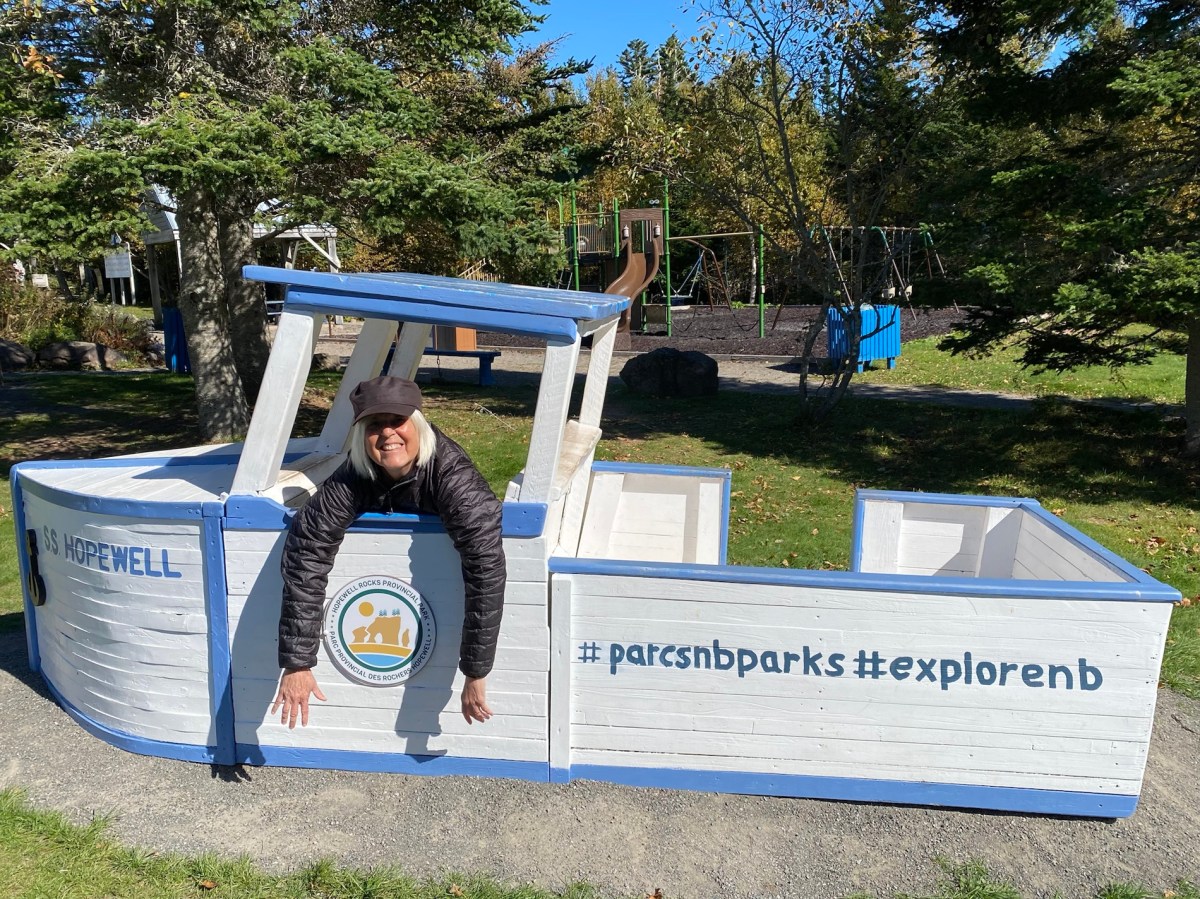


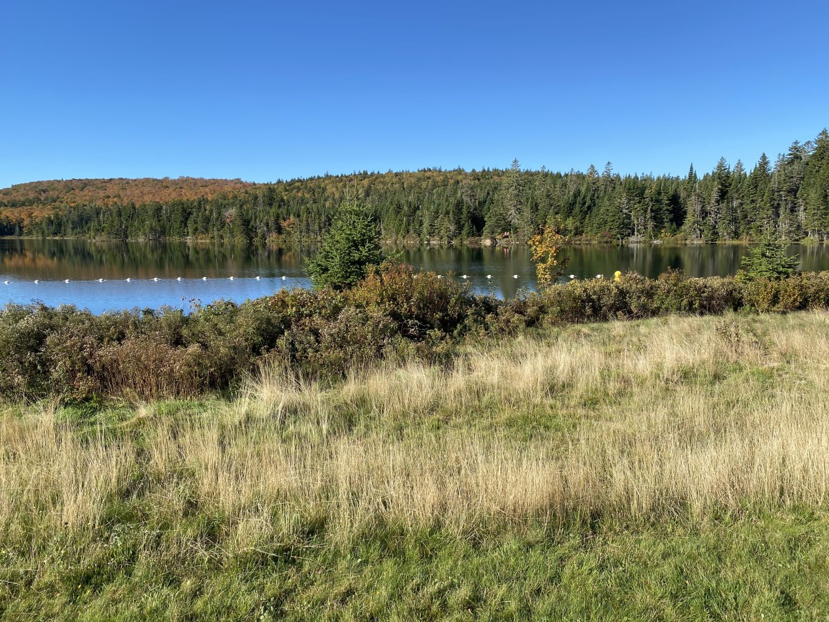


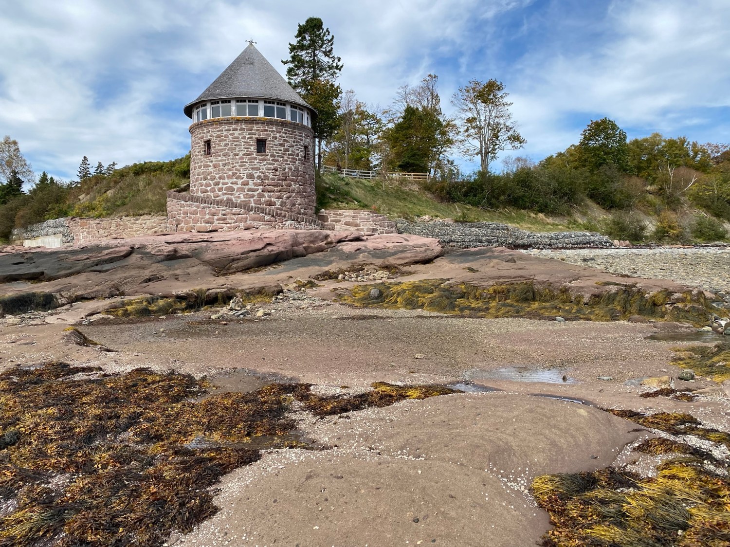


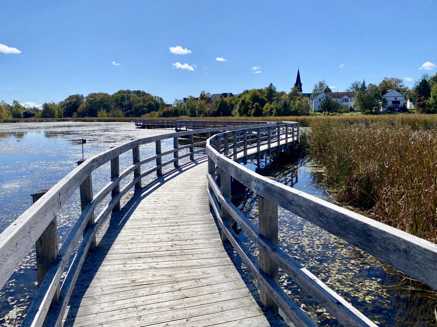


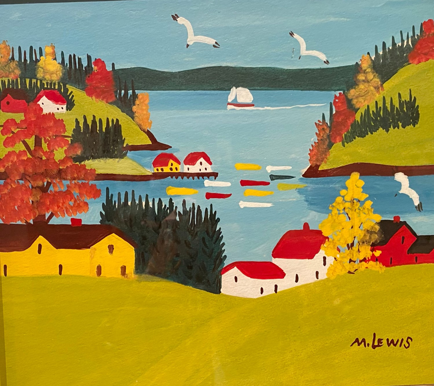


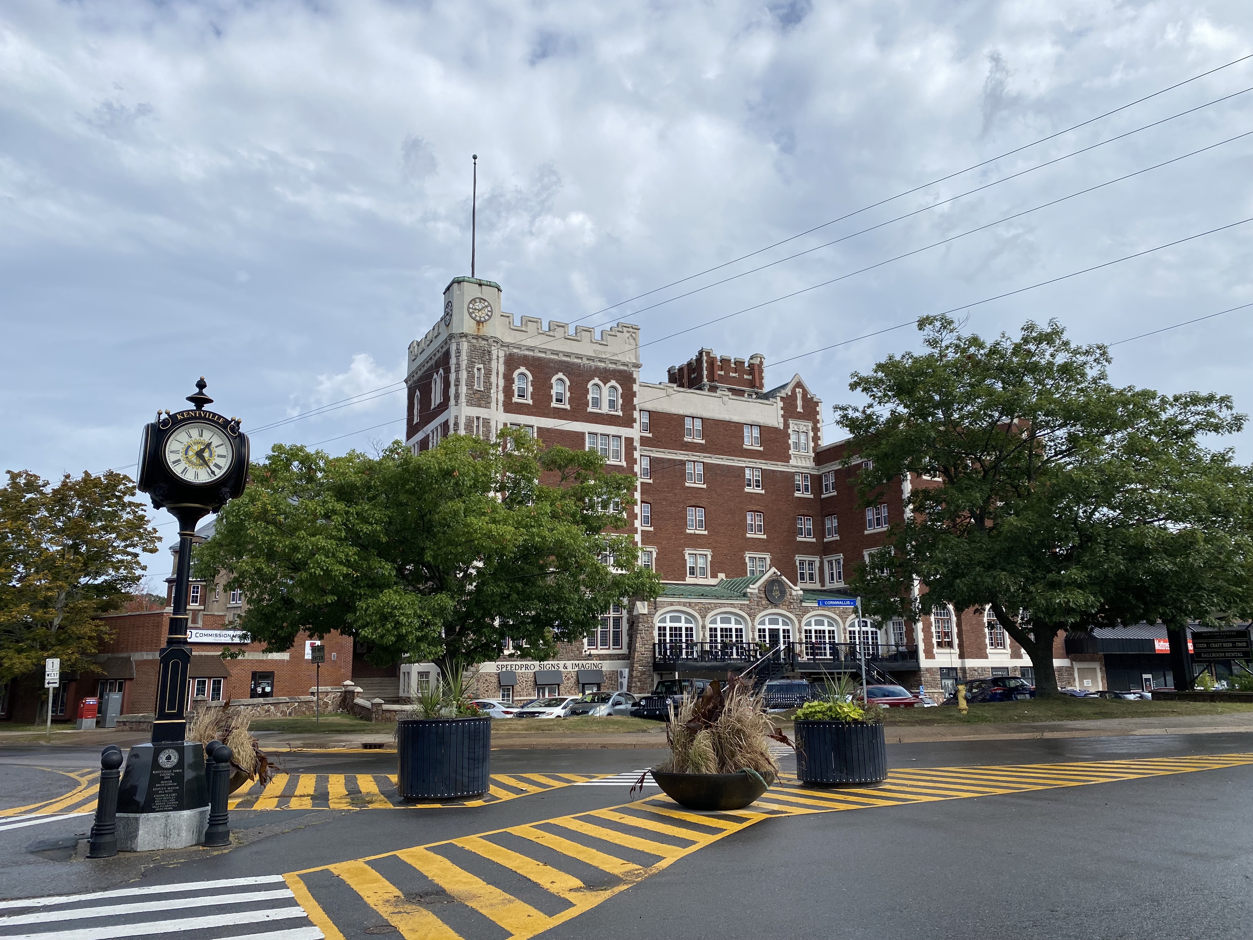


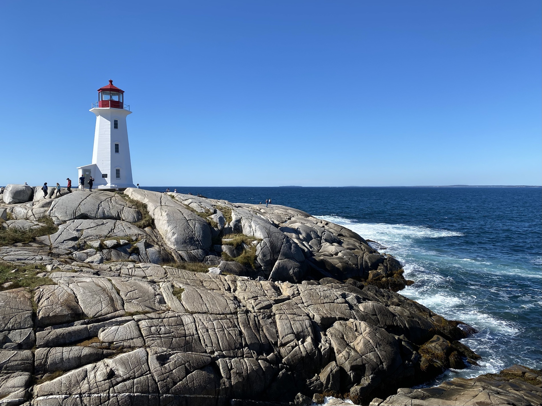


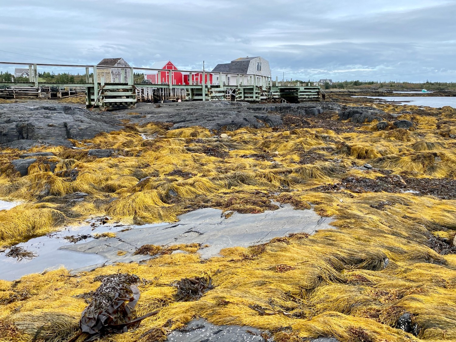


You must be logged in to post a comment.