Sunday, October 29, 2023: This morning, Mike flew home so he could be at work Monday morning and I packed up the car and began my 4-day solo drive home to Virginia.
Mike had taken the Toyota RAV to Jiffy Lube while we were in Albuquerque because the service light came on and he wanted everything to be in order before I drove the four days home starting Sunday morning. At Jiffy Lube they had changed the oil and topped off the air in the tires and rotated them so I should have been set.
Less than an hour after I’d left Albuquerque on I-40, it started sleeting and I looked at the outdoor temperature. It was 29°F degrees and ice was forming on my windshield. Suddenly the tire pressure light came on, so I pulled off at the first stop I could find. There I used the tire gauge and found all four tires had tire pressure of around 35. Of course I was out in the middle of nowhere and no mechanics were to be found on a Sunday, so I continued driving. At the next couple of towns I stopped to look for a Jiffy Lube but none were to be found. Every time I stopped I measured the tire pressure and it hadn’t changed. I figured I would keep stopping and measuring and if nothing changed I’d wait till I got to Oklahoma City or elsewhere to check them. In Amarillo, Texas a Walmart Superstore was open, so I took my car there to have them check the tires. Again, after having driven for 4 hours, the tire pressure was unchanged. The mechanic said maybe the sensor wasn’t working properly, but if I wanted that checked, he’d need to write up a ticket and I’d have to wait a while till they could get to me.
All of this was very time consuming so my trip to Oklahoma City took much longer than I hoped. The wind was blowing so hard when I stopped at a gas station and opened the door, the wind almost blew off the car door! This was my drive today: sleet, wind, fog and grey skies and constant worry about having a flat tire out in the middle of nowhere. Luckily I made it with all tires intact but who knew what the morning would bring.
I stayed at the Holiday Inn Express & Suites in Oklahoma City, North.
Holiday Inn Express & Suites in Oklahoma City, North
Holiday Inn Express & Suites in Oklahoma City, North
Steps: 3,643; Miles 1.54. Drove 561.2 miles. Weather Albuquerque: Hi 71°, Lo 28°. Oklahoma City: Hi 40°, Lo 31°. Rain/sleet.
Oklahoma City to Murphysboro, Illlinois
Monday, October 30: It was a long boring drive today, mostly through Oklahoma and Missouri.
After driving two long days from Albuquerque to Oklahoma City and then to Murphysboro, IL, I arrived at my sister Stephanie’s house where we ate sushi she’d bought from Kroger and toasted each other with beers. 🍻
We binge watched several episodes of TheWhite Lotus, which I’d seen but she hadn’t. It was fun to see the miniature Christmas village and the Halloween village she had created, much like what I saw at the Tinkertown Museum in Albuquerque.
Steph’s miniature Halloween village
Steph’s miniature Halloween village
Steps: 3,462; Miles 1.47. Drove 572.5 miles. Weather Murphysboro, IL: Hi 47°, Lo 24°. Mostly cloudy.
Halloween in Murphysboro, Illlinois
Tuesday, October 31: I spent Halloween day with Steph. We went out for a delicious lunch at Harbaugh’s Cafe (I had a delicious Earthquake sandwich). When the waitress asked which sides I’d like, I said “cottage cheese,” which shocked Stephanie. “Who orders cottage cheese?” she said, shaking her head. Hey, cottage cheese is good for you, or so I hear!
Earthquake sandwich: whole wheat bread, avocado, tomato, fresh slices mushrooms, onion, and melted smoked Gouda cheese; broiled, topped with sprouts and Ranch dressing & Cottage Cheese at Harbaugh’s Cafe
I dragged her shopping with me to maurices, where I bought 3 flannel shirts.
Later we went out to Thai Taste in Carbondale. Steph had decorated her house to the max for Halloween (even though she only gets a few trick-or-treaters) and we’d spent time in the afternoon at Walmart buying Halloween candy that she wouldn’t be tempted to eat after the night was over. However, we were enjoying our couple of beers and our meal so much at Thai Taste that we lost track of time and forgot about the trick-or-treaters. She saw on her security camera (on her phone while we were in the restaurant) one little group of trick-or-treaters ring her doorbell and turn away disappointed. Sadly she was left with all the Halloween candy since we’d missed the little action there was!
me with Steph forgetting all about the trick-or-treaters
Thai Taste
Thai Taste
While in the Walmart, we also bought some delicious red velvet cupcakes which we downed when we returned to her house. I couldn’t eat my second one after dinner, so I left it with her, much to her chagrin.
That evening, we watched more episodes of The White Lotus, all except the last episode.
Wednesday, November 1: The next day, I drove 8 hours to Abingdon, VA, mostly through the interminably long Tennessee.
I stayed at Country Inn and Suites by Radisson in Abingdon.
Steps: 2,898; Miles 1.23. Drove 520.4 miles. Weather: Murphysboro Hi 47°, Lo 26°. Abington Hi 41°, Lo 22°.
Abingdon, Virginia to Oakton, Virginia (home at last!)
Thursday, November 2: Finally, I drove another 6 hours on Thursday and finally made it home at 3:20 p.m. after 4 days of driving on my own. My tire pressure light was on for the entire trip, but my tire pressure never changed and I never stopped again to check it after Amarillo, Texas.
Luckily I made it home in time to see the remaining fall foliage.
fall foliage at home
fall foliage at home
Here’s my Polarsteps map showing my long drive home and our entire Tex-New Mex Road Trip (+ Atlanta).
Tex-New Mex Road Trip (+ Atlanta)
Steps 5,102; Miles 2.16. Drove 344 miles. Weather Abingdon Hi 51°, Lo 24°. Home: Hi 52°, Lo 30°.
Thursday, October 26, 2023: On Thursday morning, we started to make our way to Albuquerque, where we would stay 3 nights before Mike would fly home to Virginia. We took the High Road from Taos, a string of villages where Spanish heritage in New Mexico is most evident. Residents along this road have ancestors who settled in these towns during the 18th century.
We started by driving one more time to the end of our Taos neighborhood to see if we could see the Rio Grande Gorge in better light, but alas, it seemed the sun must be directly overhead to see it without shadows. We passed adobe houses that I could only dream of owning, if Mike and I could ever agree on where we’d like to settle in retirement.
Adobe houses in Ranchos de Taos
Adobe houses in Ranchos de Taos
Adobe houses in Ranchos de Taos
Taos Valley Overlook
Once underway, we took a short detour to Sipapu, an inexpensive ski resort, where we captured views from some roadside overlooks. We drove through Peñasco and Picurís Pueblo, and finally stopped briefly in Las Trampas (settled in 1751) to see the San José de Gracia Church (built 1760-1776), an example of New Mexican village church architecture and a National Historic Landmark. Vertical bell towers frame its thick adobe walls. Parishioners periodically re-mud the adobe walls, which are as much as six feet thick.
overlook near Sipapu
overlook near Sipapu
overlook near Sipapu
San José de Gracia Church
San José de Gracia Church
San José de Gracia Church
Next stop on the High Road was Truchas, where we found, tucked in a small plaza off the main street, the Nuestra Señora del Rosario de las Truchas Church, built in 1764.
overlook on the way to Truchas
Nuestra Señora del Rosario de las Truchas Church
We stopped for views near Córdova, originally named Pueblo Quemado after a nearly burned-out Indian Pueblo, which was permanently resettled in 1750 after Indian attacks.
viewpoint near Córdova
viewpoint near Córdova
viewpoint near Córdova
viewpoint near Córdova
viewpoint near Córdova
viewpoint near Córdova
We made a stop at the highlight of the High Road from Taos: Chimayó. It was lunchtime so we went to Rancho de Chimayó Restaurante, where we sat inside the old adobe home and shared a bowl of green chile soup and a salad. We imbibed in some kind of non-alcoholic pink frozen drink.
I also bought a couple of pairs of earrings made by Native Americans. 😍😍
Rancho de Chimayó Restaurante
Rancho de Chimayó Restaurante
me at Rancho de Chimayó Restaurante
Rancho de Chimayó Restaurante
The village of Chimayó was founded in the early 18th century, soon after the reconquest of New Mexico. The village surrounded a defensible plaza, much like other traditional villages.
El Santuario de Chimayó is a Roman Catholic pilgrimage site. The pilgrimage tradition began in 1945 as a commemoration of the Bataan Death March. Before that, in 1814, it had a reputation as a miraculous spot where a local farmer, Bernardo Abeyta, is said to have dug up a glowing crucifix; the carved wood figure was placed at the altar of the adobe chapel built in 1816.
The chapel is noteworthy for its six-foot crucifix and healing dirt. In the sanctuary complex is a small antechamber that holds el pocito, the little hole where the glowing crucifix was supposedly dug up. From this pit, people can scoop up a small portion of the exposed red earth to apply to ailing parts of the body. The parish apparently refreshes the dirt each year with new dirt blessed by the priests. The adjacent room holds abandoned crutches, prayers and handwritten testimonials.
The wife of a couple in front of us was digging up some soil for her skeptical husband who didn’t believe the dirt could cure his cancer. She told him to have faith, after all, how could it hurt?
Chimayó
El Santuario de Chimayó
El Santuario de Chimayó
El Santuario de Chimayó
El Santuario de Chimayó
El Santuario de Chimayó
grotto at El Santuario de Chimayó
grotto at El Santuario de Chimayó
El Santuario de Chimayó
El Santuario de Chimayó
mural at El Santuario de Chimayó
El Santuario de Chimayó
El Santuario de Chimayó
El Santuario de Chimayó
Nineteenth-century santeros (people who make religious images) created the unique religious folk art in the altar screens. Modern-day santeros added large santos (saints) in the chapel. Sadly absolutely no photography was allowed inside the church, but I was able to buy a few postcards which pictured the interior.
We also perused the Virgil Store, a kind of trading post, and went into the beautiful Santo Niño de Atocha Chapel, built in 1857.
Virgil Store
another store in town
Santo Niño de Atocha Chapel
Santo Niño de Atocha Chapel
Santo Niño de Atocha Chapel
Finally, we made our way to Albuquerque, arriving around 3:30 p.m.
Steps: 6,389; Miles 2.71. Drove 180.4 miles. Weather (Taos): Hi 66°, Lo 32°. (Albuquerque: Hi 73°, Lo 47°)
Tuesday, October 24, 2023: We arrived at our outstanding Airbnb in Taos, an adobe casita attached to the host’s house, late Tuesday afternoon. We made vodka tonics, assembled snacks and sat outside on the private patio, walled off for guests only.
What a fabulous place! It was a big open room with a partial textured glass partition between the living room and bedroom. Apparently it was once a potter’s studio. It had a wood-burning stove with a stash of wood which Mike had to figure out how to use. It was set in the high desert landscape of Ranchos de Taos. Although I loved the casita in Santa Fe (especially the hot tub), this one was even nicer with its New Mexican aesthetic.
our Taos casita
our Taos casita attached to the main house
our Taos casita
our Taos casita
our Taos casita
our Taos casita
our Taos casita
our Taos casita
our Taos casita
our Taos casita
our Taos casita
our Taos casita
Mike at our Taos casita
me at our Taos casita
our neighborhood in Ranchos de Taos
Our first night in Taos we went to Orlando’s New Mexican Cafe. It was a charming and colorful cafe with a line of people waiting; luckily the line wasn’t too long. We each had wine and I finally had my favorite Mexican dish that I order whenever I can, Chili Rellenos: two green chilis stuffed with Jack cheese , breaded and deep fried. Topped with choice of chili and cheese. Served with beans and posole.
The perfect way to begin our short stay in Taos.
Orlando’s New Mexican Cafe
Orlando’s New Mexican Cafe
Mike at Orlando’s New Mexican Cafe
Orlando’s New Mexican Cafe
me at Orlando’s New Mexican Cafe
Orlando’s New Mexican Cafe
Orlando’s New Mexican Cafe
Chili Rellenos
Orlando’s New Mexican Cafe
Orlando’s New Mexican Cafe
me with Mike at Orlando’s New Mexican Cafe
back at our cozy casita
San Francisco de Asis Church
Wednesday, October 25: The first stop on our one-day exploration of Taos was the San Francisco de Asis Church, completed in the early 19th century as a Franciscan mission. It sits in the middle of a quiet plaza ringed with adobe buildings and trees that cast artistic shadows over the doorway. As with every adobe structure, it must be refinished every year with a mixture of clay, sand and straw. It is then coated with a fine layer of water and sand, and buffed with sheepskin. This process is called enjarre.
Inside, the whitewashed walls hold the stations of the cross. Two Spanish Colonial reredos ( large altarpieces, screens, or decorations placed behind the altar in a church) decorate the altars.
This church has been used by artists such as Georgia O’Keeffe and Ansel Adams as subject matter for paintings and photographs.
driving out of our neighborhood in Ranchos de Taos
home in Ranchos de Taos
San Francisco de Asis Church
San Francisco de Asis Church
San Francisco de Asis Church
San Francisco de Asis Church
San Francisco de Asis Church
San Francisco de Asis Church
San Francisco de Asis Church
San Francisco de Asis Church
San Francisco de Asis Church
San Francisco de Asis Church
San Francisco de Asis Church
San Francisco de Asis Church
San Francisco de Asis Church
Río Grande Gorge
After visiting the mission church, we drove out west of Taos to the Río Grande Gorge, also called the Taos Gorge. It plummets 800 feet down into a shadowy basalt canyon as the river cuts through it. Besides the rushing water, seismic activity has also caused this rift in the earth’s surface. The crack extends north to just over the Colorado state line and south nearly to Española.
The bridge that spans the gorge was built in 1965. At that time there was no highway on the western side so it was referred to as the “bridge to nowhere.” Still, the American Institute of Steel Construction awarded it the “Most Beautiful Steel Bridge” in 1966. At 650 feet above the water, the cantilever truss was an amazing engineering feat. Today it is still the 7th highest bridge in the U.S.
Río Grande Gorge
bridge at Río Grande Gorge
Río Grande Gorge
Río Grande Gorge
Río Grande Gorge
bridge over Río Grande Gorge
bridge over Río Grande Gorge
Greater World Earthship Development
Of course, we had to stop by the Greater World Earthship Development visitor’s center since we were only a mile away after crossing the Rio Grande Gorge. I was curious to see it as our son Adam had spent some time here after going to Australia for a permaculture course soon after high school. Mike and I took the self-guided tour of the model of the basic Earthships: modular, low-priced homes that function entirely on collected rainwater and wind and solar power. The walls, usually built into hillsides, are stacked used tires packed with earth, while stacked bottles filled with cement, and crushed aluminum form the front walls. This architecture was developed in the late 20th- to early 21st-century by architect Michael Reynolds. Earthships are designed to withstand the extreme temperatures of a desert, managing to stay close to 70 °F (21 °C) regardless of outside weather conditions. They are designed to be “off-the-grid-ready” homes with minimal reliance on public utilities and fossil fuels.
We could only visit the model home and drive along the highway to see the Earthships from afar. The rest of the community is closed off to visitors unless they want to rent an Earthship for a night.
Greater World Earthship Development
Greater World Earthship Development
Greater World Earthship Development
Greater World Earthship Development
Greater World Earthship Development
Greater World Earthship Development
Greater World Earthship Development
Greater World Earthship Development
Greater World Earthship Development
Taos Pueblo
We visited Taos Pueblo, a village with two clusters of multistory mud-brick buildings at its core. Its claim to fame is that it, along with Acoma Pueblo, is the oldest continually inhabited community in the U.S. The current buildings are from the 1200s and are annually repaired and re-coated with mud. About 150 people (out of the community of around 1,900 residents of Taos Reservation) live here year-round. The town is designated a UNESCO World Heritage Site. The homes, stacked upon each other and reached by wooden ladders, have no electricity or running water.
Taos Pueblo
Taos Pueblo
Taos Pueblo
Taos Pueblo
me at Taos Pueblo
Taos Pueblo
Taos Pueblo
Taos Pueblo
Taos Pueblo
Mike at Taos Pueblo
me at Taos Pueblo
Taos Pueblo
Taos Pueblo
Taos Pueblo
Mike at Taos Pueblo
Taos Pueblo
Taos Pueblo
shop/home at Taos Pueblo
shop/home at Taos Pueblo
shop/home at Taos Pueblo
We wandered around and into some of the craft shops here. Mostly we loved taking photos of the picturesque village and especially the San Geronimo Church, built in 1850, which replaced the first mission the Spanish built in 1619, using forced Indian labor. The picturesque whitewashed gate to the church is a favorite subject for paintings and photographs. Absolutely no photography was allowed inside the colorful church, sadly.
San Geronimo Church
San Geronimo Church
door of San Geronimo Church
San Geronimo Church
building next to San Geronimo Church
San Geronimo Church
San Geronimo Church
San Geronimo Church
horses near Taos Pueblo
Taos Plaza
We spent a couple of hours at Taos Plaza where I did a little shopping for my birthday. 😍😍
Taos Plaza is the center of Taos, with many touristy shops selling Northern New Mexico foods and cultural items, including products made in Taos: chile ristras (strung pods of dried red chiles that are displayed near arches, doors and windows all over New Mexico), packaged food items, Southwestern jewelry, pottery, clothing, leather work, and Native American moccasins and drums.
Taos Plaza was established in 1615 but then destroyed in the Pueblo Revolt of 1680. New homes were built in 1710 but before long, fires gutted the block-style buildings. Now the structures that line the plaza are from around 1930.
Taos Plaza and the Taos Pueblo were the terminal points of the Camino Real de Tierra Adentro, or King’s Highway, from Mexico City.
Taos Plaza served for decades as the central meeting place in the valley and survived numerous fires that destroyed several older buildings.
We walked into the Hotel La Fonda de Taos, the smaller and older version of La Fonda in Santa Fe. We also found colorful murals in the town.
Homeland Security: Fighting Terrorism Since 1492
Hotel La Fonda de Taos
Hotel La Fonda de Taos
Taos Plaza
shop at Taos Plaza
me after a birthday shopping spree
mural near Taos Plaza
mural near Taos Plaza
Mabel Dodge Luhan’s house
I’d been interested in seeing Mabel Dodge Luhan’s house in Taos ever since I saw the 2009 TV movie Georgia O’Keeffe. Mabel Dodge (1879-1962) was a free-thinking woman who was a patron of the arts and held art salons in Greenwich Village, New York City and Florence, Italy. She followed her third husband to Taos in 1916. Eventually she got married again, to Taos Pueblo member Tony Luhan, and invited many famous artists to stay in her cobbled together house, where they thrived in their artistic pursuits. Her guests included novelist D. H. Lawrence, Greta Garbo, Willa Cather, photographer Ansel Adams, artist Georgia O’Keeffe, poet Robinson Jeffers, and psychiatrist Carl Jung.
Today the house operates as a hotel and retreat and it was closed for a special event when we visited. Sadly we couldn’t go inside, but we were able to walk around the grounds. I could almost feel the creative spirit wafting about in the air at this fabled place.
Mabel Dodge Luhan’s house
Mabel Dodge Luhan’s house
birdhouses at Mabel Dodge Luhan’s house
Mabel Dodge Luhan’s house
door at Mabel Dodge Luhan’s house
birdhouses at Mabel Dodge Luhan’s house
Mabel Dodge Luhan’s house
porch at Mabel Dodge Luhan’s house
grill at Mabel Dodge Luhan’s house
We drove to the end of the road where our Airbnb was situated and found the Río Grande Gorge Recreation Area: Taos Valley Overlook. Sadly the shadows in the canyon made photography difficult.
Río Grande Gorge Recreation Area: Taos Valley Overlook
Río Grande Gorge Recreation Area: Taos Valley Overlook
Río Grande Gorge Recreation Area: Taos Valley Overlook
Río Grande Gorge Recreation Area: Taos Valley Overlook
Río Grande Gorge Recreation Area: Taos Valley Overlook
Río Grande Gorge Recreation Area: Taos Valley Overlook
Río Grande Gorge Recreation Area: Taos Valley Overlook
Río Grande Gorge Recreation Area: Taos Valley Overlook
Río Grande Gorge Recreation Area: Taos Valley Overlook
Río Grande Gorge Recreation Area: Taos Valley Overlook
Río Grande Gorge Recreation Area: Taos Valley Overlook
The Love Apple
To celebrate my 68th birthday, we went to The Love Apple in Taos. Frank, the guide at the Georgia O’Keeffe house, had recommended it to Mike, who was looking for somewhere nice to take me. The Love Apple, or La pomme d’amour, emphasizes local, organic home cooking.
The restaurant is housed in what was once known as the Placitas Chapel. This little Catholic church was built around the 1800s and was in operation for 100 years.
We sat outside, but it wasn’t too cold because they had space heaters and we dressed warmly. The place had a really nice ambiance.
We began with Buttermilk Yellow and Blue Cornbread. We shared a bowl of the tomato soup of the day. I enjoyed a Homemade Baked Tamale and Oaxacan Style Mole (Local sauteed greens and sweet corn baked tamale topped with red chile mole finished with a farm-fresh fried egg and crême fraice). Mike had a Polenta Bolognese (Santa Ana Polenta with local beef & Pancetta Bolognese served with house-made lemon ricotta).
It was another memorable birthday to add to all the memorable ones I’ve enjoyed in my life. I’m filled with gratitude for every new year I get.
The Love Apple
entrance to The Love Apple
outdoor dining at The Love Apple
The Love Apple
me at The Love Apple
mural at The Love Apple
Mike at The Love Apple
Buttermilk Yellow and Blue Cornbread
Homemade Baked Tamale and Oaxacan Style Mole
Mike with Polenta Bolognese at The Love Apple
me with Homemade Baked Tamale and Oaxacan Style Mole at The Love Apple
We should have stopped when we were ahead after my birthday dinner, but we’d read the Adobe Bar at the Taos Inn was a lively spot to go. Lounge music was playing and a bunch of older folks were dancing. I know, I know, I’m old too. But I don’t want to act like I am. It really wasn’t my scene at all and I definitely didn’t need another margarita after all I’d had to eat and drink at the Love Apple. So, this place was a bust, in my humble opinion.
pretty door near Taos Plaza
Taos Inn Sign
Adobe Bar at the Taos Inn
Adobe Bar at the Taos Inn
Steps: 9,532; Miles: 4.04. Drove 79.7 miles. Weather: Hi 66°, Lo 31°.
Tuesday, October 24, 2023: On Tuesday morning, we left our Santa Fe casita (😰😰😥) and headed to Taos by way of Abiquiú and Ghost Ranch. We only passed through Española, but we couldn’t help stopping to check out the fabulous murals there. Also, we drove over the Río Grande which we had followed intermittently from the border of Mexico in Big Bend National Park.
murals in Española
murals in Española
murals in Española
murals in Española
murals in Española
a bridge crossing the Rio Grande near Española
Georgia O’Keeffe’s Abiquiú house
We stopped first in Abiquiú (pronounced A-bih-kyoo) to see Georgia O’Keeffe’s beautiful house. We were lucky to get into the 11:00 tour of the house. Reservations were required and we didn’t have them but we called about a half hour before we were due to arrive and someone had just cancelled. The tour guide, Frank, was fabulous and very knowledgeable about Georgia O’Keeffe and her house.
The O’Keeffe home and studio reflect a blend of Native American and Spanish Colonial building styles. The oldest rooms of the house were likely built in 1744. The house was expanded in the 19th century into a pueblo-style adobe (mud brick) hacienda, with rows of rooms organized around a common open space, or plazuela.
O’Keeffe lived in the house for the last 35 years of her life. She loved its location in the midst of northern New Mexico’s beauty and for how it inspired her artistically. She especially felt she had to have a particular door in the courtyard that she painted numerous times. She said, “That wall with a door in it was something I had to have.”
She owned two homes in New Mexico, including the one at Ghost Ranch, about 12 miles away from her Abiquiú home. O’Keeffe purchased the larger home in the village of Abiquiú for its well-irrigated garden and the comfort it offered in winter. She stayed at Ghost Ranch in summers.
O’Keeffe loved her garden, which provided her with fresh fruits and vegetables.
outside Georgia O’Keefe’s Abiquiu home
our guide Frank
Georgia O’Keeffe’s garden
Georgia O’Keeffe’s garden
Georgia O’Keeffe’s garden
Georgia O’Keeffe’s garden
Georgia O’Keeffe’s garden
We took a peek through the window into the sitting room of the house, which is now in neutral colors. Frank showed us a photo of a more colorful room. O’Keeffe changed the color scheme as she became increasingly enamored with the monotone colors of the desert.
the living room now
the living room in a more colorful past
The 5,000-square-foot compound was in ruins in 1945 when she purchased the home from the Catholic Church. For the next four years, O’Keeffe supervised its restoration, which was carried out by her friend, Maria Chabot. O’Keeffe finally made Abiquiú her permanent home in 1949, living there until 1984. She died in Santa Fe on March 6, 1986, at the age of 98. The O’Keeffe Home and Studio was designated a National Historic Landmark in 1998 and is now part of the Georgia O’Keeffe Museum.
the courtyard
O’Keeffe’s courtyard and her collections
O’Keeffe’s courtyard and her collections
O’Keeffe’s courtyard and her collections
the door O’Keeffe had to have
the door O’Keeffe had to have
the living room from inside
living room from inside
fossil in the house
a peek into a courtyard with one of O’Keeffe’s sculptures
The kitchen area was beguiling, with the light and the spare but cozy atmosphere. I loved perusing the dishes, cookbooks, teas and spices in her cupboard.
The dining room
O’Keeffe’s kitchen
O’Keeffe’s kitchen
O’Keeffe’s kitchen
O’Keeffe’s kitchen
cupboard in the kitchen
cookbooks
a small table in an adjacent room
dishes
O’Keeffe’s kitchen
O’Keeffe’s cupboards
O’Keeffe’s cupboards
O’Keeffe’s cupboards
O’Keeffe’s cupboards
O’Keeffe’s cupboards
The artist’s studio, accessed across an open courtyard, had amazing views over the Abiquiú Valley.
crossing another courtyard from the main house to the studio
the driveway
outside the studio
O’Keeffe’s studio
sculpture in O’Keeffe’s studio
O’Keeffe’s studio
view from the studio
O’Keeffe’s studio
O’Keeffe’s studio
photo of Georgia O’Keeffe in her studio
Finally, we saw O’Keeffe’s bedroom, which had fabulous views of the valley. I could imagine waking up in this room everyday with great pleasure.
O’Keeffe’s studio
view from O’Keeffe’s studio
view from O’Keeffe’s studio
Photo of O’Keeffe in her bedroom
fireplace in the bedroom
O’Keeffe’s bed
view from the bedroom
view from the bedroom
view from the bedroom
view from the bedroom
view from the bedroom
Outside the house
outside the house
view from outside the house
Our guide Frank told us that O’Keeffe traveled extensively. She didn’t travel for travel’s sake or because she liked to travel. She said, “I go around the world… to see what’s there — and to see if I’m in the right place (1968).” I can understand this sentiment and feel like this myself; I’m always in search of the place I’m meant to be, which is definitely NOT where I live in northern Virginia. This northern New Mexico landscape is definitely one in which I can envision myself being “in the right place.”
Georgia O’Keeffe Museum
After the house tour, we perused the small Georgia O’Keeffe Museum, where we found items from her travels. She kept some souvenirs as decorative items, like the seashell necklace and Italian velvet shoes. Others reflect the unique style of the country she visited, such as silver brooches from Peru, or to highlight the country of origin, like a “Mexico” wallet and “Korea” handkerchief. O’Keeffe even purchased cooking ingredients abroad, such as saffron from Spain. Hanging above the case are two scarves, one from her visit to India featuring a block print design, the other featuring a mermaid that possibly came from Fiji. Between them is a jacket from Mexico that O’Keeffe regularly wore.
The reproduction of a painting of Mount Fuji was kept by O’Keeffe in her personal collection, and speaks to her love of Japan. The artist traveled there twice in 1960 and both times she visited Mount Fuji and stayed at the Imperial Hotel in Tokyo, which was designed by Frank Lloyd Wright.
Georgia O’Keeffe collected Japanese kimonos and wore them in her daily life. The one included in the Museum, featuring a hand-painted rendering of Mount Fuji, was purchased during a visit to Japan. She also purchased many bolts of fabric while abroad, including a printed cotton which she used to replicate a popular Western pattern at the time — “The Hollywood Girl” outfit — which consisted of an apron blouse and skirt.
O’Keeffe was a collector of handheld fans. Each in the collection features a unique design and material, ranging from the inexpensive paper fan from Japan and plastic fan from India to the intricate lace fan from western Europe. Hand fans have been used to provide relief from heat since ancient times and are still offered all over the world. They make perfect souvenirs when traveling to warmer climates.
O’Keeffe during her travels
Italian velvet shoes and seashell necklace
scarves from India and Fiji and a jacket from Mexico
Tenugui, or cotton hand towels, from Japan
byobu, a miniature version of folding room panels for display on a tabletop or in an alcove
Untitled (Mt. Fuji), 1960 Reproduction by Georgia O’Keeffe
Japanese kimono and “The Hollywood Girl”-inspired blouse and skirt
collection of fans
monogrammed weekend bag, travel alarm clock, voltage adaptor, and pocket-sized conversion rate cards
Travel agency brochures
O’Keeffe’s Abiquiú Home and Studio: Floor Plan
O’Keeffe’s Abiquiú Home and Studio: Garden Plan
table in museum modeled after the table in her studio
Abiquiú Inn
After our visit to the museum, we wandered around the grounds of the adjacent Abiquiú Inn, located along the ancient Rio Chama, north of Santa Fe and southwest of Taos, in beautiful Abiquiú. It offers a great variety of lodging choices and the grounds are stunning.
Abiquiu Inn
grounds of the Abiquiu Inn
grounds of the Abiquiu Inn
grounds of the Abiquiu Inn
grounds of the Abiquiu Inn
grounds of the Abiquiu Inn
grounds of the Abiquiu Inn
grounds of the Abiquiu Inn
grounds of the Abiquiu Inn
grounds of the Abiquiu Inn
grounds of the Abiquiu Inn
Bodes & the Río Chama
I had read in our guide book that Bodes (pronounced BO-deez) General Store in Abiquiú had green chile cheeseburgers 🍔, along with gas and a lot of other stuff. I had been hankering for a green chile cheeseburger during our entire trip. So we stopped and waited for the burgers to be assembled right off the grill and then savored bite after bite of pure deliciousness. Yum!
While eating at Bodes, we chatted with a young woman who had recently bought a piece of property nearby and had made her house out of a shipping container. It seems people living in these parts are rugged and adventurous people.
Bodes
Bodes
green chile cheeseburger from Bodes
golden trees near Bodes
We stopped on the way to Ghost Ranch at an overlook where we could see magnificent views of the striking valley formed by the Río Chama.
overlook to the Río Chama
overlook to the Río Chama
overlook to the Río Chama
overlook to the Río Chama
overlook to the Río Chama
me at the Río Chama overlook
Ghost Ranch
Ghost Ranch today is a 21,000 acre retreat owned by the Presbyterian Church. It is best known because Georgia O’Keeffe owned a small parcel of the land and maintained a studio there. We could see Chimney Rock, one of many hikes on the property.
We didn’t stay long; we only went to see Georgia O’Keeffe’s studio and small house here.
Ghost Ranch
Chimney Rock
Ghost Ranch
Ghost Ranch
Ghost Ranch
Ghost Ranch
Ghost Ranch
O’Keeffe’s home at Ghost Ranch
O’Keeffe’s home at Ghost Ranch
O’Keeffe’s home at Ghost Ranch
O’Keeffe’s home at Ghost Ranch
Low Road to Taos
We sadly left the Abiquiu area behind to take the Low Road to Taos. About 90 miles north of Santa Fe, Ohkay Owingeh Pueblo, formerly known as San Juan Pueblo, sits on the east side of the Rio Grande River. People have been living at the site since A.D. 1200. The neo-Gothic stone and brick church of San Juan Bautista seems strangely out of place in comparison to the one-story adobe buildings surrounding it. The church reflects a long history of interaction between the Spanish and Pueblo Indians in New Mexico. Originally, Mission San Juan Bautista was founded as part of Don Juan de Oñate’s first settlement in New Mexico that dates from 1598.
Although the Spanish settlement moved, the Franciscan priests maintained Mission San Juan Bautista until it was turned into the local Catholic parish in 1826. Today the pueblo is one of the Eight Northern Pueblo Tribes. Both San Juan Pueblo – renamed Ohkay Owingeh Pueblo in 2005 – and the Our Lady of Lourdes Grotto – part of the historic brick church that replaced the adobe mission – are listed in the National Register of Historic Places.
The Shrine of Our Lady of Lourdes, built in 1889-1890, was conceived as a place of pilgrimage for people of faith wanting to honor the Virgin. It was built on or near the site on which the third parish church was built in 1645 and later destroyed in the Pueblo Revolt of 1680. The shrine is one of only 19 buildings in the United States built entirely out of lava rock.
San Juan Pueblo (Ohkay Owingeh) was the end point of the Camino Real de Tierra Adentro (Royal Road of the Interior Land), also known as the Silver Route, a Spanish 2,560-kilometre-long (1,590 mi) road that led here from Mexico City. It was used from 1598 to 1882. It was the northernmost of the four major “royal roads” that linked Mexico City to its major tributaries during and after the Spanish colonial era.
San Juan Bautista
San Juan Bautista
San Juan Bautista
Our Lady of Lourdes Grotto
Our Lady of Lourdes Grotto
We continued on the Low Road to Taos, which follows the winding Río Grande up into the mountains, mostly on Rt. 68. We stopped near Embudo to see the Classical Gas Museum, a front yard filled with old service station accoutrements. It wasn’t actually open, so I hoped the owner didn’t mind that I walked on his dirt driveway and took a few photos.
We stopped at a couple of overlooks just to admire the pretty river snaking its way through the yellowing cottonwoods.
Overlook of the Rio Grande
me along the Rio Grande
Classical Gas Museum
Classical Gas Museum
Classical Gas Museum
Classical Gas Museum
Classical Gas Museum
Classical Gas Museum
Classical Gas Museum
Classical Gas Museum
another overlook along the Rio Grande
We arrived in Taos at around 4:00, after enjoying one of the most scenic days on our Tex-New Mex Road Trip.
Steps: 5,100; Miles 2.16. Drove 172.1 miles. Weather (Abiquiu) Hi: 69°, Lo 39°.
Monday, October 23, 2023: On Monday, we spent the entire day in Santa Fe’s Old Town. Our first stop was the New Mexico State Capitol, known as the Roundhouse; it is the only round capitol building in the country. It is a combination of New Mexico Territorial style, Pueblo adobe architecture and Greek Revival adaptations. It was dedicated on Dec. 8, 1966.
From a bird’s-eye view, the Roundhouse resembles the Zia sun symbol, which is also emblazoned on the New Mexico state flag. The image, which originated at Zia Pueblo, incorporates elements representing the sun’s rays, the four directions, the four seasons, and the four phases of life.
approaching the New Mexico State Capitol, aka the Roundhouse
sculpture at the Roundhouse
New Mexico State Capitol (the Roundhouse)
The Roundhouse
statue at entrance to the Roundhouse
The New Mexico Capitol Art Collection was created in 1991 and consists of nearly 600 artworks valued at over $5 million. The Collection includes paintings, photography, works on paper, sculpture, mixed media, textiles, ceramic and glass works, as well as furniture.
New Mexico Capitol Art Collection
New Mexico Capitol Art Collection
New Mexico Capitol Art Collection
“Where All True Paths Meet” 1994 by Carl Schuman
“Slide 2008” by Laura Rosenfeld
“Plaza of Santa Fe in the 1800s” 1992 by Frederico M. Vigil
“My Lowrider Heaven” 1993 by Anita Rodriguez
“Harlot” 1997 by Pat Garey
“Hacienda Shadow Play” 2009 by Albert Handell
“Last Light” 2008 by Albert Handell
“The Trailer” by Delmas Howe
“Blues Lament” 2001 by Reginald Gammon
“The Cat Who Came to Dinner” 1996 by Suzy Shipp
“Ristras II” 1994 by Marnie Johnson
“Earth Forms #643” 1985 by Cliff Harmon
New Mexico Capitol Art Collection
New Mexico Capitol Art Collection
New Mexico Capitol Art Collection
New Mexico State Capitol
New Mexico Capitol Art Collection
New Mexico Capitol Art Collection
New Mexico Capitol Art Collection
New Mexico Capitol Art Collection
“Ghost of Bibo at Cubero trading post” 2022 by Jerry R. West
“Spikes and Splatters” by Helen K. Tindel 2021
“Untitled” by Margarete Bagshaw
“Untitled” by Margarete Bagshaw
New Mexico Capitol Art Collection
New Mexico Capitol Art Collection
New Mexico Capitol Art Collection
“Buffalo, 1992” by Holly Hughes
“Fancy Shawl Dancer” 1993 by John Nieto
“Hoshonzeh” 1992 by Douglas Johnson
“Reredo/Altar Screen” 1991 by Ramon Jose Lopez
New Mexico Capitol Art Collection
me outside the New Mexico State Capitol
San Miguel Mission
We next visited the Spanish colonial San Miguel Mission, originally built around 1610. It is often referred to as the oldest church in the United States (not including Puerto Rico). The church was rebuilt twice, once in the mid- to late-17th century, and again in 1710 following the Pueblo Revolt. In both cases earlier pieces of the building may have been reused, though it is unclear to what extent. The wooden reredos (altar screens) featuring a wooden statue of Saint Michael the Archangel wielding a sword, dating back to at least 1709, were added in 1798. The bell that hung in the bell tower prior to 1872 is on display inside the building.
one of many adobe buildings in Santa Fe
San Miguel Mission
San Miguel Mission
San Miguel Mission
San Miguel Mission
San Miguel Mission
San Miguel Mission
De Vargas Street House (the Oldest House)
We stopped into the De Vargas Street House, often referred to as the Oldest House. Attached to a gift shop, it is a historic building in Santa Fe which is often said to be one of the oldest buildings in the United States. The original date of construction is unknown but the majority of the building is believed to date to the Spanish colonial period (post-1610).
De Vargas Street House
me outside the gift shop adjacent to De Vargas Street House
De Vargas Street House
De Vargas Street House
De Vargas Street House, or the Oldest House
The Oldest House
Wooden Indian inside the gift shop
De Vargas Street House
another adobe building in Santa Fe
Loretto Chapel
We visited the Loretto Chapel, where a story is told about the miraculous staircase there.
When the Sisters of Loretto built a Gothic chapel for their Santa Fe school for girls in 1878, a problem remained: there was no way to access the choir loft, and any reasonable designs for staircases took too much space in the small chapel. The nuns were told no staircase could be built – instead, some other means of ascending to the loft would be required.
The nuns turned to St. Joseph, asking for his assistance through a novena. On the ninth and final day of the novena, a stranger appeared looking for work, accepting the commission to build a staircase.
The mysterious man constructed the staircase in secret, consulting with no one on the details and completing the work with the hand tools he possessed. Some versions of the story have the construction occurring in a single night; another version over the course of a week; still other versions over the course of months. At the end of the commission, the mysterious carpenter simply vanished, leaving Santa Fe without seeking recognition or payment.
The resulting staircase has been described as not merely mysterious, but miraculous. The compact spiral staircase completes two rotations before reaching the choir loft, and the entire structure lacks a central support. The intricately detailed stairs are held together with wooden pegs and glue rather than metal nails. To add to the puzzling story of the staircase, the wood from which they are built is of an unknown variety: although it has been identified as a type of spruce, the species of tree from which it was gathered has not been discovered. Experts agree, at the very least, that the wood is not from any species of tree found in New Mexico.
Loretto Chapel
Loretto Chapel
the mysterious staircase model in theLoretto Chapel
Loretto Chapel
the mysterious staircase in the Loretto Chapel
Loretto Chapel
Loretto Chapel
Loretto Chapel
La Fonda on the Plaza
La Fonda on the Plaza, sitting at the end of the Old Santa Fe Trail and in the very heart of the city, has been a central part of the culture and commerce of the community for generations.
Various inns have operated on this site since 1609, making it the oldest hotel site in the United States.
La Fonda on the Plaza
La Fonda on the Plaza
La Fonda on the Plaza
La Fonda on the Plaza
lobby of La Fonda on the Plaza
restaurant in La Fonda on the Plaza
artwork in La Fonda on the Plaza
The Cathedral Basilica of Saint Francis of Assisi
I was curious to see The Cathedral Basilica of Saint Francis of Assisi, a Roman Catholic cathedral in downtown Santa Fe, after reading Death Comes for the Archbishop by Willa Cather. The cathedral was built by Archbishop Jean Baptiste Lamy between 1869 and 1886 on the site of an older adobe church, La Parroquia (built in 1714–1717). An older church on the same site, built in 1626, was destroyed in the 1680 Pueblo Revolt.
The character in Cather’s book is based on French-born Archbishop Lamy, who built the cathedral. In dramatic contrast to the surrounding adobe structures, Saint Francis Cathedral was designed in the Romanesque Revival style. Sadly, as the cathedral was closed on Monday, we weren’t able to go inside.
The Cathedral Basilica of Saint Francis of Assisi
The Cathedral Basilica of Saint Francis of Assisi
The Cathedral Basilica of Saint Francis of Assisi
The Cathedral Basilica of Saint Francis of Assisi
The Cathedral Basilica of Saint Francis of Assisi
The Cathedral Basilica of Saint Francis of Assisi
The Cathedral Basilica of Saint Francis of Assisi
The Cathedral Basilica of Saint Francis of Assisi
statue of Archbishop Jean Baptiste Lamy at The Cathedral Basilica of Saint Francis of Assisi
Izmi Sushi Bar
We had lunch at Izmi Sushi Bar, where I enjoyed a New Mexico roll: shrimp tempura, green chile, red pepper 🌶️ , avocado 🥑, and crab mix. Mike had Green Chile Two: Green Chile tempura, Tempura shrimp & spicy crab. As we sat near the window eating and sharing a lemonade, we watched a crowd of protesters march by protesting Israel’s relentless bombardment of Gaza, and the genocide that was (& still is) happening there.
ristras, or dried chili peppers
Inn of the Anasazi
IZMI Sushi Asian Cuisine
sushi at IZMI
Museum of Contemporary Native Arts
Los Poblanos Farm Shop
The Old Spanish Trail
New Mexico Museum of Art
We visited the New Mexico Museum of Art in Santa Fe in the afternoon. The 1917 building itself is a work of art. It is an example of Pueblo Revival Style architecture, and synthesizes Native American and Spanish Colonial design styles.
It has a beautiful courtyard with six murals on the north walls painted by Will Shuster in 1934. The Museum of New Mexico commissioned the murals as a Federal Emergency Relief Administration (FERA) project. Painted at the height of the Great Depression, the murals honor the spiritual, ceremonial, and agricultural traditions of the Pueblo Indians.
The four large murals, inspired by the writings of ethnologist Alice Gunningham Fletcher, portray earth, sky, water, and emergence from the underworld (sipapu), while the two small murals display aspects of daily life: winnowing wheat and making pottery.
Shuster, born in Philadelphia in 1893, came to New Mexico in 1920 after World War I. He thought Santa Fe would be the perfect place to recover from tuberculosis that developed from a gas attack during the war.
Shuster soon became a well-known artist and a prominent figure in the Santa Fe community. He is best known as a member of Los Cinco Pintores (The Five Painters), a group of young, Bohemian artists recovering from the psychological effects of the war.
New Mexico Museum of Art
New Mexico Museum of Art
Willa Cather stone
Georgia O’Keefe stone
New Mexico Museum of Art
courtyard at New Mexico Museum of Art
Will Shuster “Voice of the Earth” 1934
“The Voice of the Sipapu” 1934 by Will Shuster
“Pottery Making” 1934 by Will Shuster
“Voice in the Sky” 1934 by Will Shuster
“The Voice of the Water” 1934 by Will Shuster
“Exodus: Influencias Positivas y Compadrazgo” 1998 by Frederico M. Vigil
New Mexico Museum of Art
Inside, the exhibition on “The Nature of Glass” explores how artists working in glass have engaged with the natural world as content for their work. It also examines the nature of glass as a medium, exploring the technical and material aspects of glass, the qualities of the medium, and the process of how artists work with glass.
The Nature of Glass
The Nature of Glass
“Cat” 2004-2005 by Raquel Stolarski-Assael
“Untitled (acorns)” 1996 by Flo Perkins and “Seeking Sun” 2004 by Flo Perkins / “Moon Series Vase” 1976 by John Lewis
“Untitled (acorns)” 1996 by Flo Perkins and “Seeking Sun” 2004 by Flo Perkins
“For the Basket of Corn” 1994 by Tony Jojola
“Turquoise Persian Set” 1989 by Dale Chihuly
“Eve and Pink Sticks” by Ginny Ruffner
Another exhibit I enjoyed was on Rick Dillingham (1952-1994), who worked in the art of ceramics by piecing together imperfect fragments to explore new ideas of wholeness.
Rick Dillingham exhibit
Rick Dillingham exhibit
Rick Dillingham exhibit
Rick Dillingham exhibit
Rick Dillingham exhibit
Rick Dillingham exhibit
“Globe, 3-92-2” 1993 by Rick Dillingham
Rick Dillingham exhibit
Rick Dillingham exhibit
Rick Dillingham exhibit
Rick Dillingham exhibit
Finally, we saw some of the museum’s permanent collection, which features reflections of the New Mexican indigenous people, culture and ceremonies, and the uniquely beautiful landscape of the high desert.
New Mexico Museum of Art permanent collection
“Holy Week in New Mexico / Penitente Procession” 1919 by William Penhallow Henderson
“Antelope Dance” 1919 by B.J.O Nordfeldt
New Mexico Museum of Art
“Hopi Pottery Maker” 1927 by Catharine Carter Critcher
“Pueblo Pottery” 1917 by Henry C. Balink
New Mexico Museum of Art
“Dance at Taos” 1923 by Ernest Blumenschein
“Cui Bono?” c. 1911 by Gerald Cassidy
“Washington Landscape with Peace Medal Indian” 1976 by T.C. Cannon
“Portrait of Gerald Marr” c. 1952-1953 by Peter Hurd
“The Stoic” 1914 by Joseph Henry Sharp
“The Black Shawl” 1933 by Esquípula Romero de Romero
“My Gate on the Camino” 1928 by Andrew Dasburg
“El Santo” 1919 by Marsden Hartley
“Music in the Plaza” 1920 by John Sloan
“Our Washerwoman’s Family – New Mexico” c. 1918 by Bert Geer Phillips
“The Springtime Rainbow” 1923 by Jozef G. Bakos
“Drouth Survivors” 1984 (conceived in 1936) by Alexandre Hogue
New Mexico Museum of Art
New Mexico Museum of Art
“Pablita Passes (Walking Rain)” 1916 by Victor Higgins
Santa Fe Plaza
After leaving the museum, we made our way to Santa Fe Plaza, which has been the heart of downtown Santa Fe for 400 years and hosts Indian and Spanish markets and other community gatherings and concerts.
We stopped to rest at the Plaza Cafe where we shared a Quarti Leches cupcake and I enjoyed a Mexican Mocha and Mike a Negra Modelo.
After our full and busy day in Santa Fe, we returned to our cozy casita where we soaked in the hot tub with vodka tonics and then heated up our leftovers from last night’s take-out dinner from The Wrap.
Steps: 11,968; Miles 5.07. Drove 36.5 miles. Weather Hi 74°, Lo 42°.
Sunday, October 22, 2023: This morning, after having a leisurely breakfast in our Santa Fe Airbnb, we decided, since it was a Sunday and downtown Santa Fe was sure to be crowded, to instead explore all the places outside of Santa Fe that we wanted to see.
Pecos National Historical Park
We started by going to Pecos National Historical Park, which preserves what was once a cultural crossroads through which hunters and gatherers, traders, conquerors and explorers, immigrants, soldiers, ranchers and tourists passed.
Because of the village’s commanding location near Glorieta Pass, Pecos Pueblo hosted a lively trade between the Plains Indians hunting to the east and Rio Grande Pueblos farming to the west. Situated on a high ridge near abundant water supplies, it grew into one of the largest and most powerful pueblos, rising four to five stories high and home to some 2,000 people.
The Pecos people’s life and traditions were deeply rooted in ancient Puebloan customs and religious beliefs. Kivas (underground ceremonial rooms) were connections to the spiritual world. The people believed prayers, rituals and offerings brought good fortune and helped maintain balance and harmony in all things. The Pecos followed ancestral farming practices and set aside food for the winter in massive storerooms.
Despite the emphasis on harmony, warfare was common. With 500 warriors, Pecos was considered the dominant power, as newcomers to the region soon realized.
Pecos National Historical Park
Pecos National Historical Park
Pecos National Historical Park
Pecos National Historical Park
Pecos National Historical Park
Pecos National Historical Park
stamps for Pecos National Historical Park in my National Park passport
Pecos National Historical Park
Pecos National Historical Park
Pecos National Historical Park
By the mid-1500s, this prominent pueblo, known throughout the Pueblo world, had become an attractive target for the Spanish Conquistadors during their explorations of the Southwest. Coronado visited in 1541. The Spanish established a mission here after they settled here in 1598. Padre Ortiz built the first church around 1617 or 1618 in the rocky hills outside the pueblo. A few years later, in 1625, a new, much larger second church was completed south of Pecos Pueblo.
Arrival of the Spanish brought sweeping changes that drastically altered the lives of the Pecos people. By 1680, years of Spanish control, famine, disease and Apache raids had taken a toll on the Pecos and other Pueblo people. Spaniards had tried to eradicate every aspect of ancestral Pueblo life.
Po’pay (1630-88), a Pueblo religious leader, wanted to end Spanish domination of the Pueblo world. His message was prosperity and independence. He secretly united many of the separate Pueblos to rise up against the Spaniards. On August 10, 1680 the Pueblos revolted, driving out the Spaniards. The church at Pecos was destroyed. The Pueblo people’s revolt against the Spanish resulted in the only successful expulsion of a European colonizer in the New World.
Still, rain didn’t come to water their crops and peace didn’t prevail because of increasing raids by the Apache and Navajo. Once the Comanche started raiding Pueblo settlements, little hope remained for a peaceful existence.
By 1692, the Spanish had returned but this time they took a more conciliatory approach with the Pueblo people and their traditions. In 1717, Spaniards and Puebloans worked together to build a smaller church on the site of the one that had been destroyed.
By the late 1700s, the region’s population decreased due to drought, disease, migration and Comanche raids.
The governor of New Mexico Juan Bautista de Anza led a campaign against the Comanche in 1779 and signed a formal peace treaty at Pecos Pueblo on February 28, 1786.
In 1838, the few remaining Pecos inhabitants moved to Jemez Pueblo, where descendants still live today. As the century came to an end and new territories formed, thousands of settlers traveled past the phantom remains of the once powerful Pecos Pueblo.
We walked all around the Pueblo ruins and saw remnants of the second church’s foundation. Its buttressed stone foundations are the only visible remains. They stretch 150 feet from altar to entrance and are 22 feet thick in places. The church functioned for 55 years.
Pecos National Historical Park
Pecos National Historical Park
Pecos National Historical Park
Pecos National Historical Park
Pecos National Historical Park
Pecos National Historical Park
Pecos National Historical Park
Kiva at Pecos National Historical Park
Mike climbs into the Kiva
inside the Kiva
me at Pecos National Historical Park
Pecos National Historical Park
Pecos National Historical Park
Pecos National Historical Park
Pecos National Historical Park
Pecos National Historical Park
Pecos National Historical Park
Pecos National Historical Park
the second church at Pecos National Historical Park
the second church at Pecos National Historical Park
the second church at Pecos National Historical Park
the second church at Pecos National Historical Park
the second church at Pecos National Historical Park
the second church at Pecos National Historical Park
the second church at Pecos National Historical Park
the second church at Pecos National Historical Park
the second church at Pecos National Historical Park
the second church at Pecos National Historical Park
Lunch at Harry’s Roadhouse
After visiting Pecos National Historical Park, we took Brooke’s advice and went for brunch at Harry’s Roadhouse. Luckily it was nearing the end of the Sunday brunch hour, and the lunch hour hadn’t yet started yet, so we were able to sit out on the patio. I had the most delicious Lemon Ricotta Pancakes with Fresh Strawberries 🍓 🍓 🍓 and Mike had Mexican Chilaquiles with Tomatillo Salsa, Queso Asadero and Cotija, with Eggs over medium and Black Beans. In our typical fashion, we shared halves. It was a very pleasant experience, just as Brooke had promised it would be.
Harry’s Roadhouse
patio at Harry’s Roadhouse
Harry’s Roadhouse
Harry’s Roadhouse
Harry’s Roadhouse
Harry’s Roadhouse
Mike at Harry’s Roadhouse
me at Harry’s Roadhouse
Lemon Ricotta Pancakes with Fresh Strawberries
Los Alamos and the Manhattan Project National Historical Park
After our brunch, we drove up to Los Alamos to visit the Manhattan Project National Historical Park. This park is comprised of three locations: Project Y at Los Alamos, New Mexico; Site X at Oak Ridge, Tennessee; and Site W at Hanford, Washington. Project Y at Los Alamos was an ideal remote location for the top-secret program during World War II to design and build an atomic bomb. It sits isolated on top of a mesa, with canyons cutting through the surrounding landscape.
During the Manhattan Project, top scientific minds of the time lived in Los Alamos: Dr. J. Robert Oppenheimer, Hans Bethe, and many more. These scientists developed the theoretical and experimental tests and created the first atomic weapons, using enriched uranium from Oak Ridge and plutonium from Hanford. Today, the nucleus of this once-secret city is still Los Alamos National Laboratory.
We took the Los Alamos Downtown Historic Sites Walking Tour after a brief stop at the Visitor Center. As it was Sunday, some of the sites weren’t open. We saw the Ice House Memorial, from the Ranch School’s original ice house (torn down in 1957), where scientists assembled the nuclear components of the Trinity gadget, the first tested nuclear device. We walked by Ashley Pond, named after the founder of the Los Alamos Ranch School, which is now a public park. We dropped into the Fuller Lodge, built in 1928 as a dining hall for the Los Alamos Ranch School. During Project Y, the lodge hosted community activities for lab employees. The Los Alamos History Museum was closed, but we walked down Bathtub Row, adapted for use by the scientists. These were the only homes in town with bathtubs during WWII. One housed chemist Edwin McMillan and physicist Hans Bethe, both Nobel Prize winners; the other housed the Oppenheimer family.
Los Alamos from a distance
Los Alamos from a distance
Los Alamos
Los Alamos
Ashley Pond
Ashley Pond
Fuller Lodge
Fuller Lodge
Fuller Lodge
Fuller Lodge
Hans Bethe house
Oppenheimer house
looking inside the Oppenheimer house
marquee sign in Los Alamos
We had seen the film Oppenheimer before coming to New Mexico, so it was interesting to see some of these sites.
Bandelier National Monument
After leaving Los Alamos, we went to Bandelier National Monument to see its spectacular canyon and mesa landscape. Over a million years ago, an eruption of the Jemez Volcano covered hundreds of square miles with ash flows, creating a broad plateau. Erosion quickly cut sheer-walled canyons into the plateau, resulting in Bandelier’s canyon-and-mesa landscape.
It was home to hunter-gatherers for thousands of years and home to Ancestral Pueblo people from the mid-1100s to the mid-1500s. Ancestral Pueblo people were farmers who grew maize (corn), beans and squash. They also ate native plants and hunted birds, as well as deer, rabbits and other mammals. These people carved hundreds of cave rooms into the walls of Frijoles Canyon during their 400-year occupancy here.
From the 250 years beginning in the mid-1200s, fewer and larger villages were established, with some exceeding 400 rooms. In Bandelier, the villages of Tyuonyi and Tsankawi and their adjacent human-excavated caves, are from this period. The people had moved to villages along the Rio Grande by the mid-1500s and soon after, the Spanish colonized New Mexico, causing a great disruption to the indigenous people of the Southwest.
We walked around the Pueblo Loop Trail, checking out the cliff dwellings and the Long House, as well as Tyuonyi and the Big Kiva.
Pueblo Loop Trail at Bandelier National Monument
Bandelier National Monument
Bandelier National Monument
Bandelier National Monument
Bandelier National Monument
Bandelier National Monument
Bandelier National Monument
Bandelier National Monument
Bandelier National Monument
Bandelier National Monument
Bandelier National Monument
Bandelier National Monument
Mike climbs into one of the cave rooms
Bandelier National Monument
Bandelier National Monument
Bandelier National Monument
Bandelier National Monument
Bandelier National Monument
Bandelier National Monument
Bandelier National Monument
Bandelier National Monument
Bandelier National Monument
Bandelier National Monument
Bandelier National Monument
Bandelier National Monument
Bandelier National Monument
Bandelier National Monument
Bandelier National Monument
Bandelier National Monument
Bandelier National Monument
passport stamp for Bandelier National Monument
Santa Fe
On our hour-long drive from Bandelier back to Santa Fe, we called and ordered takeout food from a fabulous place right in old town Santa Fe, The Wrap, which offers a fusion of Asian and New Mexican food. Mike got a Chibached panini: Chicken, bacon, green chili, avocado, cheddar, & spicy mayo. I got Fire Ramen Noodle Soup with shrimp: Cilantro, green onion, hard-boiled egg, jalapeno, tofu, sesame & sesame oil, fresh spinach, crispy fried onion, and lemon in spicy bone broth.
We took the dinner to our Airbnb and after soaking in the hot tub with our Vodka tonics, we heated it all up and enjoyed a delicious dinner after a long busy day.
Fire Ramen Noodle Soup with shrimp
Steps: 12,577; miles 5.33. Drove 160.2 miles. Weather Hi 76°, Lo 43°.
Friday, October 20, 2023: On our way from Carlsbad to Alamogordo, out in the middle of nowhere, we stopped for a few goodies at Tom & Pam Runyon Ranches, with its funky vibe and “non-gun-free zone.” We ended up buying pickled quail eggs since, according to Tom, they have health benefits such as reversing dementia! Read More
Wednesday, October 18, 2023: On Wednesday evening, after driving over 350 miles from Big Bend, we crossed over into New Mexico: “Land of Enchantment.” We reached our Airbnb in Carlsbad at around 4:30 pm.
Airbnb in Carlsbad, NM
Airbnb in Carlsbad, NM
Airbnb in Carlsbad, NM
Airbnb in Carlsbad, NM
We settled in then went out for Mexican food to Carniciera San Juan de Los Lagos, a combined restaurant and butcher. I ate shrimp tacos and we each got huge lemonades.
Mike at Carniciera San Juan de Los Lagos
me at Carniciera San Juan de Los Lagos
shrimp tacos at Carniciera San Juan de Los Lagos
Carniciera San Juan de Los Lagos
Carlsbad Caverns National Park
Thursday, October 19: We went to Carlsbad Caverns National Park on Thursday morning. You had to reserve an entry time, which we had done, and we went around 9:30 a.m., walking over one mile of switchbacks down deep into the cave. It reminded me of the steep switchbacks at Bryce Canyon in Utah, except much longer and darker. You can opt to take an elevator down, but we chose to walk the steep descent so we could see the formations on the way down.
Aboveground, the Chihuahuan Desert is especially scenic here.
The 1.25 mile Natural Entrance Route to the caverns descends over 750 feet into the earth. Highlights along this route include Bat Cave, Devil’s Spring, Green Lake Overlook, and the Boneyard, a complex maze of dissolved, Swiss cheese-like limestone rock. Iceberg Rock is a single 200,000-ton boulder that fell from the cave ceiling thousands of years ago.
Carlsbad Caverns National Park
Carlsbad Caverns National Park
Natural Entrance Route
me at the entrance
Natural Entrance Route
Mike at the entrance
looking down into the abyss
formations along the Natural Entrance Route
formations along the Natural Entrance Route
formations along the Natural Entrance Route
formations along the Natural Entrance Route
formations along the Natural Entrance Route
formations along the Natural Entrance Route
formations along the Natural Entrance Route
formations along the Natural Entrance Route
When we reached the bottom, we did the self-guided tour of the large limestone chamber named simply the Big Room, which is almost 4,000 ft (1,220 m) long, 625 ft (191 m) wide, and 255 ft (78 m) high at its highest point. The Big Room is the largest chamber in North America and the 32nd largest in the world.
Scientists theorize that the Big Room, as well as many other caverns in this network, began to form more than 20 million years ago, as the petroleum deposits under the Guadalupe Mountains reacted with groundwater to create sulfuric acid, which ate through the stone to form vast hollow spots under the ground. These spaces started to fill with stalagmites and stalactites about 500,000 years ago. Formations range from hulking towers to ripple-like lava to delicate needles that look more like icicles than stone.
The Big Room self-guided tour took us around the perimeter of the room. It passes many large and famous features like Bottomless Pit, Giant Dome, Rock of Ages and Painted Grotto. Lit in tasteful white lights, the Big Room glows like a natural cathedral.
We were down in the underworld for several hours and though it’s around 56°F all year round, we were warm because of walking through the damp air.
There are amazing rock formations throughout the caves.
The Big Room at Carlsbad Caverns National Park
The Big Room
The Big Room
The Big Room
The Big Room
The Big Room
The Big Room
The Big Room
The Big Room
The Big Room
The Big Room
The Big Room
The Big Room
The Big Room
The Big Room
The Big Room
The Big Room
The Big Room
The Big Room
The Big Room
The Big Room
The Big Room
The Big Room
The Big Room
The Big Room
The Big Room
The Big Room
The Big Room
The Big Room
The Big Room
The Big Room
The Big Room
The Big Room
The Big Room
The Big Room
The Big Room
The Big Room
The Big Room
The Big Room
The Big Room
The Big Room
The Big Room
The Big Room
The Big Room
my passport stamp for Carlsbad
Model of the Big Room at Carlsbad Caverns Nataional Park Visitor Center
White’s City
The city of Carlsbad is a good 35 minute drive from the National Park, so we had to drive back and forth twice today to the caverns. White’s City is the actual gateway town to Carlsbad Caverns National Park but there wasn’t much here except some old broken-down wooden wagons, some tourist shops with western-themed facades, and statues of a buffalo, a bull and a wild horse in front of the Cactus Cafe.
old wagon at White’s City
old wagon at White’s City
White’s City Post Office
White’s City
White’s City Grocery
White’s City
White’s City
Carlsbad & Living Desert Zoo and Gardens State Park
We had lunch in our Airbnb after returning to Carlsbad. Then, since I don’t have a maurices near me, when I found one in Carlsbad, I had to stop to make a few purchases!
Theatre in Carlsbad
maurices
me at maurices
After my brief shopping stop, we visited the Living Desert Zoo and Gardens State Park in Carlsbad, which displays plants and animals of the Chihuahuan Desert in their native habitats. It sits at an elevation of 3,200 feet (980 m) atop the Ocotillo Hills overlooking the city and the Pecos River.
It was quite hot and compared to the desert botanical gardens I saw around Phoenix, AZ in 2020, these were rather unkempt. Besides, I don’t really enjoy zoos or seeing animals in captivity, so this wasn’t one of my favorite activities.
Living Desert Zoo and Gardens State Park in Carlsbad
Living Desert Zoo and Gardens State Park
Living Desert Zoo and Gardens State Park
Living Desert Zoo and Gardens State Park
Living Desert Zoo and Gardens State Park
Living Desert Zoo and Gardens State Park
Living Desert Zoo and Gardens State Park
Living Desert Zoo and Gardens State Park
Living Desert Zoo and Gardens State Park
Living Desert Zoo and Gardens State Park
Living Desert Zoo and Gardens State Park
Living Desert Zoo and Gardens State Park
Living Desert Zoo and Gardens State Park
Living Desert Zoo and Gardens State Park
Living Desert Zoo and Gardens State Park
Living Desert Zoo and Gardens State Park
Living Desert Zoo and Gardens State Park
Living Desert Zoo and Gardens State Park
Living Desert Zoo and Gardens State Park
Living Desert Zoo and Gardens State Park
Living Desert Zoo and Gardens State Park
Living Desert Zoo and Gardens State Park
Living Desert Zoo and Gardens State Park
Prairie Dogs at Living Desert Zoo and Gardens State Park
Back to Carlsbad Caverns to see the bat exodus
At dusk, we returned to Carlsbad Caverns to watch several hundred thousand Brazilian free-tailed bats 🦇 swirl out of the cave entrance and launch themselves over the landscape to hunt for food, mostly insects: typically moths and beetles. They feast mainly in the Pecos and Black River valleys. We watched the spectacle at the outdoor amphitheater at the cave’s natural entrance. A ranger did a talk and Q&A before the bats emerged.
There was no way to know exactly what time the bats would emerge. The spectacular flight began with a few bats fluttering out of the natural entrance to the Cavern. In a matter of minutes, a thick bat whirlwind spiraled out of the cave up into the darkening night sky.
These dark brown to gray bats are distinguished by their long narrow wings and free-dangling, skinny tails. Because the bats winter in Mexico, the flights occur only from early spring through October, so we were lucky to be there to witness this spectacle.
Using echolocation, each bat may catch and eat more than half its body weight in insects in a single night. The exodus can last from 20 minutes to 2 1/2 hours. At dawn, the bats begin flying back to the cave individually or in small groups.
During the day, the bats crowd together on the ceiling of Bat Cave, a passageway near the natural entrance of Carlsbad Caverns.
Sadly we were not allowed to take any pictures and had to keep our phones turned off because the signals are confusing to the bats 🦇.
Back to Carlsbad
For dinner our second night in Carlsbad, after watching the bat flight at dusk at Carlsbad, we enjoyed beers, calamari, green chili stew and tortilla soup at Yellow Brix. We really enjoyed the atmosphere at this place.
me at Yellow Brix
Mike at Yellow Brix
calamari at Yellow Brix
green chili stew at Yellow Brix
tortilla soup
Yellow Brix
Steps: 14,569; Miles 6.18. Drove 123.6 miles. Weather Hi 82°, Lo 51°.
Wednesday, October 18, 2023: We drove out of Big Bend National Park on its western side, through the Maverick Junction Entrance Station. Shortly after leaving the park, we stopped at the one-time mining district, now “Ghost Town,” of Terlingua. According to the latest census its population is now 78, but it, along with nearby Study Butte, actually provides accommodation and dining options for visitors to the remote Big Bend National Park. The accommodations at Big Bend are slim pickings, and visitors need to reserve rooms up to a year ahead, as we did.
Terlingua Ghostown
Terlingua’s mining operations grew with the discovery of cinnabar, from which the metal mercury is extracted. The mid-1880s brought miners to the area, creating a city of 2,000 people. World War I stimulated an increased demand for mercury, which was used in the manufacture of explosives. European sources for mercury were interrupted by the war, further improving the market for US-produced mercury.
The end of World War I lowered demand for mercury, while ample stockpiles along with resumption of operations by European sources kept prices low. By 1927, increased worldwide economic activity exhausted surplus supplies and then the stock market crash of 1929 and the Great Depression reduced demand in a typical “boom and bust” cycle.
The Chisos Mine operated at a loss until declared bankrupt in 1942. In 1943, the Texas Railway Equipment Company purchased the Chisos facilities and kept the mine open through WWII, hoping to strike an elusive bonanza that never materialized. The site was abandoned in 1946 due to an uncontrollable influx of artesian groundwater into the mine was well as the depressed post-war market for mercury.
The only remnants of the mining days are a ghost town of the Howard Perry-owned Chisos Mining Company (established in 1903) and several nearby capped and abandoned mines, most notably the California Hill, the Rainbow, the 248, and the Study Butte mines.
Though life in Terlingua might have seemed a hardscrabble one, many migrant miners felt it was an improvement from their native Mexico, which was torn by political instability and civil war for the first 20 years of the century. By 1913, Terlingua citizens had access to a well-stocked commisary, an ice-making plant, public food and lodging facilities, erratic telephone service, dependable water supply, and US Mail service three times a week. The Chisos Store attracted people from a 100-mile radius and long outlasted the mines. By 1936, Terlingua’s citizens enjoyed the Oasis Ice Cream Shop and the Chisos Theater for motion pictures. Dances were held most weekends on a concrete slab. A local schoolteacher, Hattie Grace Peters, summed up life there: “We had a good life, we made our fun.”
There are some funky old buildings: a trading post, an old theater, quirky art galleries, restaurants, bars, and coffee shops. Even the one-cell Terlingua jail is open to try on for size.
Starlight Theatre in Terlingua
Holiday Hotel in Terlingua
Terlingua Trading Company
Mike sits in a mud hut in Terlingua
a bear on the porch of Terlingua Trading Company
Rear-of-the-horse barstools
Terlingua Jail
Terlingua Jail
After having coffee and a shared breakfast burrito at Espresso Y Poco Mas, we stopped at Terlingua Cemetery, where many once-miners are buried alongside more recent residents. It dates to the early 1900s and was for residents and mine workers that succumbed to dangerous working conditions, gunfights, and the influenza epidemic of 1918. It’s an interesting cemetery with rock piles and wooden crosses and is still used by the local community. Each November 2, people gather here to celebrate the Day of the Dead and offer their respect to the departed.
La Posada Milagro Guesthouse and Espresso Y Poco Mas
Espresso Y Poco Mas
Art gallery in Terlingua
Terlingua Cemetery
Terlingua Cemetery
Terlingua Cemetery
Terlingua Cemetery
Terlingua Cemetery
Terlingua Cemetery
Marfa, Texas
From Terlingua, we drove 2 hours and 20 minutes to Marfa, Texas. I was excited to stop there because it’s so hyped up in guidebooks. I was sorely disappointed. It sits in the high desert in far West Texas, between the Davis Mountains and Big Bend National Park. It is the county seat of Presidio County, and its population as of the 2010 United States Census was under 2,000. The city was founded in the early 1880s as a water stop; the population peaked in the 1930s and has continued to decline each decade since.
Today, Marfa is a tourist destination and a major center for minimalist art. I’m not into minimalist art but it didn’t matter, most of the galleries were closed on Wednesday when we stopped.
Marfa Courthouse
Frida “Auto Parts” Mural lin Marfa
Cactus Liquors
Marfa Studio of Arts
Marfa Ballroom
old Palace Theatre marquee
me in Marfa
Marfa’s streets
Marfa, TX
We enjoyed walking through the Hotel Paisano, but other than that, the rest of the town wasn’t all that interesting. The hotel opened in 1930 and is best known as the location headquarters for the cast and crew of the 1956 film Giant for six weeks in the summer of 1955. Members of the cast and crew included James Dean, Elizabeth Taylor, Rock Hudson, Sal Mineo, Chill Wills and Jane Withers, among 300+ others. The hotel is built in a Spanish Revival Style; it has a U-shape plan with a large fountain centered in a 50×50 courtyard.
Hotel Paisano
El Paisano HOtel
Hotel Paisano
Hotel Paisano
courtyard at Hotel Paisano
courtyard at Hotel Paisano
We didn’t leave Marfa until after we found the run-down Highland Service Station, which had been the subject in several paintings in the hotel. The building was added to the National Register of Historic Places on August 1, 1978.
paintings of Highland Service Station in Hotel Paisano
Highland Service Station today
Prada Marfa
We then drove a half-hour to Prada Marfa, a permanent sculptural art installation by artists Elmgreen & Dragset, located along U.S. Route 90, about 1.4 miles northwest of Valentine, and about 26 miles northwest of Marfa (its namesake city). It is out in the middle of nowhere. The installation, in the form of a freestanding building—specifically a Prada storefront—was inaugurated on October 1, 2005. The work is supposedly a critique of consumerism in the U. S.
Prada Marfa
inside Prada Marfa
Guadalupe Mountains National Park
Our last stop in Texas before heading to New Mexico was at Guadalupe Mountains National Park, east of El Paso. The mountain range includes Guadalupe Peak, the highest point in Texas at 8,751 feet (2,667 m), and El Capitan, used as a landmark by travelers on the route later followed by the Butterfield Overland Mail stagecoach line.
According to the National Park Service, the Guadalupe Mountains are among the best examples of a marine fossil reef that formed 260-270 million years ago. During that time a tropical ocean covered portions of what is now Texas and New Mexico. Over millions of years, calcareous sponges, algae, and other lime-secreting organisms precipitated from the seawater to form the 400-mile-long, horseshoe-shaped Capitan Reef. When the sea eventually evaporated, the reef subsided and was buried in a thick layer of sediments and mineral salts. The reef was entombed for millions of years until a mountain-building uplift exposed part of it.
Until the mid-1800s, these remote highlands were exclusively inhabited by the Nde (Mescalero Apache), who hunted and camped there. Later, explorers and pioneers saw the mountains as an important landmark, valuing their water and shelter. These interlopers were not welcomed by the Nde, so in 1849, the US Army began a campaign against them that lasted 30 years. By 1880, the Nde had been driven from the mountains.
Wildlife display at the Pine Springs Visitor Center at Guadalupe Mountains National Park
passport stamp for Guadalupe Mountains National Park
Amidst this conflict, Butterfield stagecoaches began carrying mail through the mountains on the first transcontinental mail route. Later, ranches developed around the Guadalupes. In the 1920s, geologist Walter Pratt bought land in McKittrick Canyon, and in 1959 donated his land to the National Park Service. More land was acquired from J.C. Hunter. In 1972 Congress created Guadalupe Mountains National Park.
The sparsely populated plains of the Chihuahuan Desert surround the Guadalupe Mountains. The desert receives between 10-20 inches of rain per year; in summer, temperatures rise to 90°F and above. Despite its heat and aridity, the desert is abundant with life such as agaves, prickly pear cacti, walking-stick chollas, yuccas, and sotol. Lizards, snakes, coyotes, bobcats, and mule deer also live in this vast area.
From the Pine Springs Visitor Center, we walked the Pinery Trail to the mid-1800s ruins of the Pinery Station, a stop on the Butterfield Overland Mail stagecoach line.For 11 months from September 1858 to August 1859, red and green celebrity stagecoaches regularly stopped here for water, food, rest, fresh mule teams, and protection. Each coach traveled day and night, averaging 120 miles a day and carrying up to 9 passengers, essential baggage, and 12,000 letters. Drivers and passengers kept company here with the station-keeper, cooks, herders, blacksmith, roadcrews, express riders, freighers, packers, traders, gold-seekers, adventurers and settlers. Speed was imperative; the grueling 2,700-mile wilderness journey between St. Louis, Missouri and San Francisco, California, was completed within 25 days as promised.
Long after the station was abandoned for a more adequately protected route designed to better serve a chain of forts along the southern military route to El Paso, the high limestone walls continued to provide refuge for freighters, solders, drovers, outlaws and emigrants.
The Butterfield Overland Mail Route was heralded by some as the one of “the greatest events of the age,” and as forerunner of the Pony Express and Transcontinental Railroad, a vital step in the settlement of the West.
Pinery Trail
Pinery Trail
Pinery Trail
Mike on the Pinery Trail
ruins of Pinery Station
Pinery Station ruins
Pinery Station ruins
Pinery Station ruins
Pinery Station ruins
Pinery Station ruins
Pinery Trail
Pinery Station ruins
We drove to the pleasant restored Frijole Ranch situated in a shady spot near Smith Spring. Two pioneer ranchers, the Rader brothers, settled here in the 1870s with a few cattle. The Smith family moved here in the summer of 1906. They primarily made their living from truck farming and a small orchard. They used the first hydraulic ram in the area to pump water for the house and farm use. The nearest market for their produce was Van Horn, a bumpy 60-mile wagon trip away. The family would leave in the evening, after covering the fruits and vegetables with wet paper and rags to protect them from the heat, and arrive in time to meet the next morning’s customers. During their 34 years here, the Smiths added the kitchen, two bedrooms, and upstairs to the Rader brothers’ original ranch house. They also built the spring house, guest house, and double bath house. A red building was periodically used as a bunk house, storage shed, barn and school house for the eight local children. All these structures were built entirely of native materials. Over the years, this complex served as the community center for dances and other social gatherings and the site of the “Frijole” Post Office from 1912-1940, named by the local folks for their abundant diet of beans.
In the early 1940s, Judge J.C. Hunter bought the Frijole Ranch and many surrounding ranches. He renamed his purchases the Guadalupe Mountains Ranch and covered the mountains with thousands of Angora sheep and goats.
Frijole Ranch Cultural Museum
Frijole Ranch Cultural Museum
Frijole Ranch
Frijole Ranch
Frijole Ranch
Frijole Ranch spring house
inside the Frijole Ranch spring house
Frijole Ranch bunk house
The park covers over 85,000 acres in the same mountain range as Carlsbad Caverns National Park, about 25 miles (40 km) to the north in New Mexico. A hike to Guadalupe Peak apparently offers views of El Capitan and the Chihuahuan Desert, but we didn’t hike it.
We drove to the start of the McKittrick Canyon trail, which leads to a stone cabin built in the early 1930s as the vacation home of Wallace Pratt, a petroleum geologist who donated the land. It was hot and late in the day, and we were on our way to Carlsbad, NM, so we didn’t hike the trail. Rattlesnake warning signs abounded. I wasn’t keen on the possibility of tangling with a rattlesnake!
the start of the McKittrick Canyon trail
the start of the McKittrick Canyon trail
rattlesnake warning near McKittrick Canyon
the start of the McKittrick Canyon trail
another rattlesnake warning
me at the the start of the McKittrick Canyon trail
Carlsbad, New Mexico
Finally on Wednesday evening, after driving over 350 miles from Big Bend, we reached our Airbnb in Carlsbad, New Mexico. We had finished our time in Texas, probably never to return. Though we enjoyed many places and experiences in the state, which I’ve visited 3-4 times in my life, I cannot condone the state’s politics and thus never want to spend any more time or money there.
Steps: 8,856; Miles 3.75. Drove 351.9 miles. Weather Hi 87°, Lo 48°.
Sunday, October 15, 2023: It was a monotonous 6-hour drive from Fredericksburg, TX through a flat endless landscape to Big Bend National Park in the southwest part of Texas that abuts the Mexican border.
Big Bend is home to the 8,000 feet tall Chisos Mountains, the only U.S. mountain range contained entirely within the boundaries of a single national park. From its riverfront terrain to vast Chihuahuan Desert landscapes and the cooler summits atop the forested Chisos Mountains, the park boasts biodiversity, scenery and recreational offerings. It borders the Rio Grande River, which marks the U.S.-Mexico border. Established on June 12, 1944, its current acreage is 741,118. It was designated a Biosphere Reserve in 1976.
We moved into Chisos Mountains Lodge, the only accommodation within the park’s borders other than campgrounds. We had reserved this place a year in advance, as people are advised to do. We cheered each other on our safe arrival with vodka tonics and Okra Snax on our balcony then had dinner at the Chisos Mountains Lodge Restaurant. Mike enjoyed Chili de la Casa (Texas-Style chili with beef and smoked chorizo) and I enjoyed Headwaters Harvest: baked rainbow trout, orange beurre-blanc, cilantro rice and asparagus. We also shared a cherry cobbler, absent the “a la mode” as they were out of ice cream.
Me with Headwaters Harvest at Chisos Mountains Lodge
Mike wtih his Chili de la Casa at Chisos Mountains Lodge
Chisos Basin at Big Bend National Park
Steps: 9,135; Miles 3.87. Drove 443.8 miles. Weather Hi 72°, Low 47°.
Monday, October 16: After eating a breakfast of yogurt, granola and strawberries in our room, we started our first day at Big Bend National Park by going to the Visitor Center to get some hiking advice and to get my National Park Passport stamps.
We then took the 0.3 mile Window View Trail near the Basin store. We saw the mountains draped in morning shadows and dotted with an abundance of prickly pear and other cacti.
breakfast in our room
Mike having breakfast
my National Park passport stamps
Warning signs
Window View Trail
Window View Trail
Window View Trail
Window View Trail
Window View Trail
We then drove to the campground and started the Window Trail at campsite #51. This was a 4.8 mile moderate-level round trip hike where the first half was all descents and the second half was all ascents, although gradual. The trail descended to the Window Pour Off, an abrupt 200-foot drop-off. The scenery was spectacular with yellow flowers, all kinds of cacti, and great views of the Chisos Mountains. The weather was cool to start, with lovely breezes and even some shade on the descent. I loved walking through the narrow, steep-walled canyon to get to the end. The Park Service had carved steps into the rock at spots so hikers could avoid some of the more difficult rock scrambles. The view at The Window was fabulous; there we stopped to rest and eat some snacks. The whole hike took us about 3 hours and 20 minutes, with numerous stops for pictures, snacks and lunch.
Window Trail
Window Trail
Window Trail
Window Trail
Mike on the Window Trail
Window Trail
me on the Window Trail
Window Trail
Window Trail
Window Trail
Window Trail
Mike at The Window
me at the Window
Window Trail
Window Trail
Window Trail
Window Trail
After finishing the Window trail, we went to the Basin Store and bought sodas and candy bars, a mug for me, and plastic cups to use in our room. After relaxing a bit, we drove over an hour on the Ross Maxwell Scenic Drive, stopping for views at Sotol Vista. The viewpoint looks toward Mexico, the Rio Grande and Santa Elena Canyon, the destination of the scenic drive.
The spear-like plant at the overlook is sotol, a member of the lily family. For thousands of years, Big Bend’s early inhabitants roasted the heart of sotol for food and used the leaf fibers for rope and sandals.
Sotol Vista
sotol plants at the Sotol Vista
Sotol Vista
Sotol Vista
We also stopped at the Lower Burro Mesa Pouroff. Burro Mesa hints of Big Bend’s volcanic past, with its yellow and orange bands across the bluffs. They are ash-flow tuffs, which show the layered beds as they were deposited. Pouroffs are seasonal waterfalls. During rainy times, water flows through the drainages in powerful flash floods, continuing to carve the channel.
Lower Burro Mesa Pouroff
At Santa Elena Canyon, a short trail enters the mouth of the gorge, where limestone walls tower 1,500 feet above the Río Grande. The trail crosses Terlingua Creek, which is usually dry, and gradually climbs to an overlook before dipping to the river bank. The trail has some steep steps and can be very hot midday.
Like liquid sandpaper, the swift current of the Río Grande files away at Santa Elena’s hard limestone, cutting it deeper. The canyon is 8 miles (13km) long and 1,500 feet (450 meters) deep. In some places the canyon is only 30 feet (9 meters) wide at the bottom.
We walked the Santa Elena Canyon Trail but I was misled as to its difficulty. The woman at Castolon told us it was easy enough to walk in Tevas. Since it was so “easy,” I didn’t bother taking my hiking poles either. We had to climb a steep sandy bank to begin the trail from the creek bed, which was all dried and cracked. There were many paved switchbacks for an 80-foot climb and then we were walking along the gravelly canyon trail with a steep drop off to the river on one side. Though the trail map said it was 1.6 miles round trip, it was longer. It was getting quite hot and I hadn’t brought my water bladder, though I had a water container in my pack, which I had to keep stopping to take out. I finally turned around in frustration with the whole thing. Mike went ahead but caught up with me on the way back. He helped me climb back down the sandy bank by trying to hold my feet in place from below; I yelled at him to let go of my feet! I would have preferred to slide down on my butt, but I was frankly too terrified to do either. Finally, we made it down, but I was not happy with the whole affair! I was covered in dust and couldn’t wait to get back to the lodge to wash off the whole miserable experience.
Santa Elena Canyon
The Rio Grande at Santa Elena Canyon
Terlingua Creek and the Rio Grande
Santa Elena Canyon
Santa Elena Canyon
Santa Elena Canyon
cacti at Santa Elena Canyon
Santa Elena Canyon & The Rio Grande
Santa Elena Canyon
Santa Elena Canyon
the slippery slope down
On our way back from Santa Elena Canyon, we stopped at the Mule Ears Viewpoint, but we didn’t take the trail there.
Mule Ears Viewpoint
Mule Ears Viewpoint
Our Monday in Big Bend came to an end as we returned to the lodge, showered and enjoyed vodka tonics on the deck off our room. As if that wasn’t enough, I had “The Window” at Chisos Lodge Restaurant (Woodford Whiskey Smash, layered in mint, cactus fruit and a hint of lime), while Mike had a shot of tequila. For dinner we shared a roasted red pepper soup with Gouda. Mike had the black bean burger and I had delicious Southwest Style Eggrolls: chicken, corn, black beans and avocado. We shared a fudge brownie a la mode. Yum!
We enjoyed the last bits of sunset, the Milky Way and the starry sky.
me enjoying a drink on our deck
Mike on our deck
me at Chisos Mountains Lodge
Mike at Chisos Mountains Lodge
Southwest Style Eggrolls
Sunset at Chisos Basin
Steps: 21,416; Miles 9.08. Drove 100 miles. Weather: Hi 80°, Lo 52°.
Tuesday, October 17: Mike got up early Tuesday morning and hiked the Lost Mine Trail, while I slept in and relaxed in the room. He finally got to see his black bear while he was hiking, so I’m glad I didn’t go. The last thing I ever want to encounter on a hike is a bear, a mountain lion, or a rattlesnake!
Mike’s hike on the Lost Mine Trail
Mike’s bear encounter
Mike’s hike on the Lost Mine Trail
The Lost Mine Trail
The Lost Mine Trail
The Lost Mine Trail
The Lost Mine Trail
When he returned we hiked the Chisos Basin Loop Trail. It was a lot of climbing, about a 1.9 mile loop, with decent but not spectacular views.
Chisos Basin Loop Trail
Chisos Basin Loop Trail
Chisos Basin Loop Trail
me on the Chisos Basin Loop Trail
Chisos Basin Loop Trail
Chisos Basin Loop Trail
Chisos Basin Loop Trail
Chisos Basin Loop Trail
Chisos Basin Loop Trail
After having lunch in our room, we drove to the easternmost side of the park, ending in Boquillas Canyon. From the Boquillas Overlook we saw the village of Boquillas, Mexico just across the Rio Grande.
Map of Big Bend at the Panther Junction Visitor Center
Boquillas Overlook
Boquillas Overlook
things for sale at the Boquillas Overlook
We stopped at the Río Grande Overlook and saw some of the plants native to the area.
Río Grande Overlook
Río Grande Overlook
Río Grande Overlook
Río Grande Overlook
We stopped at Río Grande Village briefly and then drove the two-mile gravel Hot Springs Road that descends down a rough, narrow wash to the Hot Springs Historic District and trailhead area. From the trailhead, the hot spring is a 0.5 mile round trip.
On our way to the springs, we saw the remnants of the old lodge built to draw visitors in the early 1900s.
The springs were developed by J.O. Langford beginning in 1909. The site was the first major tourist attraction in the area, predating the national park. Langford built an adobe house, a stone bathhouse, and brushwood bathing shelters. The Langfords left in 1912 when bandits made the area unsafe. When they returned in 1927 they rebuilt the bathhouse, but with a canvas roof. They also built a store and a motor court, consisting of seven attached cabins.
Today, all that remains of Langford’s tourist destination are ruins, but the springs themselves are still a draw for park visitors.
Hot Springs Historic District
Hot Springs Historic District
Hot Springs Historic District
Hot Springs Historic District
Hot Springs Historic District
On our walk to the hot springs, we checked out the rock art left behind on the limestone cliffs.
rock art on the limestone cliffs
limestone cliffs
limestone cliffs
We soaked in the hot springs but, since it was so hot outside, we floated a bit in the cooler Río Grande. The hot spring water is heated by geothermal processes and emerges at 105° F.; the water carries dissolved mineral salts reputed to have healing powers.
Rio Grande
Rio Grande
Rio Grande
hot springs in the Rio Grande
me in the hot springs
me in the Rio Grande
leaving Hot Springs Historic District
After returning to the lodge and showering off the mud from our hot springs excursion, we walked to the Chisos Lodge Restaurant where we found quite a line to get in. We decided to order take out from the bar and sit on the patio overlooking Chisos Basin. I had a Blackened Salmon BLT and Mike had a Bandito Burger and while we ate, we shivered and watched the sun going down.
After dinner we took a walk around the Window View Trail in the blue light.
Chisos Basin Visitor Center
Chisos Basin
Chisos Mountains Lodge
me at Chisos Lodge Restaurant
Mike at Chisos Lodge Restaurant
Blackened Salmon BLT
Window View Trail
Window View Trail
Window View Trail
Window View Trail
Window View Trail
Window View Trail
sunset from the Window View Trail
Window View Trail
Window View Trail
sunset from the Window View Trail
Chisos Mountains Lodge
Here is a short video of our time in Big Bend.
Steps: 13,526; Miles 5.73. Drove 73.8 miles. Weather Hi 87°, Lo 56°.
My path less traveled. Rediscovering self after surviving the abuse that almost sunk me. Goal of strengthening and thriving on my adult legs. 👣🙏🏻 #recovery #forgiveness
This blog is for those who wish to be creative, authors, people in the healing professions, business people, freelancers, journalists, poets, and teachers. You will learn about how to write well, and about getting published. Both beginning and experienced writers will profit from this blog and gain new creative perspectives. Become inspired from global writers, and find healing through the written word.
Explore, discover and experience the world through Meery's Eye. Off the beat budget traveler. Explore places, cultural and heritage. Sustainable trotter.
shareable tales of Meery is Meeryable


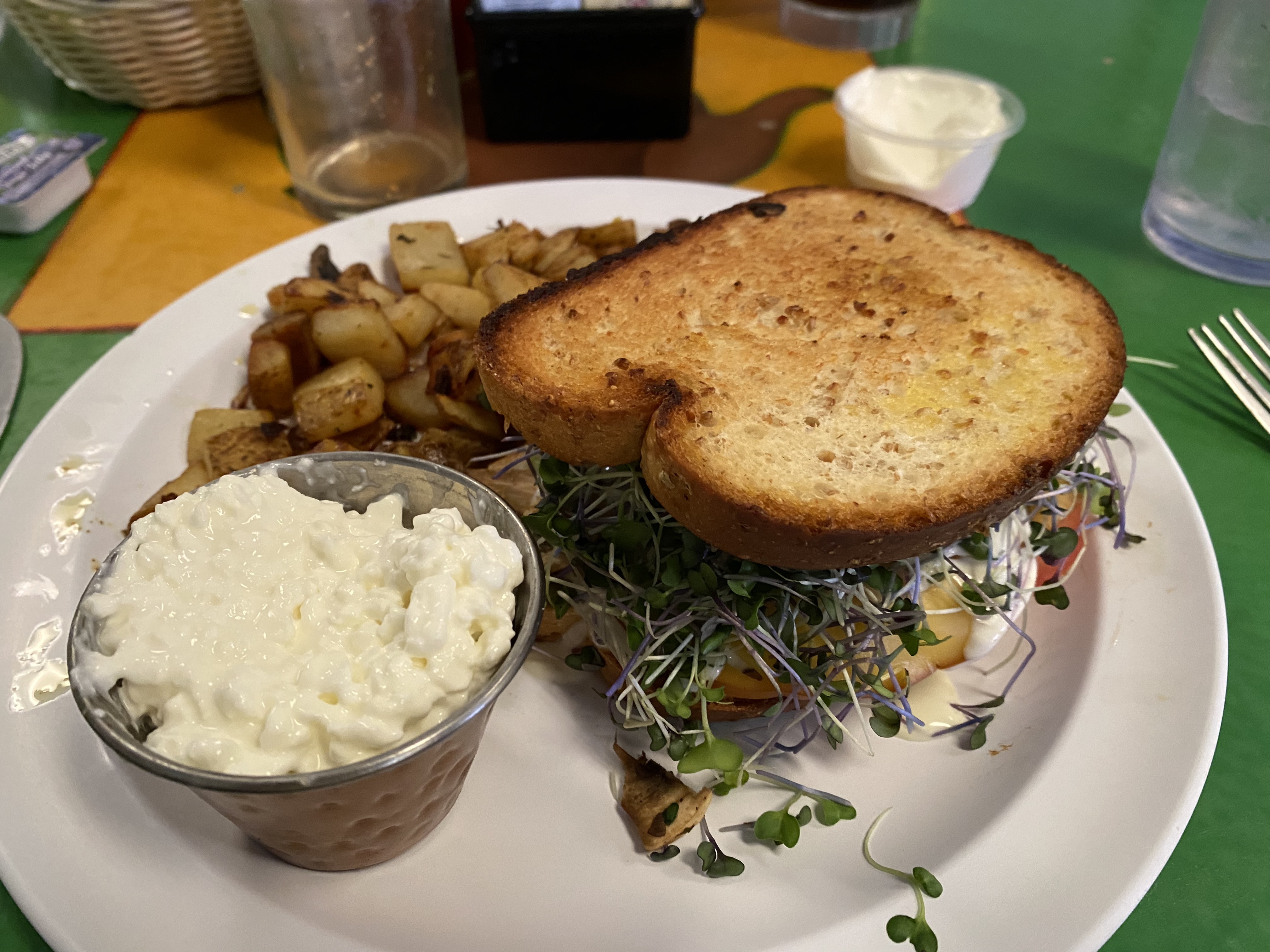


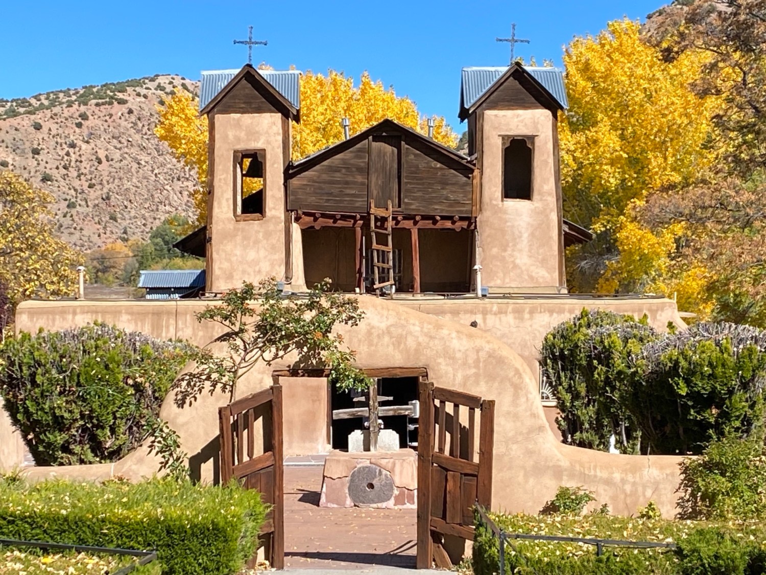


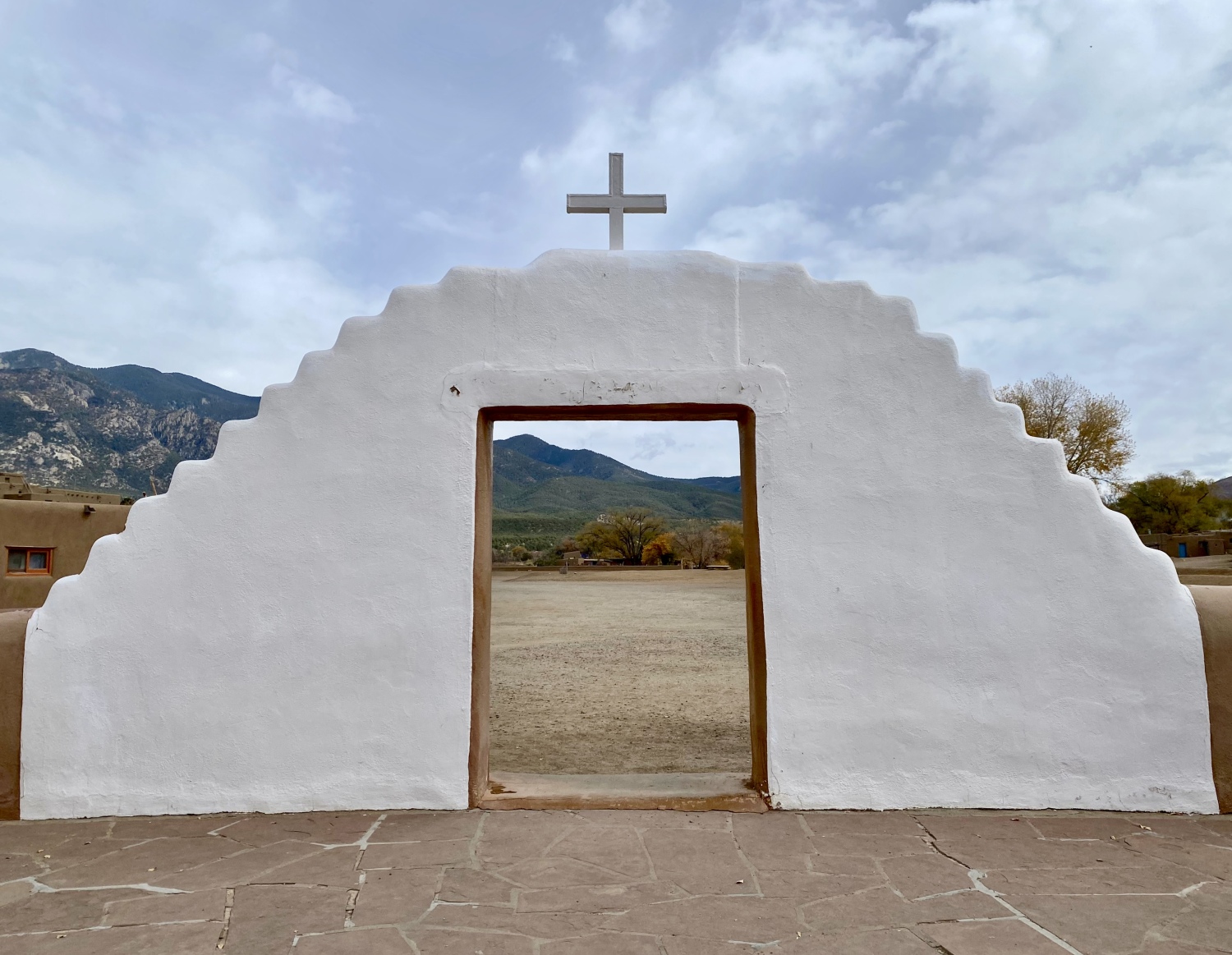


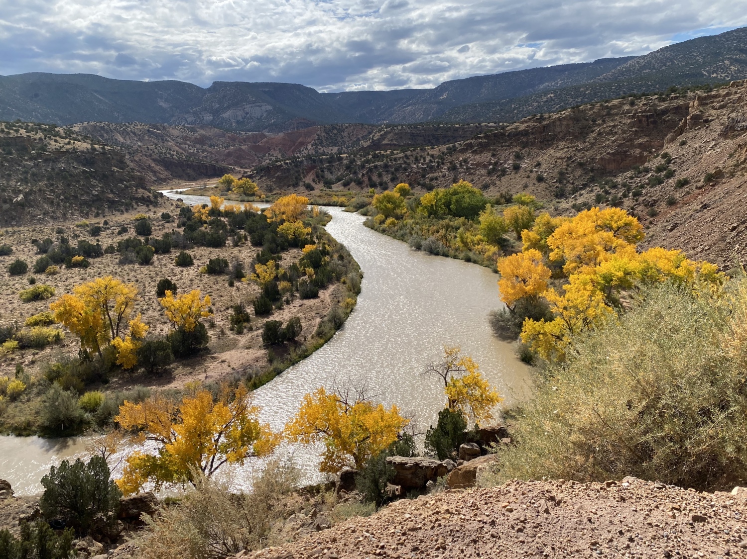


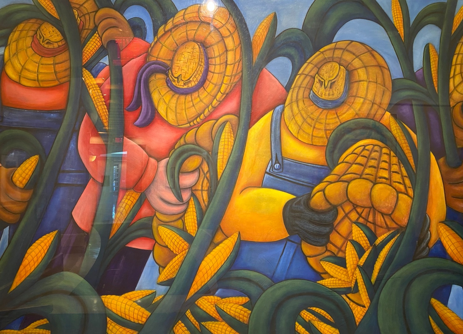


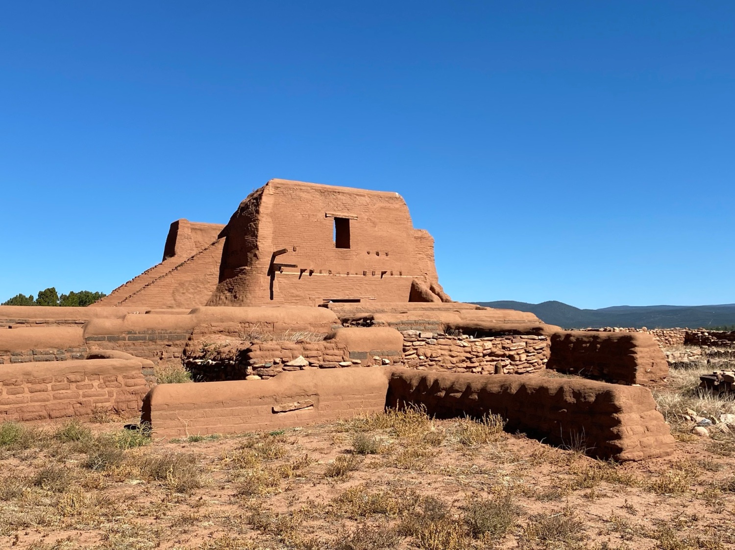


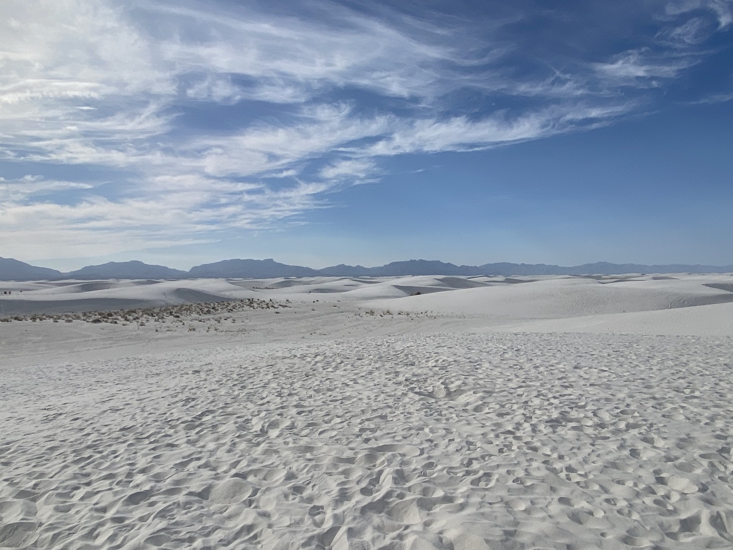
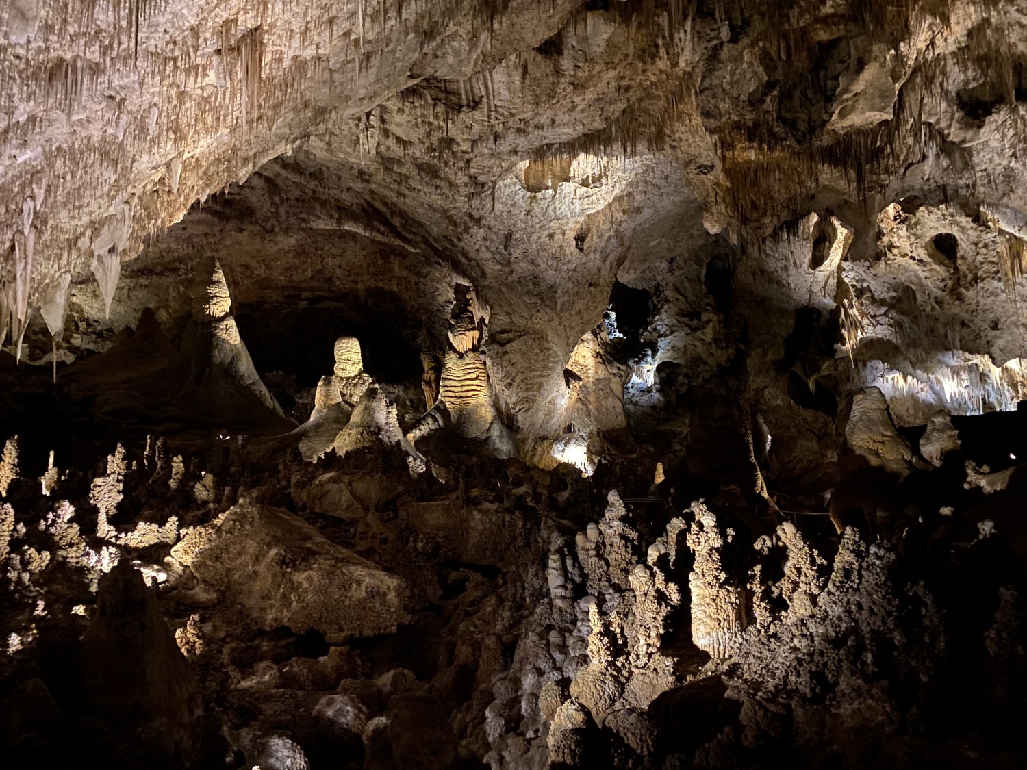


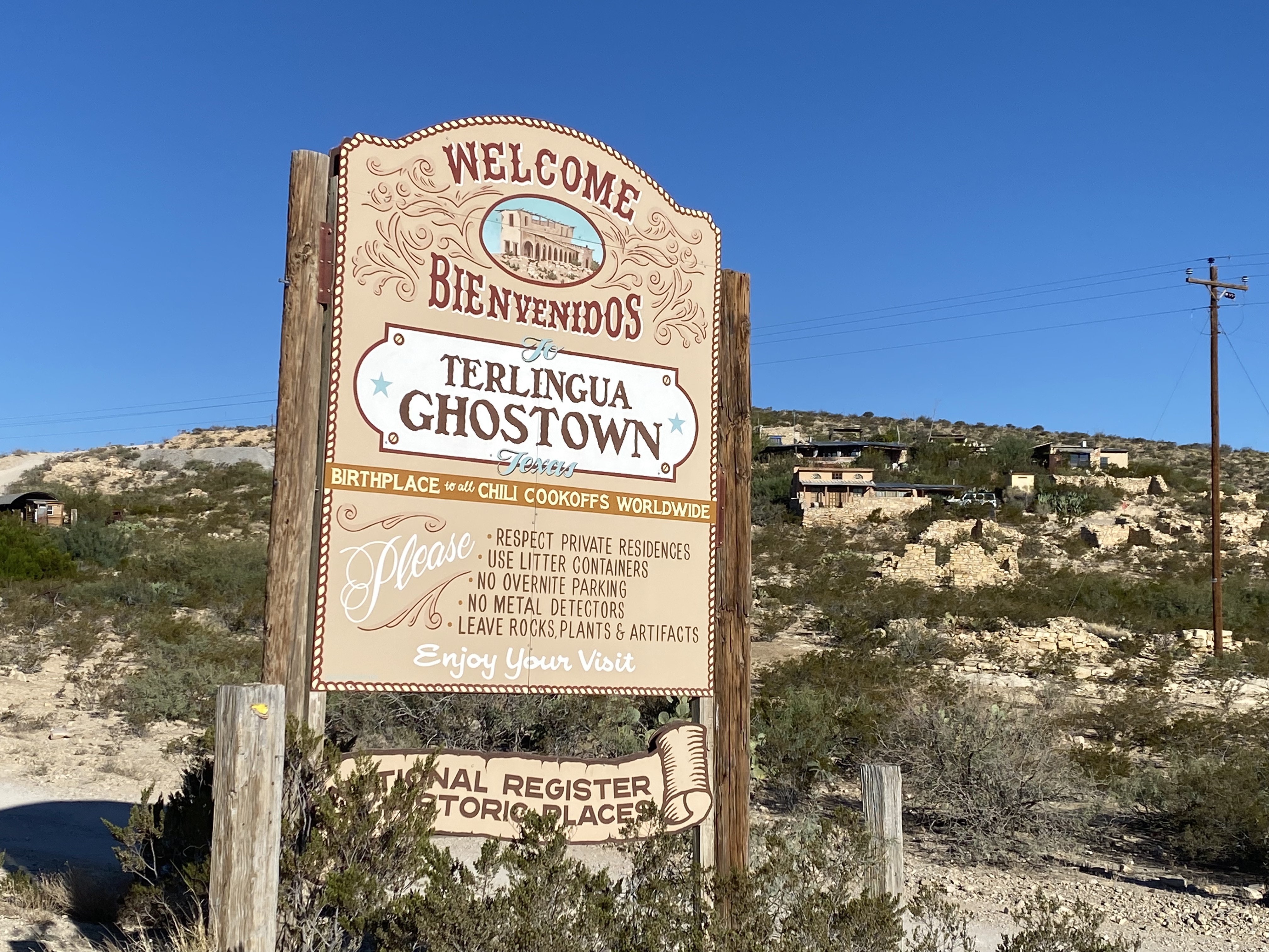


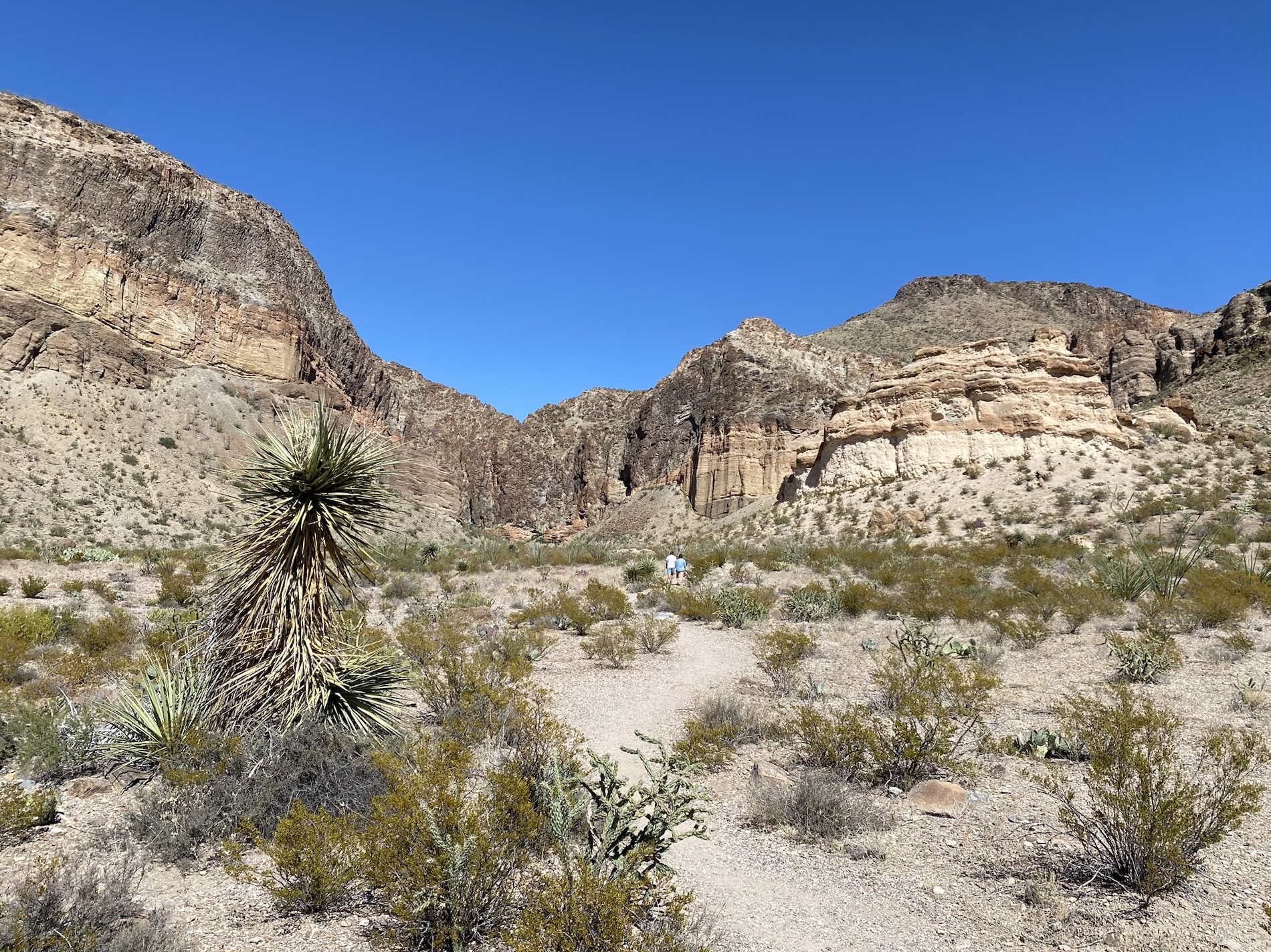


You must be logged in to post a comment.