
We left Aït Ben Haddou at 8:30 and stopped for pictures of the town from afar. After a quick selfie with Chai, the Thai pediatrician who kept insisting I was his photography teacher(!), we were on our way to a mountain gîte in the High Atlas Mountains.


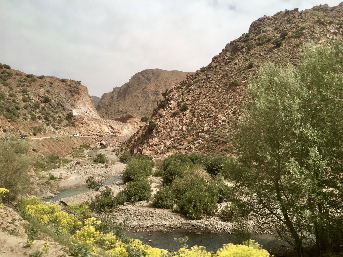
We were immediately winding along mountain roads. Green fields were dotted with bright red asterisks of poppies and needles of prickly pear cacti. We bumped over dirt roads for a long while. Red mudbrick ruins and cottonwoods lined a stream in the valley. The landscape was full of broom, apple orchards, olive groves, onion fields and mustard plants or linseed.
I bought a small alabaster dromedary at a rest stop close to 10:00. Soon after we went through the pass of Tizi-n-Tichka, 2,260 meters high, the highest point of our journey. We were heading toward Toubkal National Park.


At 10:30, we stopped for pictures over dry brown mountains and a green valley. Then it was a long curvaceous drive over the High Atlas Mountains. Road construction was everywhere, bumpy gravely roads, construction debris, red dirt and dust flying everywhere. We passed pottery and mineral vendors.

a green valley set in brown mountains

High Atlas Mountains

High Atlas Mountains

High Atlas Mountains

High Atlas Mountains
High Atlas Mountains
High Atlas Mountains

High Atlas Mountains
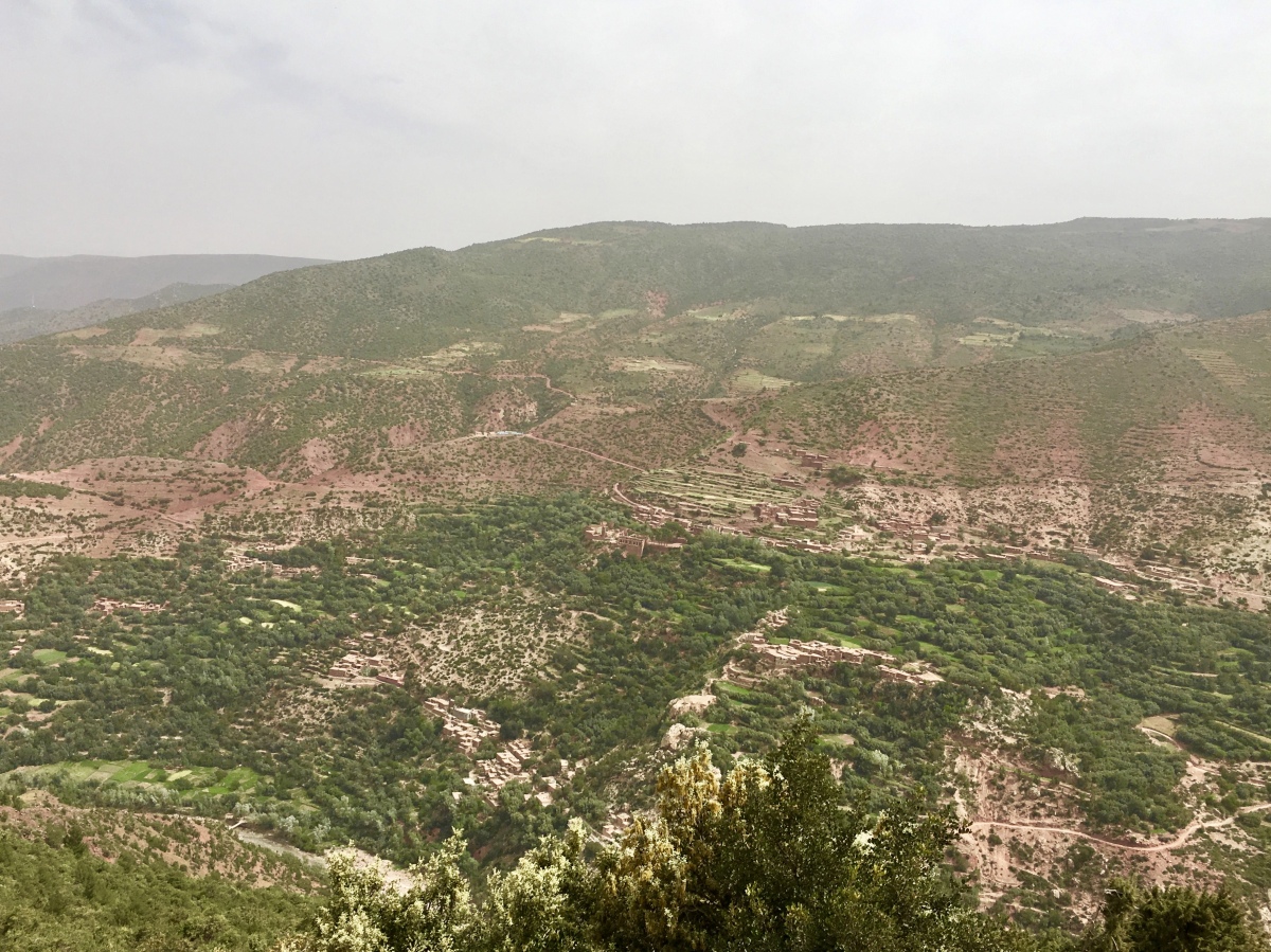
At a noon bathroom break, I bought some postcards and bookmarks. We had a grand view north into the valley to the east of Marrakesch.


At 12:30, we stopped at a Pharmacie for many in our group who had caught colds, but the line was too long.
Then we were in a flatter area, still green, but a dusty green. Shepherds wearing straw hats and vests herded their sheep. We passed groups of brightly clad and mismatched people standing along the road as if waiting for a bus.

flat area east of Marrakesh
We stopped after 1:00 at another Pharmacie. There I bought two pens because my pens were running low on ink.
We drove around the outskirts of Marrakesh and then south on R203 toward Toubkal Parc National, North Africa’s highest mountain range, known by local Berbers as “Idraren Draren” (Mountain of Mountains). It towers above the Haouz plain, dividing it from the Sahara. The High Atlas runs diagonally across Morocco for almost 1,000 km, but the Toubkal region contains the best peaks. The first roads cut through this region were in the early 20th century. Before that, there were only mule trails leading from the Sahara to the northern plains. The highest mountain in North Africa is the snow-capped Jebel Toubkal.
We wound along steep mountain roads higher and higher, with linseed, rocks and streams in the valley, and the snow-covered High Atlas before us. We stopped to eat at a restaurant where I ordered an avocado with shrimp salad and mango juice. The waiter was terribly disorganized and our meals came out piecemeal. It was a super long and frustrating wait; we were there for 1 1/2 hours. I hate such incompetence and hate waiting around for such a long time when I just want to get to our destination. Of course, Susan was always sympathetic to this: “Oh, he’s so overworked, poor guy.” I, on the other hand, feel that when I’m paying for something, there should be a certain level of competence. I hate wasting so much time sitting around at interminable lunches.


from the restaurant to Imlil
By 4:00, we’d arrived at Imlil (elevation 1,740m), the launching point for trekkers into the High Atlas. We loaded our bags onto the donkeys, and then hiked uphill to the neighboring Aroumd (aka Armed or Armoud) at 1,960m. We passed a burbling stream, stone houses, a mosque, and shady apple orchards. We crossed wet creek beds, streams and some gravelly terrain. Many of the group went ahead quickly and left the slower of us behind. Aziz got irritated that the group was so spread out and wasn’t keeping together as a team. Several times, we lost sight of those ahead and had no idea at forks in the path where to go.
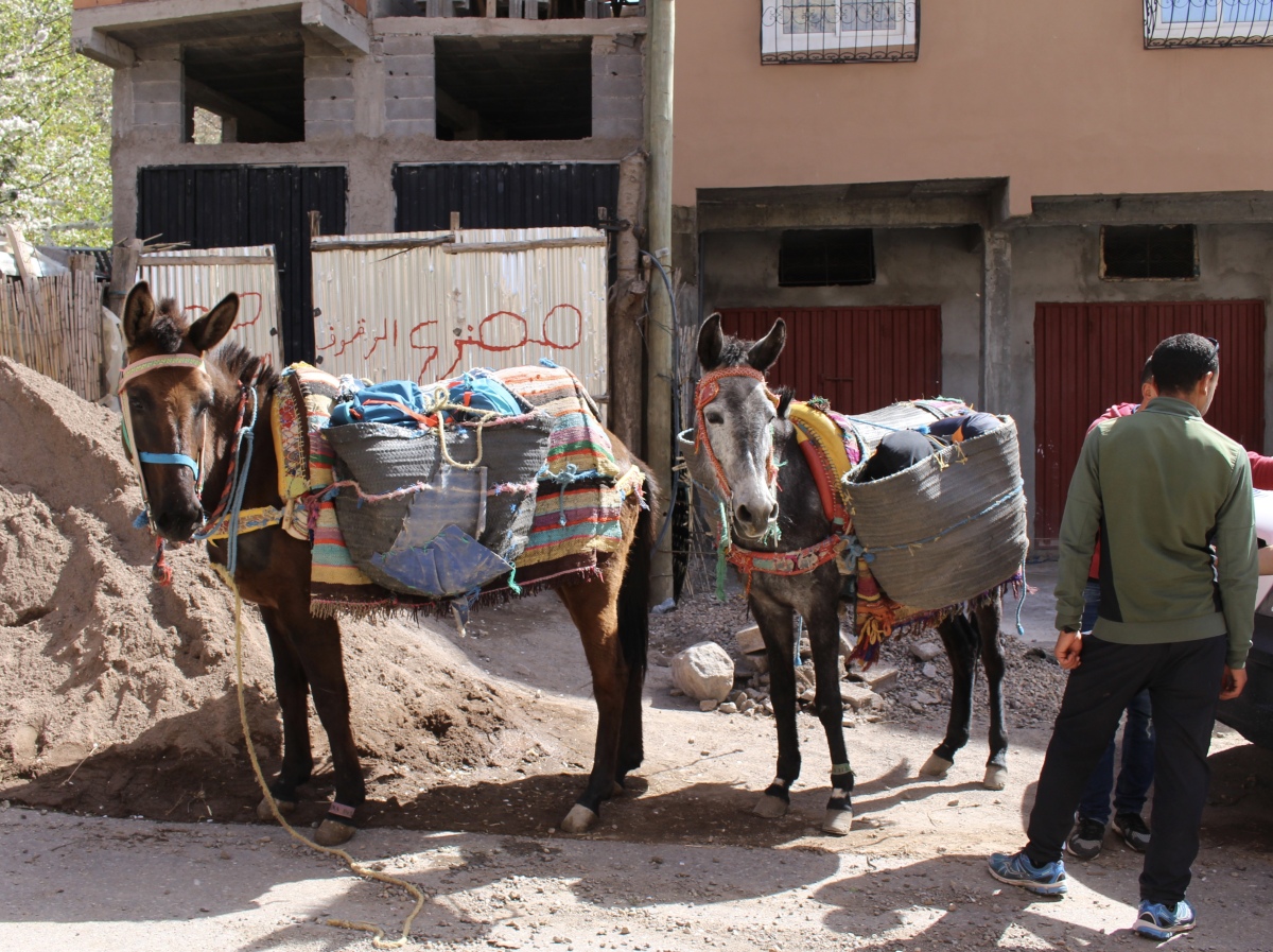
loading the donkeys

loading the donkeys

loading the donkeys

Imlil to Aroumd

Imlil to Aroumd

Imlil to Aroumd

Imlil to Aroumd

Father Anthony brings up the rear

snow covered High Atlas Mountains

Imlil to Aroumd

Imlil to Aroumd

Imlil to Aroumd

Imlil to Aroumd

Imlil to Aroumd

orchards

orchards

the donkeys climbing


I found a nice collection of doors along the way. They reminded me of Omani doors.


arrival in Aroumd
We finally arrived at Auberge Ifrane a Imlil Marrakech, run by Azizi Lacha. We had to redistribute ourselves in rooms: Susan and I shared with Tammy. We sat on the terrace and had mint tea and fresh popped popcorn.


From the balcony, we had a view of the mountains. Aroumd is tucked into the folds of the High Atlas in the Ait Mizane Valley. Jbel Adj and Jbel Agelzim are two peaks that tower overhead in their snow-covered glory. The air was fresh, clear and cool, and it was pleasant to be so far from civilization and traffic.

view of the snow-covered High Atlas from Auberge Ifrane a Imlil Marrakech
I went out to take a walk through the village and Yulian (nicknamed Nana) asked if she could come along. Natalie also joined. We climbed to the top of the village for views into the valley from where we’d started our hike. We kept trying to remember all the turns we took so we’d be able to find our way back: “take a left between 64 & 65 at the green door,” etc.


We took turns posing for pictures near the top of the town and saw the mountains all around as well as the valley below.


We found a poor little kid (goat) with deformed front legs. Natalie picked some greens and fed them to it.

Natalie feeds the deformed goat
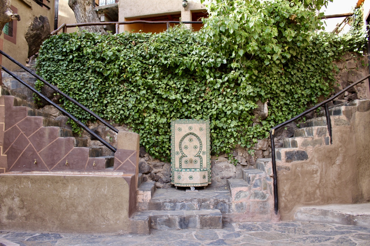
We walked back downhill by the gardens and a falaj (watercourse). Natalie and Yulian continued to walk along the falaj, while I walked uphill to a charming house. A man and woman sitting on the terrace told me a different way I should walk as I was encroaching on their private home.

gardens near falaj in Aroumd

me in Aroumd

village of Aroumd

gardens in Aroumd
private home in Aroumd

gardens in Aroumd
On the way back to the auberge, cheeky little kids kept making finger gestures at me, but I had no idea what they meant. When I said “Salaam u alaykum,” they repeated it to me in a mocking way. Natalie said when she walked past a little girl, they said hello to one another, but once she’d walked past, she thought the girl said “F*#k” with a smile. I said maybe the girl was saying the Arabic فـقــد (faqad) or “lost.” I had remembered learning that word when I studied Arabic and thinking how it sounded like our expression of profanity.


Dinner was communal with couscous and veggies (always overcooked) and roasted chicken and the same old Moroccan soup. We had orange quarters for dessert. There didn’t seem to be much variety in the Moroccan diet. It was just okay.
The most fun we had was playing a game Gabriel had on his phone, a kind of game where an animal name showed up on the phone and we had to get him to guess it. Later, we played another version using actions: “picking apples,” “bungee-jumping,” “ventriloquist,” that we acted out to get a person to guess. It was hilarious! We were all laughing our heads off. One answer was “South Africa,” and I said “Hey mon.” Gabe said, “That’s Jamaica!” and we couldn’t stop laughing. It was a boisterous and crazy time and it was fun because it included everyone in the group and wasn’t cliquish.
Everyone badmouthed poor Father Anthony, and Natalie was supposed to share a room with him in our tight communal quarters, but in protest, she slept in the common area. It got rather cold in the mountains at night, but we all bundled up in our fuzzy blankets and managed to make it through the night.
*Steps: 12,568, or 5.33 miles*
*Wednesday, April 17, 2019*
**********************
“PROSE” INVITATION: I invite you to write up to a post on your own blog about a recently visited particular destination (not journeys in general). Concentrate on any intention you set for your prose.
One of my intentions was to write about how I revel in (or resist) the experience. Do I bask in the light, the breeze, the rustling of leaves on the trees? Do I linger over cuisine and wine? Truly possessing a scene is making a conscious effort to observe closely.
It doesn’t matter whether you write fiction or non-fiction for this invitation. You can either set your own writing intentions, or use one of the prompts I’ve listed on this page: writing prompts: prose. You can also include photos, of course.
Include the link in the comments below by Monday, April 13 at 1:00 p.m. EST. When I write my post in response to this invitation on Tuesday, April 14, I’ll include your links in that post.
This will be an ongoing invitation. Feel free to jump in at any time. 🙂
I hope you’ll join in our community. I look forward to reading your posts!

The mountains look amazing, so high and rugged. Lovely photos again, Cathy.
LikeLike
Thanks so much, Carol. It reminded me so much of Oman. 🙂
LikeLiked by 1 person
It felt like a long trek to get there, Cathy, but I loved your little sanctuary in the mountains. 🙂 🙂 I expect you still have plenty of writing to do. Still managing to get out for a walk each day?
LikeLike
It was one of the more fun days we had on the trip, Jo, especially with the games at night. I love playing games, and I like a group when they’re not formed into small cliques. I have stopped walking for a bit because I’ve had congestion (no fever or cough) since March 5, and it seems to get worse when I go outside. I think it’s allergies, but who knows. I can’t seem to shake it. So I’m staying in until it starts to clear up. 🙂
LikeLike
Doesn’t sound pleasant, Cathy. Unless it’s cold and wet I don’t like staying indoors. Our roof terrace is worth it’s weight in gold right now. Hope it clears soon. 🤗💕
LikeLike
It’s not pleasant to have all this congestion, with on top of it worrying if I may have coronavirus. Luckily I’ve heard of others with the same symptoms and I will continue to believe it’s allergies unless I’m tested and told otherwise. I don’t intend to be tested but just to stay at home unless my symptoms change, which they haven’t since March 5.
I don’t like staying indoors either, but today it’s rainy, cold and gloomy. We had an 80 degree day last week that really perked me up. But it seems we’re back into the throes of winter at this moment. I bet you LOVE that roof terrace. I would be loving my screened-in porch if it weren’t so cold. Thanks for the good wishes. 🙂
LikeLike
🤗💕
LikeLiked by 1 person
Magnificent mountains. You have captured them well in your photos Cathy. How steep was that walk?
LikeLike
Thanks, Pauline. The walk was a bit steep in parts but not that steep that it was miserable the whole way. 🙂
LikeLiked by 1 person
While the high places must have been impressive, the bright colors draw me, probably enhanced in the quality of your photographs. The painted doors, the donkey riders, woven blankets, not to mention flowers. The goat breaks my heart.
LikeLike
I am a big fan of bright colors too, Christopher. I loved the doors especially since they reminded me fondly of my times in Oman. That goat was very sweet, and sad.
LikeLike
I loved the patches of colour in among the brown mountains which could have looked very depressing without the occasional splash of vividness. Not sure if I would have enjoyed that trip – even in your company – and I do admire your tolerance in giving the benefit of the doubt to the pronunciation of the Arabic/rude word. Let’s face it, we are not really welcome in some areas now so we have to expect a certain degree of coolness towards us, or even rudeness.
LikeLike
Thanks, Mari. I liked the splashes of color too. I’m always drawn to color in any landscape. We did encounter more rudeness later, and I know we’re certainly not welcome in many places, but coming from children, it really took me by surprise. Oh well, who knows if the girl meant any harm at all. We had several very ugly encounters in Marrakesh!
LikeLike
The place you stayed looked lovely – not sure I would have cared for the reorganised sleeping arrangements though! The group still sounds problematic, and I hate games so I’d have probably been the annoying party pooper that night.
LikeLike
Oh well, about the games, not everyone played, but at least the ones who did enjoyed the time as a larger group. We had a lot of laughs. I love games, so that cheered me up a lot. 🙂
LikeLiked by 1 person