
Sunday, October 15, 2023: It was a monotonous 6-hour drive from Fredericksburg, TX through a flat endless landscape to Big Bend National Park in the southwest part of Texas that abuts the Mexican border.
Big Bend is home to the 8,000 feet tall Chisos Mountains, the only U.S. mountain range contained entirely within the boundaries of a single national park. From its riverfront terrain to vast Chihuahuan Desert landscapes and the cooler summits atop the forested Chisos Mountains, the park boasts biodiversity, scenery and recreational offerings. It borders the Rio Grande River, which marks the U.S.-Mexico border. Established on June 12, 1944, its current acreage is 741,118. It was designated a Biosphere Reserve in 1976.
We moved into Chisos Mountains Lodge, the only accommodation within the park’s borders other than campgrounds. We had reserved this place a year in advance, as people are advised to do. We cheered each other on our safe arrival with vodka tonics and Okra Snax on our balcony then had dinner at the Chisos Mountains Lodge Restaurant. Mike enjoyed Chili de la Casa (Texas-Style chili with beef and smoked chorizo) and I enjoyed Headwaters Harvest: baked rainbow trout, orange beurre-blanc, cilantro rice and asparagus. We also shared a cherry cobbler, absent the “a la mode” as they were out of ice cream.


Steps: 9,135; Miles 3.87. Drove 443.8 miles. Weather Hi 72°, Low 47°.
Monday, October 16: After eating a breakfast of yogurt, granola and strawberries in our room, we started our first day at Big Bend National Park by going to the Visitor Center to get some hiking advice and to get my National Park Passport stamps.
We then took the 0.3 mile Window View Trail near the Basin store. We saw the mountains draped in morning shadows and dotted with an abundance of prickly pear and other cacti.


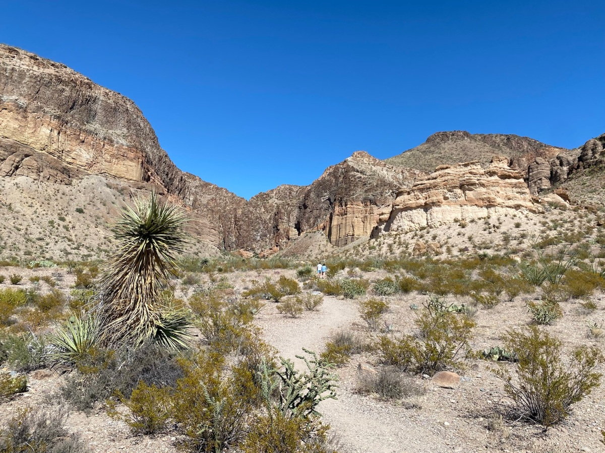
We then drove to the campground and started the Window Trail at campsite #51. This was a 4.8 mile moderate-level round trip hike where the first half was all descents and the second half was all ascents, although gradual. The trail descended to the Window Pour Off, an abrupt 200-foot drop-off. The scenery was spectacular with yellow flowers, all kinds of cacti, and great views of the Chisos Mountains. The weather was cool to start, with lovely breezes and even some shade on the descent. I loved walking through the narrow, steep-walled canyon to get to the end. The Park Service had carved steps into the rock at spots so hikers could avoid some of the more difficult rock scrambles. The view at The Window was fabulous; there we stopped to rest and eat some snacks. The whole hike took us about 3 hours and 20 minutes, with numerous stops for pictures, snacks and lunch.


After finishing the Window trail, we went to the Basin Store and bought sodas and candy bars, a mug for me, and plastic cups to use in our room. After relaxing a bit, we drove over an hour on the Ross Maxwell Scenic Drive, stopping for views at Sotol Vista. The viewpoint looks toward Mexico, the Rio Grande and Santa Elena Canyon, the destination of the scenic drive.
The spear-like plant at the overlook is sotol, a member of the lily family. For thousands of years, Big Bend’s early inhabitants roasted the heart of sotol for food and used the leaf fibers for rope and sandals.


We also stopped at the Lower Burro Mesa Pouroff. Burro Mesa hints of Big Bend’s volcanic past, with its yellow and orange bands across the bluffs. They are ash-flow tuffs, which show the layered beds as they were deposited. Pouroffs are seasonal waterfalls. During rainy times, water flows through the drainages in powerful flash floods, continuing to carve the channel.
Lower Burro Mesa Pouroff
At Santa Elena Canyon, a short trail enters the mouth of the gorge, where limestone walls tower 1,500 feet above the Río Grande. The trail crosses Terlingua Creek, which is usually dry, and gradually climbs to an overlook before dipping to the river bank. The trail has some steep steps and can be very hot midday.
Like liquid sandpaper, the swift current of the Río Grande files away at Santa Elena’s hard limestone, cutting it deeper. The canyon is 8 miles (13km) long and 1,500 feet (450 meters) deep. In some places the canyon is only 30 feet (9 meters) wide at the bottom.
We walked the Santa Elena Canyon Trail but I was misled as to its difficulty. The woman at Castolon told us it was easy enough to walk in Tevas. Since it was so “easy,” I didn’t bother taking my hiking poles either. We had to climb a steep sandy bank to begin the trail from the creek bed, which was all dried and cracked. There were many paved switchbacks for an 80-foot climb and then we were walking along the gravelly canyon trail with a steep drop off to the river on one side. Though the trail map said it was 1.6 miles round trip, it was longer. It was getting quite hot and I hadn’t brought my water bladder, though I had a water container in my pack, which I had to keep stopping to take out. I finally turned around in frustration with the whole thing. Mike went ahead but caught up with me on the way back. He helped me climb back down the sandy bank by trying to hold my feet in place from below; I yelled at him to let go of my feet! I would have preferred to slide down on my butt, but I was frankly too terrified to do either. Finally, we made it down, but I was not happy with the whole affair! I was covered in dust and couldn’t wait to get back to the lodge to wash off the whole miserable experience.


On our way back from Santa Elena Canyon, we stopped at the Mule Ears Viewpoint, but we didn’t take the trail there.


Our Monday in Big Bend came to an end as we returned to the lodge, showered and enjoyed vodka tonics on the deck off our room. As if that wasn’t enough, I had “The Window” at Chisos Lodge Restaurant (Woodford Whiskey Smash, layered in mint, cactus fruit and a hint of lime), while Mike had a shot of tequila. For dinner we shared a roasted red pepper soup with Gouda. Mike had the black bean burger and I had delicious Southwest Style Eggrolls: chicken, corn, black beans and avocado. We shared a fudge brownie a la mode. Yum!
We enjoyed the last bits of sunset, the Milky Way and the starry sky.


Steps: 21,416; Miles 9.08. Drove 100 miles. Weather: Hi 80°, Lo 52°.
Tuesday, October 17: Mike got up early Tuesday morning and hiked the Lost Mine Trail, while I slept in and relaxed in the room. He finally got to see his black bear while he was hiking, so I’m glad I didn’t go. The last thing I ever want to encounter on a hike is a bear, a mountain lion, or a rattlesnake!


When he returned we hiked the Chisos Basin Loop Trail. It was a lot of climbing, about a 1.9 mile loop, with decent but not spectacular views.


After having lunch in our room, we drove to the easternmost side of the park, ending in Boquillas Canyon. From the Boquillas Overlook we saw the village of Boquillas, Mexico just across the Rio Grande.


We stopped at the Río Grande Overlook and saw some of the plants native to the area.


We stopped at Río Grande Village briefly and then drove the two-mile gravel Hot Springs Road that descends down a rough, narrow wash to the Hot Springs Historic District and trailhead area. From the trailhead, the hot spring is a 0.5 mile round trip.
On our way to the springs, we saw the remnants of the old lodge built to draw visitors in the early 1900s.
The springs were developed by J.O. Langford beginning in 1909. The site was the first major tourist attraction in the area, predating the national park. Langford built an adobe house, a stone bathhouse, and brushwood bathing shelters. The Langfords left in 1912 when bandits made the area unsafe. When they returned in 1927 they rebuilt the bathhouse, but with a canvas roof. They also built a store and a motor court, consisting of seven attached cabins.
Today, all that remains of Langford’s tourist destination are ruins, but the springs themselves are still a draw for park visitors.


On our walk to the hot springs, we checked out the rock art left behind on the limestone cliffs.


We soaked in the hot springs but, since it was so hot outside, we floated a bit in the cooler Río Grande. The hot spring water is heated by geothermal processes and emerges at 105° F.; the water carries dissolved mineral salts reputed to have healing powers.


After returning to the lodge and showering off the mud from our hot springs excursion, we walked to the Chisos Lodge Restaurant where we found quite a line to get in. We decided to order take out from the bar and sit on the patio overlooking Chisos Basin. I had a Blackened Salmon BLT and Mike had a Bandito Burger and while we ate, we shivered and watched the sun going down.
After dinner we took a walk around the Window View Trail in the blue light.


Here is a short video of our time in Big Bend.
Steps: 13,526; Miles 5.73. Drove 73.8 miles. Weather Hi 87°, Lo 56°.


You must be logged in to post a comment.