Saturday, June 24: As we were leaving Cinque Torri, we found on our GPS that the Great Dolomites Road was closed at the pass, so we had to reroute and couldn’t take our scenic route to Bolzano. We ended up backtracking all the way to Cortina d’Ampezzo and to Dobbiaco and Brunico and then eventually toward Bolzano on the A12 autostrada.
The Renon Plateau: Kinig Farm
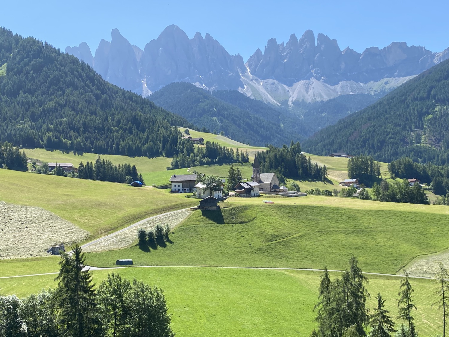
Just before Bolzano we were instructed to take a windy road up and up a very steep mountain. It felt very perilous! There were many steep drop-offs and the road eventually narrowed to just over one lane wide. Switchback after switchback led us eventually to the “town” of Signato on the Renon plateau and to a farm called Kinig, where Werner (the father of the Airbnb host Franz Maria) greeted us. We had reserved an apartment on this high mountain farm for 4 nights. It was a charming little place!


Soprabolzano/Oberbozen
Luckily, though the road ended at a gate, we were given a pass to open the gate so we could drive a few kilometers further up to the town of Soprabolzano/Oberbozen. Neither of us were thrilled about having to drive that winding road back down the mountain to go to dinner or get groceries in Bolzano, so that gate-opening card was truly the magic ticket. We were also given a free gondola card which we could use for the gondola down to Bolzano.
After checking into our farmhouse Airbnb apartment, we drove up the mountain to Soprabolzano. Here we stocked up on groceries for our 4 night stay in Renon, then we went to eat dinner at the lively and friendly Gasthaus Babsi, recommended by the friendly check-out lady at the supermarket. It was a cool place with a friendly staff and old American tunes playing. We shared a Rucola and Brie pizza and I had the most delightful drink called a Hugo that had Prosecco, lime, fresh mint, seltzer, and elderberry liqueur. Mike had an Estivo: white wine, soda and lemon.For dessert we shared a buckwheat cake with lingonberry jam and whipped cream. Before we left the place, the bartender gave us each complimentary limoncellos.
We took an after-dinner stroll on the lower edge of the town, where we saw beautiful views of the jagged Dolomites against a foreground of alpine meadow. The town also had a community swimming pool which we had access to. From the town, there was a large cable car 🚠 that went down into the valley to the city of Bolzano. We planned to take that down one day to avoid the harrowing drive up to our farmhouse apartment.
We admired the charming Parrocchia Maria Assunta di Soprabolzano with its fetching onion dome in the waning sunlight.


Steps: 12,253; Miles 5.19. High 77°, Low 52°. Sunny.
Val di Funes: the Panoramaweg & Sunnseitnweg Circuit Hike
Sunday, June 25: On Sunday morning, we drove about an hour from Renon to Val di Funes to hike the Panorama Trail (“Panoramaweg” in German) and the Sunny-side Trail (“Sunnseitnweg”), which when linked together creates an easy, scenic circuit hike.
We started in Santa Maddalena/ St. Magdalena, a village in Val di Funes (Villnösstal) in South Tyrol. This small mountain village is home to the historic Santa Maddalena Church, which is one of the most popular photo spots in the region. The church dedicated to Santa Magdalena is located where pagan rituals once took place. The first building was mentioned in 1394 documents; today only the church tower remains of that original church. The interior has Baroque elements. The altar features a contrite St. Magdalena, patron saint of the church. Next to her are sculptures of St. Peter, John the Baptist, John the Evangelist and Jerome.
The Santa Maddalena Panorama trail led us through meadows, pockets of forest, and historic Tyrolean farmsteads along narrow footpaths as well as low-trafficked paved roads.
We enjoyed grand views of the Odle/Geisler Peaks, which form the dramatic backdrop of Santa Maddalena Church and the tidy farmhouses set in the lovely green valley.


After our hike, which was about 4.5 miles and took us about 3 hours of leisurely walking, we visited the tiny and picturesque onion-steepled Chiesetta di San Giovanni/ St. Johann Church nearby. It is one of the Dolomites’ most iconic photo-ops. The small Baroque church, founded by Michael von Jenner and built in 1744, sits alone in a meadow, part of the Ranuihof Farm, below the spiky peaks of the Odle mountain group. We paid to park plus a 4€ entrance fee to visit. Because of the way it was blocked off and because of the entrance fee, it felt a bit too staged for us.


Sunday evening after our hike at Val di Funes, we returned to our farmhouse Airbnb and enjoyed wine, bread and cheese at a picnic table in the shade. We made an asparagus and cheese pappardelle that was quite delicious. We spent the evening relaxing in our charming apartment.


Steps: 13,119; Miles: 5.56. High 83°, Low 55°. Sunny.
Bolzano/Bozen
Monday, June 26: Monday morning we took the cable car 🚠 (a 12-minute ride) from Soprabolzano, not far from our farmhouse, to Bolzano down in the valley.


Bolzano/Bozen is the capital city of the province of South Tyrol. With a population of 108,245, Bolzano is also by far the largest city in South Tyrol. In the 2020 version of the annual ranking of quality of life in Italian cities, Bolzano was ranked joint first for quality of life alongside Bologna.
Bolzano is considered a bridge between Northern Europe and Southern Europe due to the three spoken languages in South Tyrol (Italian, German, and Ladin) and the confluence of Italian and German-Austrian culture.
Being located at multiple climate borders, Bolzano features a humid subtropical climate with hot summers and very cold winters by Italian standards.Because of its low altitude in a valley south of the main alps, Bolzano is sheltered from cool winds during daytime, ensuring much warmer temperatures year-round than in similar valley cities north of the range. It was in the mid-90s on the day we went down while it was in the low 80s on the Renon plateau.
We enjoyed wandering around the town. We walked around Waltherplatz, the main square in Bolzano. Walther von der Vogelweide, the square’s namesake, towers as a white statue in the middle of the square. We stopped at a favorite store we keep running into in various Italian towns, OVS. Mike was looking for some t-shirts and shorts and I bought a dress 👗. 😂
We had a lovely lunch in a shady and breezy alley. I had a burrata and tomato salad that was super refreshing. Mike had a tuna salad. As always in Italian towns, we love to watch the fashionable people strolling by. After lunch, we happened upon a lively flower market.
After strolling around a bit more, we made our way to the cable car and took it back up the mountain to Renon.


The Renon/Ritten Plateau
After Bolzano, we spent the rest of our day on the Renon/Ritten Plateau, home to our farmhouse apartment. We drove to the town of Collalbo/Klobenstein and wandered around. Not much was happening there as it was in the heat of the afternoon, so we settled inside the only cafe in town to enjoy a very skimpy serving of gelato 🍧. It was refreshing but not quite enough to sooth our souls.


We reached the peak at Rittner Horn, at an altitude of 2260 meters, by taking the gondola from Pemmern/Tre Vie to Schwarzseepitze. From there it’s about an hour hike up to the top, but we didn’t take the hike. We could see excellent views of the mountains all around.


After our day taking the cable car to Bolzano and exploring some of the Renon/Ritten plateau, we stayed at the farmhouse and cooked some Bratwurst and some leftover pasta with zucchini. It was nice to spend a slower day simply enjoying our home town area.

dinner in the farmhouse
Steps: 11, 706; Miles 4.96. High 97°, Low 64°. Sunny.
The High Alpine hikes of Alpe di Siusi
Tuesday, June 27: With a size of 56 square kilometers, the Alpe di Siusi in South Tyrol is the largest high alpine pasture in Europe. On Tuesday, we drove about an hour from Renon to Ortesei/St. Ulrich where we took the Mont Sëuc cable car to the alpine meadow. There we spent much of the day, about 5 1/2 hours, hiking all over the meadow, about 6 1/2 miles.
We started by following Trail 9 to Saltria, which was a long slow descent. We passed alongside pastures of grazing horses and sprawling fields of colorful wildflowers. Many people posed amidst the wildflowers for pictures.
Saltria is a small village on Alpe di Siusi, located at an elevation of 1675 meters. It’s also the lowest point of the plateau. We had amazing views of the Catinaccio/Rosengarten range as we descended. We stopped at a hotel in Saltria for a cappuccino and an apple strudel.
As we crossed the rolling Alpe di Siusi meadows, Sassolungo and Sasso Piatto dominated the view to the southeast and the Catinaccio and Sciliar mountains dominated the views directly south and to the southwest. To the north, views extend to Monte Pic, Seceda, and the Geisler Group.
Of course what goes down must come up, so we hiked a long uphill out of the valley through the Römer mountain pasture, where cattle grazed freely.


We headed toward Compaccio but stopped for a restroom break at Rauchhütte before venturing back to our starting point. We originally intended to go to the town of Compaccio but decided not to go all the way into town.
We made another stop, this time at Sanon Hütte/Baita Sanon where Mike had a beer and I had my new favorite drink, a Hugo (Prosecco, mint and elderflower liqueur). Yum.
After we left the hut we enjoyed more beautiful views of the mountains. Looking north, we saw Monte Pic, the Geisler Peaks, Monte Stevia, Piz Duleda, and Col dala Pieres.
We had paid the extra 5 euros for the gondola from Sole Lake back up to the Mont Sëuc cable car, and we were happy we did as it saved us a long uphill slog at the end. What a gorgeous hike!


Ortesei/St. Ulrich
After our hike at Alpe di Siusi, we took a short wander around the town of Ortesei/St. Ulrich. This is in Val Gardena where many people stay when they come to the Dolomites. The town looked appealing, but we were happy with our little mountain farmhouse in Renon.


Soprabolzano
After we relaxed a bit at our farmhouse apartment, we drove up to Soprabolzano where we had a lovely dinner on the terrace of The Post Hotel overlooking the valley and the cable car. We had intended to go to Gasthaus Babsi again, but it was closed on Tuesdays. We shared Rinderbouillon mit Kräuterfrittaten, a delicious soup with tiny strips of pancake in it. Mike had Hacksteak vomeinheimischen Lamm auf roten Zwiebeln und Röstinchen, a delicious lamb loaf with a potato pancake and red onions; I had Spinatspätzle mit Entenragout, spinach spaetzle with duck ragout.
After dinner we strolled briefly around the town. This would be the last time we’d see our cute little town above the farmhouse.


Steps: 22,819; Miles 9.68. High 68°, Low 47°. Mostly sunny.
Leaving the Renon Plateau
Wednesday, June 28: Wednesday morning we left our farmhouse apartment in Renon and said goodbye to Werner, the 54-year-old very fit man who gave the farm to his son Franz. Franz, who is about 30, does the farming and Werner runs the apartments and a restaurant that only opens seasonally. Sadly we weren’t there at the right season to partake.
We also said goodbye to our upstairs neighbors Tim and Silke from Berlin. They had their dog named Rala with them. I liked their way of doing a vacation. They stayed in the farmhouse for two weeks; every other day they did a big outing and on the off days, they relaxed. I was envious at their long term stay at this place and their way of vacationing. We always tend to squeeze in too much, although on this trip, we have had more down time than on most. We stayed at the farmhouse 4 nights; I think that needs to be the minimum in each place on future trips. This time we were 4 nights in Venice, but only 3 in Dobbiaco, Verona and Bergamo, and only 2 in Lucca. We’ll get it right one of these days!


Renon: High: 72°, Low 53°.
Here’s a video of our time in Renon. On Settings (bottom right), hit “Quality: HD” for best experience.
After leaving Renon, we headed down the Alto Adige Wine Road (a suggestion from Tim & Silke) to Verona.
Discover more from ~ wander.essence ~
Subscribe to get the latest posts sent to your email.

What a magical life you two are living, Cathy. The Dolomites are every bit as beautiful as I always thought they would be.
LikeLike
Thanks Jo. In some ways, our lives are magical. But we have our struggles like anyone else. However, the Dolomites were really magical and we loved our time in this area. I think you would love it too. This trip made me want to explore Austria. 🙂
LikeLike
Wow, so much fabulous scenery. You must have been looking left and right at every turn.
LikeLike
It was amazing to be surrounded by such a magical landscape for sure, Carol. We loved every minute of our time here. 🙂
LikeLiked by 1 person
Living life…. good on you.
LikeLike
Thank you, Albert. This was a very pleasant part of our trip to Italy. Magnificent scenery, weather, food and drink! You will see later how difficult things would become.
LikeLiked by 1 person
Hopefully not too difficult…. I (think) I look forward to reading more !
LikeLiked by 1 person