
The San Juan Skyway Scenic Byway is considered to be one of the most scenic drives in America. It is a 236-mile (380 km) loop on three highways (550, 124, and 160) over the San Juan Mountains, past 19th century mining towns, hot springs, expansive cattle ranges, alpine forests and canyons. Between Silverton and Ouray, the road is also known as the Million Dollar Highway, named either because it was very expensive to build or because of the gold-rich gravel used in its construction.
The drive includes 14 peaks above 14,000 feet (4,200 meters), otherwise known as fourteeners. There are 96 fourteeners in the United States, all west of the Mississippi River. Colorado has the most (53) of any single state; Alaska is in second place with 29.
The trail through the San Juan Mountains was walked by the Ute people from the 13th century. By the 18th century, the Utes traveled the mountain trails on horses introduced by the Spanish. In the 1870s, the Utes were removed from the San Juan Mountains by the U.S. government as gold seekers flocked into the oil-rich mountains. The Utes’ frequent route between Durango and Silverton was soon overtaken by the animal pack trains of prospectors and wagons of white settlers. In 1882, the Denver & Rio Grande Railroad was completed and the first automobile cruised into Silverton from Durango in 1920.
The drive from Durango to Silverton is 48 miles, and takes a little over an hour without stops. Of course, I stopped whenever I found a pull-off with scenic views. I was very nervous about driving on this road because I’d read that the narrow road wound along cliff precipices with steep drop-offs. On this particular section, it didn’t seem too scary.

San Juan Skyway Scenic Byway – Durango to Silverton
As I left Durango at 9 a.m., I saw the Durango and Silverton Narrow Gauge Railroad and its train belching black smoke. I rolled past the River Bend Ranch, Hermosa Creek, and the Honeyville Honey Factory. In the San Juan National Forest, I passed groups of bicyclists climbing ever upward. White-barked aspens fronted the rocky faces of the mountains. Solar panels at the Hermosa Cliffs Ranch glowed in the sunlight. I passed the Purgatory at Durango Mountain Ski Resort, and signs for Range Cattle. I crossed Engineer Mountain at 12,968 feet and Coal Bank Pass at 10,640 feet.

San Juan Skyway Scenic Byway – Durango to Silverton
A sign warned of winding roads, steep drop offs, and narrow shoulders for the next 45 miles.

steep drop offs
This area is known as avalanche country. Over 100 avalanche paths cross Highway 550 between Coal Bank Pass and the town of Ouray, more than any other major road in North America. They occur most frequently in winter. Historically, area miners were most at risk of being caught in avalanches; today outdoor recreationists make up the greatest number of casualties. Colorado experiences more avalanche deaths than any other state in the nation.

San Juan Skyway Scenic Byway – Durango to Silverton

San Juan Skyway Scenic Byway – Durango to Silverton

San Juan Skyway Scenic Byway – Durango to Silverton

San Juan Skyway Scenic Byway – Durango to Silverton

San Juan Skyway Scenic Byway – Durango to Silverton
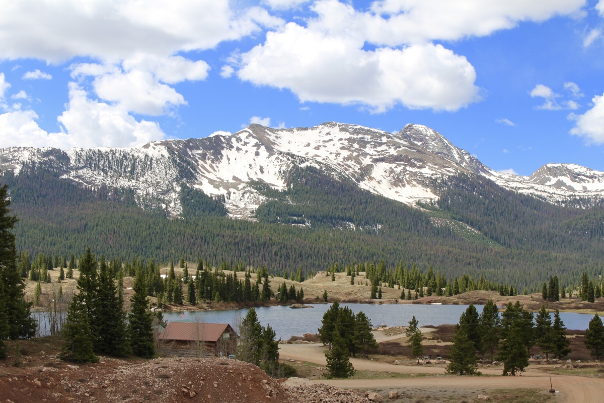
I stopped at Molas Pass (Elevation 10,910 feet). This is the last mountain pass of the Iron Horse Bicycle Classic Race, where riders race the train from Durango to Silverton. A bicyclist here asked me to take a photo of him and his bicycle in front of the scene. He took mine in return.

Molas Pass Overlook

Molas Pass Overlook

me at Molas Pass Overlook
In 1975, with additions in 1993, Congress established the 488,700-acre Weminuche Wilderness, the largest wilderness in Colorado – to forever preserve and protect this land for future generations.
San Juan Skyway Scenic Byway – Durango to Silverton
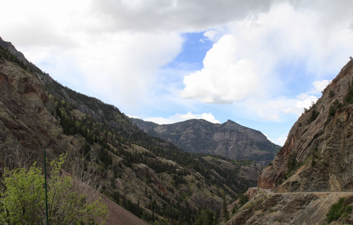
After a little over an hour, I stop for a look at the town of Silverton below.

overlooking Silverton
After stopping in the town of Silverton at 10:45 for 1 1/2 hours, I was back on the highway to Ouray at around noon. Soon I crossed the Red Mountain Pass at 11,018 feet. The name is derived from iron oxide-laden rock that forms the mountain slopes. It was the site of a historic silver boom from 1882-1893.

Red Mountain Pass

San Juan Skyway Scenic Byway – Silverton to Ouray
I pulled off to have a look over the now-closed Idarado Mine. The Idarado Mining Company was founded in 1939 in a consolidation of mining claims including the Black Bear, Treasury Tunnel, Barstow, and the Imogene Mines. In June, 1943, work began to extend the Treasury Tunnel below the Black Bear Mine to extract lead, copper, and zinc ore. As the miners drove further into the mountain, the Idarado acquired additional properties including the Ajax and Argentine Mines.
At this same time, the Telluride Mining company acquired a number of mines. Near the end of World War II, the Idarado and Telluride Mining Companies connected below ground. However, the market for minerals declined in the 1950s, forcing the companies to reorganize and sell off assets. The Idarado Mining Company eventually acquired the entire mine and continued to develop the mines until they closed in 1978.
In front of me was the historic Red Mountain Mining District. In the early 1880s, valuable columns of silver ore called “pipes” were discovered and extraction began. By 1883, nearly forty mines were sending silver ore to smelters.
During its 20-year heyday, over $30 million in silver, lead, zinc, copper and gold was extracted from this district.

Red Mountain Mining District
The history of this district mirrors the story told in countless boom-and-bust mining areas throughout the West. As prospectors, miners, cooks, freighters, prostitutes, gamblers, saloon keepers, boarding house operators, and families flooded into the area, six towns sprang up and the population increased to more than 3,000 people. The towns were Albany, Ironton, Guston, Red Mountain Town (Rogersville), Congress (Red Mountain City) and Chattanooga.

San Juan Skyway Scenic Byway – Silverton to Ouray

San Juan Skyway Scenic Byway – Silverton to Ouray
On this stretch of road were some scary drop-offs. Luckily I was northbound and hugging the mountains. I might have been terrified if I’d been on the southbound route, driving above sheer drop-offs with no guard rails.
One of the scary stretched between Silverton and Ouray
The Ouray & Red Mountain Toll Road was the most difficult road-building project attempted by businessman and builder Otto Mears. The dangerous passage through the Uncompahgre River Canyon was expensive and difficult to build, with the toll road costing nearly $10,000 per mile at the time. They had to lower men on ropes from the canyon rim to blast the quartzite walls with charges of dynamite.

San Juan Skyway Scenic Byway – Silverton to Ouray
The Uncompahgre Formation is the oldest rock exposed here, and it was eroded from even older mountains. The formation consists of mostly sandstone and shale which have changed to quartzite and slate. Ripple marks formed by moving water are visible in the vertical outcrop across the canyon. The vertical orientation shows that these rocks were tilted and were later eroded before younger rock was deposited on top of them.

San Juan Skyway Scenic Byway – Silverton to Ouray
Along the route, stands of aspens glowed even when there was little sunlight.

aspen trees

Switzerland America Lookout Point

Switzerland America Lookout Point

Switzerland America Lookout Point

Switzerland America Lookout Point
Just past the Switzerland America Lookout Point, I could see the town of Ouray below.

overlooking Ouray
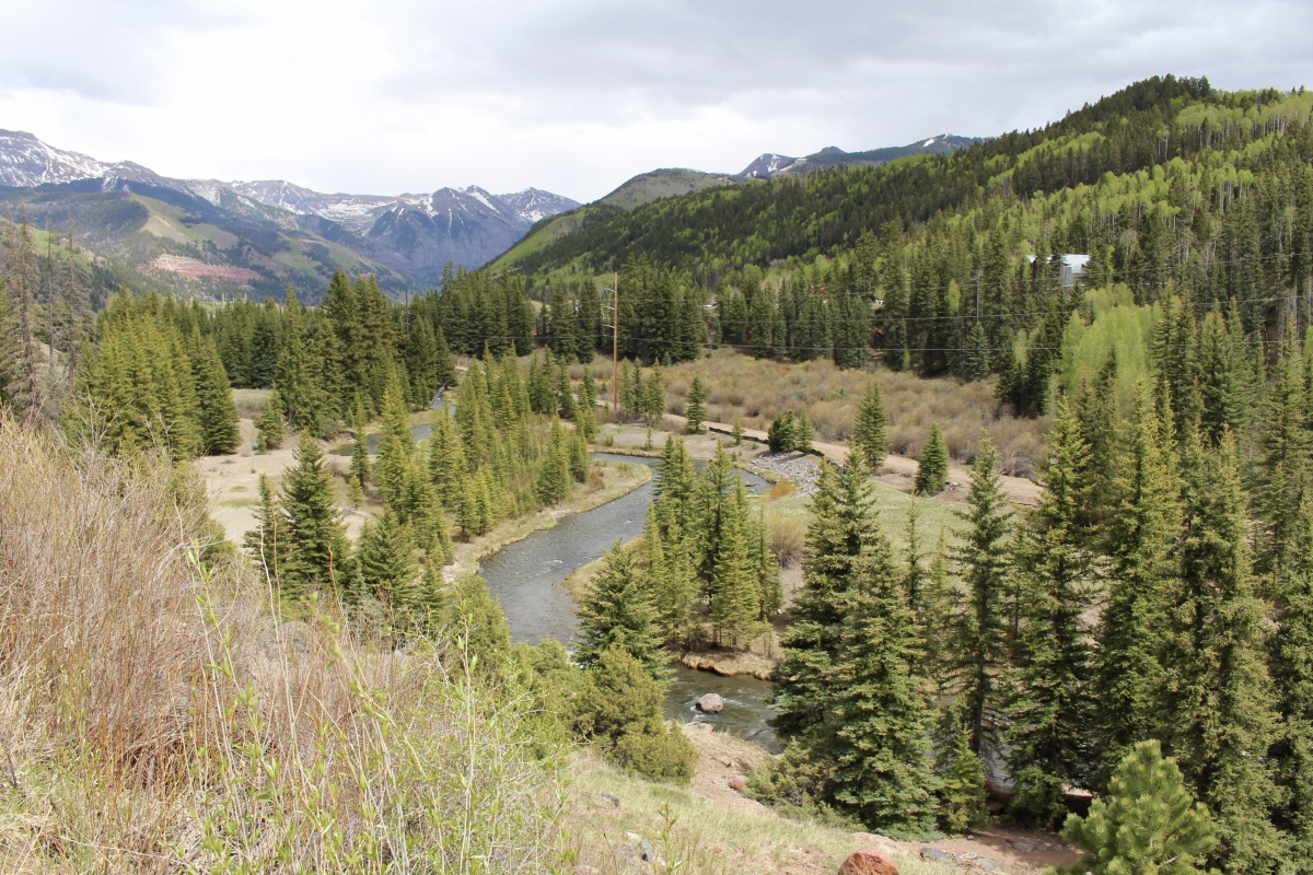
After wandering around the town of Ouray for about an hour and 15 minutes, I was on my way to Telluride, where I would spend the night. It was about 2:15 when I headed out for the last hour plus of the drive to Telluride.
After leaving Ouray, the road widened, as did the vistas. I drove between red cliffs and red mountains dotted with green pines. Lavender flowering bushes brightened the road. I passed cottonwoods along the river in a wide green valley, along with herds of cattle and picturesque ranches. I couldn’t stop to take pictures as there was nowhere to pull off the road.
On the way to Ridgway, I drove through the Uncompahgre National Forest, 955,229 acres of U.S. National Forest. Uncompahgre Peak is the 6th highest summit of the Rocky Mountains of North America and Colorado. At 14,321 feet, it is a fourteener and the highest summit in the San Juan Mountains.
As I drove into Ridgway, I passed a herd of brown cows and the Fort Smith Saloon. Soon after, a wide valley with green pastures stretched before me, backed by snow-capped peaks. Cows grazed placidly on old ranches. It was stunning!

San Juan Skyway Scenic Byway – Ouray to Telluride

San Juan Skyway Scenic Byway – Ouray to Telluride
Soon I was in San Miguel County, where I zoomed past the Dallas Divide Ranch and the Golden Bar Ranch. Cliffs of red rocks surrounded a brown log cabin in a field of green.

San Juan Skyway Scenic Byway – Ouray to Telluride

San Juan Skyway Scenic Byway – Ouray to Telluride
The lure of gold brought hydraulic mining to Keystone Hill in the 1880s. This type of mining required tremendous amounts of water to wash ore-bearing gravel from a hill.
The San Miguel River was dammed, diversion ditches were dug, and wooden flumes built to transport water to water canons at a mine site. Sectioned pipe, in smaller and smaller diameters, was used to constrict the flow of water. When water arrived at a monitor, gravity pressure blasted the water as far as 400 feet onto the hillside.
As the hill was washed to bedrock, ore-bearing gravel was fed into a wooden sluice box. Lighter material washed through the sluice and heavier material plummeted to the bottom, where it was trapped by a series of riffles. The trapped “concentrate” contained black iron sands, metallic lead … and placer gold.
Keystone Hill Overlook

Map of today’s route: Durango to Silverton to Ouray to Telluride
Information above is from various signs along the route.
You can read about the various Colorado towns along the San Juan Skyway on my previous posts:
*Saturday, May 19, 2018*
*********************
“PHOTOGRAPHY” INVITATION: I invite you to create a photography intention and then create a blog post for a place you have visited. Alternately, you can post a thematic post about a place, photos of whatever you discovered that set your heart afire. You can also do a thematic post of something you have found throughout all your travels: churches, doors, people reading, people hiking, mountains, patterns, all black & white, whatever!
You probably have your own ideas about this, but in case you’d like some ideas, you can visit my page: photography inspiration.
I challenge you to post no more than 20-30 photos and to write less than 500-800 words about any travel-related photography intention you set for yourself. Include the link in the comments below by Wednesday, May 1 at 1:00 p.m. EST. When I write my post in response to this challenge on Thursday, May 2, I’ll include your links in that post.
This will be an ongoing invitation, every first and third (& 5th, if there is one) Thursday of each month. Feel free to jump in at any time. 🙂
I hope you’ll join in our community. I look forward to reading your posts!
the ~ wander.essence ~ community
I invite you all to settle in and read a few posts from our wandering community. I promise, you’ll be inspired!
- Jude, of Travel Words, shared two photo essays: 1) of vibrant food markets and shops along Rue Mouffetard in Paris, and 2) of Monet’s water lilies in the Musée de l’Orangerie, Jardin des Tuileries.
- Jo, of Restless Jo, treats us to an exuberant celebration of Carnaval in Alte, Portugal.
Thanks to all of you who shared posts on the “photography” invitation. 🙂

Such lovely scenery, Cathy. I imagine it would be a nightmare to drive on in bad weather! You did a great job with the photos, and thanks a lot for the link. 🙂 🙂 Happy planning for the next jaunt! Glad to see on Facebook that you got your company.
LikeLiked by 1 person
I don’t even know if Colorado keeps those roads plowed in snowy weather, Jo. They must, I guess, since people in the towns have to get in and out. I sure wouldn’t want to drive on some of those cliff-side roads if they were icy, or if it were rainy and slippery.
I’m busy now getting all my planning wrapped up for Morocco and Italy. It’s less than two weeks away now. So much to do! Again, I’ve been writing posts for when I’m away; otherwise I’ll continually get further behind.
It was great to see Graham! He said he’ll come visit again when he comes to New York. We had a grand time and he and Mike really liked each other. I wish more people would come to visit. We just got our guest room fixed up (well, sort of), so we are ready for more guests. 🙂
LikeLiked by 1 person
Hopefully these vast and nice mountains in Colorado can be preserved for the future, because with your actual crazy government you never know what might happen tomorrow or even today.
LikeLiked by 1 person
You’re absolutely right. I fear for what will happen to our national parks and protected lands if this administration continues for another term; I’m even afraid of what will happen until next election day!
LikeLiked by 1 person
Glorious scenery, Cathy. Hope no one in power gets their dirty mitts on it and tries to monetize it – as I think the euphemism is today. You must be a great driver to even attempt this and your reporting of it is nerve-racking. I remember doing some horrendous mountain driving with my husband way back in sixties Spain before that country got an infrastructure worthy of it. I wouldn’t do it now.
LikeLiked by 1 person
Thank you, Mari. I hope so too; I’m really afraid of what’s happening in our greedy country today and what it will lead to as far as our national parks and protected lands.
I had heard this road was very scary, but I’d say only one stretch, between Silverton and Ouray, was that terrible. I was only glad I was on the northbound side! At least the roads were good, unlike what I can imagine you encountered in Spain. 🙂
LikeLike
I think this sort of road is probably easier for the driver than the passenger. I don’t like being on the edge and looking down. The beautiful scenery would be worth it though.
LikeLiked by 1 person
I know the feeling. I also like to feel I’m in control, which I don’t feel as a passenger. It was a beautiful drive, that’s for sure. 🙂
LikeLiked by 1 person
What a gorgeous route!
LikeLiked by 1 person
Thanks, Pit. I think you and Mary would love it. There were cyclists out there as well. That I couldn’t believe!
LikeLike
Such a wonderful scenic route. Your road looks winding, but not as narrow as some we get over here! I’d be happy driving along the route, but my OH would absolutely hate it! The first few and the last images are my favourites of the journey. A bit like driving near Bryce and Zion NPs. I had to laugh at the claim of ‘Switzerland of America’ – funny how places love to claim they are like Switzerland. In Shropshire the area around Church Stretton where we stayed before Christmas is known as ‘Little Switzerland’ on account of the hills. It does look quite magical in the snow. Again, thanks for the links, much appreciated.
LikeLiked by 1 person
Thanks, Jude. Luckily the road wasn’t too narrow; that was what I was afraid I’d find before I embarked. I also think it’s funny about the “Switzerland of America” claim. Though this is beautiful, I don’t think it comes close to Switzerland; although I’ve never been myself, I have seen photos. 🙂 Interesting about your “Little Switzerland.” So funny. 🙂
LikeLiked by 1 person
Yes, Switzerland is special. I can’t believe you haven’t been there! And Norway. Now Norway is very special.
LikeLike
Even though I’ve been to 31 countries, there are still so many places to see, Jude. I know Norway is really beautiful; I have an Instagram friend I follow who goes there frequently. I’ve neglected much of Africa and all of South and Central America. I hope to add South America to my list next year. Never been to Australia or New Zealand or any of the Pacific Islands either. Or Central Asia. So many places and so little time and money! 🙂
LikeLiked by 1 person
Well we can’t do it all, unless we have endless cash, and to be honest I am over all the flying now and happy visiting places in the UK. In fact over the last couple of years I have hardly left Cornwall! If you had told me that five years ago I would have not believed it.
LikeLike
That’s for sure, Jude. We can’t do it all, although at this point in my life, I’m still game to try as much as I can. Maybe I’ll tire of it one day. Maybe if I lived in a place like Cornwall! As for the flying, I hate it too. That’s why I’m now trying to combine two destinations if I go overseas, and why I’m doing a lot more U.S. road trips. 🙂
LikeLiked by 1 person
Beautiful. I think you said after a previous post that I would love this area, and I would.
LikeLiked by 2 people
[…] not a great big spike? And, to coin a phrase, I can gore two challenges with one horn by linking to Cathy’s Photography Theme invitation […]
LikeLike
I traveled this stretch last year with my husband, who likes to have more time at the “next” destination and doesn’t enjoy frequent stops for picture taking the way that I do. It is a real treat to see this route so beautifully documented in photos! And thank you for providing so much history of the area. I never knew that one of the mining towns was named Chattanooga, and find that fascinating because the word’s origin is from the southeastern Creek tribe (meaning “rock rising to a point”).
LikeLiked by 1 person
Thanks for the lesson about the meaning of “Chattanooga,” Marsi. This drive is so beautiful. Luckily I was on my own during this part of my Four Corners trip; my husband had to return home about halfway through our trip. Being on my own, I could stop as much as I wanted. He might not have had much patience for my many stops, although I have to give him credit for being very patient with me and my shenanigans overall. 🙂
LikeLiked by 1 person
“He might not have had much patience for my many stops, although I have to give him credit for being very patient with me and my shenanigans overall. ” Haha! The same can be said for my husband. We are lucky to have husbands that understand our need to wander!
LikeLike
We certainly are! I know I am. I think he likes it that I inspire him to step out of his comfort zone. 🙂
LikeLiked by 1 person
[…] the san juan skyway scenic byway: durango to telluride March 21, 2019 […]
LikeLike