
As we made our way back to the north entrance of the park, we stopped at Grand View, where we enjoyed a panorama including Independence Monument, Grand Valley, and the Book Cliffs.

Independence Monument from the Grand View

wildflowers at the Grand View

Monoliths seen at the Grand View
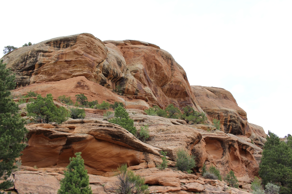
At the viewpoint, we could almost reach out and touch a 200-foot tall sandstone spire. The top layer of this spire is the Kayenta Formation, more resistant to erosion than other sedimentary rocks in the park. This formation was deposited by a high-energy braided river system similar to the Rio Grande River in New Mexico. The bottom layers are the Wingate Formation, a tan sandstone whose sweeping tilted layers tell us this rock was deposited in a desert environment where wind-swept sands accumulated and were buried. An environment like this can be found in the modern Sahara Desert of North Africa.

The Grand View
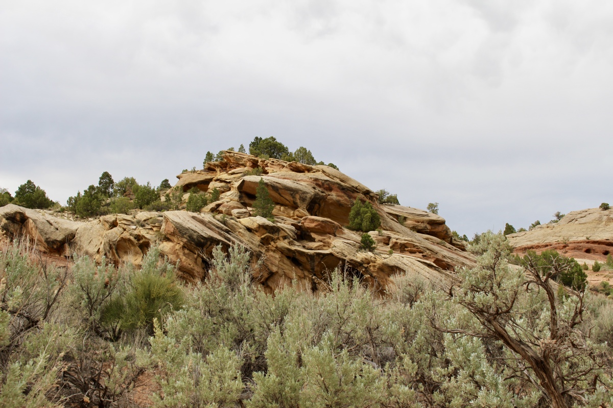
The cliffs and monoliths of the Monument are made primarily of sandstones over 200 million years old.

The Grand View
We took two more hikes at Colorado National Monument to wrap up our day. We stopped to walk on Otto’s Trail, a gently sloping trail of 0.95 miles, where we enjoyed dramatic views of many monoliths. We were walking in the footsteps of John Otto as we followed the route he used for his first ascent of the 450-foot high Independence Monument.

dead juniper on Otto’s Trail

John Otto’s climb on Independence Monument
Independence Monument from Otto’s Trail
On this late afternoon, we spotted some climbers atop Independence Monument. I don’t know if they were enjoying the view or too terrified to come down! Years ago, I climbed Pilot Rock in Oregon with my first husband and his best friend. Climbing up was fine, although a little scary, but when it was time to come down, I was so terrified I couldn’t do it. I cried, wept actually, and told them they were going to have to call a helicopter to rescue me. Finally, inch by inch, they encouraged me to climb down as they stood beneath me (as if they could really catch me if I fell!). I am careful now not to go up anything so steep that I’d be afraid to come down.

Rock climbers on Independence Monument

view from the end of Otto’s Trail
We stopped at the Balanced Rock View on our way out of the northern entrance. Balanced Rock is a snapshot in time that won’t last forever. Gravity will someday cause it to fall.

Balanced Rock view
We had to drive outside of the park and to the southeast entrance to do the Devils Kitchen Trail. It took us about an hour to hike to a natural rock room formed by huge upright boulders.

cacti along the Devils Kitchen Trail

Devils Kitchen Trail
I loved how the cottonwood trees glowed in the sunlight.
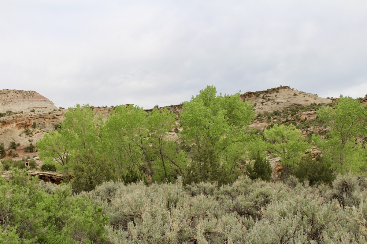
cottonwoods along the Devils Kitchen Trail

Devils Kitchen Trail

Devils Kitchen Trail

flora along the Devils Kitchen Trail
Devils Kitchen Trail

cacti along Devils Kitchen Trail

cacti along Devils Kitchen Trail
We crossed a wash and then climbed uphill on a slickrock bench to get to the Devils Kitchen. The trail was a bit confusing and we got on the wrong track several times.

Devils Kitchen Trail

Devils Kitchen Trail
Devils Kitchen is a natural rock room surrounded by Wingate Sandstone cliffs, and provides a bit of a resting spot after the steep ascent.


I loved looking at the patterns on the towering rocks.

inside Devils Kitchen

Devils Kitchen Trail

Devils Kitchen

Devils Kitchen Trail
Devils Kitchen Trail
The Devil’s Kitchen hike was 2.7 miles and took us a 1:04 hours. Between getting out for the various viewpoints and the hikes we took, we walked 18,913 steps, or 8.01 miles, over the course of the day.
On the way out of the park, we passed by the Book Cliffs along the southern and western edge of the Tavaputs Plateau.


** Monday, May 7, 2018 **
***********************
On Sundays, I plan to post various walks that I took on our Four Corners trip as well as hikes I take locally while training for the Camino de Santiago; I may also post on other unrelated subjects. I will use these posts to participate in Jo’s Monday Walks or any other challenges that catch my fancy.
This post is in response to Jo’s Monday Walk: Same river, different city.

Lord, Cathy! My heart is still beating fast at seeing those climbers on the lip of that rock! I know exactly what you mean and have experienced similar myself. As you grow older confidence and footsuredness diminishes and fear sets in. I would not attempt anything like that now. In fact, Mick had to hold my hand as we scrambled off the top of the dunes down to the beach yesterday. He said ‘what a wuss!’ Thanks so much for linking this, hon. The photos and scenery are superb. 🙂 🙂 Happy Sunday!
LikeLiked by 1 person
I would have loved to know what was going on in those people’s heads as they stood up there on that ledge, Jo. First, I can’t imagine climbing such a thing, but then to contemplate coming down would be terrifying. Even standing on top of a place with such a steep drop off would scare the living daylights out of me. I often have to lean on Mike as I make my way down steep paths. Lately, when I use my walking poles, which I’ll definitely use on the Camino, I can make it downhill more confidently.
Happy Sunday to you too. Alex just arrived at 5:15 a.m. from Denver for a week-long visit. It’s great to see him again. 🙂
LikeLike
That’s nice. Enjoy his company 🙂 🙂 It’s really close and muggy here today. We were going to Leeds but James was involved in a bit of an incident watching the World Cup yesterday (somebody always has to spoil it) and he’s just taking the little one to the park with friends for a picnic so we’ll chill. Went to an open air reenactment last night and were late home. Have fun! 🙂
LikeLike
Sorry about missing out on your visit with James. That World Cup! Just chilling sounds like a good way to spend a Sunday, though. We’re lucky at this moment; a cold front moved in Friday night and yesterday was and today is cool and stunningly perfect. Sunny, no humidity, cool air – it’s just my kind of weather. Sadly tomorrow it will start getting hot and humid again!
LikeLiked by 1 person
I’m on your page, Jo…can’t do heights now….
LikeLiked by 1 person
Going up is not so bad, but there’s up and up. This ‘up’ is serious stuff! 🙂 🙂
LikeLiked by 2 people
Quite!
LikeLiked by 2 people
It is interesting how often the world devil or hell is used for naming places in the mountains. A Devil’s Mountain is also nearby me, just 15 minutes ride with me bicycle to go there. In fact it is more a hill created after WW II when all the rubbish and debris of destroyed houses was piled there being now a real secondary jungle after 70 years. Cheers @ Ulli
LikeLike
That is interesting, Ulli. I have several more Devils places to post about, although no “hell” ones from this trip! Interesting how your Devil’s Mountain is really a jungle grown over a WWII trash heap! That is the devil for sure!
LikeLiked by 1 person
Amazing vistas, I am not a lover of heights though I can’t help but like these photos!
LikeLike
I’m very cautious around heights, Suzanne, but I do love the views they offer. Thanks, I’m glad you like the photos. 🙂
LikeLiked by 1 person
Wow, hats off to you for distance hiked. Sounds like you had quite a workout! And amidst such gorgeous scenery. Just beautiful.
LikeLike
Thanks, Wendy. We had many stops along the way, breaking up our various hikes, but we did put in some nice mileage on this day. The scenery was beautiful. I miss desert landscapes since I left Oman in 2013. 🙂
LikeLiked by 1 person
Another wonderful post on ‘the Monument’. I remember the hike to Devil’s Kitchen that I took with my brother and sister-in-law. We found the trail a tad confusing, but oh so fun and it was the perfect way to ease into some of the other hikes around.
LikeLike
This is my last post on Colorado National Monument, Ingrid. On to Arches next. We were a little confused by that trail too, especially once we got on the slickrock. It wasn’t too strenuous, but I liked the Devils Kitchen at the end and the different views from inside the canyon, rather than from the rim. 🙂
LikeLiked by 1 person
I can’t even imagine how those climbers got up to that spot in the first place, let alone how they got down again. I’m not that adventurous. Lovely photos, Cathy.
LikeLike
I can’t imagine doing it either, Carol, but I guess they must be experienced rock climbers who followed Otto’s route as marked on that sign. How they got down, I’ll never know. We stood for some time waiting for them to start to descend, but they didn’t seem in any hurry and we had to move on. I’d never be that adventurous myself!
LikeLiked by 1 person
The rock formations in this region are simply stunning. I could drive and walk around these for days admiring the different colours and structures. Wonderful photos Cathy. Like most people have commented, those stacks are not for climbing! I was heading up to a summit in the Australian Grampians National Park (also sandstone) when I was about 46 and as we reached the point where the trail turned into scree I decided I had climbed high enough. I knew that even if I could continue upwards there was no way I’d get back down that terrain. As for climbing sheer cliffs – never!
LikeLike
I agree, Jude. Every rock formation has its own unique character and has so much deep history behind it. I could wander around them forever, and you can imagine how many pictures I took! I can’t imagine climbing Independence Monument, but people do it every 4th of July! I wouldn’t do it in a million years. Not only am I not in shape to do such a thing, but I’d be terrified! When a trail turns to scree, I always count myself out. I’m afraid I’ll run into some of that on the Camino (I’ve been told to expect it), but I hope my hiking poles will help keep me from sliding down a mountain!
LikeLike
[…] Ottos’s Trail & The Devils Kitchen Trail at Colorado National Monument […]
LikeLike
What a contrast between the red rocks, and the cool shades of the Book Cliffs!
LikeLike
You’re so right, Gilly. It was quite a contrast. A very unusual landscape at every turn! 🙂
LikeLike
I’ve read this umpteen times – or if I’m honest read it once and looked at the pictures umpteen times – and always got sidetracked before commenting. An absolutely beautiful landscape, beautifully photographed and impressively walked. The Camino will be a piece of cake. Of course I’m interested in the geology too. Your four corners jaunt keeps giving.
LikeLike
That’s so funny, Meg. That happens a lot to me too! It was a gorgeous trail, the best of the day, and the early evening light made it special.
I don’t know that the Camino will be a piece of cake! I wish, but I’m prepared to expect and deal with a lot of challenges. That is one of the purposes, as I see it. 🙂 There is still so much to come from the Four Corners! It does keep giving. 🙂
LikeLike
Lovely photos. That landscape really puts things in perspective. It’s awe-inspiring to me the sheer size of the sandstone monoliths and the way time has carved them.
LikeLike
Thank you so much, Atreyee. I was awestruck by that landscape and the sheer magnitude of it. 🙂
LikeLiked by 1 person
I’m loving being with you on this wonderful journey of exploration Cathy the scenery is mind blowing and you should put this in the new photo challenge the first theme is “wonder” and this is just wonderful. Loved going inside the Devil’s kitchen and a close look at all the patterns and swirls.
LikeLike
Thanks so much, Pauline. This area was all so new and amazing to me, as I’ve never explored this part of the country before. I love the close ups of the rocks; they’re so weathered and tell of such a long varied history. 🙂
What is the new photo challenge? I thought WordPress discontinued their photo challenge??
LikeLiked by 1 person
here’s the link to the new photo challenge and all the details https://pilotfishblog.com/2018/07/07/lens-artists-weekly-photo-challenge-wonder/
LikeLike
Thanks for sending me this link, Pauline. I hope I can find time to participate. I’m trying to write blog posts ahead of time to schedule while I’m walking the Camino, but I don’t know if it’s possible with the time I have left. Plus I’m training, which is time-consuming. But it would be nice if I could come up with something! 🙂 I’ve subscribed to all four blogs!
LikeLiked by 1 person
I’ve been trying not to get involved with challenges, but try to work this one in with my happenings. I was impressed how Jill managed to post as she walked, that must’ve been hard to do
LikeLike
I know what you mean, Pauline; the challenges are fun and introduce you to a lot of new bloggers, but they also take time away from other goals you set for yourself. As for blogging on the Camino, I don’t plan to take along a computer or an iPad, and I hate to make posts from my phone. I’m thinking I may put one picture a day up on Instagram and that’s about it. I’ll keep my journal, but I have to minimize my pack weight and I don’t want to get caught up too much in the virtual world when the real world will be all around me! 🙂
LikeLiked by 1 person
That is very sensible and I’m sure your journal will take a lot of your time too as there will be so much to record
LikeLike
I agree, Pauline. My journal hopefully will be filled to the brim during my journey. 🙂
LikeLiked by 1 person
I’ll be looking forward to hearing all about it
LikeLike
Amazing scenery! Like everyone else, I get the collywobbles at the thought of climbing that monument. I don’t do scree either.
LikeLike
Thanks, Anabel. I like that word, collywobbles! I couldn’t and wouldn’t climb anything like that; and I try to avoid scree at all costs.
LikeLiked by 1 person
I love the close ups…huge rocks…and I can see faces in them too 💫☺️❤️ smiles hedy
LikeLike
Thank you, Hedy. I liked being in that Devils Kitchen and having those rocks looming all around me.
LikeLike